DESCRIPTION
First ascent to the peak of Akademik Kalesnik via the buttress of the eastern wall, approximately category 3B difficulty. From the base camp, located on the upper forest boundary, on the right (orographically) bank of the Amanauz River, ascend the gorge through thickets of birch, willow, raspberry, and rhododendrons. After the vegetation ends, cross to the left (orographically) bank of the Amanauz River. Then, with a gradual gain in altitude, move towards the sharp black moraine. Before reaching it, turn sharply to the right and move towards the gap in the "ram's foreheads". Ascend a wide couloir with scree and a stream to the tongue of the glacier. The glacier tongue is at an altitude of 2700–2750 m. Then, exit to the right, beyond the rocky ridge, gaining altitude, and reach a snowy slope with a steepness of 35–45°. Move straight up this snowy slope for 400 m, then exit to the left through the rocky ridge onto the glacier. Then, ascend a steep ice-and-snow slope of the glacier for 600 m on crampons. The slope's steepness is 50–55°. Move in rope teams, using the entire rope! The slope leads to the upper plateau of the glacier. The altitude of the upper plateau is 3000 m. Then, traverse 500 m across the glacier towards the wall of peak Akademik Kalesnik. The slope's steepness increases after the first 500 m and reaches 15–20° for the next 500 m. The last 100 m have a sharply increasing steepness, reaching 50–55°. In front of the wall, there is a very wide randkluft, which is a serious obstacle on the way to the wall. It is necessary to descend into the randkluft and then start working on the wall at a depth of 8–10 m from the upper edge of the randkluft.
The wall is monolithic and sheer. The first 40 m have a steepness of 85–90°. Belays are only with pitons. From the randkluft, ascend upwards to the right to a small platform – 10 m. The platform is convenient for belaying. From the platform, ascend upwards to the left for 10 m, then 20 m straight up. Climbing is difficult, with piton belays. The next 20 m of the wall are overhanging, with a steepness of 93–95°. Climbing is very difficult. Belays are with pitons! During the passage of these 60 m, 21 pitons were used. After passing this 20-meter overhanging wall, exit onto a platform. Control cairn!!! On the platform, there is a good protrusion-flake, which is convenient to use for belaying.
On the next 30 m, the wall becomes less steep, reaching 80–85°. The wall is climbed with piton belays and leads to a ledge. Along the ledge, ascend to the right upwards for 5 m, from where exit onto slabs with a steepness of 75–80°. Ascend the slabs straight up for 25 m with difficult climbing and piton belays (7 pitons used).
After the slabs, the rocks become less steep, reaching 65°. The rocks are easy. Then, ascend straight up for about 100 m on easy rocks, initially with a steepness of 65°, but in the second half of this section, the steepness increases to 75–80°. After this section, exit onto the ridge. Then, move upwards to the left, to the right of the ridge, across snowy slopes with a steepness of up to 60°, with alternating belays for 300 m. After this section, ascend 100 m on easy rocks with a steepness of 60°, then exit directly onto the ridge, leading to the pre-summit rise. Then, ascend the rise for about 140 m to reach the summit.
The route takes 5 hours to complete. Descent to the south via the category 2A route. To the glacier – 1 hour. Then, return to the base camp through the Amanauz pass – 5–6 hours.
Recommendations:
- Main ropes — 2x40 m.
- Crampons — 4 pairs
- Ice screws — 3 pcs.
- Pitons — 15–18 pcs.
- Climbing carabiners — 20 pcs.
- Tent — 1 pc.
- Stove — 1 pc.
- Ice axes — 4 pcs.
- Rock hammers — 2 pcs.
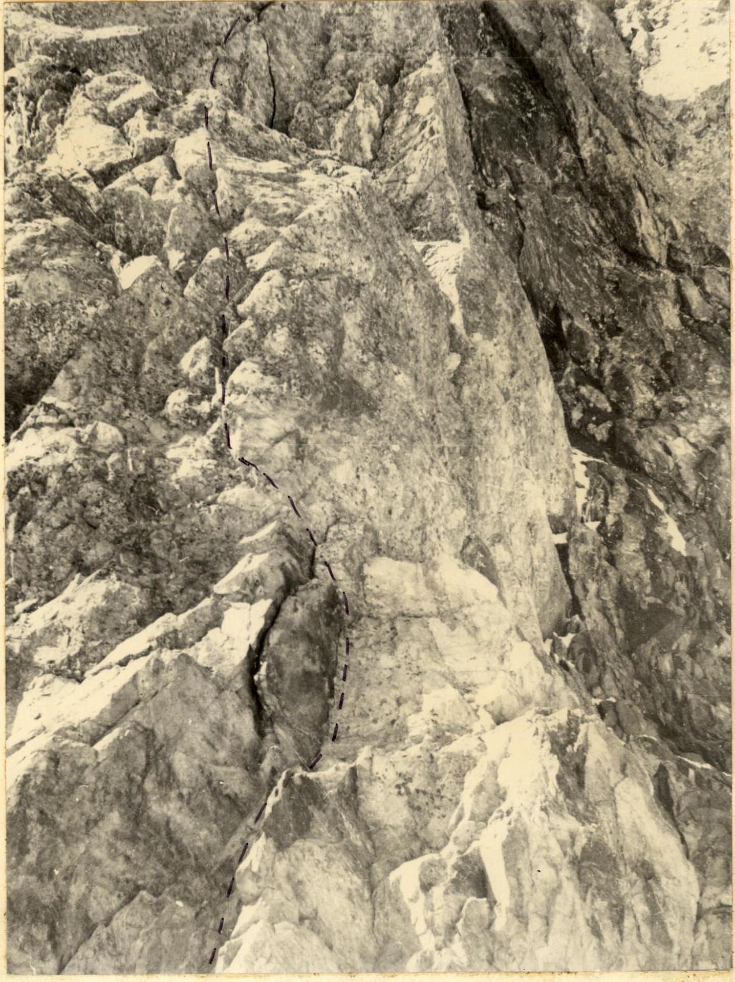 Lower part of the wall
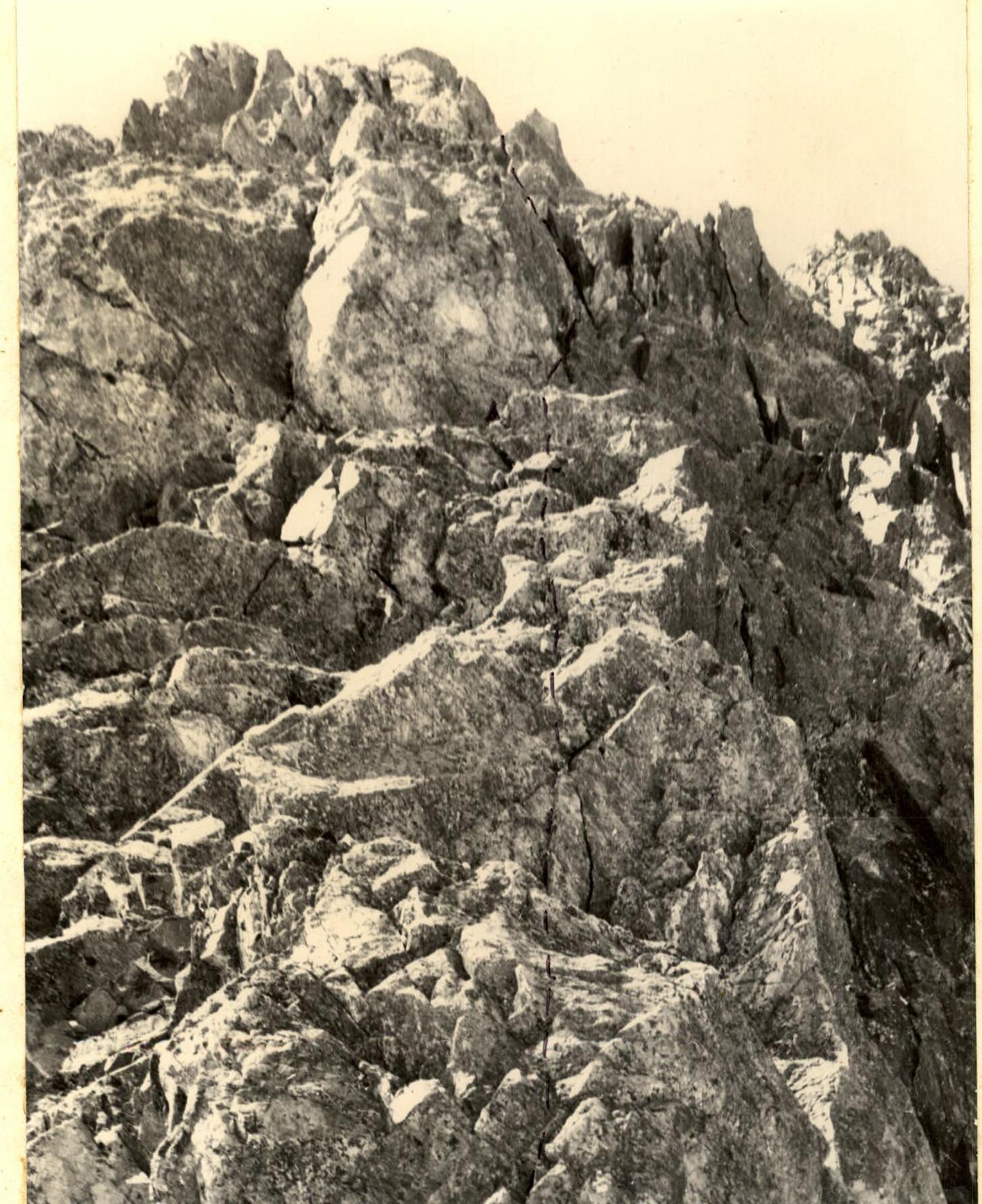 Upper part of the wall (with a control cairn).