
Geographic Overview of the Area
The AGEPSTA massif is a standalone ridge with the dominant peak GLAVNAYA AGEPSTA (3261 m), dropping off to the north with walls up to 80 ° steep and a height difference of 1000 m. It is located on the border between Krasnodar Krai and the Georgian SSR.
It is bounded to the west by the Aibga ridge and the Turii mountains, to the east by the Atskentsi ridge, to the north by the Mzymta River, and to the south by the Gegra River.
From a geographical point of view, the AGEPSTA massif is part of the Southern Front Ridge. It stretches parallel to the Main Caucasian Ridge between the upper reaches of the Tikhaia and Agepsta rivers. It is 10 km long, with heights ranging from 2800 to 3200 m, and is composed of marl, conglomerates, limestones, diorites, tuffs, and other rocks from the marine and Cretaceous periods.
Glacial landforms are well-developed:
- cirques;
- karst formations;
- glaciers (the largest being Khyms-Aneke) cover about 5 sq. km.
The lower slopes feature mountain meadow vegetation, beech and beech-deciduous forests, rhododendron, and plenty of berries such as currants, blueberries, and bilberries.
High precipitation (up to 6 m of snow in some years) and a sharp temperature scale contribute to the breakdown of rocks.
The climate of the area, according to the classification of climates in the USSR, is humid in the southern part of the transitional climates of the temperate zone, and a narrow strip of the Black Sea coast is located in the area of transitional climate of the subtropical zone.
The influence of the two seas — the Black Sea and the Sea of Azov — determines a great peculiarity in the climatic conditions of the area. The average annual air temperature of the area is below -10 °C, while on the Black Sea coast, just 50 km away, it is above +10 °C.
The amount of precipitation depends on the exposure of the slopes:
- On the southern slopes facing the sea, the average annual precipitation is about 2600 mm;
- On the northern slopes, it is 980 mm.
Typically, the weather is good with minimal precipitation and cloud cover in June-July.
Autumn and winter are characterized by abundant snowfall. The weather did not favor us in October 1978. On the northern slopes of AGEPSTA, on the eve of the ascent, about 1 m of snow fell. The weather was wintry cold, on the route:
- a large amount of ice,
- plenty of snow.
Approach to the Route Description
From the base camp located on Lake Kardyvach, follow the right orographic bank of the Mzymta River downstream along the tourist trail to the confluence of the Mzymta and Tikhaia rivers (12 km).
At the confluence:
- Cross to the left bank of the Dlinnaya River
- 1.5–2 km upstream to the crossing to the right bank
Along the right bank of the Tikhaia River upstream for 3–3.5 hours to the Skazochnaia meadow. The trail from Lake Kardyvach to the Skazochnaia meadow passes through an evergreen coniferous forest. Along the way, you will encounter:
- high-altitude maple trees
- birches
- alder trees
On the meadow, the first bivouac (8–9 hours from Lake Kardyvach).
From the meadow:
- Along the left bank of the Tikhaia River to the slopes of the Atskentsi Ridge, covered with krivolesie (crooked forest) — 50 minutes.
- Then, up a steep grassy slope, occasionally transitioning into medium and fine scree, avoiding krivolesie areas via streams, ascend to the moraine of the Khyms-Aneke glacier — 4–4.5 hours to the Army Overnight Camp (landmark — to the left of the camp on the rock wall at a height of 60–70 m, an entrance to a cave).
At the overnight camp, the second bivouac.
From the overnight camp, up the medium scree to the glacier, bypassing the "ram's foreheads" on the left, up a steep snowy slope to the glacier. (The glacier is heavily broken; crampons are necessary) and, crossing it from left to right, avoiding crevices and icefalls on the left as you go, approach the start of the route (2.5–3 hours).
The landmark is the ice couloir on the Eastern wall of the northeastern ridge (couloir in the shape of a "sickle").
Table
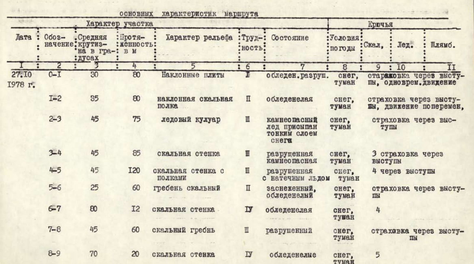
| Date/Designation | Average Steepness in Degrees | Length in m | Nature of Relief | Difficulty | Condition | Weather Conditions | Rock Climbing | Ice Climbing | Pitons |
|---|---|---|---|---|---|---|---|---|---|
| 27.10 1978 g. 0–1 | 30 | 80 | Inclined slabs | 1 | icy, broken | snow, fog | insurance through ledges, simultaneous movement | ||
| 1–2 | 35 | 80 | inclined rock shelf | 2 | icy | snow, fog | insurance through ledges, alternating movement | ||
| 2–3 | 45 | 75 | ice couloir | 3 | rockfall hazard, ice covered with a thin layer of snow | snow, fog | insurance through ledges | ||
| 3–4 | 45 | 85 | rock wall | 3 | broken, rockfall hazard | snow, fog | 3 insurances through ledges | ||
| 4–5 | 45 | 120 | rock wall with shelves | 3 | broken with ice | snow, fog | 4 through ledges | ||
| 5–6 | 25 | 60 | ridge rock | 2 | snowy, icy | snow, fog | insurance through ledges | ||
| 6–7 | 80 | 12 | rock wall | 4 | icy | snow, fog | 4 | ||
| 7–8 | 45 | 60 | rock ridge | 3 | broken | snow, fog | insurance through ledges | ||
| 8–9 | 70 | 20 | rock wall | 4 | icy | snow, fog | 5 | ||
| 9–10 | 40 | 80 | rock ridge | 2 | snowy | snow, fog | insurance through ledges | ||
| 10–11 | 75 | 25 | rock wall | 4 | snowy | snow, fog | 5 | ||
| 11–12 | 30 | 300 | snow ridge | 2 | snow, fog | simultaneous movement |
Time to reach the route: 06:00; climbing hours to the summit 9 hours, descent from the summit — 3 hours.
Description of the Ascent to the Summit of Agepsta Main
The beginning of the route is the ice couloir in the shape of a "sickle" located on the eastern wall of the northeastern ridge.
After traversing 2 ropes (75–80 m) left along the ice slope and overcoming the bergschrund via a snow bridge, we reach a wide 2–3 m snow shelf. The first control cairn is located on this shelf.
Along it, traverse right upwards for 80 m to the start of the ice couloir ("sickle"), steepness 35–45 °. The route then proceeds along the Eastern wall of the northeastern ridge of AGEPSTA.
After climbing 2 ropes (75–80 m) up the ice couloir, we approach a large overhanging rock at the gorge of the couloir (caution, rockfall hazard!!). Bypassing the gorge on the right via rocks of medium difficulty, with small walls 2–3 m (2 ropes, 80–85 m), we emerge back into the ice couloir. Staying on the right side of the couloir, along the heavily broken rocks of the eastern wall of the northeastern ridge, we proceed another 120 m (insurance through ledges and pitons).
Rocks with ice and small shelves, and we emerge onto the northeastern ridge of AGEPSTA. Along the ridge, bypassing a "gendarme" on the left (60 m), we approach a rock wall 10–12 m, covered with ice (steepness 80 °, difficult climbing); piton insurance, 4 rock pitons hammered. Then 60 m along rocks of medium difficulty, we approach the 2nd wall (20 m, 70 °), 5 rock pitons hammered. Rocks with ice, climbing is difficult. Further along the ridge and simple rocks (2 ropes, 90 m), we approach the third wall (25 m, 75 °). We pass the wall in the center, piton insurance, climbing is difficult, 5 rock pitons hammered. Then along a gentle snow ridge 250–300 m, we reach the summit of GLAVNAYA AGEPSTA.
The descent is via the ascent route. On the descent, 4 pitons were hammered. From the "Army Overnight Camp" to the summit and back 9–12 hours.
The ascent was made in poor weather conditions:
- rain that turned to snow,
- gusty wind,
- fog,
- visibility at times down to 10 m.
4242.0 m — height along the route of sector change
Communication: 10–11
Protocol
Analysis of the first ascent of the summit AGEPSTA GLAVNAYA by a group of climbers No. 5 of the Sports Club of the Army, SKVO
ATTENDED:
- Zetyukov S.A. — leader of the ascent
- Pogosyan F.L. — participant
- Gorban A.I. — participant
- Bulgakov V.N. — participant
- Dokuchaev V.B. — participant
- Akulov Yu.I. — participant
- Kisel S.Ya. — supervisor
ZETYUKOV: The ascent took place in very difficult weather conditions. Lots of snow, ice, poor visibility. Overall, the route was liked, there are quite saturated places in terms of mountaineering. The greatest difficulty was presented by three rock walls before reaching the pre-summit ridge. The route is extensive, from the camp to the summit 9–10 hours. 21 pitons were hammered. On the descent, we hung 4 sports anchors. Preliminarily, I evaluate the route as category 3B.
Regarding the participants: the ascent was made in three ropes:
- Pogosyan–Akulov
- Zetyukov–Bulgakov
- Gorban–Dokuchaev
All participants showed themselves only in a positive light, as true fighters. They had no complaints against their partners or other participants.
AKULOV: The route is good. I liked it very much. A real winter ascent, Zetyukov has already spoken about it. It seems to me that the route can be rated around 4A. I liked the collectivism and sports spirit during the ascent.
DOKUCHAEV: The guys have said almost everything, I don't want to repeat. I support Akulov regarding the classification of the route — 4A.
BULGAKOV: The work of the ropes and the route were liked. Real winter: snow, wind, cold. I rate the route 4A.
POGOSYAN: The ascent was made in quite complex meteorological conditions. Almost all participants have spoken about this. I just want to add that despite the fact that the route is quite complex and interesting, we must take into account that we made the ascent in bad weather and, to be honest, it doesn't quite reach 4A. It's a good 3B. Personally, I propose to rate it 3B, and Sergey Yakovlevich won't go for a dubious category.
KISEL, supervisor, Master of Sports of the USSR: The summit is good, we spent a lot of time, if not all participants are sure it's 4A, then we'll submit it as 3B. The ascent is to be counted, the management too.
Secretary S. YAKOVLEV
SUPERVISOR S. KISEL 
Comments
Sign in to leave a comment