Report
On the ascent to the summit of Kush-Kaya via the "Zigzag" route on the southwestern wall 2A CATEGORY OF COMPLEXITY by the team of the Crimean Republican Public Organization "Alpine Club 'Kategoriya Trudnosti'" on October 26, 2022
I. Ascent Passport
| № п.п. | 1. General Information | |
|---|---|---|
| 1.1 | Full Name, Sports Rank of the Leader | Sitnik Mikhail Aleksandrovich MSMSK |
| 1.2 | Full Name, Sports Rank of the Participants | Boyko Lyubov Alekseevna MS |
| 1.3 | Full Name of the Coach | Sitnik Mikhail Aleksandrovich |
| 1.4 | Organization | Alpkлуб «Kategoriya Trudnosti» |
| 2. Characteristics of the Ascent Object | ||
| 2.1 | Region | Crimea |
| 2.2 | Valley | Batiliman |
| 2.3 | Number of the Section according to the Classification Table of 2013 | 10. |
| 2.4 | Name and Height of the Summit | Kush-Kaya 664 m |
| 2.5 | Geographical Coordinates of the Summit (Latitude/Longitude), GPS Coordinates (1) | N 44.425131, E 33.679880 |
| 3. Characteristics of the Route | ||
| 3.1 | Name of the Route | "Zigzag" on the southwestern wall |
| 3.2 | Proposed Category of Complexity | 2A |
| 3.3 | Degree of Route Exploration | 3rd ascent |
| 3.4 | Relief Nature of the Route | Rocky |
| 3.5 | Height Difference of the Route (data from altimeter or GPS) | 350 m |
| 3.6 | Length of the Route (in meters) | 670 m |
| 3.7 | Technical Elements of the Route (total length of sections of various complexity categories with indication of relief nature (ice-snow, rocky)) | I cat. rocky — 100 m. II cat. rocky — 300 m. III cat. rocky — 185 m. IV cat. rocky — 90 m. |
| 3.8 | Descent from the Summit | Non-technical descent via a trail to the Batiliman tract |
| 3.9 | Additional Characteristics of the Route | Presence (absence) of water |
| 4. Characteristics of the Team's Actions | ||
| 4.1 | Time of Movement (team's walking hours, in hours and days) | 4 hours |
| 5. Person Responsible for the Report | ||
| 5.1 | Full Name, e-mail | Sitnik M.A. rocksport@yandex.ru |
II. Description of the Ascent

General view. The "Zigzag" route is marked in yellow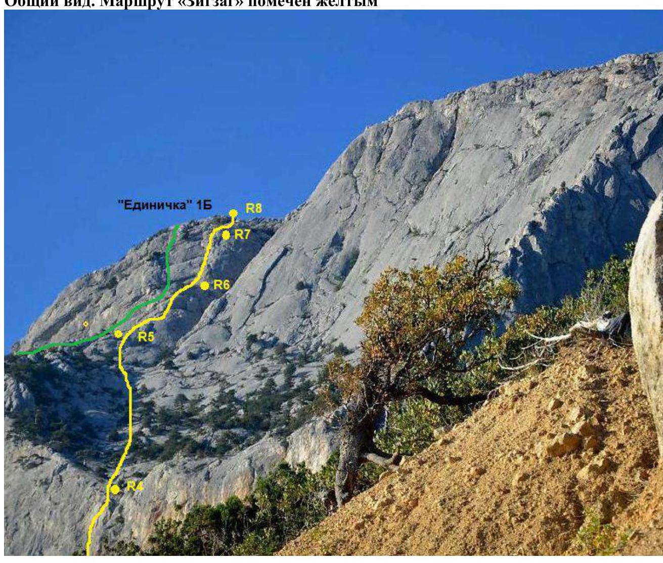
2. Characteristics of the Route
| Section № | Relief Nature | Category of Complexity | Length, m | Type and Number of Pitons |
|---|---|---|---|---|
| R0–R1 | Internal corner Narrow ledge Internal corner Sloping ledge | 3+ 2 2+ 2 | 15 5 10 20 | 3 2 |
| R1–R2 | Ledges with trees | 1-2 | 120 | |
| R2–R3 | Internal corner | 4+ | 30 | 8 |
| R3–R4 | Chimney Slope | 3 1 | 15 45 | 1 |
| R4–R5 | Ledges, small walls | 2 | 150 | |
| R5–R6 | Walls, ledges along the ridge | 2-3 | 100 | 3 |
| R6–R7 | Summit wall | 4 | 60 | 9 |
| R7–R8 | Slope Short wall | 2 3 | 15 5 | 1 |
From the parking lot under Kushkaya mountain, follow the trails to reach the "Africa" sector (0.5 hours), then:
- to the right of the "Africa" sector, ascend the scree couloir upwards and leftwards towards the wall of the "Pink Belt" sector,
- under it, move left to the highest point of the ledge,
- from there descend 15–20 m down and along a narrow ledge reach the ledge under the start of the route near a large strawberry tree (0.5 hours).
R0–R1: ascend 15 m up a moderately complex internal corner, move left along a ledge, and then ascend 40 m leftwards via a sloping internal corner and ledges. The belay station is on a small tree.
R1–R2: Move right and upwards along ledges with trees for 120–130 m, easy climbing. The belay station is in a niche under a chimney plug (pitons are hammered).
R2–R3: From the station, move 3 m right and start ascending a vertical internal corner with piton protection and artificial holds. After 25 m, the right wall starts to overhang:
- move to a ledge on the left
- ascend through a wall with a slit to the next ledge
The belay station is on pitons and artificial holds.
R3–R4: From the station, move left into a chimney and ascend about 15 m up an overgrown chimney, then ascend a simple slope overgrown with spurge towards the neck of a large forested cirque. The belay station is on a tree.
R4–R5: From the station, move straight up into the cirque and along it (ledges, small walls, protection on trees) move 150–180 m left and upwards towards a wall located higher on the left behind a large internal corner. The movement involves:
- ledges,
- small walls,
- protection on trees.
The belay stations are on trees.
R5–R6: The last station on this section (R5) is on a shoulder (ridge) before the summit wall. Ascend along short walls and ledges on the shoulder towards the wall for 100 m and reach a ledge. The internal corner (route "Edinichka") starts from the left part of the ledge. The belay station is on a juniper bush.
R6–R7: From the right part of the ledge, near the juniper bush, enter an internal corner (old piton), ascend 10 m under an overhang. Under the overhang, move right and ascend a wall with a small internal corner towards the next wall. Bypass the wall on the left via a slit, then ascend moderately complex rocks to a ledge. The belay station is on a tree. To reduce rope friction, it's advisable to divide this section into two, creating an intermediate belay station:
- under the second wall
- on your own protection points
R7–R8: Continue moving straight up along a sloping ledge (slope) and through a short 5 m wall to reach the yayla.
Descent via one of the trails to the Batiliman tract takes 1 hour to the road. The route is logical and follows the simplest path on the southwestern wall of Kushkaya mountain. There are signs of previous ascents on some sections (pitons). The key section of the route — R2–R3 — involves partially destroyed rocks, so the R2 belay station is located in a safe grotto to the left of the route line, protected from rockfall.
The route is more complex and longer than 2A "Svardebnaya" ("Dyroka") on Chelebi and 2A "Grebnevaya" ("Rebro") on Maly Kils, but simpler than:
- 2B "Classics" on Kushkaya,
- "Telezhenko",
- "PK" on Forossky Kant.
Given the limited number of 2A category routes in the Southern Crimea, we believe it's correct to classify this route as 2A category. M. Sitnik

