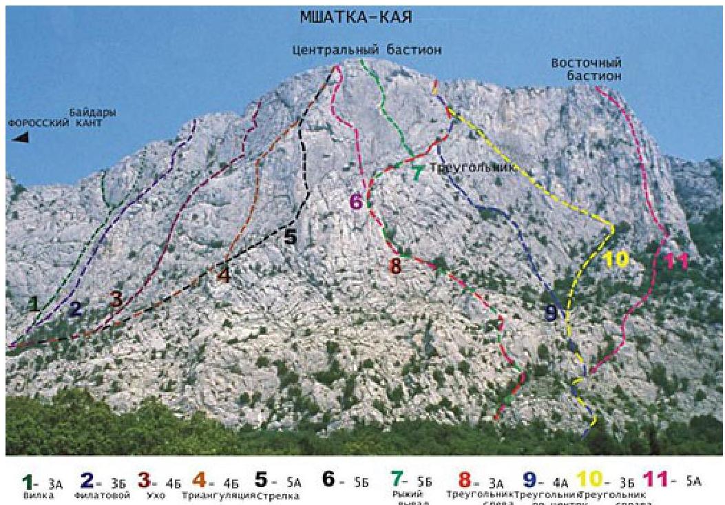
Mshatka-Kaya — category 17
Through the center of the "triangle" in the eastern part of the massif ("triangle in the center"), 4a (route by A. Volkodav and M. Bystritsky, 1973)
Between the Central and Eastern bastions, in the upper part of the wall, two long, oblique, interrupted shelves with trees form a large oblique angle, clearly visible from the road and referred to as the "Triangle". Below these shelves is a steep wall. In its center, a group of trees on a terrace is clearly visible. The route passes through the center of the wall to this group of trees, and then upwards and to the left — to a long shelf forming the left side of the "Triangle".
From the upper road, 30 m east of the fork to the main road and Foros settlement, ascend first along the trail, and then along the talus and simple rocks to a sloping terrace overgrown with bushes and trees, and along it to the central part of the wall (R0: 200 m, 30–50°, no category — I).
On the R1–R2 section — upwards 100 m through cracks and internal corners of the wall to the right part of the terrace with trees, located in the middle part of the wall. Overhanging rocks on the second rope are bypassed to the right (R1–R2: 100 m, 65–70°, III+).
On the R2–R3 section — first along the terrace 30 m to the left to its left edge. Then upwards and to the left 50 m along a steep, destroyed crack to a tree on a long shelf — the left side of the Triangle. (R2–R3: 30 m, 50°, 1; 50 m, 75–60°, 4–3).
Further, the route coincides with route #8. On the R3–R4 section — upwards and to the right along an oblique shelf to a wide internal corner (R3–R4: 50 m, 60–70°, 5).
On the R4–R5 section — upwards and to the right along simple rocks to the base of a steep internal corner (R4–R5: 40 m, 60°, 2).
On the final section of the route — upwards along the steep internal corner to the exit to the summit (R5 — summit: 40 m, 85°, IV+).
The length of the main part of the route is 310 m. The ascent takes 4–5 hours.