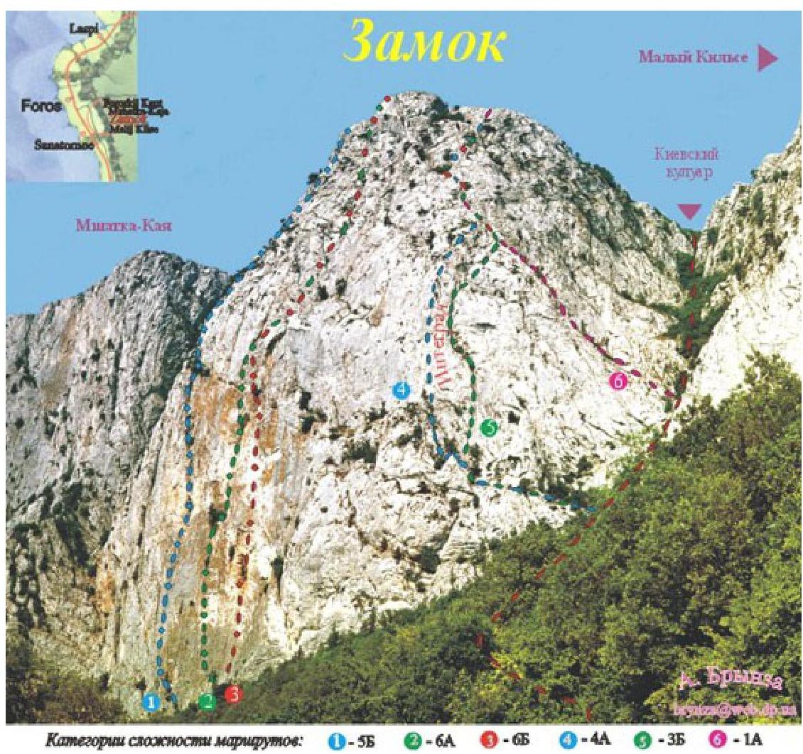
Castle
The Castle peak (650 m) rises several meters from the upper (old) road Yalta — Sevastopol near the village of Foros. To the left of the Castle is the Mshatka-Kaya mountain, and to the right is Maly Kilse-Burun. The most interesting routes on the Castle pass along the southern wall — these are the routes:
- 6A
- 5B
This is 8 ropes of the wall section, not counting the "roof". The length of the routes is about 400 m. On the more gentle southeastern wall, there are several relatively simple routes:
- 1B
- 3B
The southern wall of the Castle looms over the upper (old) road, which connected Sevastopol and Yalta for over 100 years. The steep wall with a smooth, mossy, and in some places overhanging lower part; a more gentle but crumbling upper part and several caves overgrown with ivy in the center — it inspires awe and trepidation. Three very complex routes have been laid out along it, serving as benchmarks for the highest level of climbing mastery:
- Route 1
- Route 2
- Route 3
On the more gentle southeastern wall, there are several relatively simple routes.
The approaches to routes №1, №2, and №3 start from the upper road (old Yalta — Sevastopol road), and to routes №4, №5, and №6 — from the middle part of the Kievsky couloir, located between the peaks of Castle and Maly Kilse.
You can ascend to the couloir via a path starting at the widening of the road east of the peak.
You can descend from the peak, which is a small elevation on the yayla, in several ways:
- Firstly, move west along the marked trail and descend onto the old highway above the Foros church;
- Secondly, down the steep Kievsky couloir;
- Thirdly, down the Bashi kuluar, located at the eastern edge of the highest peak in the area — Kilse-Burun. It is more convenient and safer for descent than the Kievsky.
| № | №1 | Name | |||||
|---|---|---|---|---|---|---|---|
| 1 | Chapa | 6A | 7a+ | 330 м | 3 | ||
| 2 | 1 | By corners of the left part of the S wall | 55 | VI, 350 м | A3 | 5 | |
| 3 | 2 | Sokoliny | 6A | 7a+ | VI, 370 м | A3 | 6 |
| 4 | 3 | Through the cave | 6A | 6c | 360 м | A2 | 13 |
| 5 | Direct-2003 | 6A | VI, 350 м | A3 | 16 | ||
| 6 | Riglos | 6A | 7c | 350 м | 17 | ||
| 7 | 4 | Reverse Integral | 35 | V, 300 м | 19 | ||
| 8 | 5 | Integral | 3A | V, 300 м | 20 | ||
| 6 | Kievskaya | 15 | II, 220 м |
- Along the left side of the central part of the southern wall, 5B (route by Yu. Lishaev (Fantik) and V. Tarasevich, 1977)
- Along the center of the southern wall (Sokoliny), 6A (route by Fantik, 1985)
- Through the cave in the central part of the southern wall (Through the cave), 6B (route by Fantik, 1986)
- Along the left edge of the bastion Integral (Reverse Integral), 4A
- Along the right edge of the bastion Integral (Integral), 3B (route by A. Grishkevich and V. Mironov, 1969)
- Along the center of the southeastern wall (Kievskaya), 1A
"Chapa" has nothing to do with Igor Chaplynsky; "sara" means "bolts" in Spanish. Approach the base of the couloir between the peaks of Castle and Mshatka. Ascend 20 m up the couloir; on the right, you can see an inscription in blue paint (CHAPA max. 7A+). It takes 5 minutes to reach the start of the route from the road. All protection points are colored blue. It's very easy to navigate as the route is constantly visible.
The first three ropes are relatively solid rock, but it gets worse further up, so you need to be careful. Most loose rocks have been removed, and many places have been cleaned of vegetation and earth.
The route was intended to be easier to climb, but it turned out to be more challenging due to the need to anchor to stronger rock. "CHAPA" can be climbed free, but many sections can also be done with artificial aids (ITo). It all depends on the climbers' level of preparation. It's recommended to bring various gear:
- relief skyhooks
- friends
- pitons
- nuts
A huge request: please don't drill new holes for skyhooks, don't hammer in your own pitons, and don't remove your nuts. :)
We really hope that the route will remain as it was originally created. In this case, it will remain interesting and visited by climbers.
The route was created from top to bottom between March 14 and 16, 2003. Then it was fully climbed free. Big thanks to 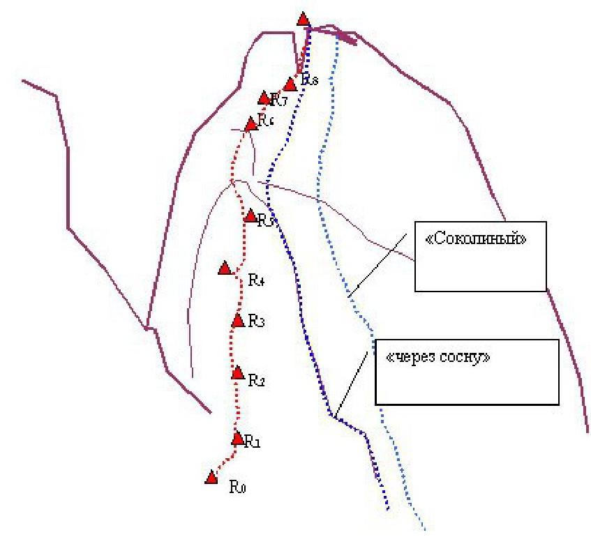
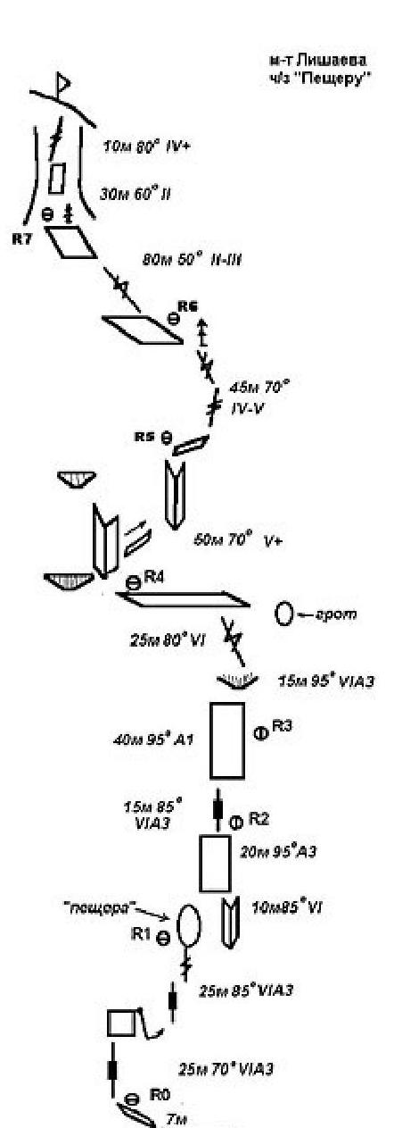
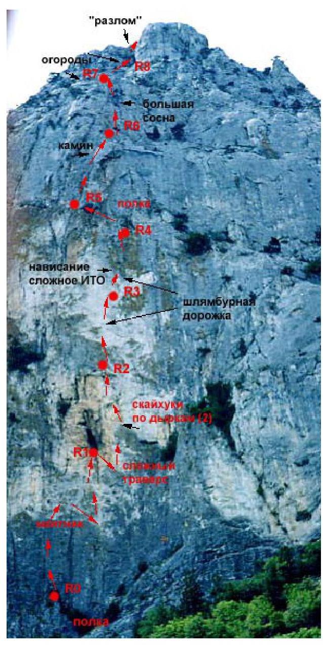
Fig. 2. "Topo" of the route "Chapa" on v. Castle. (Left part of the central wall along a pronounced bastion, left of the route "Through the pine tree") To Alexey Zhilin (Odessa) for the excellent perforator HILTI and to Sergey Natotchny (Simferopol) for long and thick bolted pitons.
R0–R1 — 3A, 25 m, 2 nuts; R1–R2 — 7A, 35 m, 7 bolts, 1 piton; R2–R3 — 6A, 30 m, 2 bolts, 2 slings on a tree; R3–R4 — 7A+, 35 m, 7 bolts; R4–R5 — 6B, 45 m, 7 bolts, 1 piton; R5–R6 — 5B, 30 m, 2 bolts, 1 piton; R6–R9
Cat. 2–3, move up with a slight deviation to the right towards the fracture in the summit tower. Up the fracture (there's a nut). These three ropes are relatively easy, but it's advisable to belay (there are trees).
The route length is 330 m. The category will be finalized after several ascents (as well as the ascent time).
4 R0–R1:
- Ascend simple rocks 10 m, approach the overhang.
- Through the overhang left and up, difficult climbing 10 m.
- Further along the groove overgrown with grass 10–15 m.
- Station left of the groove on a ledge — 2 bolts.
VI, A2, 35–40 m, 80°
R1–R2: Up the groove, exit to an internal corner 10 m, 80°, VI, then up the corner under the overhang. Station on large nuts. VI, 10 m, 80°+ III–IV, 30 m, 65°
R2–R3: From the station up the overhanging groove, exit to a tree, from the tree along a crack, difficult climbing, ITO, exit to an internal corner overgrown with ivy. Station on a bolt. VI, A3, 50 m
R3–R4: Up the corner, exit to a ledge with a large tree. Station. V, 40 m, 70°
R4–R5: From the tree left and up along a crescent-shaped internal corner, exit to gentle rocks on the "roof". Station on a tree. IV, 50 m, 60°
R5–R7: Along simple rocks up, in the direction of the left fracture of the summit tower. I–II, 100 m
R7–R8: Along the corner-fracture, exit to the yayla. III, 30 m 60°
Time: 5–7 hours.

R0–R1: From the tree up and left along simple, crumbling rocks 15 m, further up the groove, difficult climbing under the overhang 20 m, further on ITO along "deaf" grooves 10 m to the station (3 bolts) IV, A3, 45 m
R1–R2: From the station, difficult climbing right and up 10 m, further up towards the grotto, difficult climbing 10 m. From the grotto, difficult traverse right 5 m to a groove with crumbling edges. Up the groove, exit to a ledge with large trees.
- Difficult climbing right and up, 10 m
- Climbing up to the grotto, 10 m
- Traverse right to the groove, 5 m
- Ascent along the groove to the ledge with trees
VI, A2, 35 m
R2–R3: From the tree right 5 m and up the internal corner 10 m, then along an intermittent, deaf groove, ITO, partially climbing 15 m. Station on 2 bolts under the overhang.
- Move from the tree right, 5 m
- Ascent along the internal corner, 10 m
- Movement along the intermittent, deaf groove, ITO with climbing sections, 15 m
VI, A3, 30 m
R3–R4: From the station up and right — difficult climbing along an overhanging internal corner with loose rocks 20 m. Exit to a ledge. Along the ledge 5 m right. Station. VI, A2, 25 m
R4–R5: Up the internal corner 10 m, then right 8 m, and along the corner-chimney, exit to a ledge. Station on a bolt. V, 50 m
R5–R6: Along the ledge 5 m right, then up the groove with a large pine tree — exit to gentle rocks.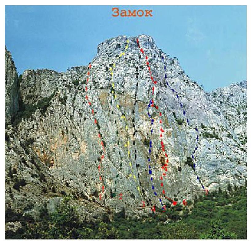
1: ? 5A 2: Geniush, Shcherbakov, 1994, 6A? route not repeated 3: Lishaev ? 5B 4: Lishaev ? 6A? route not repeated 5: "Sokoliny" Lishaev, 6A 6: "Through the cave" Lishaev, 1983, 6B 7: Voloshanovsky, 1992, 6A? route not repeated
Scheme UIAA route by Lishaev 6A
"Sokoliny"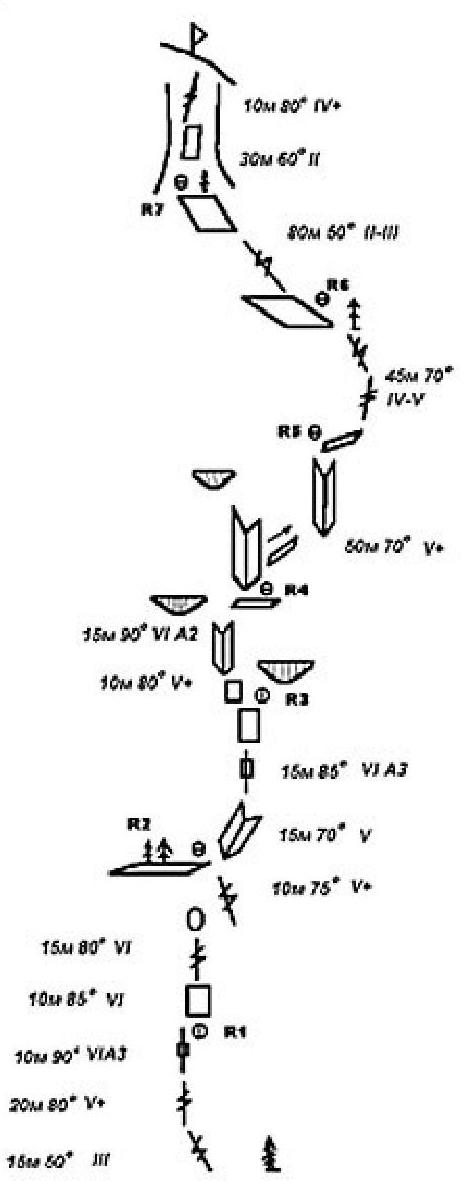
V — , 45 m
R6–R7: Along simple rocks, move in the direction of the large fracture. II, 80 m
R7–R8: Up the fracture, through a small overhang, exit to the yayla. IV+, 40 m
Time: 6–8 hours. Route №3 Sokoliny 6A, F7a+ (or VI, A3)
The route "Sokoliny" was first climbed 20 years ago — in 1985 — by Yuri Lishaev ("Fantik"). The line of the route beautifully and practically crosses the center of the steep wall of the Castle. In previous descriptions, the route was presented as 6A, VI. In January of this year (2005), we with Olga climbed "Sokoliny" free and would like to clarify its description.
We all climb and belay differently on rocks. And what's written in (gray brackets) should be considered as our subjective view on climbing and belaying on certain sections of the route. Perhaps these notes will be useful to someone. Protection on the route:
- friends
- nuts
- pitons
Occasionally, there are old pitons — sometimes with torn ears, and old bolts — usually no more than two per section and looking more like (stumps) from a rusty tin can.
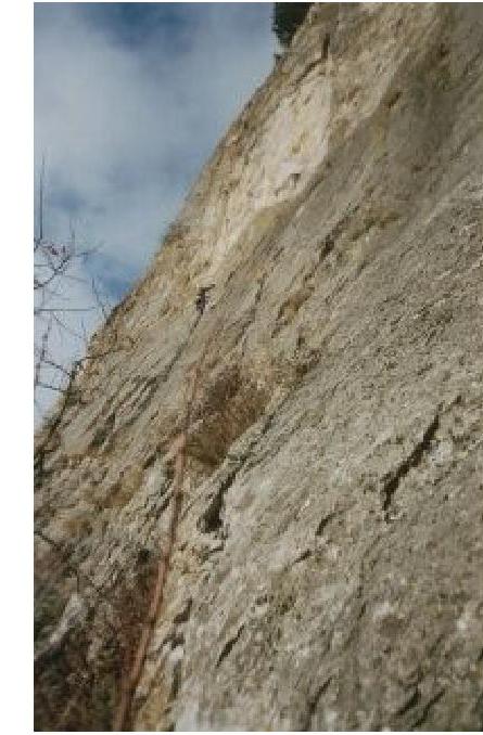
From the "upper" road, ascend through a copse and a low rock wall to a large "open" meadow under the southern wall of the Castle. The route "Sokoliny" starts directly under a well-noticeable cave located in the center of the wall.
R0–R1:
- From the trees under the wall, ascend simple, crumbling rocks left and up to a groove strongly overgrown with grass (III, 15 m).
- Up the groove to "whitish rocks" (5c/6a, 20 m) — an old bolt.
Climbing the groove is not difficult and is complicated only by the fact that it's heavily clogged with earth and grass. The groove is quite wide in some places — friends №4 fit well.
Further along "deaf" grooves and "shells" (another old bolt) left and up to the station (7a, 10 m).
Station on:
- two rusty bolts
- 12 mm Spit Petzl (hammered in 2000 by Lekha Osipov)
7a (obbl.* 6b+), 45 m (in previous descriptions VI, A3)
- obbl. — abbreviation for obligatory — mandatory level of climbing. On section R0–R1, difficult climbing starts about 10 meters before the station: previous climbers have significantly broken the rock in this area, making the existing "shells" on the wall even more pronounced, which greatly facilitates climbing. Therefore, before placing a friend or hammering a V-shaped piton, think about whether you're depriving yourself of a convenient hold. Good holds can be found on the right on the wall.
R1–R2: From the station up and right into the "right groove" (which groove is right can be understood on site).
Up the groove to a grotto (20 m). The grotto is not too high but quite deep and cozy.
From the grotto, traverse right and up (4–5 m) to a "crumbling" groove.
In the depth of the grotto, a piton is hammered and a long "motovku" is tied to it.
At 11.5 m after exiting the grotto, an old piton is hammered.
Up the groove to a ledge with trees (20 m). After ascending to the ledge, turn left to a large tree on which the station is located. 6B (mandatory 6A), 45 m (in previous descriptions VI, A2)
Caution! Loose rocks throughout the section!
First rope. On the approach to "whitish rocks". Marking №2 Sokoliny 6A, F7a+ (or VI, A3)
Relief in the middle of the third section.
R2–R3: From the tree along the ledge right to a crumbling internal corner. Up it to a "deaf", slightly overhanging groove (5c, 15 m). Up the groove to a slab — an old bolt with the inscription "Fantik" (7a+, 10 m). From the bolt up and slightly right to red "quite fragile" rocks. From them left back to the groove and up to the station under a large overhang (6a, 10 m). Station on three old bolts, plus a "carrot" hammered in the groove on the left.
7a+ (mandatory 6c/6c+), 35 m (in previous descriptions VI, A3)
The "deaf" overhanging groove is the key section of the entire route. To the left and right of the groove, there are not many holds, but they exist. Be careful — the rocks are quite "fragile" — my foothold on the left of the groove broke off. The groove is deaf, but you can organize intermediate protection without much difficulty.
Caution! Rocks in the lower and upper parts of the section are heavily destroyed!
R3–R4: From the station, slightly up and then through a crack left "overflow" onto the wall. Up the wall to a destroyed, wide groove, up which ascend to a depression under an overhang (6a/6a+, 15 m). In the groove, there are two bolts with the inscription "Fantik".
The overhang is passed in the right part — at the exit, there are a couple of old pitons (6c+, 5 m).
Further right and up along simple rocks (II–III, 5 m) exit to a station.
Here, the route "Sokoliny" connects with the neighboring route by Yuri Lishaev "Through the cave" 6A.
Recently, this route was restored by Odessans Alexey Zhilin and Vladimir Mogila, so starting from this station, new "sound" bolts Petzl will delight your eyes on each subsequent station.
- 6c+, 25 m (in previous descriptions VI, A2)
- Caution! Loose rocks on the section!
R4–R5: From the station up the internal corner 10 m, then traverse right and further up the large fracture right and up, exit to a small ledge. Station on bolts.
5b, 50 m (in previous descriptions V+)
Caution! Loose rock blocks on the section!
R5–R6: From the station:
- Right along the ledge and up to a small "crooked" pine tree,
- From it up the groove with a large and "slender" :) pine tree,
- Exit to gentle rocks in a huge bowl in the upper part of the wall.
Station on bolts.
5B, 45 m (in previous descriptions IV–V)
R6–R7–R8: Along simple rocks, move towards the large fracture that is directly above you. Stations on bolts. II–III, 90 m (in previous descriptions II–III)
You can approach the base of the fracture from both the left and the right. We approached from the left — it seemed easier.
Section R8–R9: From the station in the upper part of the fracture, ascend left and up to overhanging blocks and along them exit to the yayla. Station on bolts. 4c, 35 m (in previous descriptions
IV+)
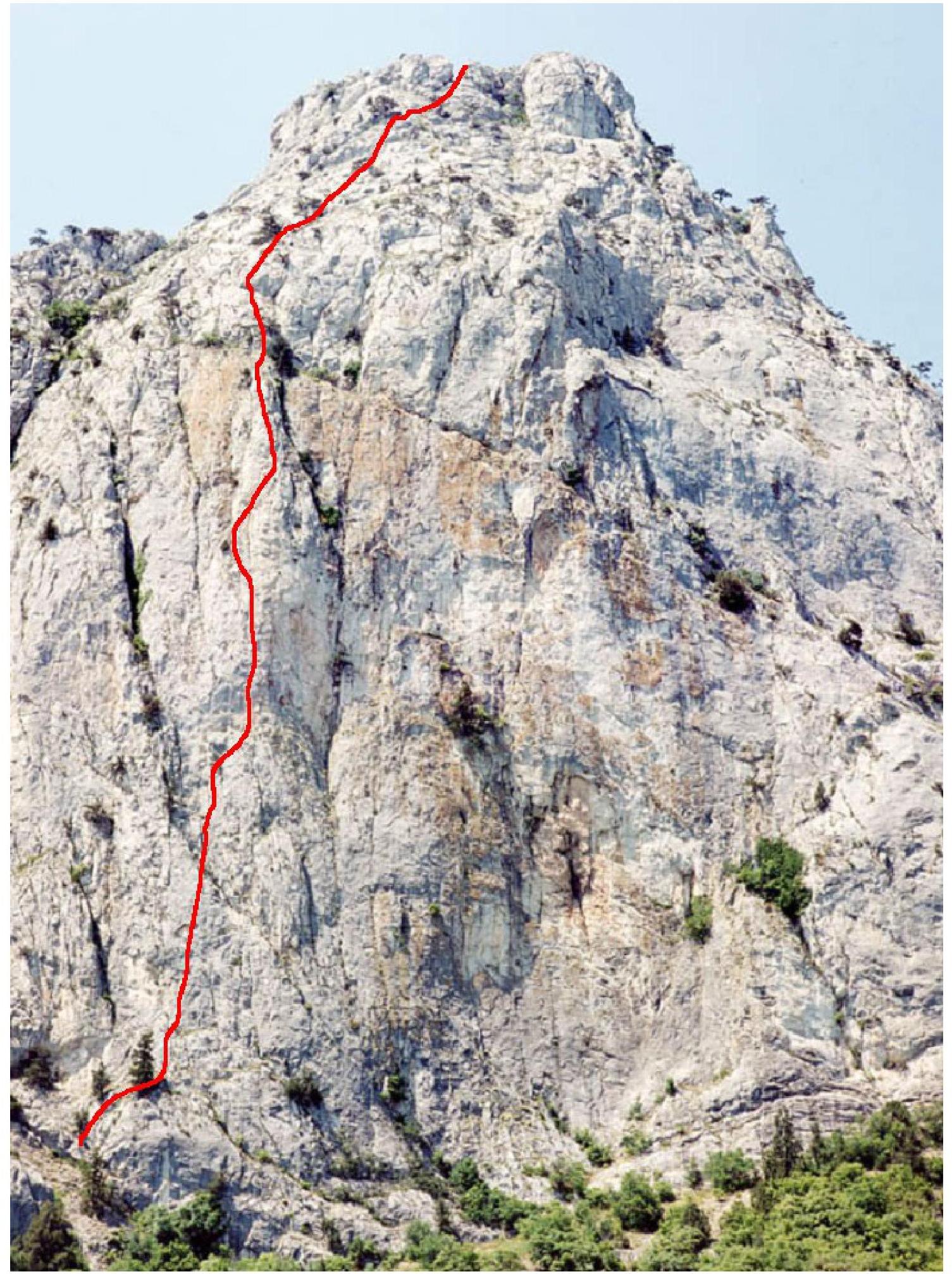
Crimea, g. Castle. Route "Sokoliny", 6A (route by Yu. Lishaev, 1985)
In April 2006, the bolted pitons on the route were replaced. Intermediate protection points were installed:
- "Kong" (d=10 mm, l=50 mm)
On stations R1 and R3, pairs were installed:
- "knocks" "Kong" (d=12 mm, l=90 mm)
- "Kong" (d=10 mm, l=50 mm)
The route passes through the center of the wall, along a groove that cuts through the Castle from bottom to top, and looks super mega-logical from afar. From the road, the abundance of vegetation on the route immediately catches the eye. The picture seems a bit unusual: the wall "stands", sometimes even overhangs, the grooves are vertical, there are no visible ledges with earth, and the grass is green...
- the wall "stands"
- sometimes even overhangs
- the grooves are vertical
- there are no visible ledges with earth
- the grass is green
If the route has not been climbed for a long time, its difficulty increases, and the ascent speed decreases accordingly.
In many places where you can climb free, you have to move on ITO, ruthlessly pulling out bushes and cleaning grooves from earth (after climbing each rope of the first bastion, the leader's entire outfit, gear, and face were covered in earth, and he looked more like a valiant miner).
But you have to clean, because behind the dense vegetation, there are excellent grooves for protection and holds, and, most importantly, it becomes visible where to put your feet, and the likelihood of dirtying your climbing shoes on the green is reduced. For this reason, I even developed several rules:
- When pulling out grass, especially from climbing, you should pull it down, not away from the wall, because when pulling out the next "strong" stem, you can fly off with it.
- It's essential not to get your hands dirty with sap, as they become very slippery.
- It's also crucial to blow away the earth that has accumulated on the ledges during weeding, because putting your feet on
dirt
This is what happened here
It was fraught. Sometimes a bush doesn't give in, and you have to rotate it until it cracks.
On belay
In one place (above the cave), I grabbed a protrusion with my hand and began to weed the greenery around it. After finishing the work, I experienced a strong feeling of fear when I saw that I was holding onto a loose rock that hadn't fallen only because I was pulling it down, not away from the wall. After the ascent, we walked along the road under the Castle to our tent. The changes on the wall immediately caught our eye.
- The vertical beds cultivated by the creator's generous hand had disappeared.
- The grooves seemed clean and pleased the eye.
Spring is probably the most unsuitable time for climbing the route. There's too much greenery, and it's very succulent. I think that in autumn or winter, when all this agrarian chaos dries out, it's easier to climb. But, without a doubt, it's best to go with a team, so to speak, following in fresh tracks.
Another negative aspect of the route is the abundance of "live" rocks. Compared to "Sokoliny", the routes "Chapa-Chapa" and "Through the cave" on the same mountain are much more pleasant.
Especially rich in this regard are:
- the second rope (entirely),
- the lower part of the third,
- the upper part of the fourth.
The rocks that flew from under me on the second rope flew dangerously close to the belayer, making Valentin strongly nervous and swear out loud. One rock still managed to hit him on the head, but a good helmet Grivel saved the day.
As we climbed the vertical piece, we peeked into all the grooves in search of the proud bird that gave the route its name, but we never met it. Either we're bad ornithologists, or the predator had emigrated to another area, but apart from snails and lizards, no one greeted us from the grooves...
For climbing the route, classic protection gear is necessary:
- nuts,
- friends,
- hexes,
- pitons.
No hatchets, planks, skyhooks, or other elements of "high ITO skills" are required.
Route №2 "Sokoliny" 6A, F7a+ (or VI, A3)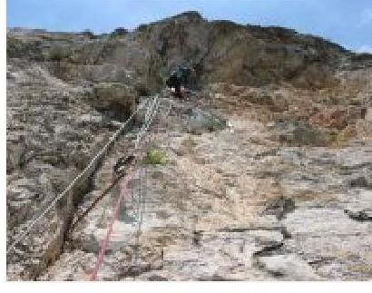
The good deed was brought to life thanks to the General (also Chief, Information, Equipment) sponsor of the project, the Kharkov Equipment Center "EXTREME", which provided:
- bolts;
- really cool gear from "Kong";
- "Millet";
- "Beal";
- "Grivel";
- "La Sportiva".
Castle, description of the route "Sokoliny", 6A. From the road, follow the path under the wall. Station on a tree growing on a small grassy ledge.
R0–R1: 10 m, II, 50 m, IV, 75 m, VI, 80–95 m, A2.
From the ledge left and up along simple, gentle rocks:
- 10 m — II,
- 5 m — IV, to the groove.
Up the groove:
- initially climbing,
- then on ITO to a bolt (25 m).
From it up another 10 m to the station.
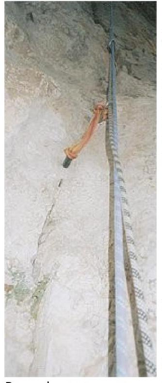
Station on two new "Kong" bolts (one of them is a cowinox) plus a spit. For blocking all points, it's better to take a long loop (180 cm). The station is hanging.
R1–R2: 45 m, VI, 90, A2. On this section, try not to drop "live" rocks on the lower climber.
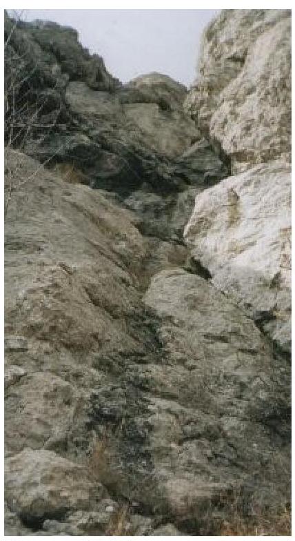
From the station, ITO up (piton) along the groove 5 m, then traverse 2 m to the right groove. Up it 5 m, traverse to the left groove 3 m. Along it, initially climbing, then ITO (piton) to the cave. In the cave, there's a bolt. There are old pitons on the section.
Russian climber Maxim Kostrov, who climbed "Sokoliny" in winter 2005 free, recommends:
- moving all the time along the right groove.
From the cave, traverse right through the wall to the groove (at the start of the traverse, there's a piton in the grass in the groove). Further up the groove, climbing, partially ITO. Many loose rocks. The last 3 m to the ledge are noticeably easier. Along the ledge, move left to a large pine tree. On it, there's a station. From this tree, it's convenient to rappel into the cave and to the previous station.
R2–R3: 20 m, V, 80; 20–25 m, VI, 90.
From the right edge of the ledge, move up and left along a crack. Initially climbing (20 m, V) to the end of the crack on the left. Many "live" rocks, grass.
Further ITO along the groove in the white limestone (large and medium-sized chocks, nuts) to a new bolt 10–15 m. Then another 3 m to the second bolt. From it right to the live crack 3 m, then traverse left to the main groove and along it ITO, with some climbing, 5–7 m, to the station.
Station under a huge overhang on two new "Kong" bolts (one of them is a cowinox). Old bolts are left as a monument to the first ascender and for contrast.
R3–R4: 25 m, VI–VI-, 85–95.
From the station:
- Up the internal corner 4 m,
- Then "overflow" through the ridge left to a bolt,
- From it up to a large crack,
- Along it to a bolt (3–4 m),
- Further — under the overhang,
- Pass the overhang on the right (there are 2 pitons) and exit left onto simple rocks,
- Along them, move right and up to a ledge with bolts.
Here, the route connects with the route "Through the cave", where stations are equipped with fresh bolts by V. Mogila and A. Zhilin.
Protection:
- pitons
- hexes
- friends
R4–R5: 45 m, V, 80. Up the internal corner 15 m under the overhang, then traverse right 8 m to a crack, along it to a ledge.
R5–R6: 40 m, V–, 75. From the ledge right 5 m, then up through a tree along a groove towards a large pine tree. You can make a station on it, or you can climb 5–7 m further to a bolt.
R6–R7: 45 m, II, 45–50. Along simple rocks towards a pine tree under a small wall-overhang.
R7–R8: 40 m, III+, 65. From the pine tree left and up along small walls to a bolt and a pine tree.
R8–R9: 45 m, III, 65. From the station up 15 m, then left and up to a tree. Before the tree, there are small walls.
R9–R10: 40 m, IV, 80. Up the internal corner, then exit along a ledge left 3 m and up along small walls to a ridge. Along it right to two bolted pitons.
Authors: Poltavets Evgeny, Sipavin Valentin (team EC "EXTREME" Kharkov). R0–R1: Along an inclined, overgrown with bushes ledge left and up 7 m. Bolt. From the bolt up along a groove, initially climbing 5–8 m, then on ITO exit to a bolted "road". Along bolts right 8 m, then pendulum right 5–7 m to a bolt. From the bolt right and up along a deaf groove on ITO 10 m, further climbing, exit to a grotto. Station. VI, A3, 55 m, 80°
R1–R2: From the station, descend and move right to an internal corner. Along the corner, then along the wall, exit to a bolt. From the bolt up along an overhanging wall on ITO (skyhooks, small nuts, pitons, there are bolts) 10 m, then climbing, exit to a station. VI, A3, 30 m, 90°
R2–R3: From the station up on ITO along an intermittent, deaf groove, exit to a bolted "road". Along bolts up. Station on 3 bolts. VI, A2, 40 m, 90°
R3–R4: Along bolts approach a small overhang. Through the overhang on ITO (piton, skyhook, small nuts) 15 m, further climbing, exit to a ledge. Along the ledge left 10 m. Station.
- VI
- A3
- 50 m
- 80°
R4–R7: Further, the route coincides with "Sokoliny". Time: 9–11 hours.
On November 17, 2023, Vladimir Mogila with Alexey Zhilin (Odessa) finished "repairing" the route by Yuri Lishaev ("Fantik") "Through the cave".
"...We did the main work three weeks ago, and this time we just put the finishing touches. We didn't redo or change the route; we just tried to restore it."
- Equipped reliable stations.
- Replaced some old bolted pitons. Removed unnecessary ones.
- Cleaned the route from old pitons and nuts.
- Cleaned from "live" rocks as much as possible.
For stations, they used "PETZL" pitons. Typically:
- "Batinox" (diameter — 14 mm, depth — 11 cm, two-component glue)
- "Long Life" (12 mm, 6.5 cm)
"Batinox" can be used for rappelling. In case of rescue operations, you can quickly descend from the yayla. Most intermediate bolted pitons are bolts (CASSIN) (10 mm, 7 cm). On "roads", they replaced every other one. On the second rope, most intermediate ones are "PETZL" (Colinox) (10 mm, 7 cm).
They hammered in two additional pitons:
- at the start of the first rope (dangerous section above the ground)
- in the middle of the fifth (dangerous section above a ledge)
The station in the cave was moved slightly to the right out of the cave (to reduce rope friction on sharp rocks).
On the first three ropes, there's a possibility of rappelling with a single 50-meter rope:
- on the first — an additional rappel station 20 meters below the cave
- on the second and third — rings in the middle of the sections
Brief description by sections:
On the photo, numbers are not shown. I think you can figure it out without them. Classification according to UIAA (i.e., 11 categories of climbing difficulty with "+" and "−", and 5 categories for ITO). See Comparative table of rock climbing difficulty categories
- R0–R1 85 m, VI — A1, VII+/A2, 45 m
- In the middle of the rope, a traverse to the right ends with a pendulum to a parallel groove.
- R1–R2 95° VI A2 38 m
- R2–R3 95° VI– A2 48 m
- R3–R4 50° II 15 m
- Traverse left along the ledge.
- R4–R5 70° V 40 m
- R5–R6 75° IV 40 m
- R6–R7 45° III 70 m
- Starts with a gentle 30-meter section.
- R7–R8 45° II 35 m
- R8–R9 75° IV– 30 m
![img-15.jpeg]({"width":1321,"height":2084,"format":"J