Report
On the first ascent
to Takhtarvumchorr Central peak (1143 m) via the right part of the E wall, category 5A (proposed), by a team from St. Petersburg from June 17, 2023, to June 18, 2023.
Climbing Passport
| 1. General Information | ||
|---|---|---|
| 1.1 | Full name, sports rank of the team leader | Andrey Olegovich Panov, Master of Sports |
| 1.2 | Full name, sports rank of the participants | Oksana Andreevna Kochubey, Candidate for Master of Sports |
| 1.3 | Coaches | Tatyana Ivanovna Timoshenko, Vladimir Aleksandrovich Molodozhen |
| 1.4 | Organization | RSOC Federation of Alpinism of St. Petersburg |
| 2. Characteristics of the Climbing Object | ||
| 2.1 | Area | 8.4.1. Takhtarvumchorr ridge |
| 2.2 | Valley | Poyasov cirque |
| 2.3 | Section number according to the electronic Russian classifier of routes to mountain peaks | 8.4.1 |
| 2.4 | Name and height of the peak | Takhtarvumchorr, Central (1143 m) |
| 2.5 | Geographical coordinates of the peak (latitude/longitude), GPS coordinates | N 67.66881° E 33.52761° |
| 3. Characteristics of the Route | ||
| 3.1 | Route name | via the right part of the E wall |
| 3.2 | Proposed category of difficulty | 5A (proposed) |
| 3.3 | Degree of route exploration | first ascent |
| 3.4 | Terrain of the route | rocky |
| 3.5 | Elevation gain of the route | 313 m (830 m above sea level → 1143 m above sea level) |
| 3.6 | Route length (in meters) | 350 m |
| 3.7 | Technical elements of the route (total length of sections of varying difficulty with indication of terrain type (ice-snow, rocky)) | 2–3 cat. diff. rocky — 65 m, 4 cat. diff. rocky — 40 m, 5 cat. diff. rocky — 115 m, 6 cat. diff. rocky — 130 m (including A2 artificial aids — 115 m) |
| 3.8 | Average steepness of the route, (°) | 71° |
| 3.9 | Average steepness of the main part of the route, (°) | 71° |
| 3.10 | Descent from the peak | Via the NE spur of Takhtarvumchorr S. (Use of mountaineering equipment is not required) |
| 3.11 | Additional characteristics of the route | |
| 4.1 | Time of movement (team's travel hours, in hours and days) | 12 hours, 1 day |
| 4.2 | Overnight stays | – |
| 4.3 | Route preparation time | – |
| :--: | :--: | :--: |
| 4.4 | Start of the route | 19:00 June 17, 2023 |
| 4.5 | Arrival at the peak | 07:00 June 18, 2023 |
| 4.6 | Return to the base camp | 10:00 June 18, 2023 |
| 5. Meteorological Conditions | ||
| 5.1 | Temperature, °C | 0 °C – +10 °C |
| 5.2 | Wind speed, m/s | calm |
| 5.3 | Precipitation | no precipitation |
| 5.4 | Visibility, m | 10000 m |
| 6. Person responsible for the report | ||
| 6.1 | Full name, e-mail | Andrey Olegovich Panov aopanov@gmail.com |
General route photo Photo 1
- 5A Andreev, 2004
- 5A Murin, 2015
5A Panov, 2023
photo date: June 17, 2023 coordinates: 67.67134, 33.53757
Drawn route profile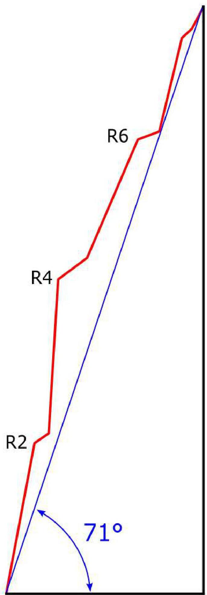 Area panorama (from Google Earth)
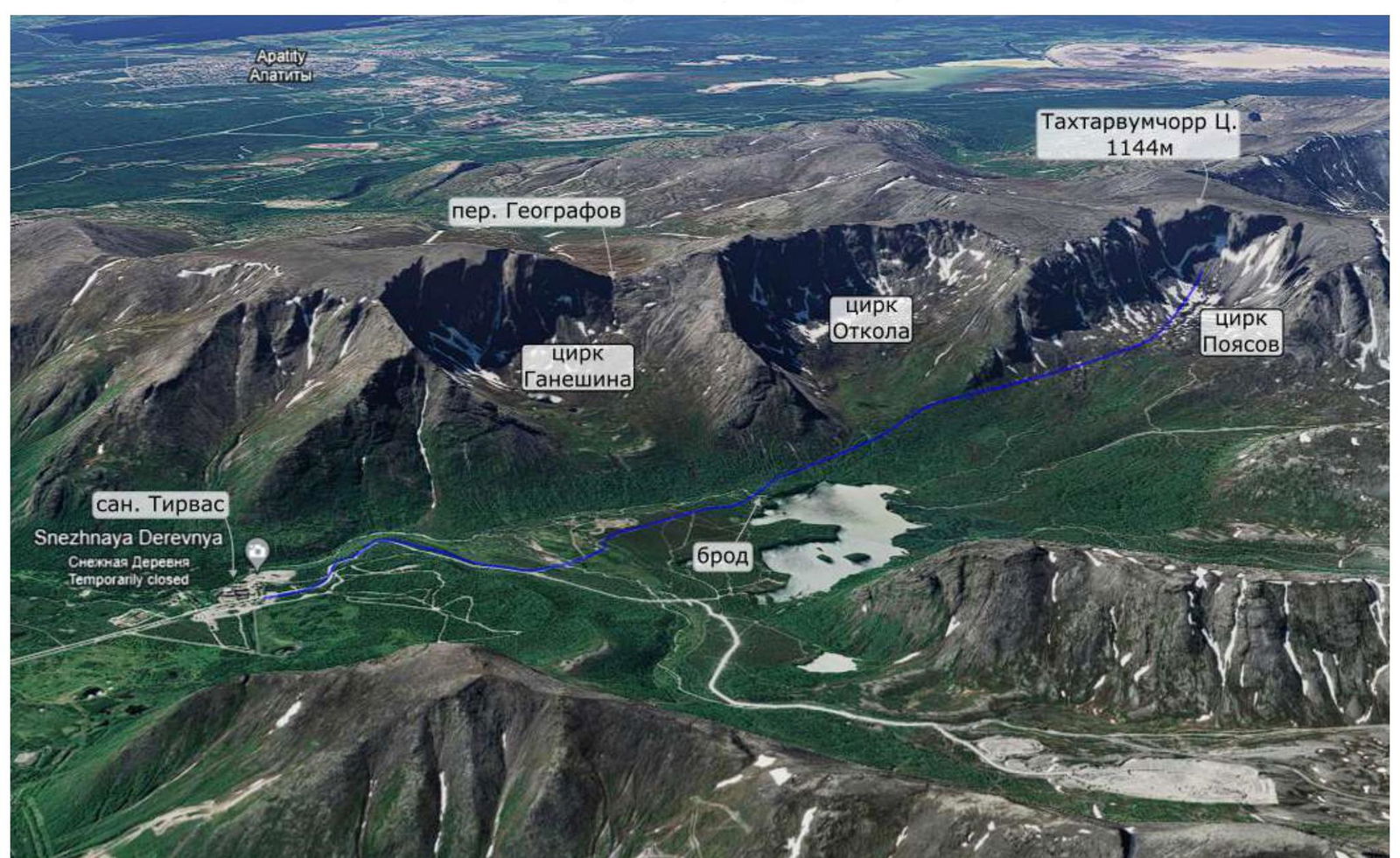 Area map
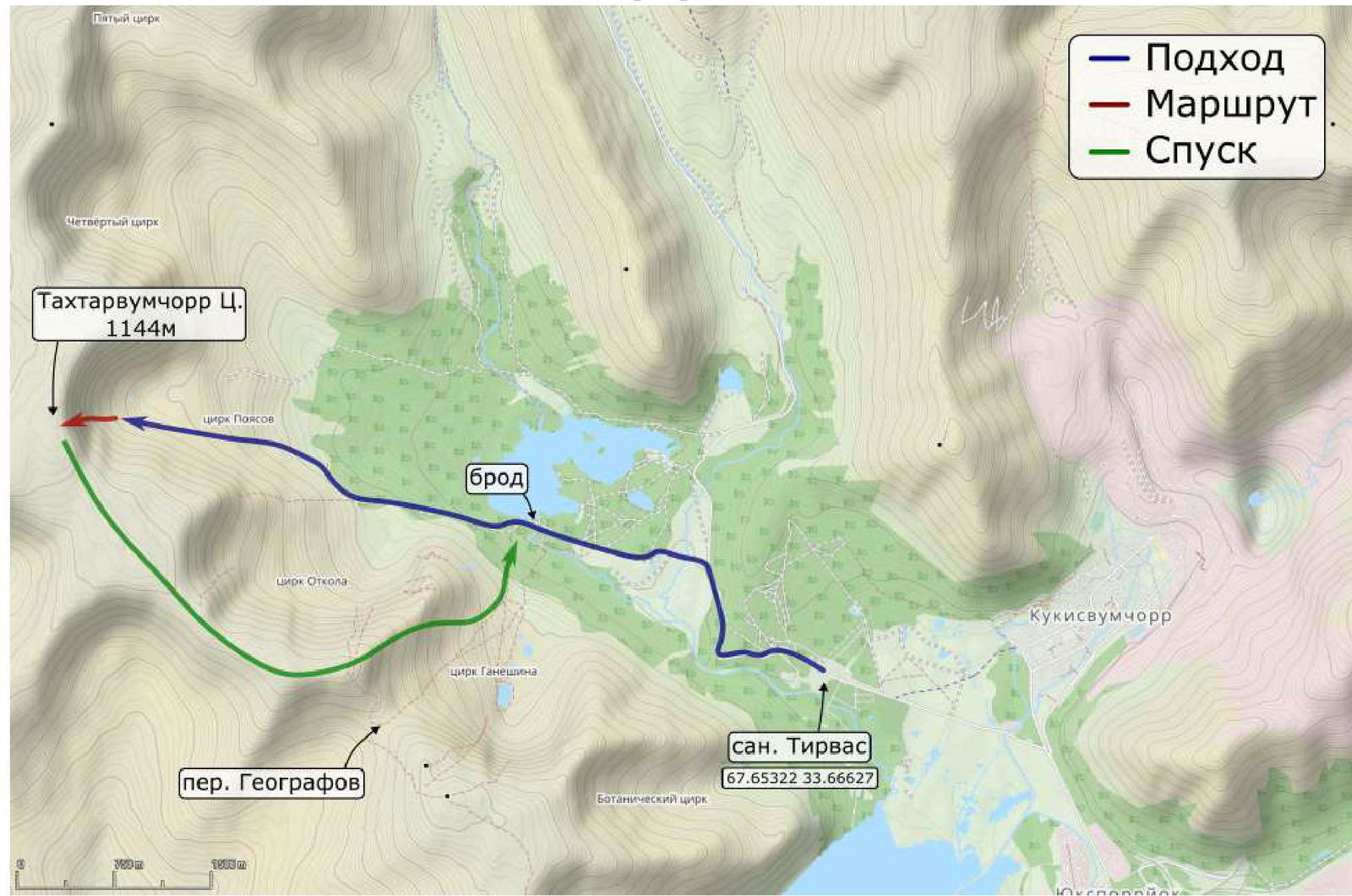
Area Description
The Takhtarvumchorr Central peak (1144 m) is located in the Khibiny mountain range.
The peak is a ridge with not very pronounced peaks. The southern slopes are forested and gentle. The northern and eastern walls are steep and cliffy. The northern sides form several large cirques, interesting for mountaineers — "Otkola" cirque (SE cirque), "Poyasov" cirque (E cirque), and others.
The route is located in the "Poyasov" cirque. This cirque is relatively under-explored by mountaineers due to its remoteness.
The team climbed a route on the E wall of the Poyasov cirque. Currently, two 5A category routes are classified on the Poyasov wall:
- Murin's route (2015)
- Andreev's route (2004)
Our route passes through the same part of the E wall of the Poyasov cirque, slightly to the right of Murin's route.
Approach
From the "Tirvas" sanatorium (67.65291, 33.66829), move along the road to the northwest. Turn left (67.66089, 33.64434), and continue along the dirt roads to the ford at the source of the Vudyavryok river (67.66378, 33.61267). Then follow the road to the spur between the Otkola and Poyasov cirques. The road ends here (67.66527, 33.58027). Continue on foot along the rocky scree and snow talus of the Poyasov cirque to the start of the route. The landmark is a white cornice; the route begins 20 m to the right.
R0–R1 (35 m: 15 m 5, 20 m 6) The start of the route is via a moss-covered inner corner, 20 m to the right of the white cornice. Initially, 15 m of climbing, then on artificial aids.
R1–R2 (40 m: 25 m 6, 15 m 3) Continue on artificial aids through the inner corner. Reach a large scree-covered ledge, move 5 m left along the ledge to the next corner (with a series of cornices).
R2–R3 (35 m 6) Up the corner on artificial aids, through a small cornice.
R3–R4 (40 m: 20 m 6, pendulum, 20 m 5) Continue upward on artificial aids, overcome the second cornice. At the top of the corner, the path is blocked by the third cornice, the crack in the inner corner disappears. Make a pendulum left from under the cornice, move to more gentle terrain, and reach the second scree-covered ledge.
R4–R5 (40 m: 15 m 2, 25 m 5-) Move 15 m right along the ledge, then climb via the right wall of a destroyed chimney.
R5–R6 (45 m: 20 m 4, 15 m 5+, 10 m 2) Up the chimney; at the top, the chimney narrows, reach the third ledge. Move 10 m right along the ledge and go around the corner.
R6–R7 (40 m: 15 m 6, 25 m 5) Initially, on artificial aids up the wall, then climb via a large inner corner.
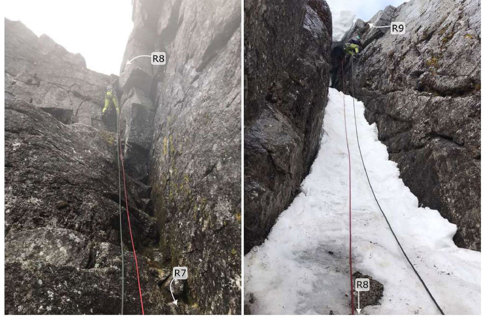
R7–R8 (30 m: 15 m 4, 15 m 6) At the top, the corner ends with a small wall — climb to a ledge at the base of a small snow couloir.
R8–R9 (40 m: 15 m 3 40° snow, 15 m 5+, 10 m 1) At the beginning of summer, there is snow in the couloir — with overhanging snow cornices at the top. Initially, on snow, then on the right wall of the couloir, reach the plateau. On the plateau, there is no terrain, making it difficult to organize protection.
Descent
From the peak, descent is possible either southward towards the Geografov pass (67.64955, 33.58452, ~3 km across the plateau) or northward along the spur (67.67747, 33.53778) between the Poyasov cirque and the fourth cirque.
Route scheme in UIAA symbols
| Section | Length | Steepness | Difficulty | Friends | Anchors |
|---|---|---|---|---|---|
| 8–9 | 10 m | 10° | 1 | 0 | 0 |
| 15 m | 75° | 5+ | 2 | 0 | |
| 15 m | 40° | 3 | 1 | 0 | |
| 7–8 | 15 m | 80° | 6 | 3 | 1 |
| 15 m | 50° | 4 | 3 | 0 | |
| 6–7 | 25 m | 60° | 5 | 3 | 0 |
| 15 m | 75° | 6 | 4/4 | 2/2 | |
| 5–6 | 10 m | 30° | 2 | 1 | 0 |
| 15 m | 70° | 5+ | 2 | 1 | |
| 20 m | 60° | 4 | 3 | 0 | |
| 4–5 | 25 m | 60° | 5- | 3 | 2 |
| 15 m | 25° | 2 | 1 | 0 | |
| 3–4 | 20 m | 65° | 5 | 4 | 3 |
| 20 m | 85° | 6 | 5/5 | 3/3 | |
| 2–3 | 35 m | 85° | 6 | 7/7 | 5/5 |
| 1–2 | 15 m | 40° | 3 | 2 | 0 |
| 25 m | 80° | 6 | 5/5 | 3/3 | |
| 0–1 | 20 m | 80° | 6 | 4/4 | 3/3 |
| 15 m | 60° | 5 | 2 | 0 |
Team actions
The team arrived in the area as part of the "Polytechnic" gathering (St. Petersburg). Oksana Kochubey worked as the safety officer for the second part of the gathering.
After the gathering ended, the team decided to climb a new route in the "Poyasov" cirque. There was little time left before departure, but the white nights allowed for a climb at any time of day, so it was decided to start the ascent in the evening.
We approached the route around 18:30 on June 17, 2023. The intended route line was clearly visible, but the rock was wet. We climbed in a lightweight style, without a bivouac, using the Krasnoyarsk scheme of simultaneous movement.
The route can be conditionally divided into 4 sections ("belts"), separated by well-defined ledges. The first and second belts presented the greatest difficulty.
We started work on the first belt at 19:00; the first corner was overgrown with moss, requiring manual cleaning and removal. By 21:30, we reached the ledge between the first and second belts.
We chose a line through the inner corner with a series of cornices, moving mainly on artificial aids. The corner was also moss-covered. The higher we climbed, the wetter the rock became due to melting snow cornices on the massif. Small streams began to flow down the rock. The second belt took about 3.5 hours; by 01:00, we reached the ledge above the second belt.
The third belt was more gentle, but the rock was heavily destroyed. We moved upward with careful climbing. At the top, we passed a wet chimney; by 03:30, we reached the base of the fourth belt.
The fourth belt began with a sheer wall, then the terrain became more gentle, but steep walls appeared from time to time. Before reaching the plateau, there was a snow couloir with frozen snow. We had to cut steps with an ice axe (the leader wore rock shoes); the last snow cornice was bypassed on the right wall. By 07:00, the team reached the peak.
Safety assessment of the route. Recommendations for subsequent climbers.
The route represents a logical, well-defined line tied to the inner corners on the wall. Some sections of the route reach 80–90°, with poor terrain, moss-covered corners, and constantly wet rocks, greatly limiting free climbing. Anchors and rock cams placed well.
Orientation on the route is not difficult, tied to natural terrain features, and fully corresponds to the route description.
Organizing protection on the route is sometimes complicated due to the terrain consisting of blind cracks without micro-relief. All protection stations on the route are in safe locations.
The first and second belts, approximately 4 rope lengths, present the greatest difficulty. The rocks are wet, with blind cracks, moss in the cracks, etc.
In conditions of the polar day (summer), it is possible to climb the route at any time of day. There is no water on the route.
Descent from the peak without mountaineering equipment. Emergency exit from the route: via the ascent path.
Equipment recommendations:
- a set of stoppers
- anchor pitons
- rock cams
- rock shoes
Photo report
Photos 2–3 Photos 4–5
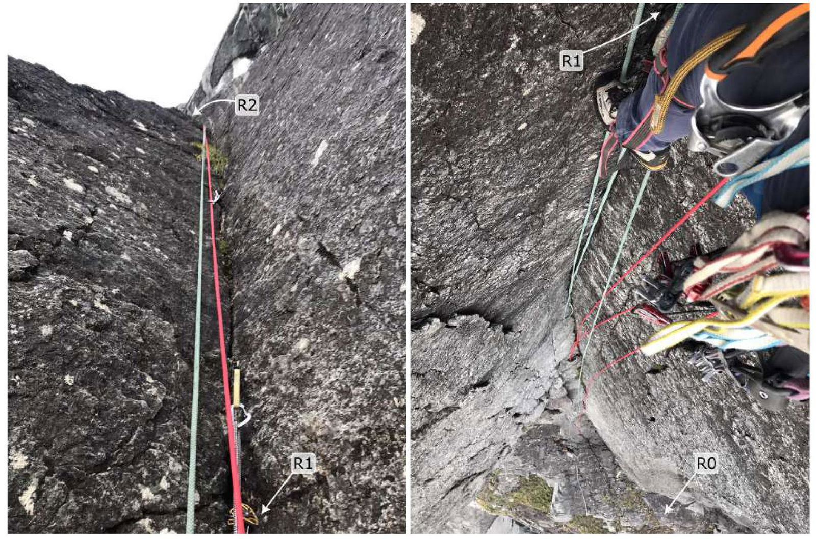 Photos 6–7
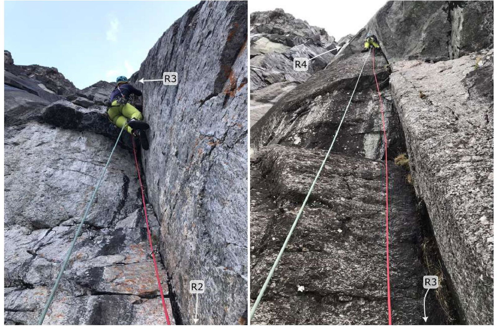 Photos 8–9
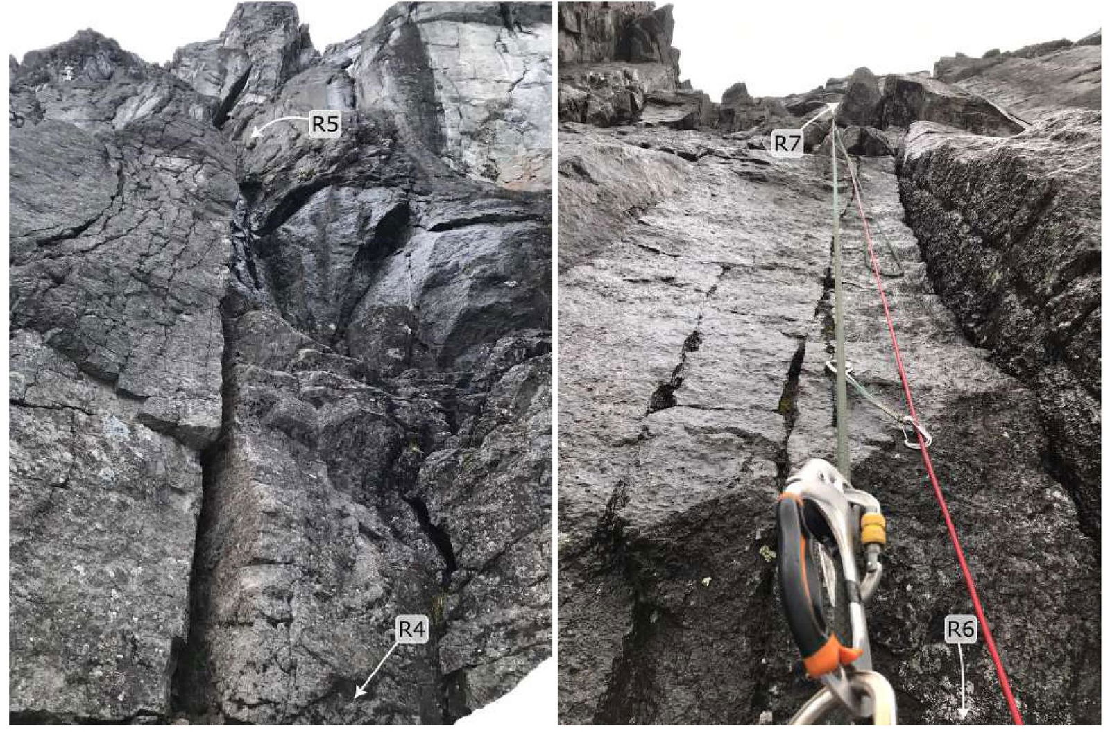 Photos 10–11