Report
On the Ascent
via the right part of the counterfort of the East wall bastion in Takhtarvumchorr (C) (1144 m), 4B–5A category of difficulty. Khibiny. Takhtarvumchorr Ridge
Leader: A.V. Yurkin Coach: A.V. Yurkin
Ascent Passport
- Kola Peninsula. Khibiny mountain massif. "Poyasov" Cirque. Classification table section number: № 8.6. (according to KGBM 2013)
- Name of the peak — Takhtarvumchorr Central (1144 m), route "Golfstream", via the right part of the counterfort of the E. wall bastion.
- Proposed category of difficulty — 4B–5A
- Route type: rock
- Height difference of the route: 315 m
Route length: 420 m. Average steepness:
- main part of the route — 77°;
- entire route — 60°.
Length of sections with V category of difficulty — 97 m, VI category of difficulty — 74 m.
- Number of "hooks" used on the route:
Anchor hooks: 10 pcs. Friends and chocks: 49 pcs., including bolted: 0.
- Team's climbing hours: 13 hours (not including descent)
- Leader: Yurkin A.V. Master of Sports.
Participants: Beschastnova Yu.V. 2nd sports category
- Coach: Yurkin A.V.
- Exit to the route from the base camp:
Route started: 05:15 August 14, 2013. Reached the summit: 18:15 August 14, 2013. Returned to base camp: 21:00 August 14, 2013. Descent from the summit: via the plateau towards "Otkola" cirque and then along the E. spur of Takhtarvumchorr to the valley of Maly Vudyavr lake.
- Organization: CSKA named after Demchenko
- Responsible for the report: A.V. Yurkin.
Email: S2_aleks@mail.ru
General Photo of the Summit
E. Takhtarvumchorr C (1144 m)
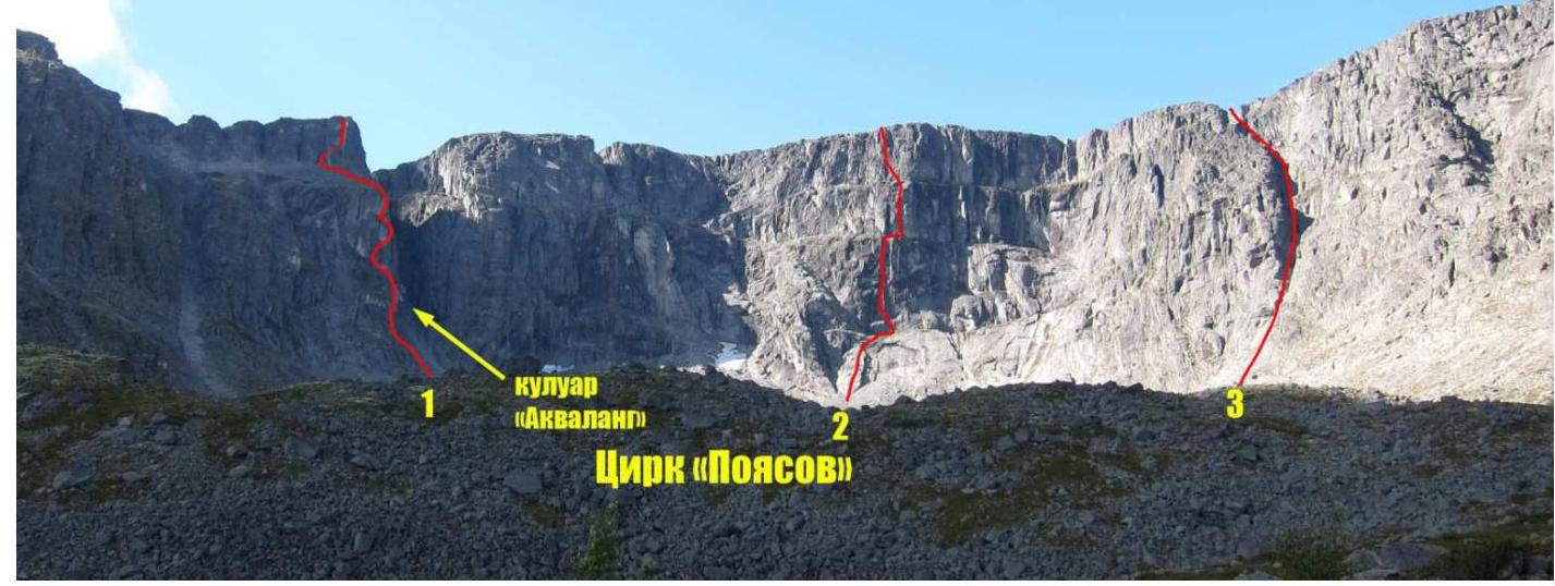
Photo of Takhtarvumchorr peak. Taken from the lower part of the plateau in "Poyasov" cirque on August 13, 2013. Classified routes on Takhtarvumchorr C peak:
- team's route (submitted for classification);
- route via the center of "Poyasov" cirque wall, 5A category of difficulty (A. Andreev, 2004);
- route via the "zigzag" couloir of E. wall of "Poyasov" cirque, 2A category of difficulty (O. Shumilov, 1992).
Map-Scheme of the Ascent Area
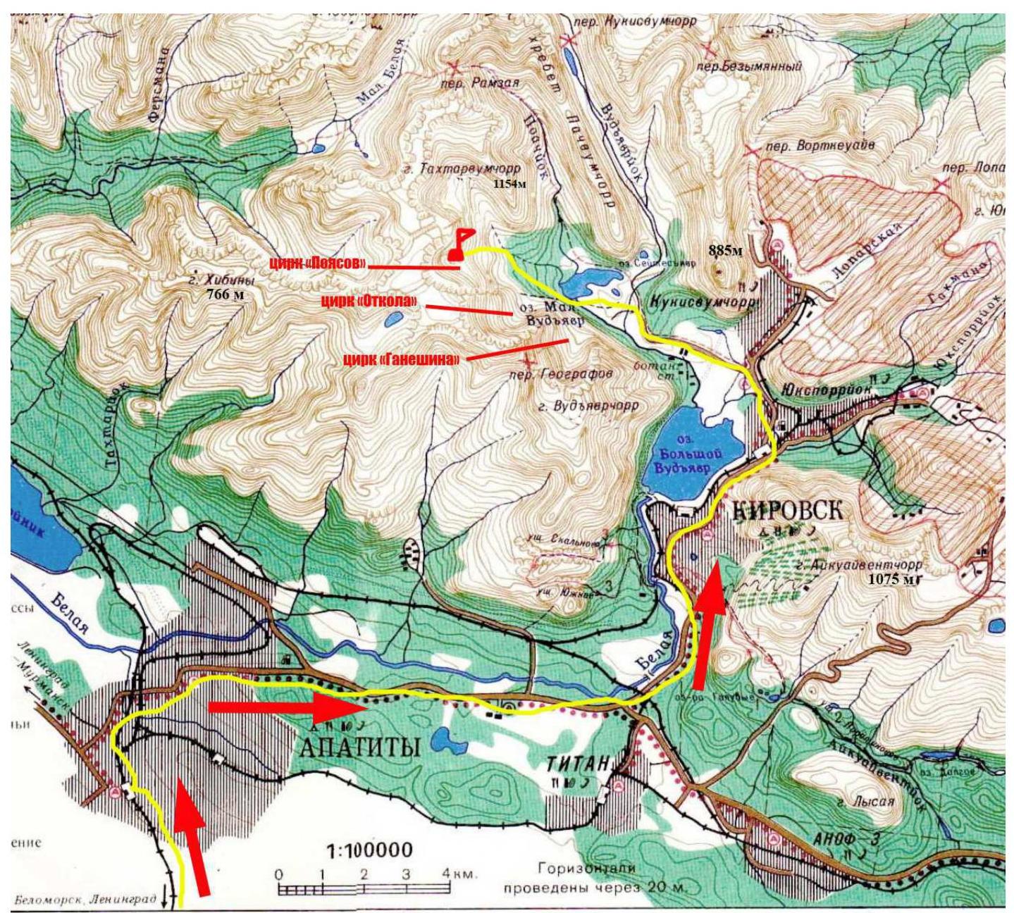
Map-scheme of the team's approach route to the base camp in "Poyasov" cirque
The Takhtarvumchorr peak (1144 m), which was the destination of the ascent, is located in the Khibiny mountain massif area. The peak itself is a ridge with not very pronounced summits. The southern slopes of the mountain are forested and gentle. The northern and eastern walls are steep and abrupt. The northern sides form several large cirques, interesting for climbers — "Otkola" cirque (SE cirque), "Poyasov" cirque (E cirque), and others.
The route is located in "Poyasov" cirque. This cirque, compared to other cirques of Vudyavchorr and Takhtarvumchorr, is still relatively undeveloped in terms of mountaineering due to its relative remoteness.
The team laid out the "Golfstream" route on a previously unascended bastion of the Eastern wall, left of the "Akvalang" couloir.
The approach to the cirque was made on foot from the "Tirvas" sanatorium (about 6 km) in 2 hours 30 minutes, along the left side of Maly Vudyavr lake (from the side of Vudyavchorr and Takhtarvumchorr ridges).
The bivouac was set up near a small lake under the wall of "Poyasov" cirque.
Route profile photo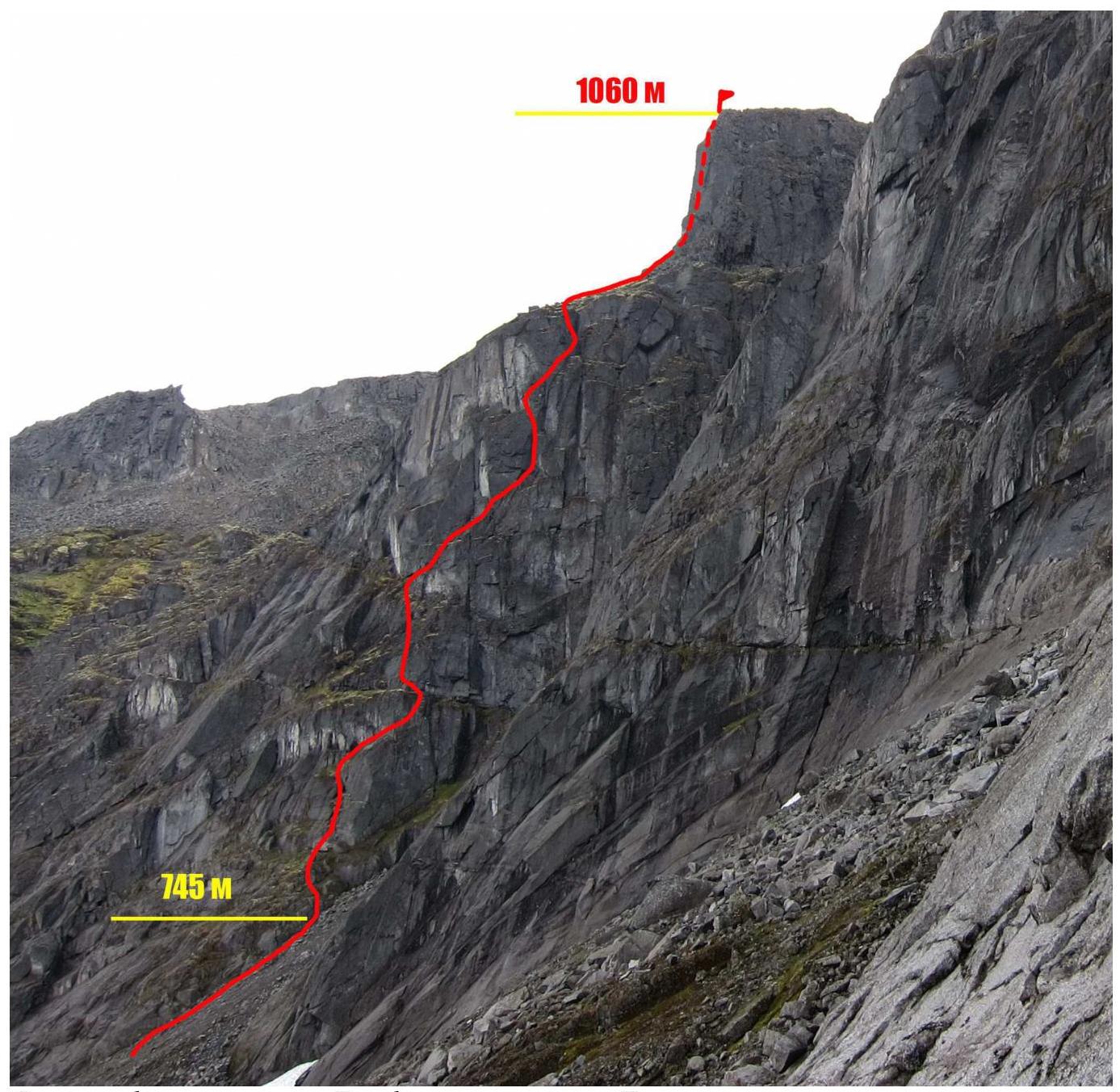
Photo of the "Golfstream" route profile from "Poyasov" cirque. Route scheme in UIAA symbols 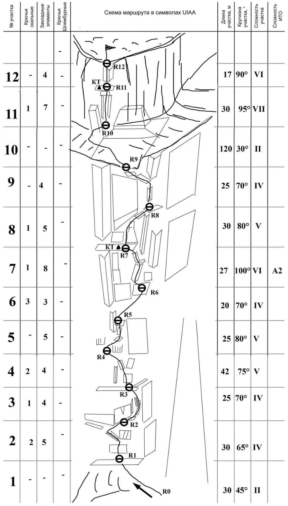
Technical Photograph of the Route
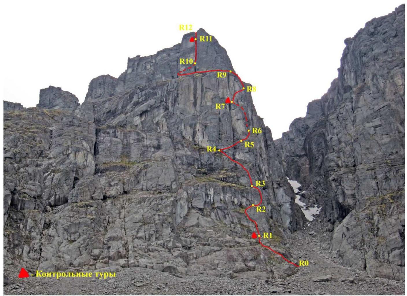
Brief description of the route passage by sections.
The approach from the bivouac near the small lake under the wall takes 30 minutes. Climb up the scree towards the large "Akvalang" couloir until the beginning of the large smooth inclined slabs at the base of the wall.
R0–R1: Up to the left via simple mossy rocks to a large ledge with boulders. 30 m, 45°, II.
R1–R2: Up via a large crack (15 m) to a grey wall with vertical cracks, then traverse 2–3 meters along a horizontal crevice to a small internal corner. Then up to the left via inclined ledges to the beginning of the wall, here to the right to a large convenient ledge under an overhanging wall with a crack. 30 m, 65°, IV.
R2–R3: Traverse to the right 5 m along the ledge around the corner and then up to the right via an inclined ledge to an internal corner. Bypass the corner to the right to reach a small chimney. Climb up the chimney and to the left via a ledge to a large standalone boulder. Convenient place for a station under an overhanging wall. 25 m, 70°, IV.
R3–R4: From the station, first straight up via complex rocks (20 m), then to the left up via small smooth internal corners. Much friction climbing. Protection on this section is mainly on anchor hooks. Convenient station under an overhanging rock with large blocks. 42 m, 75°, V.
R4–R5: Small traverse (5 m) to the right around the corner via blocks and then up via oblique inclined ledges under the base of a huge internal corner. Station to the right of the internal corner. 25 m, 80°, V.
R5–R6: To the right up around the corner via an oblique inclined ledge. Much friction climbing. Climb to the beginning of a large overhanging internal corner. Station made to the right of the internal corner (anchors). 20 m, 70°, IV.
R6–R7: Return back to the internal corner, crawl under the beginning of the overhanging corner via a good crevice. Climb up via the crevice (15 m). Middle-sized cams (0.5; 1) and chocks go well here. After passing the crevice, climb to a small ledge, then move up via a vertical crevice to the left up to a ledge under a huge internal corner. Control point № 1. 27 m, 100°, VI, A2 (6c French).
R7–R8: From the station straight up via the left edge of a large flat crack (15 m). From the top of the crack, traverse to the right up (2 m) and exit to an oblique inclined ledge. Along it to the base of a large mossy internal corner. Station on a ledge under a plug made of a large boulder. 30 m, 80°, V.
R8–R9: Up via the internal corner, bypass the plug and then up via a crevice to a fork. (!!! To the right is an overhanging "rotten" internal corner — not recommended to climb!) Climb to the left via a series of inclined ledges to the "roof" of the wall part of the bastion. 25 m, 70°, IV.
R9–R10: Climb up via scree to the summit tower to its left part. Route landmark — a huge vertical dihedral internal corner in the center of the wall. Before the wall, there is a large crack; bypass it to the left via a passage between the crack and the main wall. There may be loose rocks in the passage! Station on a small ledge at the base of the wall. 120 m, 30°, II.
R11–R12: Straight up via a wall made of large blocks to the beginning of a double internal corner. Then stick to the left side. It's more convenient to climb via the left crevice. Spreads, wedging of legs and arms. Inside the crevice, there are sometimes good holds. In the upper part of the corner, before an overhanging plug, move to the left side and transfer to the outer side of the wall. Voluminous "3D" climbing of 6a–6b level. Then via a small wall to a good ledge, here is a control point (laid in a horizontal large crack). Attention — there are loose blocks! With a rope of 55–60 meters, you can move further to the summit. 30 m, 95°, VII.
R11–R12: Up via large-block slightly overhanging terrain to the exit to the summit plateau. 17 m, 90°, VI.
Descent from the summit: on foot via the plateau towards "Otkola" cirque and then along the E. spur of Takhtarvumchorr to the valley of Maly Vudyavr lake. It's necessary to descend into "Otkola" cirque quite low, optimally to the remains of an old tractor. (!!! Moving to the left above and thus cutting the path is dangerous — rockfall and slippery "ram's foreheads"). From the summit to the campsite on the lake in "Poyasov" cirque — 2 hours.
Recommendations for the Route and Safety Assessment of the "Golfstream" Route
The route, initially planned via a series of vertical huge internal corners, was eventually laid out a bit to the side and around them, as climbing these corners would significantly increase the route's difficulty and time. Due to the detours, the line is almost entirely free-climbed (given dry weather). In case of rainy and wet weather, the route's difficulty significantly increases, as there are many sections that are climbed on friction, so one must be prepared to switch from free climbing to artificial technical climbing (ITC). For summer equipment, the following are necessary: a set of chocks, cams (friends), and anchors (or thin hooks), and extension slings. All belay stations on the route are located on convenient ledges and under the protection of overhangs. Stations are set up on their own points. Some sections of the route were specifically shortened, as many bends are formed, which interfere with the first climber's work. In the summer season, under the conditions of the polar day (end of June — beginning of August), it's possible to work on the route around the clock. Emergency descent from the route — under the summit tower, via a large ledge, there are exits to the summit plateau after 200–300 meters; a second option — via the ascent route. In the winter season, crampons and ice tools are required for the route. There's a risk of avalanches from the "Akvalang" couloir!
Photo Illustrations of the Report

Overview photograph of "Poyasov" cirque and perspectives. Taken from the lower part of the route on "Poyasov" 5A category of difficulty on August 12, 2013.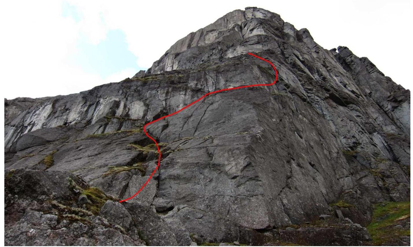
Photograph of the lower sections of the "Golfstream" route (R1–R3). Taken from the "Akvalang" couloir.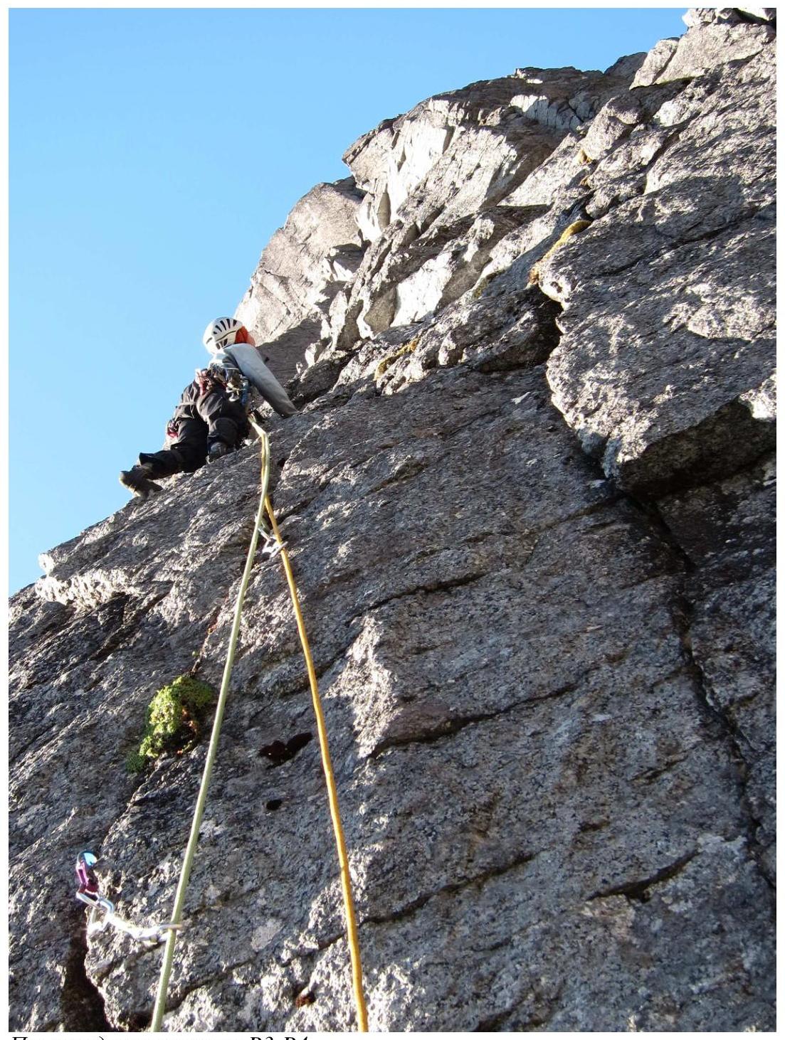
Passage of the R3–R4 section.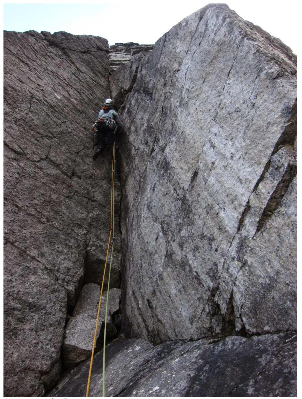
R6–R7 section.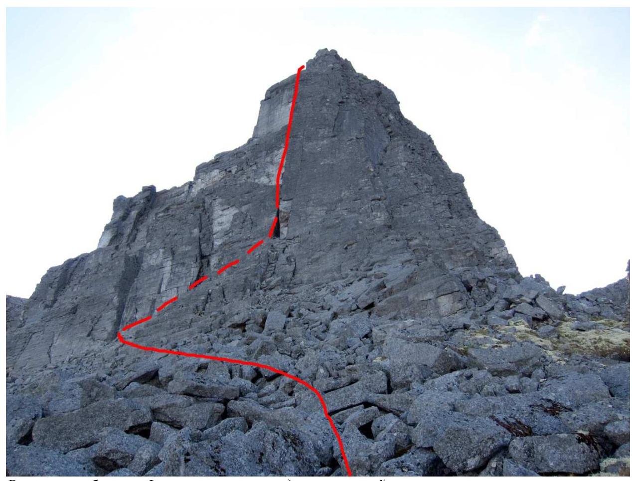
Summit tower. Photo taken from the exit point of the wall part.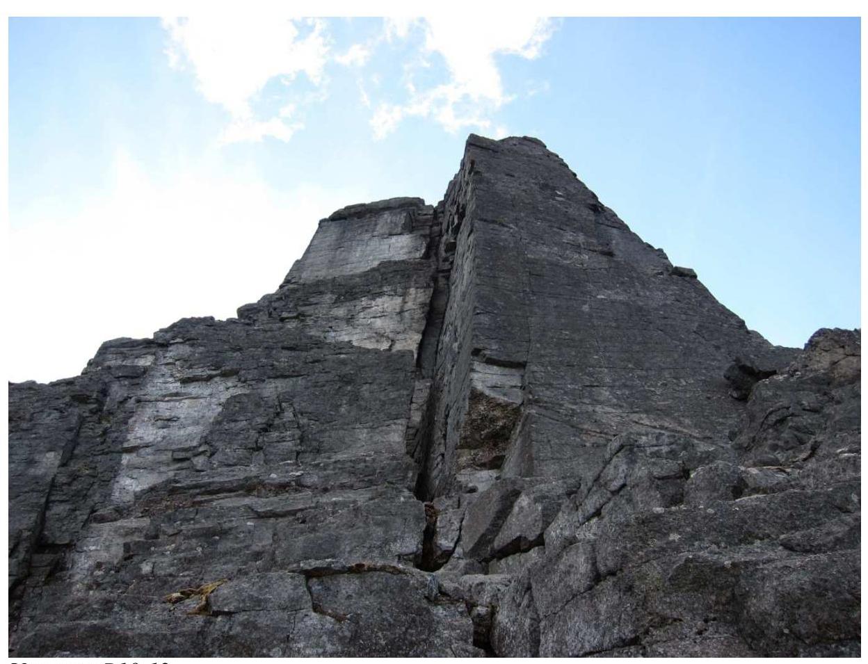
R10–R12 sections.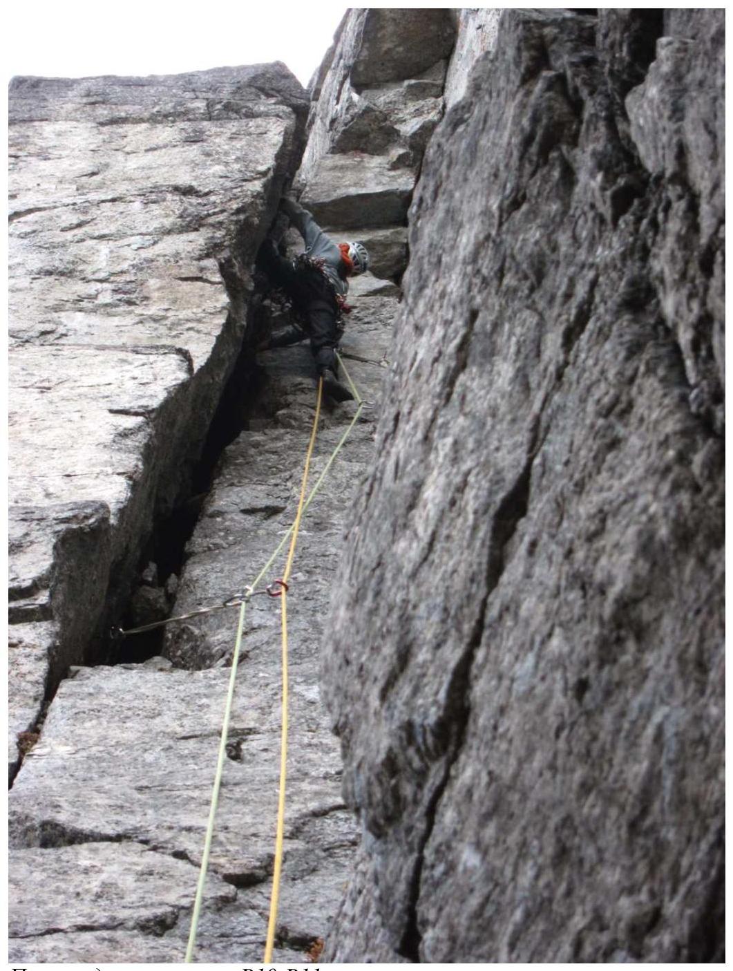
Passage of the R10–R11 section.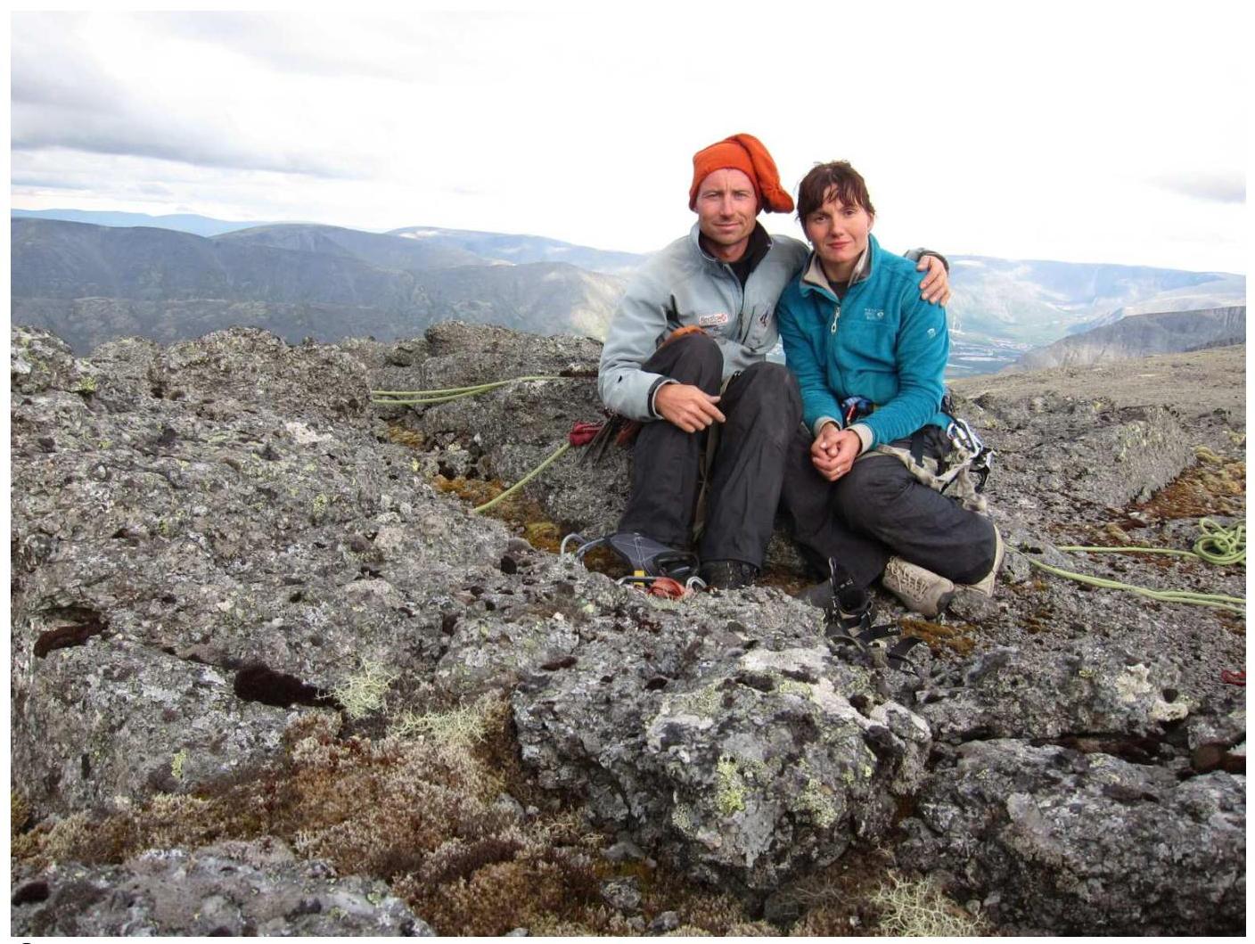
Photo at the summit.


