FEDERATION OF ALPINISM, ROCK CLIMBING AND ICE CLIMBING OF SAINT-PETERSBURG, "LETI" ALP CLUB
Report
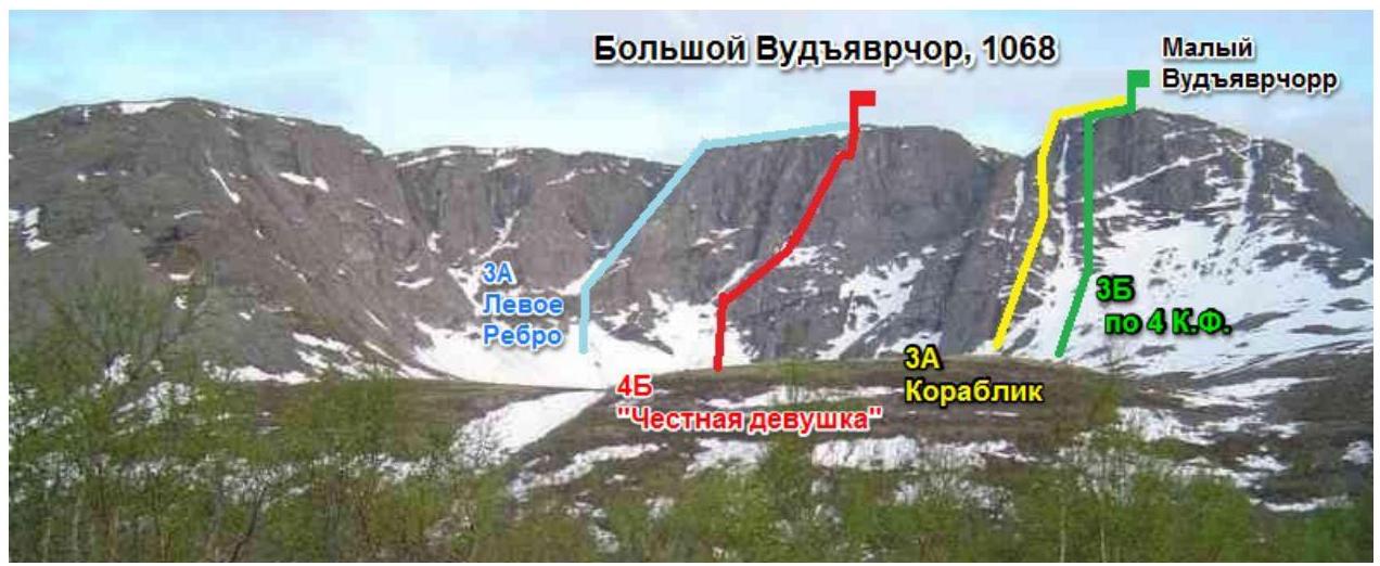
on Mt. Bolshoy Vudyavrchorr (1068 m) via the left part of the right bastion of the eastern wall "Chestnaya devushka" (First ascent was made on April 27, 1993, led by Shumilov O.I.)
Balagurin S.O.
Khibiny mountain range. Takhtarvumchorr ridge
Classification table section: #8.6
- Kola Peninsula. Khibiny mountain range. Takhtarvumchorr ridge. Classification table section: #8.6
- Peak name — Mt. Bolshoy Vudyavrchorr 1068 m, route name — via the left part of the right bastion of the eastern wall "Chestnaya devushka".
- Proposed category: 4B. First ascent
- Route characteristics: winter — combined, summer — rock.
- Height difference: 550 m
Route length: 950 m. Section lengths:
- Category I: 350 m
- Category II: 110 m
- Category III: 130 m
Category IV: 240 m, Category V: 91 m. Average steepness of the main part: 70°
- Number of pitons left on the route: total — 0; including bolted pitons — 0.
Total number of artificial protection points (APs): 3.
- Team's total climbing time: 12 hours.
- Team: leader — Balagurin S.O. — 1st category
Petrov S. — 2nd category
- Coach: Timoshenko T.I. — Master of Sports
- Departure from base camp: 8:15, June 10, 2013.
Reached the summit: 20:20, June 10, 2013. Returned to base camp: 21:30, June 10, 2013.
Descent from the summit:
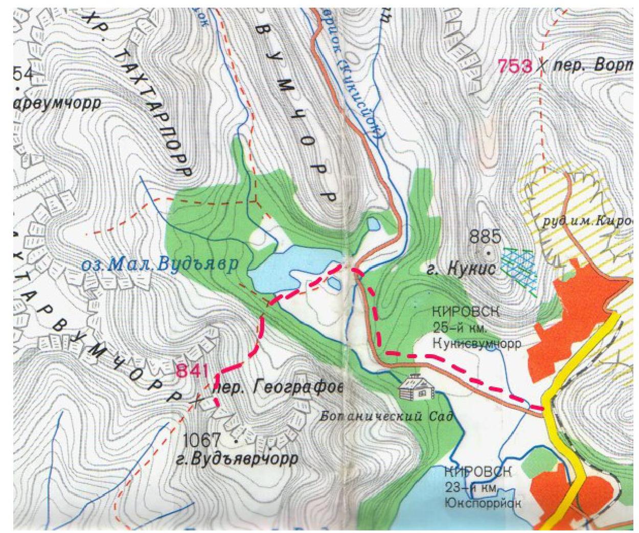
- via the western slope to the Geografov pass, then through the pass to Lake Maly Vudyavr,
- or through the Avalanche couloir.
-
Organizing body: Federation of Alpinism, Rock Climbing and Ice Climbing of Saint-Petersburg. "LETI" Alp Club
-
Responsible for the report: Balagurin S.O. Email: skin128@yandex.ru, phone: +7 963 740-75-54. General summit photo
Time and place of shooting: 9:00, June 9, 2013, Mt. Vudyavrchorr (B)
Route profile
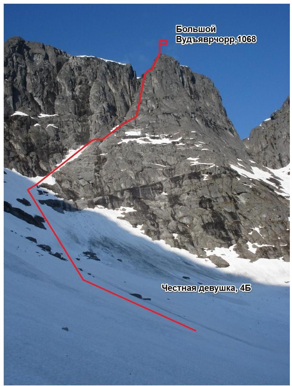
Time and place of shooting: 9:00, June 9, 2013, Mt. Vudyavrchorr (B)
Panorama of the climbing area.
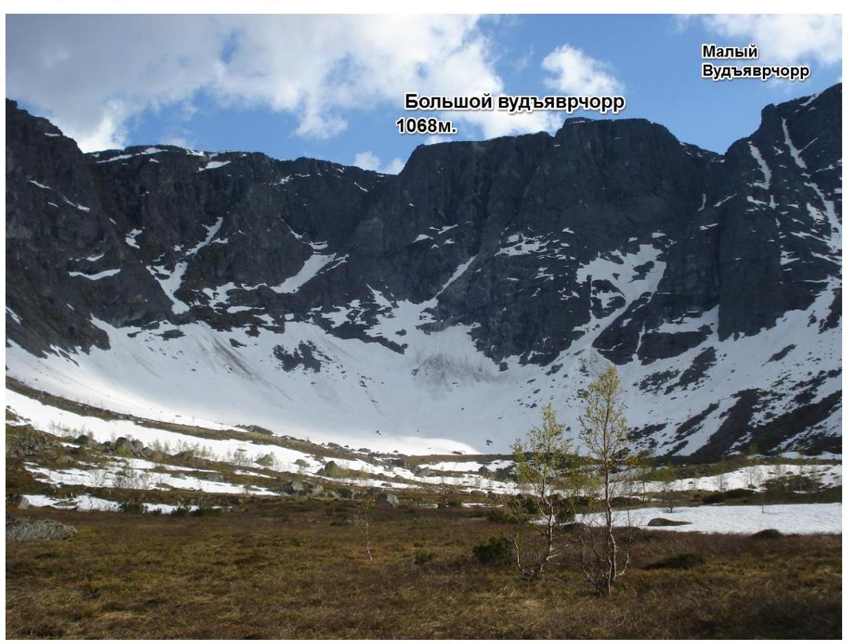
Time and place of shooting: 9:00, June 9, 2013, Mt. Vudyavrchorr (B)
Climbing area map
Route sections
| Section | Length | Steepness | Terrain description | Category | Number of pitons |
|---|---|---|---|---|---|
| R0–R1 | 350 m | 50° | Ascent via a stone scree (in winter — snow slope, possible ice, firn) | I–II | 0 |
| R1–R2 | 50 m | 30° | Via a crack | II | 0 |
| R2–R3 | 60 m | 20° | Via a crack along the wall on the left | II | 0 |
| R3–R4 | 40 m | 40 | Via a crack, partially turning into a chimney | III | 0 |
| R4–R5 | 40 m | 60° | Up the rocks with a traverse to the right towards a couloir | III | 0 |
| R5–R6 | 40 m | 70° | Through a couloir groove to the right | IV | 0 |
| R6–R7 | 40 m | 70° | Via smooth rocks (small holds, almost no cracks for pitons) along the ridge | IV | 0 |
| R7–R8 | 40 m | 80° | Along the ridge under the wall | IV | 0 |
| R8–R9 | 30 m | 80° | Via the wall (10 m, 85°, Category V). Exit to a wide ledge under an overhanging rock (chimney) 20 m, 70°, Category IV. | IV–V | 0 |
| R9–R10 | 50 m | 80° | Along the ledge to the right 20 m, then via the wall (20 m, 80°, Category IV) — exit to a ledge. Via the next wall (10 m, 90°, Category V+) to a ledge. | IV–V+ | 3 |
| R10–R11 | 46 m | 90° | Via the wall (10 m 90° Category V) to a ledge. Then via rocks (15 m 80° Category IV) and the wall (6 m 90° Category V) exit to a ledge. Along the ledge to the left 10 m and through the wall (5 m 90° Category V) exit to the ridge. | IV–V | 0 |
| R11–R12 | 50 m | 90° | Along the ridge | V | 0 |
| R12–R13 | 40 m | 60° | Up the pre-summit ridge | III | 0 |
| R13–R14 | 35 m | 65° | Via two walls 20 m 60° Category III and | III | 0 |
| rocks 15 m 70° Category III exit to a ledge. | |||||
| :-- | :--: | :--: | :-- | :--: | :--: |
| R14–R15 | 40 m | 70° | Up a crack | III+ | 0 |
| R15–R16 | 40 m | 60° | Via the wall (4 m, 80° Category IV) through a ledge (5 m) and a chimney — move left up via broken rocks (30 m, 40° Category II) exit to the summit (plateau). | III | 0 |
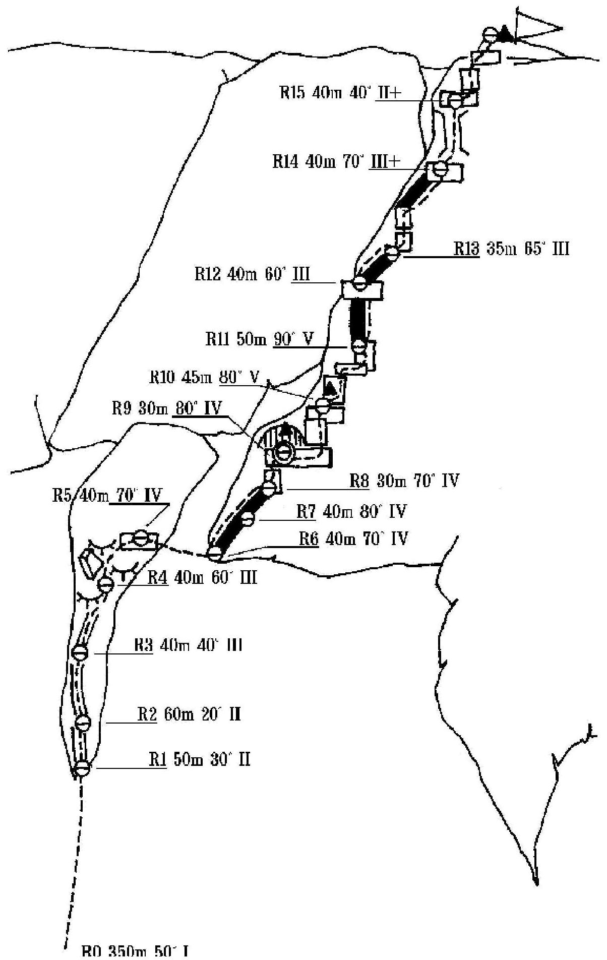
R13 35 m 65° III
Route description
On June 10, 2013, at 8:15, we departed from the base camp on the shore of Lake Maly Vudyavr. Approach to the Ganesha cirque.
R0–R1: ascent via a stone scree (in winter — snow slope, possible ice, firn) 350 m, 50° under the rocks of the counterfort on the left of the Avalanche couloir.
R1–R2: via "ram's foreheads" 50 m, 40° Category II. Rocks are almost always wet. R2–R3: to the right along a small ledge under the wall 60 m, 20–30° Category I–II. R3–R4: via a crack, partially turning into a chimney, 40 m, 40° Category III. Approach to a protruding rock.
R4–R5: up the rocks with a traverse to the right towards a couloir 40 m. 60° Category III. R5–R6: through a couloir groove to the right 40 m. 70° Category IV. R6–R7: via smooth rocks (small holds, almost no cracks for pitons) along the ridge 40 m. 70° Category IV.
R7–R8: along the ridge under the wall 40 m. 80° Category IV. R8–R9: via the wall 10 m. 85° Category V. Exit to a wide ledge under an overhanging rock (chimney) 20 m. 70° Category IV. Control point #1 (can on a piton). The ledge has a possibility to set up a bivouac.
R9–R10: along the ledge to the right 20 m., then via the wall 20 m. 80° Category IV. Exit to a ledge. Via the next wall 10 m. 90° Category V+ to a ledge.
R10–R11: via the wall 10 m. 90° Category V to a ledge. On the wall, control point #2 (can on a piton). Then via rocks 15 m. 80° Category IV and the wall 6 m. 90° Category V. Exit to a ledge. Along the ledge to the left 10 m. and through the wall 5 m. 90° Category V. Exit to the ridge.
R11–R12: along the ridge 50 m. 90° Category V. R12–R13: up the pre-summit ridge 40 m. 60° Category III. R13–R14: via two walls 20 m. 60° Category III (the second wall has an internal angle) and rocks 15 m. 70° Category III (in winter, rocks are covered with hoarfrost), exit to a ledge. R14–R15: up a crack 40 m. 70° Category III+ (in winter, the crack may be filled with snow, rocks are covered with hoarfrost). Insurance can be set up with a loop around a protrusion on the ledge.
R15–R16: via the wall (4 m, 80° Category IV) through a ledge (5 m) and a chimney, move left up via broken rocks 30 m, 40° Category II (in winter, rocks are covered with hoarfrost), exit to the summit (plateau). Control point is marked with stones on the plateau.
Descent from the summit:
- via the western slope to the Geografov pass, then through the pass to Lake Maly Vudyavr
- or through the Avalanche couloir.
Emergency exit from the route: via the descent route or the ascent route.
Safety assessment recommendations
Overall, the route is safe and logical, with good terrain for protection. It's easy to get on the route, and there's no desire to deviate from it.
The route is generally safe. The following protection works well:
- small and medium-sized chocks,
- hexes,
- friends,
there are also places for larger protection.
Recommended equipment:
Ice axe (one per person) Ice drill — 2 pcs. Crampons (one per person) Chocks — 2 sets. Slings 2–3 m — 3–4 pcs. Quickdraws 70–80 cm — 14 pcs. Anchor pitons — 5 pcs. Recommended climbing time — 10–12 hours.


