ASCENT DOCUMENT
note 105 10/11-92, clause 18 for 3B category
Zazetaev
-
Ascent class — combined
-
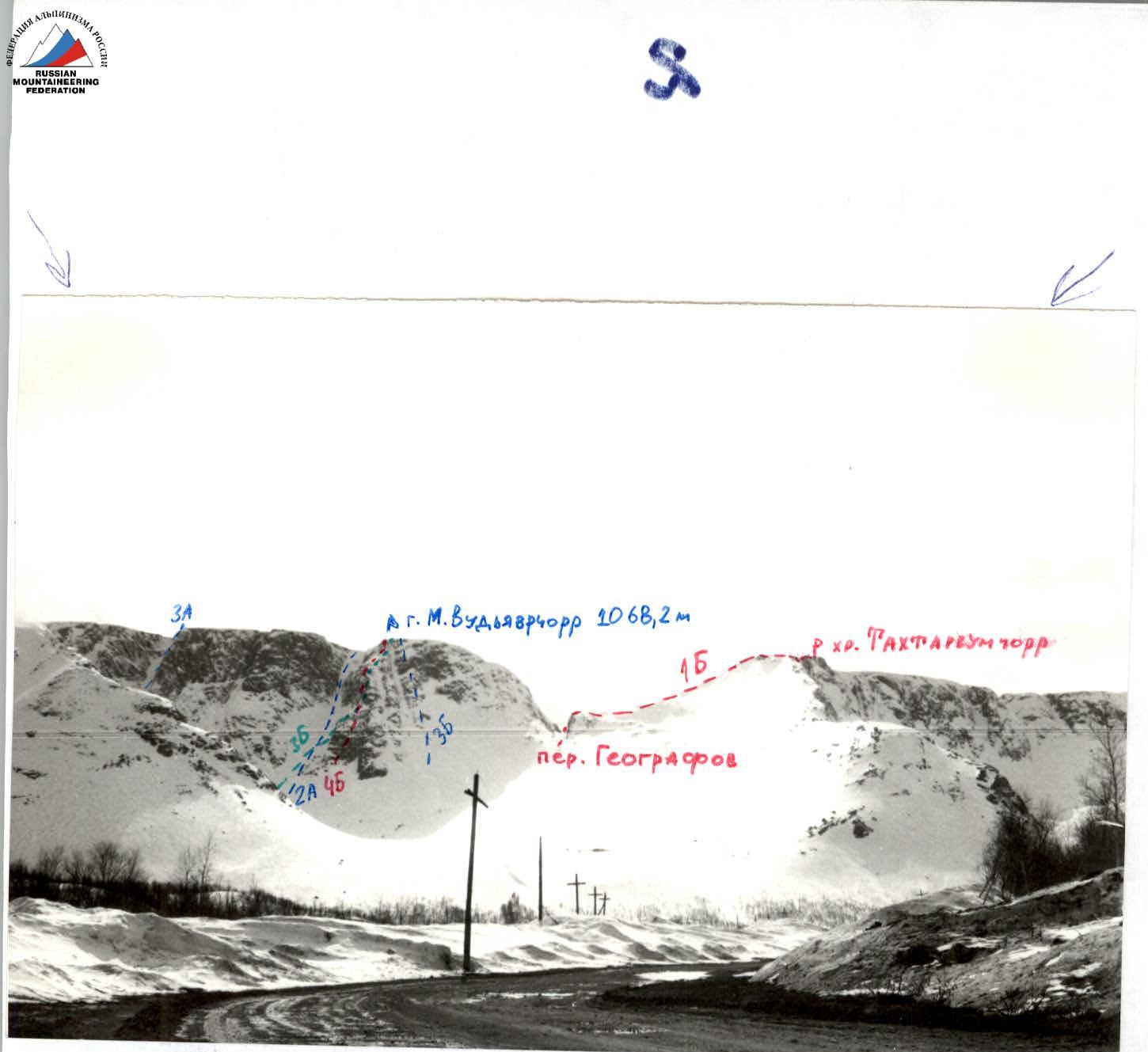
Ascent area — Khibiny Mountains.
-
Peak, its height, and route — Mt. M. Vudyavrchorr; from the "Avalanche" couloir to the I buttress of Mt. M. Vudyavrchorr; 1068.2 m.
-
Anticipated difficulty category — 3B category.
-
Route characteristics: height difference — 700 m.
Length of sections by category:
- wall II — 500 m
- III — 285 m
- 4 — 100 m
- 5 — 30 m
Average steepness: overall 55°
-
Pitons driven:
- for rock protection — 27
- chocks — 14
- ice screws — 2 In total, 4 used for creating artificial holds
-
Total climbing time — 8 hours 40 minutes.
-
Surname, name, patronymic of the leader, participants, and their qualification:
- Shumilov Oleg Ivanovich — leader, Master of Sports
- Proskura Alexander Yakovlevich — participant, 1st sports category
-
Team coach — Shumilov O.I., Master of Sports, 1st category instructor
-
Dates: March 1, 1992
 March 1, 1992. Description of the first ascent of the 3B category route, combined, polar — from the avalanche couloir to the I buttress of Maly Vudyavrchorr peak.
Team:
- Shumilov O.I. — Master of Sports — alpinism instructor-methodologist, 1st category
- Proskura A.Ya. — 1st sports category — 3rd category instructor
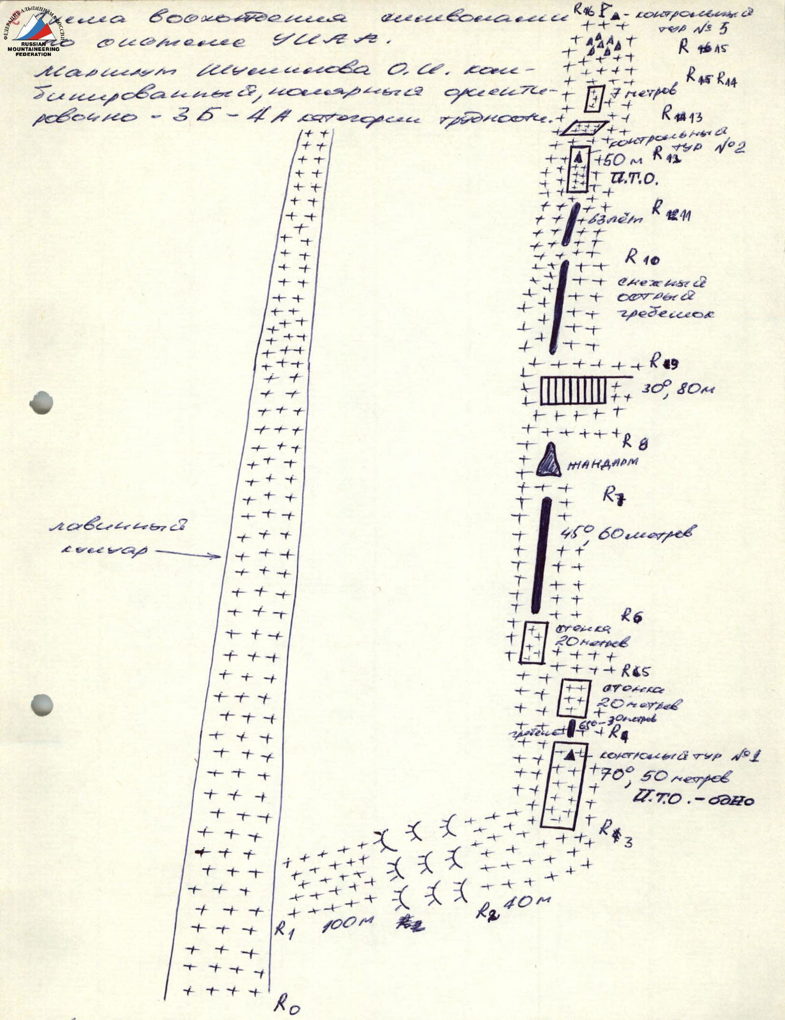
Turned off the road towards Maly Vudyavr lake at 13:15. From the lake, left into the Vudyavrchorr ridge cirque. Covered 3 rope lengths through the "Avalanche" couloir (15:45). Then 100 m right-upwards to the flattening of the I buttress ridge (route 45 to 1 M. Vudyavrchorr) — snow, ice, rocky outcrops. Average steepness 50–60°. Protection: 3 chocks, 3 pitons, 3 rock features. From the control cairn — can on a piton, traverse left 5 m, then up right 10 m and 30 m left along the ridge with 50–60° steepness. Piton and rock feature protection. Further 40 m along the gentle ridge pad to the ascent (17:20). Ascent with 70° steepness, 50 m, climbed directly (4 chocks, 8 pitons, one artificial hold). Under the overhang, control cairn — can on a piton (19:10). Then, bypass the wall to the right 20 m, then left onto the wall 20 m (piton). Further 60 m along the ridge with 45° steepness to a rocky pinnacle. The pinnacle is climbed first to the right, then 10 m vertically up, then 10 m to the right (total of 4 pitons on the section). Reached the top at 20:55. 2 rope lengths along the top with 30° steepness (slabs, flow ice, firn, Khibiny rime). Further, one rope length up along the sharp snowy ridge to the final ascent, consisting of large steps. Further 50 m of difficult climbing with challenging belay location. 8 pitons, 3 artificial holds on the section. At the end of the wall, 5th control cairn (can on a piton). Then a ledge, 7 m ascent (rocks, snow). Further, exit onto a snowy ridge leading to the plateau and then to the summit. 6th control cairn laid out from stones on the plateau (22:50). Total pitons driven — 27, chocks used — 14. Descent via the plateau to the left of the Geografov pass. Then right back through the Geografov pass and onto the trail.
27 pitons driven, 14 chocks.
R0–R1 — path through the "Avalanche couloir" — 150 m. R1–R2 — snow, rocky outcrops — 100 m. R2–R3 — snowy pad — 40 m. R3–R4 — ascent climbed directly with artificial holds — 50 m. R4–R5 — bypass of the right wall — 20 m. R5–R6 — onto the wall — 20 m. R6–R7 — 60 m with 45° steepness to a rocky pinnacle. R7–R8 — bypass to the right, then vertically up onto the pinnacle 10 m up and then 10 m to the right. R8–R9 — exit onto the roof, along it 80 m, 30°, slabs, flow ice, firn, Khibiny rime. R9–R10 — along the snowy sharp ridge — 40 m. R10–R11 — ascent — 20 m. R11–R12 — 50 m — difficult climbing, artificial holds. At the end of the wall, control cairn (can on a piton). R12–R13 — ledge — 3–5 m. R13–R14 — ascent — 7 m, rocks, snow. R14–R15 — exit onto a snowy ridge — plateau, leading to the summit. R15–R16 — control cairn laid out from stones on the plateau.
Route length — 700 m.
Pitons driven — 27.
Chocks — 14.
Approximately 3B category. Time taken from the start of the route — 7 hours.