Ascent Passport
Region — Subpolar Urals. Mountain Range — Issledovatelsky Ridge. Gorge — mountain horseshoe of the Olenevodov Plateau. Section Number according to KMGV-2001 — 8. "Other mountain systems, massifs". Name of the Peak — 1711 (p. Sverdlova). Height — 1711 m. Route Name — along the oblique fault of the northeastern wall. Difficulty Category — 3A cat. dif. Route Character: Combined. Elevation Gain — 1100 m. Route Length — 2700 m. Sections of 5th cat. dif. — none. Sections of 6th cat. dif. — none. Average Steepness of the main (technical part) of the route — 65°. Average Steepness of the entire route — 55°. Pitons on the route — none left behind. Pitons Used — none.
Team's Travel Time:
- From the "Manaraga" shelter to the "Polyakovskie nochyovki" bivouac — 18 hours.
- Ascent from the "Polyakovskie nochyovki" bivouac — 6 hours.
Leader: Prima S. N., 2nd sports category. Participants: Gorobets N. N., Tulaev V. A., Leushev S. V. Coach: Polyakov Sergey Nikolaevich, 1st sports category, instructor 2nd cat.
Entry onto the route — 8:00, July 11, 2005. Reaching the summit — 11:00, July 11, 2005. Return to the base camp — 16:00, July 11, 2005.
Expedition: Youth Scientific and Sports Expedition of the Alpinism Federation of RK "Pobeda-2005", July 17 — August 2, 2005.
Executed by Zhuravlev S. V., Prima S. N.
Syktyvkar 167000, Internatsionalnaya str., 97, apt. 12. Phone 24-24-91. E-mail: Zhur58@rambler.ru
Inventory List
 CONTROL COUPON №
(valuables) issued to the owner)
Controller. Date of issue.
CONTROL COUPON №
(valuables) issued to the owner)
Controller. Date of issue.
 View from the upper cirque of the mountain horseshoe of the Olenevodov Plateau
Ascent Scheme in the IAA Signs System
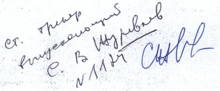
p. Sverdlova (?) (1711) p. Regule (1650) (?) ROCK TOWER NORTHERN WALL Central oblique fault N-E
- R0 — bivouac "Polyakovskie nochyovki" under the northeastern wall of p. Komsomola (1729).
- R0–R1 — ascent to the base of the northeastern wall along the talus slope under the northeastern wall. Slope 20–30°. Talus. 500 m. Non-categorized.
- R1–R2 — ascent along the talus couloir to the snowfield under the northeastern wall of p. Sverdlova. Slope 40–45°, 1.
- R2–R3 — entering the fault. Oblique traverse of the northeastern wall to the left, towards the southwestern ridge along a snow-ice slope 45–50°. Pressing against the wall. "Rockfall danger!" Alternating belay. Organization of belay stations on the rocks of the northeastern wall or (if the ice is exposed) using ice screws. 500 m of oblique traverse, 3. To the middle part of the "funnel" fault.
- R3–R4 — ascent along the central part of the oblique fault. Ice steeper than 65°. Rocks 3–3+. "Loose. Severely weathered rocks. Subjective and objective rockfall danger!" About 200 m. Alternating belay. Organization of belay stations on the rocks of the northeastern wall or (if the ice is exposed) using ice screws.
- R5–R6 — upper couloir of the oblique fault. Exit onto the saddle between p. Sverdlova (?) and p. Regule. 150 m. Rocks 3. 50–65°. "Loose. Severely weathered rocks".
- R6–R7 — movement along the severely weathered ridge (simultaneous or alternating belay on outcrops) and exit under the summit tower. Section length 300 m. Rocks 2–2+.
- R7–R8 — movement along rock ledges and cracks to the summit tower. 200 m. Rocks 2–2+.
- R8–R9 — ascent to the summit. "Key to the 2B route along the southeastern slope and southeastern ridge from the Manhobe glacier". Rock chimney 10 m. Steepness up to 85°. Rocks 3.
- R9 — summit of peak Sverdlova (?).
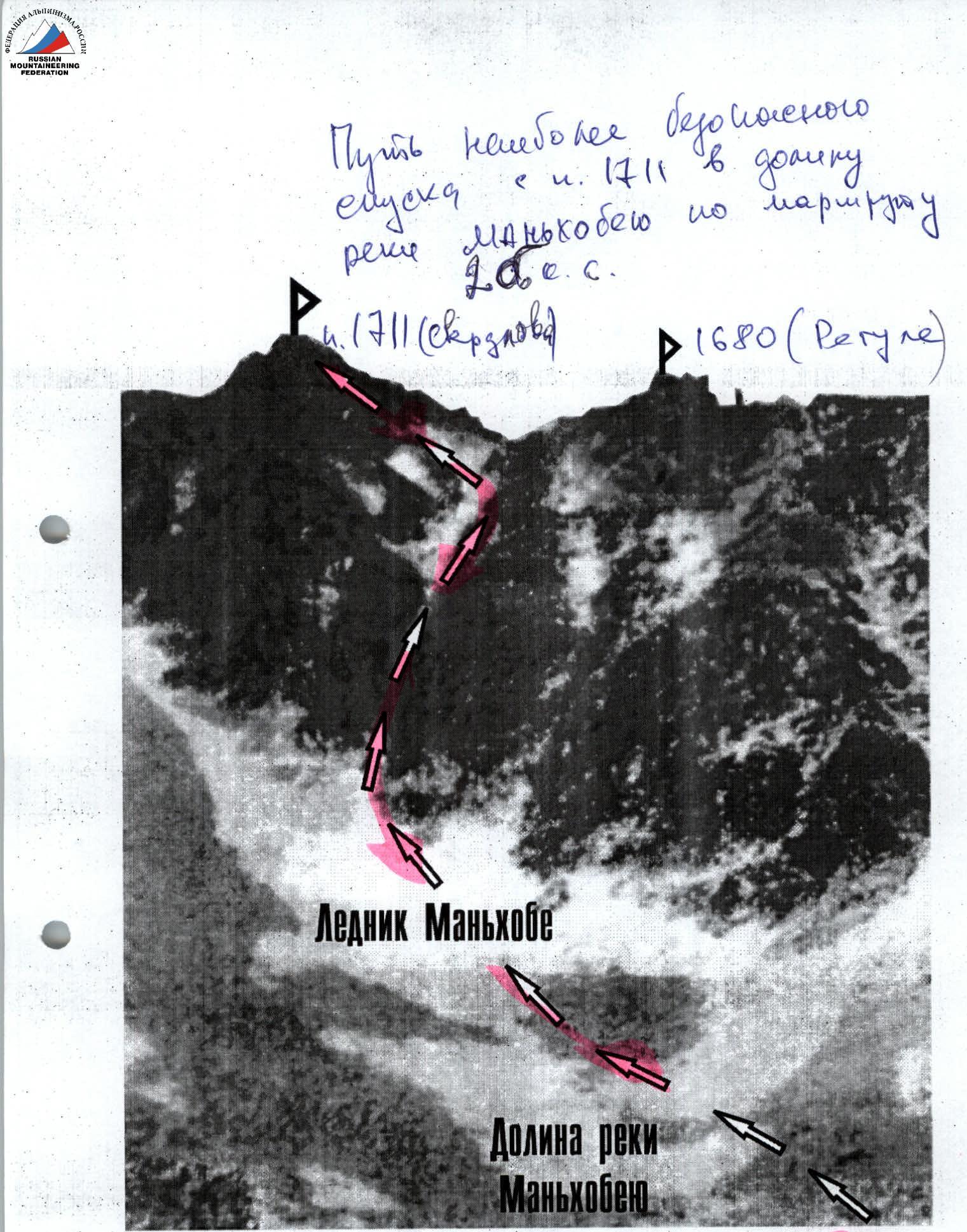
- R9–R0 — descent from the summit along the 2B route into the Manhobe river valley.
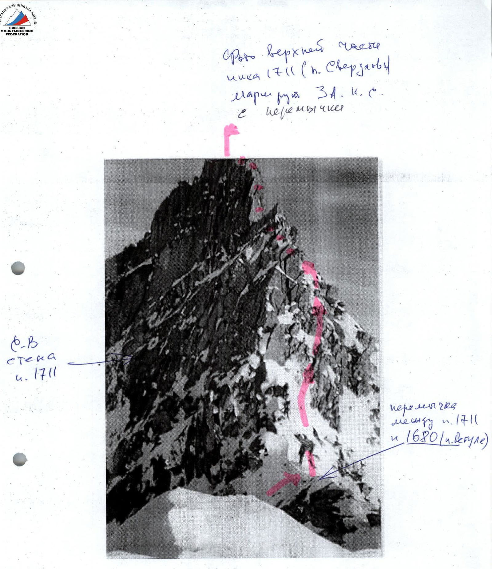
Photo of the upper part of peak 1711 (p. Sverdlova), 3A cat. dif. route to the saddle.
 Northeastern wall, 1711.
Saddle between p. 1711 and p. 1680 (p. Regule).
Visible part of the route. Invisible part.
Northeastern wall, 1711.
Saddle between p. 1711 and p. 1680 (p. Regule).
Visible part of the route. Invisible part.
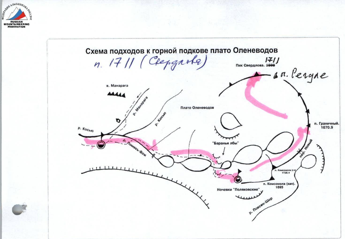
Scheme of approaches to the mountain horseshoe of the Olenevodov Plateau p. 1711 (Sverdlova)
Mountain horseshoe of the Olenevodov Plateau (view from "Polyakovskie nochyovki")
- v. Bezymyannaya-1 (1675).
- v. Bezymyannaya-2 (1680).
- p. Sverdlova (?) (1711).
- p. Regule (1650).
- v. Bezymyannaya-3 (1600).
- v. Bezymyannaya-4 (1661).
- p. Granichny (1671). In the photo, hidden by the eastern slope of p. Komsomola (?).
- p. Komsomola Main peak (1729).
- p. Komsomola Western peak (1695).
Description of the Peak (OSP)
Height 1711 m. Located in the Issledovatelsky Ridge, in the mountain horseshoe of the Olenevodov Plateau. The slopes of this mountain horseshoe are the sources of the Manhobe river, the Khobe river, the Lomesvож stream, and their tributaries. Directly below the peak to the southeast is the Manhobe glacier. Peak Sverdlova (?) is considered the most inaccessible peak in the Subpolar Urals.
Description of the Route (OSP)
Approach: from the base camp on the Kosyu river bank, move along the Lomesvож stream to the Olenevodov Plateau, then across the plateau to the "Polyakovskie nochyovki" near a nameless lake under the Northern wall of peak Komsomola (?).
An alternative approach is possible (see approach scheme) both from the left along the route, across the Olenevodov Plateau, and from the right, after crossing the stream under the cliffs bounding the plateau, along talus slopes. During the approach, in the upper part, there are rock sections, large-block talus, and sheep's backs 1–2. The approach from the base camp on the Kosyu river takes 8–12 hours. "Polyakovskie nochyovki" is a convenient place for setting up a bivouac. A convenient location for observing the ascent area. Peak Komsomola (?) is the first peak on the right among the peaks of the mountain horseshoe, characteristically expressed by a double peak with a large gendarme between them. Peak Sverdlova (?) is the dominant peak in the left part of the mountain horseshoe of the Olenevodov Plateau. From the northeast, it looks like a wall with a wide oblique fault from bottom to top and from left to right. This wide fault, ending in a rock-ice couloir leading to the southwestern ridge onto the saddle between p. Sverdlova (?) and p. Regule (?), is the path along which the 3A route lies.
Technical part: from "Polyakovskie nochyovki", transition to the upper lake of the mountain horseshoe of the Olenevodov Plateau along talus slopes. (No trails). It is necessary to approach the snowfields at the base of the northern wall of p. Sverdlova. "Rockfall danger! Loose rocks. Regularly falls from the left, most weathered part of the northern wall". Then, an oblique traverse of the slope to the snow slope, followed by movement upwards along the fault, pressing against the wall, to the middle part of the "funnel". Then — upwards to the left along the central fault along a series of rock ledges of the northeastern wall or along the ice lying in the center of the fault. "In summer — exposed ice, ice equipment required!" Organization of belay stations — rock pitons, chocks, driven, inserted into cracks and faults of the northern wall, as the entire section is a prolonged oblique traverse along the fault at the junction of ice and rocks with a constant gain in height. In the upper part of the fault, on exposed ice, belay on ice screws. The couloir narrows and leads onto the southwestern ridge, onto the saddle between p. Sverdlova (?) and p. Regule. "p. Regule — a large, weathered gendarme on the southwestern ridge of p. Sverdlova (?)".
The exit onto the saddle from the oblique fault along the rock-ice couloir is the most challenging part of the route. "Key!" Requiring operational thinking from the participants and the ascent leader, as changes in the relief of this section are unstable and difficult to predict during the entire alpine event. Over the course of several days or a week, this section of the route can have pure ice, with a steepness of more than 65°, similar in structure to the winter ice of the Caucasus; it can be the same ice covered with a 30–40-centimeter layer of loose, weakly bonded, coarse-grained snow, requiring participants to transition to severely weathered rocks of medium level 3–3+; rocks can be clean one day and covered with a multi-centimeter layer of hoarfrost the next. That is, there are about 200 m of mountain relief objectively requiring experience in passing combined routes, with constant changes in equipment.
Then, movement along the southwestern ridge. Along the severely weathered ridge (simultaneous or alternating belay on outcrops), exit under the summit tower. Then, movement along rock ledges and cracks to the summit tower. Ascent to the summit along a chimney — 10 m. "Key to the 2B route along the southeastern slope and southeastern ridge from the Manhobe glacier".
Turnaround point: in case of worsening weather or the group's inability to continue the ascent, the turnaround point is the beginning of the couloir in the upper part of the oblique fault.
Recommended descent: along 2B into the Manhobe river valley.
Total passage time: the passage of the route from the base camp in the Kosyu river valley with a return to the base camp requires at least 3 days. Passage of the technical section from the "Polyakovskie nochyovki" area — 10–14 hours.
Required equipment for a sports group of 4 people:
- Climbing rope — 2×50 m.
- Ice screws — 5 pcs.
- Chocking devices — 10 pcs. (standard set of stoppers) plus large hexes and off-belays.
- Rock pitons — 10 pcs.
- Belay loops — 5–8 pcs.
- Ice axe (ice hammer or axe) — 2 pcs.
- Ice axes — 4 pcs.
- Primus (gas burner) — 1 pc.
- Poncho capes — 4 pcs.
- Tent — 1 pc.
The safest descent path from p. 1711 into the Manhobe river valley along the 2B route