- Section number according to KMGV — 2010 — 8.3.66
Polar Urals, Raiiz mountain range, Nyrd-Vomen-Shor river valley
- Name of the peak: 1256.4
height: 1256.4 m, route: via eastern ridge through Monakh
- Category of complexity: 1B, pp
- Nature of the route — combined.
- Height difference of the route: 433 m (according to the 1964 General Staff map)
Route length: 1700 m. Length of sections with the highest category of complexity:
- 2+ — 200 m
- 3= — 100 m. Average steepness:
- main part of the route — 65°
- entire route — 45°
- Total equipment used on the route: rock pitons — 3, chocks — 12.
Pitons used: stationary bolt pitons — 0, ITO — 0, removable bolt pitons — 0.
Pitons left on the route: total — 2; including bolt pitons — 0.
- Departure for the route — 7:00, August 7, 2010
Reached the summit — 12:30, August 7, 2010
Returned to the base camp — 16:00, August 7, 2010
- Team's total climbing hours: 9 hours.
- Leader: Maltsev Sergey Leonidovich, 1st sports category, 2nd category instructor-methodologist
Team members:
- A. Bobretsova (3rd sports category, Syktyvkar)
- M. Blok (3rd sports category, Salekhard)
- I. Shcheglov (3rd sports category, Moscow)
- D. Sivkov (3rd sports category, Syktyvkar)
- Coach: Zhuravlev Sergey Vasilievich, CMS rank, 1st category instructor-methodologist.
Description of peak 1256.4
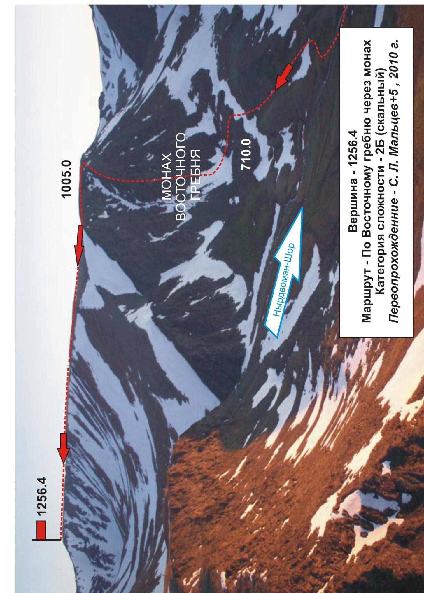
Peak 1256.4 is located in the southern part of the Polar Urals, in a glacial cirque where the Nyrdvomen-Shor river catchment area forms, a right-bank tributary of the Sob' river. The peak is part of the Raiiz mountain range and stands on the watershed between the Enga-yu and Sob' river basins.
Peak 1256.4 can be an object for training and sports ascents, as it has several pronounced rock ridges and snow-ice slopes. These include:
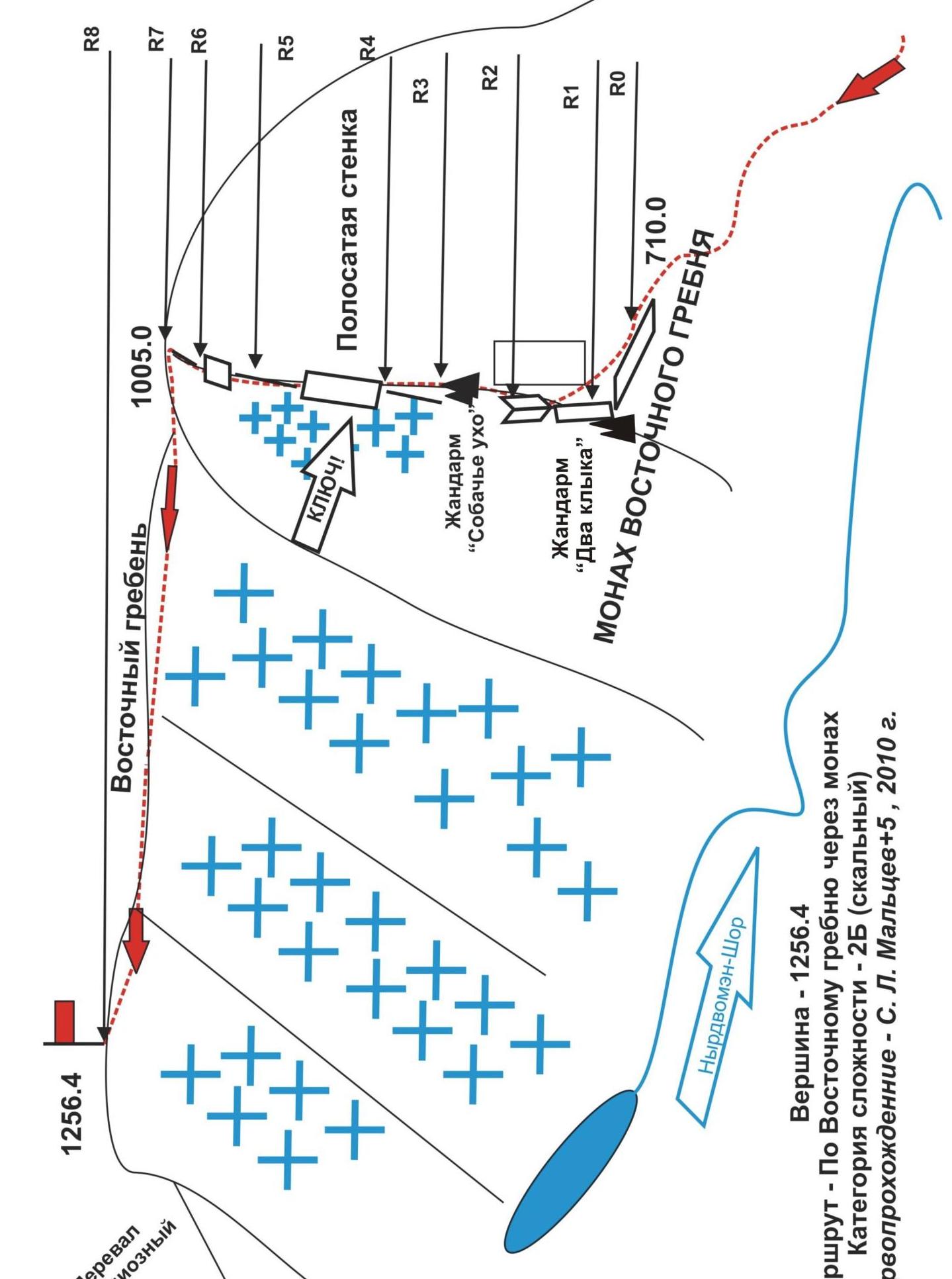
- the eastern ridge, culminating in a rock monolith called Monakh;
- the southern ridge, descending to the Grandiose pass.
Description of the route via the eastern ridge through the rock Monakh
The route to peak 1256.4 via the eastern ridge through the rock Monakh should be classified as a 2B training and sports route, as it has all the characteristics (total set of natural obstacles) required for corresponding training and sports routes.
- Rockfall danger — subjective: there are loose rocks on the ledges, but overall the route follows rock monoliths.
- Orientation landmarks are clearly visible.
- The key section of the route is clearly defined and has a higher level of complexity compared to other sections.
Equipment
To complete the ascent as part of a training and sports group of 6 people (5 participants + instructor), the following special equipment is required on the route:
personal — standard,
communal:
- main rope 10 mm — 3×50 m
- rock hammer — 1 piece
- ice axe — 1 piece
- rock pitons — 8 pieces
- chock elements — 2 sets
- stoppers — 2×6 pieces (plastic stoppers made in Kharkov were used)
- quickdraws — 12 pieces
- slings — 12 pieces
Approach
From the base camp in the Nyrdvomen-Shor river valley, follow the all-terrain vehicle road along the Nyrdvomen-Shor river:
- ascend to the abandoned geological cabins (1.5 hours);
- then proceed to the base of the rock Monakh (0.5 hours).
Technical part
The route is easily identifiable by its characteristic features: the rock Monakh and the rock ridges leading to the eastern ridge. The starting point of the route is determined by the distinctive landmark "Two Fangs" (see photo #1). Then, move right along the ledges to bypass a smoothed inclined wall and exit onto a ridge. The route then follows the ridge to the summit of Monakh. Insurance points throughout the route are convenient and allow the group to gather.
The main difficulty lies in traversing the rock ridge of Monakh — 6 pitches of varying complexity, with two sections of 3rd category complexity:
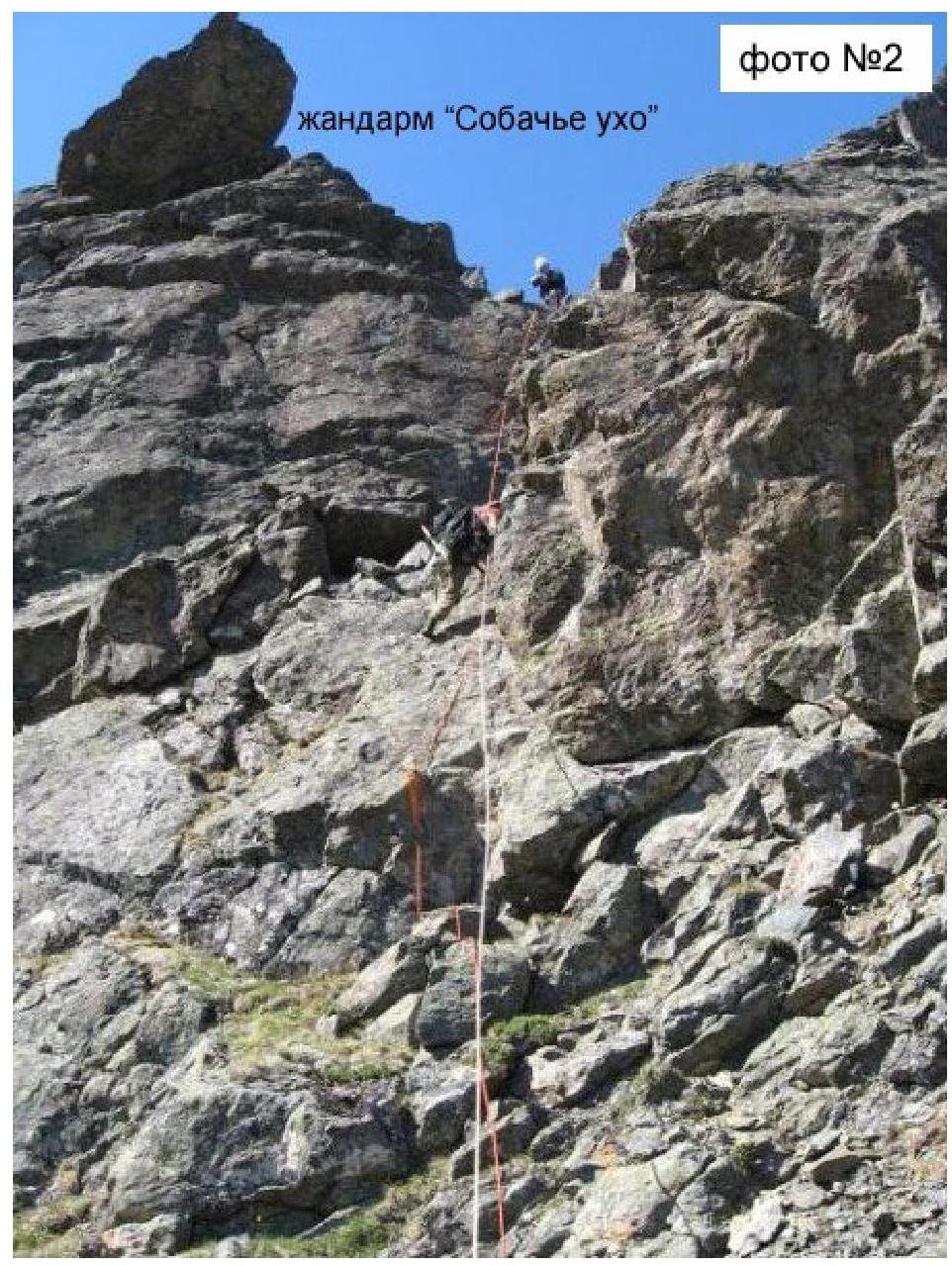
- 1st section — an internal corner, 20 m, 65° steepness, under the landmark "Dog's Ear" (see photo #2), where piton protection is required — small cracks in smoothed rocks.
- 2nd section — the key part of the route, 3rd category complexity, 50 m long with an average steepness of 75° — "Striped Wall" (see photo #4).
After reaching the rock Monakh, the route does not present significant technical difficulties — a non-technical snow (or scree in late summer) gentle ridge leads to the summit. The summit is easily identified by a triangulation marker. There were no notes found on the summit.
Descent from the summit
First, follow the eastern ridge, then descend along a snowy slope to the left into a wide and safe couloir separating peak 1256.4 from peak 1159 (Dinozavr Glavny). Continue down the snow to the all-terrain vehicle road.
Peak — 1256.4 m. Route — via eastern ridge through Monakh. Category of complexity — 2B (rock). First ascent — S. L. Maltsev + 5 others, 2010.
Peak — 1259.4 m. Route — via eastern ridge through Monakh. Eastern ridge. Category of complexity — 2B (rock). Time to summit — 1.5 hours.
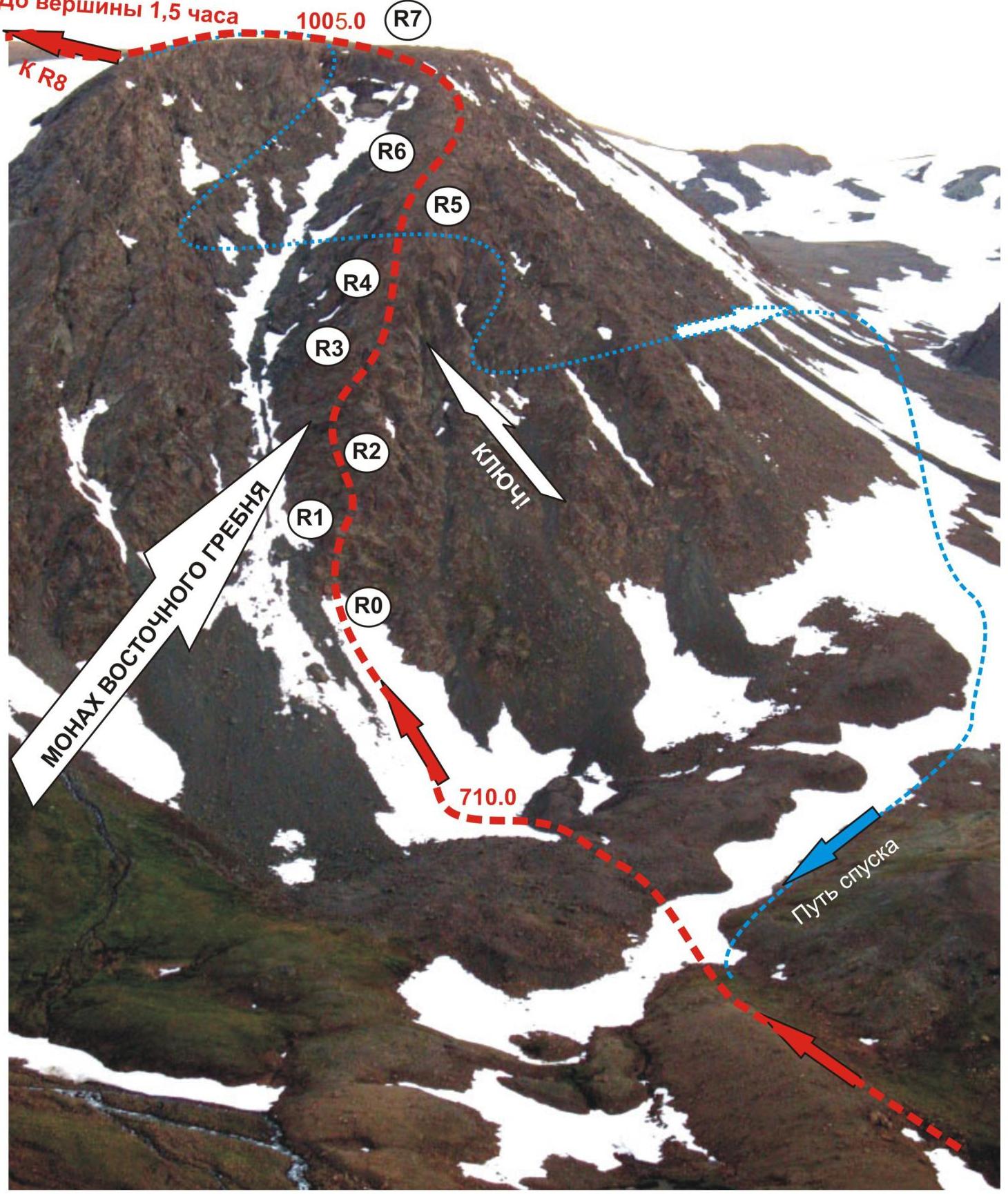
Photo of the technical part of the route taken from the western ridge of Raiiz peak.
1256.4
Brief description of the route in UIAA symbols
R0 — start of the route (elevation mark 710.0 m). Location for organizing rope teams — a scree ledge at the base of the landmark "Two Fangs".
R0–R1 — bypassing a smoothed wall to the left along a series of ledges and small 3–5 m walls. Rock. Length 80 m. Steepness 45–50°, rock complexity 2B category. Movement with alternating protection.
R1–R2 — traversing an internal corner under the landmark "Dog's Ear". Rock: length 20 m, steepness 65–70°, complexity level — 3B category. 3 rock pitons and 3 stopper chocks were used for intermediate protection points. Movement with alternating protection.
R2–R3 — movement along the ridge. Rock, series of ledges and small 3–5 m walls. Length 100 m. Steepness 45–50°, rock complexity 2+ category. Movement with alternating protection.
R3–R4 — traversing the key section "Striped Wall". Rock — 60 m, wall steepness 70°, in the upper part 80°. Complexity level — 3-, in the upper 10 m — 3+ category. Used for intermediate protection points:
- 8 chock elements
- 4 slings on outcrops. Rope team interaction — rope protection.
R4–R5 — movement along the ridge. Rock, series of ledges and small 3–5 m walls. Length 50 m. Steepness 45–50°, rock complexity 2+ category. Movement with alternating protection.
R5–R6 — traverse along a slab and bypassing an overhanging section along an internal corner in the right part of the ridge. Rock, series of ledges and small 3–5 m walls. Length 50 m. Steepness 45–50°, complexity — 2+ category. Movement with alternating protection.
R6–R7 — exit onto the summit of Monakh and the eastern ridge (elevation mark 1005.0 m). Rock, series of ledges and small 3–5 m walls. Length — 50 m. Steepness — from −50° to −30°, complexity — 2 category. Movement with alternating protection.
R7–R8 — exit onto the summit along the ridge. Length of the section — 1500 m. Non-technical, snowy (scree) ridge. Simultaneous movement.
R8 — summit 1256.4. Plateau-like, with a triangulation marker at the highest point.
Descent from the summit:
- first along the eastern ridge,
- then down the western snowy slope into a dividing couloir,
- down the couloir,
- then along the all-terrain vehicle road to the base camp.
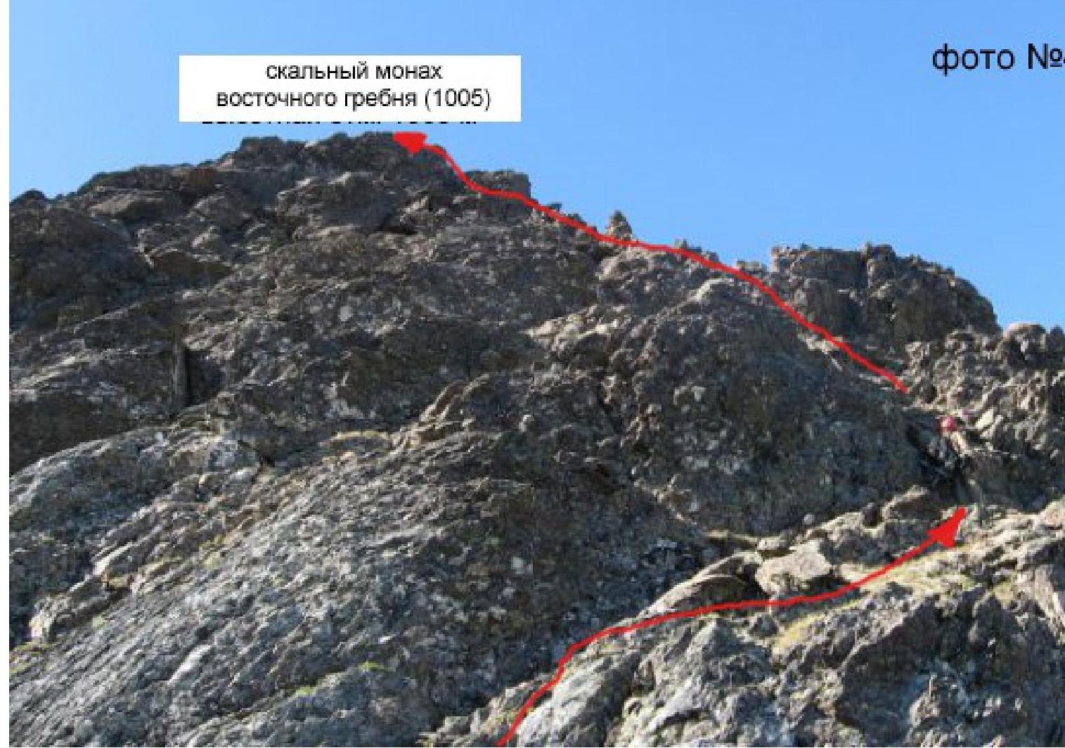
photo #1
Photo #1
landmark "Two Fangs" — a characteristic orientation point at the start of the route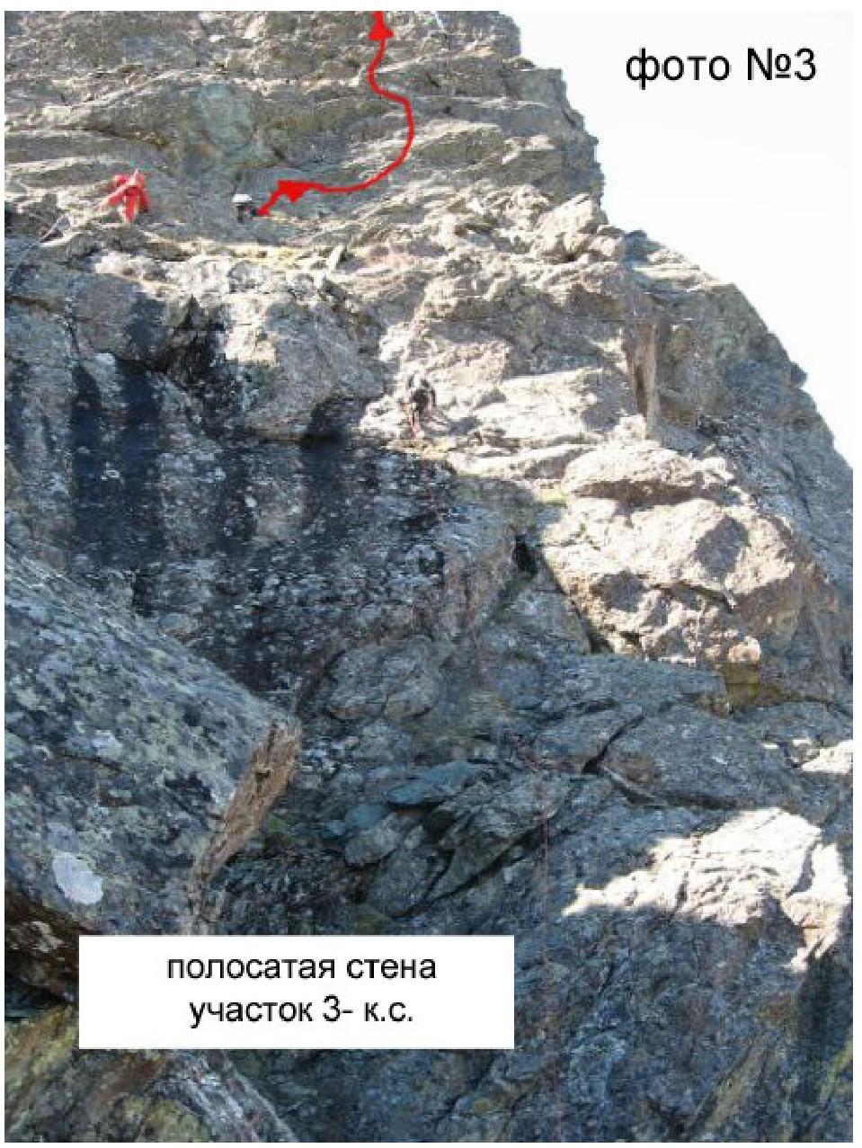
photo #3