Peak 1287 (Topografov Peak) Route: via western wall Approximate complexity category: 4A Leader: Goletarov A. Polar Urals, Raiiz mountain range
Report
On the first ascent of the climbing route to Peak 1287 (Topografov Peak) via the route: "Via western wall" approximately 4A category of complexity (Rocky) at the year-round alpine event "Cup of NP 'Club of Northern Travels 'Sauk-Pai'" 2015 (Fourth stage. Class "First ascents").
Region: Ural Federal District of the Russian Federation (UFD), Yamalo-Nenets Autonomous Okrug of Tyumen Oblast. Mountain country: Polar Urals. Gorge: Valley of the Sob River. Ridge: Raiiz mountain range, northwestern cirque. Peak: 1287 (Topografov Peak). Route: via western wall. Category of complexity: approximately 4A category of complexity. Character of the route: rocky. Prepared by: A. Goletarov, S. Nikolaeva, Zhuravlev S. V. July 2015 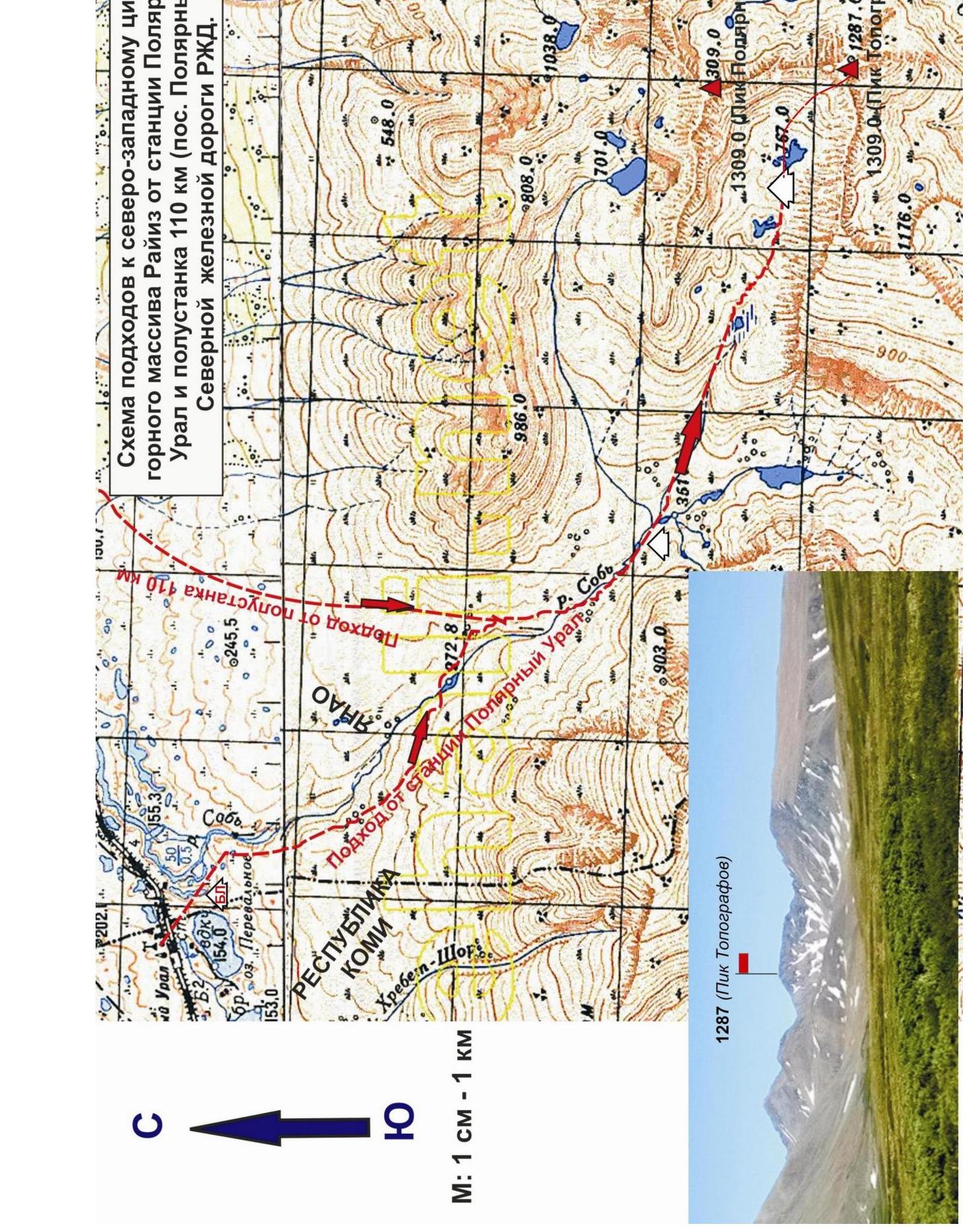
Scheme of approaches to the northwestern cirque of the Raiiz mountain range from the Polar Ural station and the 110 km halt (Polarny settlement) of the Northern Railway.

Polar Urals. Raiiz mountain range. Northwestern cirque. Peak — 1287 (Topografov Peak). Route: "Via western wall". Level of complexity: approximately 4A category of complexity (Rocky). Technical photo of the route. Photo from the northwestern cirque, July 2015.
Passport
- Section number according to KMGV — 2010 — 8.3.
Polar Urals, Raiiz mountain range (northwestern cirque), valley of the Sob River.
- Name of the peak: 1287 (Topografov Peak)
height: 1287 m
- Route: via western wall.
- Category of complexity: proposed 4A category of complexity.
- Character of the route — rocky.
- Height difference of the route: 650 m
- Length of the route: 440 m
- Length and level of complexity of technical sections:
| 1 cat. cl — | 2 sections — 160 m, | |
|---|---|---|
| 2 cat. cl — | 5 sections — | 107 m, |
| 3 cat. cl — | 0 section — 0 m, | |
| 4 cat. cl — | 5 sections — | 185 m, |
| 5 cat. cl — | 2 sections — 55 m, | |
| 6 cat. cl — | 0 sections — | 0 m. |
- Average steepness: main part of the route — 65 degrees. Key section — 85 degrees. □
- Number of pitons used:
Total number used on the route:
- rock pitons — 17 pcs
- chocks — 35 pcs.
- stationary bolt pitons — 0
- IT — 0
- removable bolt pitons — 0
Left on the route: total — 4; including bolt pitons — 0.
- Exit to the route — 6:00, July 6, 2015.
Reached the summit — 18:00, July 6, 2015. Returned to the base camp — 21:30, July 6, 2015.
- Team's walking hours: — 17 hours.
- Leader: A. Goletarov (Inta, 2nd sports category).
Participants:
- V. Disnenko (Inta, 2nd sports category)
- S. Nikolaeva (Voronezh, 2nd sports category)
- Coach: Zhuravlev Sergey Vasilyevich (Syktyvkar, Candidate Master of Sports, instructor-methodologist of the 1st category).
Description of the peak
Peak 1287 (Topografov Peak) is one of the most interesting peaks for climbers in the Raiiz mountain range, located in the Yamalo-Nenets National Okrug (YaNAO) of Tyumen Oblast, Ural Federal District of the Russian Federation, on the eastern slopes of the Polar Urals, on the watershed of the mountain valleys of the rivers:
- Sob (west)
- Enga-Yu (southeast)
The peak is a pronounced rocky truncated pyramid with a flat summit, dissected by southeastern, southern, and northern ridges, and steep rocky walls descending to the west and northwest. The height of 1287.0 m is marked on the maps of the General Staff of the Russian Federation. The name is unofficial but has taken root in the tourist and climbing community: likely given after the name of the glacier located on the southeastern slopes of the mountain. Serves for identification of the peak.
Routes have been laid and classified to Peak 1287 (Topografov Peak):
- route from the northwest along the ridge
- route from the east along the ridge
- route from the southeast along the ridge
- route from the south along the ridge
- route from the southwest along the ridge
- route from the west along the ridge
- route from the northwest along the ridge
- route from the north along the ridge
- Along the NW ridge — 1B category of complexity (winter);
- Traverse 1309 (Polarny Peak) — 1287 (Topografov Peak) 2B category of complexity from NW to NE (winter).
Climbing development of the mountain continues. The proposed route for classification was climbed during the face-to-face climbing competitions in the "Class 'First ascents'" discipline as part of the Cup of NP "Club of Northern Travels 'Sauk-Pai'" (Syktyvkar) in July 2015.
Description of the route: "via western wall" (rocky) 4A category of complexity.
Route: "Via the second buttress of the western wall (rocky)" — a technically complex rocky route for sports groups of climbers with comprehensive knowledge, skills, and experience in movement, organization of belays, and self-belaying on complex rocky terrain.
Technical part of the route:
- Uniform in complexity
- Saturated with obstacles
- Logical in organization
- Follows a pronounced buttress
Subjectively rockfall-prone.
Equipment
For the ascent, a sports group needs the following special equipment:
Personal — standard; crampons and ice axe are mandatory only in winter or during the off-season;
Public:
- main rope 10 mm — 2 pcs × 50 m
- chock elements — 12 pcs.
- anchor pitons — 6 pcs.
- friends — 4 pcs.
- quickdraws — 12 pcs.
- slings — 6 pcs.
- rock hammer — 2 pcs.
Approach
From the Polar Ural railway station of the Northern Railway, go up the Sob River valley (about three hours) to the confluence of two large streams on the right and left banks almost opposite each other.
Crossing either of the tributaries along the way, you can find suitable platforms on both the right and left banks of the Sob River. In the area of these tributaries, there is:
- a convenient ford across the Sob River itself.
Or continue moving and ascend along the next right (orographic) tributary into the cirque of Polarny Peak and Topografov Peak. The closed cirque is formed by the slopes of Polarny Peak and Topografov Peak; between the peaks is a pass — Yuzhny Karovyy. In the cirque, among numerous moraines and lakes, you can find small platforms for tents.
Features of the area:
- Until June, there may be snow on the upper platforms, and ice on the lakes.
- Cooking in both variants is only on gas or gasoline burners.
- Water suitable for drinking is available everywhere, flowing (including in lakes) — without boiling.
- The area is characterized by periodic strong winds, which must be considered when choosing and setting up a tent.
From the lakes, the route is clearly visible — the second buttress of the western wall of Topografov Peak. The lower part may be closed by moraines; when approaching closer to the wall, it opens fully.
Technical part
From the lakes, through a series of moraines, approach the talus slope and further along the talus and gentle snowfields, reach the base of the second buttress. Organize a link under the buttress.
The route begins with an ascent onto the rocky ridge of the buttress. Through a simple inner corner and несложные скалы выходим на осыпной гребень, затем по наклонным плитам — к началу технической части маршрута.
Movement in this section is simultaneous, with the rope laid along the relief folds. When passing the upper part of the slabs, it is possible to use the relief of the adjacent wall for chock placement.
The upper part of the slabs leads into a "pocket" turning into a wall. Here it is necessary to organize a station — a convenient platform for re-equipping (if necessary) and arranging equipment.
Further movement is in a link, alternating, along the wall with a steepness of up to 70°. Level of complexity — 4 category of complexity.
Features of the section:
- Abundance of large relief, convenient for climbing and organizing belay points.
- Belay through slings, camalots, and chocks, predominantly large sizes.
- Base station — a sling on a rocky outcrop.
Further along the wall through an inner corner with a steepness of up to 70°.
Features of the section:
- Abundance of large relief.
- Very convenient for movement in opposition.
- Belay also through slings, camalots, and chocks, predominantly large sizes.
- Base station — a sling on a rocky outcrop.
Further along the slabs to a short chimney with an overhang — the first key of the route.
First key: represents a series of slabs and stone blocks turning into a short chimney with an overhang. The approach to the chimney is not complicated; climbing is not higher than 4 category of complexity. For belaying, it is convenient to use gaps between blocks.
The first intercepts in the chimney can be made:
- in an offset
- or in opposition
Belaying elements are placed in the gap between the overhanging block and the adjacent walls. The overhanging block is bypassed on the right. There are convenient holds behind the block, and feet stand well on friction. The exit is by pulling up onto the adjacent block. With climbing skills, passing the key should not cause difficulty.
Further — through a simple wall of 2 category of complexity to the talus ridge.
Base station — a sling (main rope) through a large stone block with blocking by chocks, not reaching the talus ridge.
Having passed the talus ridge, we exit under an inner corner with an exit onto the wall. The inner corner is conveniently passed in opposition; for belaying, chock elements of medium to small sizes and camalots are used. Average steepness of the section — 70°, climbing up to 4 category of complexity.
Base station — on blocked chock elements with a convenient platform.
Further — an inclined wall up to 60°. Climbing not higher than 4 category of complexity. For belaying, small gaps are used with the use of predominantly small sizes of chock elements and anchor pitons.
Base station — on blocked chock elements.
We exit under the second key of the route.
Second key of the route: represents a wall with a kink with a steepness of up to 85°. The wall before and after the kink is not higher than 4 category of complexity. The kink itself consists of larger monolithic blocks and is more complex for climbing — 5 category of complexity.
The section requires the ability to organize belay points using:
- slings,
- anchor pitons,
- camalots,
- chocks, predominantly small sizes.
Base station — a sling with the main rope through a protruding part of the slab with blocking by chocks.
Further, through a simple section with a steepness of not more than 40°, we approach monolithic smooth rocks. The rocks have passive holds; climbing is on friction; for belaying, it is possible to use anchor pitons. The section was bypassed by the first ascenders due to bad weather. The bypass is to the right along an inclined ledge of 2 category of complexity. Under the inner corner. Station at the end of the inclined ledge on blocked anchor pitons.
Further — through an inner corner onto the wall:
- Steepness of the section up to 65°
- Complexity not higher than 4 category of complexity
- For belaying, camalots and chock elements of all sizes were used
Base station on a small ledge at the end of the rocky wall on the transition to the talus ridge (lacked several meters of 60 m rope). Assembled from:
- Two blocked chocks
- A sling on a stone block
The route exits onto the ridge under the summit. Further along the simple ridge to the summit — just over a hundred meters.
Summit
The summit is a plateau. On the plateau, there are several cairns; the nearest one is in the northern part of the plateau, immediately at the exit of the ridge.
Descent from the summit
Along the ridge towards the Yuzhny Karovyy pass. It is better to start the descent before reaching the pass saddle. Complexity of the descent is 1B category of complexity.
P.S. The route consists of two pronounced rocky bastions separated by a talus area. The route has many sections of "passable" fourth-category climbing with short elements (1–3 m) of 5th category of complexity. The route requires the ability to use chock elements of various sizes. The first ascenders' group lacked small-sized camalots; their presence would have accelerated the creation of belay points.
Polar Urals. Raiiz mountain range. Northwestern cirque.
Peak: 1287 (Topografov Peak). Route: "Via western wall". Level of complexity: approximately 4A category of complexity. Character of the route: rocky.
Table of natural obstacles on the route:
| Section | Length | Steepness | Character of relief | Cat. cl. | Number of Pitons/Chocks | Photo number |
|---|---|---|---|---|---|---|
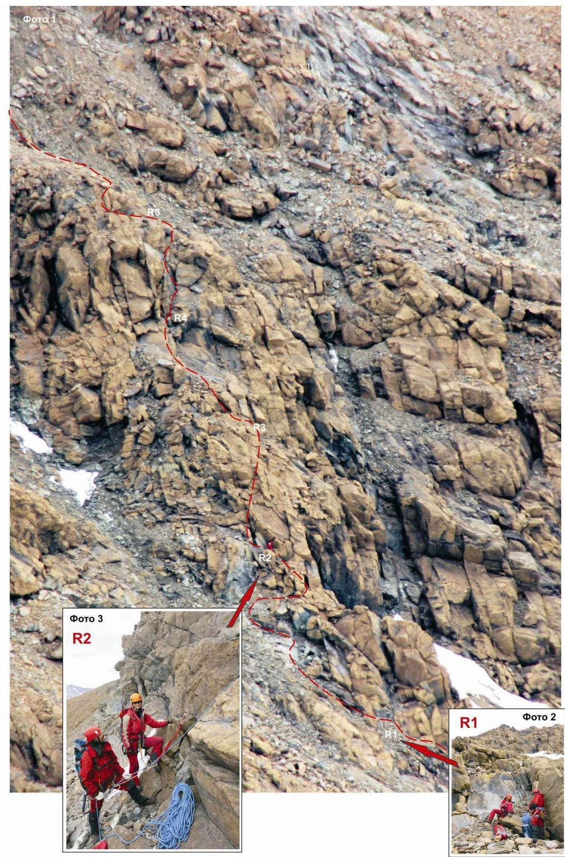
| APPROACH | From bivouac "Upper Gissarskie overnight stay" to the place of organization of links (rocky island under the left buttress of the western wall) — 1.5 hours. | №1, №2 | ||||
| R0–R1 Ascent under the western wall. First inner corner. | 5 | 35 | Not steep smooth rocks. | 2- | Used 0/0 Left 0/0 | №3 |
| R1–R2 Ascent onto the rocky ridge of the buttress. | 40 | 45 | Ledges, inner corner. | 2- | Used — 0/0 Left — 0/0 | №4, №5 |
| R2–R3 Approach to the start of the technical part. | 120 | 20 | Talus slope. | н/к | Used — 0/0 Left — 0/0 | №6 |
| R3–R4 Passing the inclined slab. Exit to the ledge under the "Lower bastion" | 12 | 45 | Inclined slab. From above — a flat ledge. Convenient place for re-equipping in rock shoes. | 2+ | Used — 0/2 Left — 0/0 | |
| R4–R5. | 45 | 70 | Rocky wall. | 4- | Used — 2/7 | |
| Passing the wall. Exit under the small key. | Steep, dense, but with an abundance of microrelief for organizing intermediate points. (Subjective rockfall danger!) | Left — 0/0 | ||||
| :--: | :--: | :--: | :--: | :--: | :--: | :--: |
| R5–R6. Passing the chimney with a cornice. Key of the "Lower bastion". | 5 5 Small KEY! | 80 92 | Chimney. Dense rocks. Overhang. Dense rocks, under the overhang, a gap allowing the use of camalots for belaying. (Power climbing). | 4+ 5- | Used 3/0 Left 0/0 | №7 |
| R6–R7. Passing the wall and exit onto the destroyed ridge | 10 | 55 | Inclined wall of dense rocks. | 2+ | Used 2/0 Left 0/0 | |
| R7–R8. Passing the destroyed rocky ridge. Approach under the inner corner | 40 | 15 | Destroyed rocky ridge (Subjective rockfall danger!) | 1 | Used 0/0 Left 0/0 | |
| R8–R9. Passing the inner corner, wall, and exit under the inclined wall. | 55 | 70 | Dense steep rocks with the presence of microrelief for organizing intermediate belay points. | 4- | Used 5/6 Left 2/0 | №8 |
| R9–R10. Passing the inclined wall, exit under the key section. | 40 | 60 | Dense steep rocks with the presence of microrelief for organizing intermediate belay points. | 4- | Used 0/4 Left 0/0 | №9 |
| R10–R11. Passing the key section. | 50 key! | 85 | Rocky wall. Steep monolithic smooth rocks. Searching for places to organize belay points is difficult. Used Krasnoyarsk anchor pitons, chocks №3–№5. | 5- | Used 7/6 Left 2/0 | №10 №11 |
| :--: | :--: | :--: | :--: | :--: | :--: | :--: |
| R11–R12. Passing the slab "Katuska" and exit under the upper wall. | 30 | 40 | Dense inclined rocks. Movement on friction. | 2+ | Used 0/4 Left 0/0 | №12 |
| R12–R13. Passing the upper inclined wall and exit onto the pre-summit ridge. | 40 | 65 | Dense rocks with pronounced microrelief. Organizing belay points is not difficult. | 4- | Used 2/6 Left 0/0 | №13 №14 |
| R13–R14. Passing the pre-summit ridge and exit onto the summit. | 120 | 25 | Destroyed rocks. | 1 | Used 0/0 Left 0/0 | |
| R14 — peak 1287 (n. Topografov) | Small plateau with a pronounced summit. | №14 | ||||
| DESCENT | Along the northeastern ridge (route 1B category of complexity) |
Total
Route length — 630 m, technically complex part — 510 m.
Average steepness — 65°, key section — 85°. Character of relief — rocky.
Technical sections:
- 1 cat. cl. — 2 sections — 160 m
- 2 cat. cl. — 5 sections — 107 m
| 3 cat. cl. — | 0 sections — 0 m, | |
|---|---|---|
| 4 cat. cl. — | 5 sections — | 185 m, |
| 5 cat. cl. — | 2 sections — | 55 m, |
| 6 cat. cl. — | 0 sections — 0 m. |
Used pitons and chocks: 17 (35) pcs. Left pitons and chocks: 4 (0) pcs. 1287 (Topografov Peak)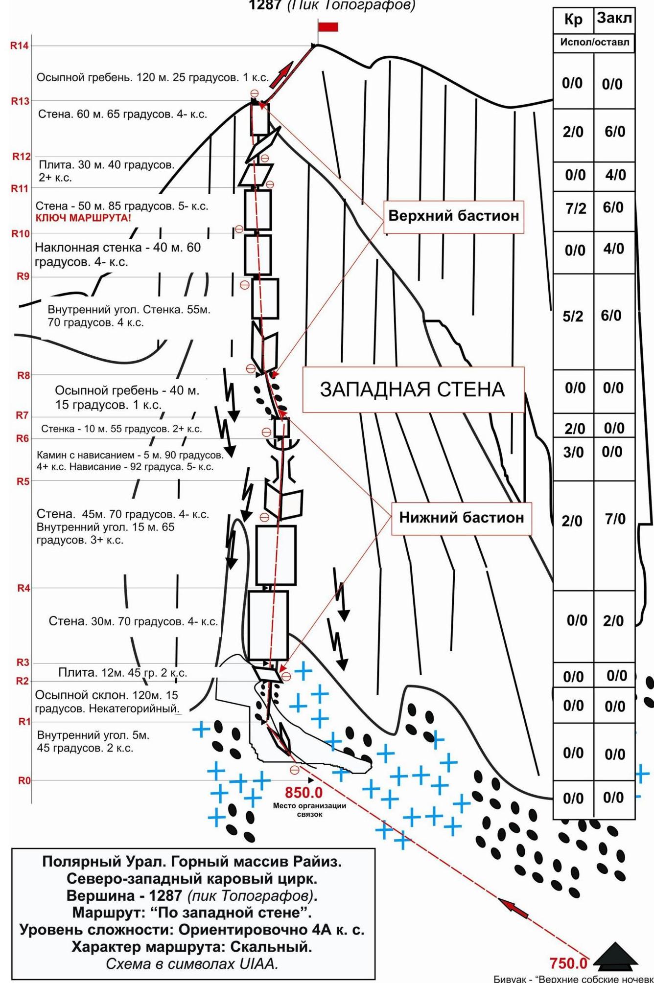
Polar Urals. Raiiz mountain range. Northwestern cirque. Peak — 1287 (Topografov Peak). Route: "Via western wall". Level of complexity: approximately 4A category of complexity (Rocky).
Photos:
- Photo1: lower part of the route taken from peak 1309 (Polarny Peak).
- Photo2: start of the technical part of the route.
- Photo3: second station.
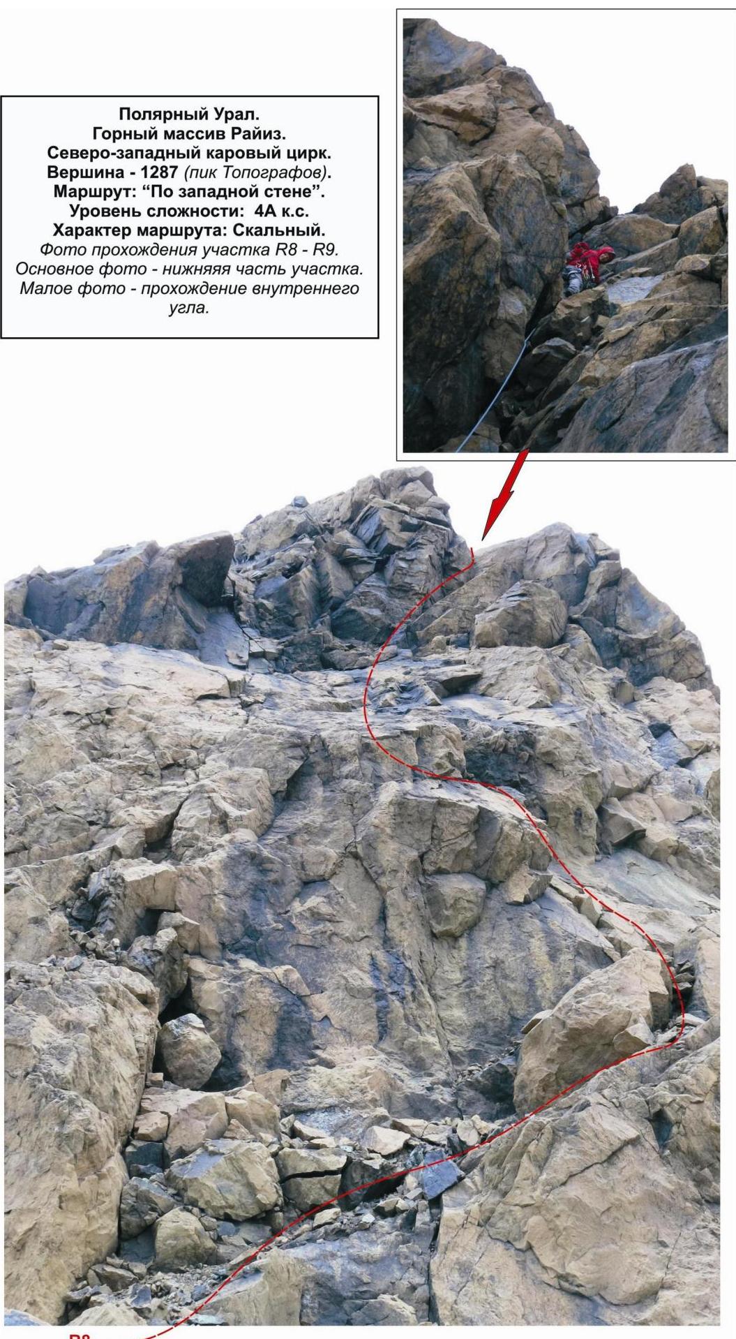
Polar Urals. Raiiz mountain range. Northwestern cirque. Peak — 1287 m (Topografov Peak). Route: "Via western wall". Level of complexity: 4A category of complexity. Character of the route: Rocky.
Photo of passing section R8–R9:
- Main photo — lower part of the section.
- Small photo — passing the inner corner