
Passport of the mountaineering route to the peak Starukha (1439) via the southern ridge, category 2B Natural Sports Complex (NSC) "Pripoiarnyi Ural" Natural Sports Ground (NSG) "Valley of the Balbanyu River"
| № | Administrative district of the Russian Federation | North-Western | |
|---|---|---|---|
| 2 | Subject of the Russian Federation | Komi Republic | |
| 3 | Administrative region | Inta district | |
| 4 | Natural Sports Complex (NSC) | "Pripoiarnyi Ural" | |
| 5 | Natural Sports Ground (NSG) | "Valley of Balbanyu" | |
| 6 | Mountain range | Issledovatelsky Ridge | |
| 7 | Mountain spur | Mountain horseshoe: peak Chernaya – peak Erkusei – pass Barkova – peak Starik – peak Starukha – pass Severnyi – pass Karpinsky – peak Narodnaya – peak Limbeiko. | |
| 8 | Mountain massifs within this NSG | 1. Issledovatelsky Ridge 2. Narodo-Inyinsky Ridge 3. Maldy-Nyrd Ridge 4. Sanaiz (Rosomakha) Ridge | |
| 9 | Peak (object of sporting ascent) | Starukha. Elevation 1439 m | |
| 10 | Route (object of sporting passage) | Southern ridge | |
| 11 | Time taken for the route | 10–14 hours from the base camp by Lake Maly Balbanty (reindeer herders' camp) | |
| 12 | Category of difficulty | 2B | From October 15 to June 15, abundant snow on the slopes, and icicles on the route. |
| 13 | Analogues of the route: | 1. Chegetkara 2B NE ridge (Kabardino-Balkaria, Adyl-Su gorge). 2. SKGMI from the east – 2B (Kaidzhany gorge, North Ossetia) | |
| 14 | Route features | Meets the requirements of a combined route (from October 15 to June 15), rock route (from June 15 to October 15) of category 2A. |
 Ascent Passport
- Region, gorge, section number according to KMGV
1.1. Region – Pripoiarnyi Ural. 1.2. Gorge – Valley of the Balbanyu River. 1.3. Section number according to KMGV-2001 – 8. "Other mountain systems, massifs".
- Name of the peak, elevation, name of the route
2.1. Name of the peak – Starukha. 2.2. Elevation – 1328 m. 2.3. Name of the route – via the southern ridge. 2.4. Proposed category of difficulty (variant, combination).
-
Proposed category 2B.
-
Nature of the route
4.1. Rock.
- Elevation difference, route length, length of sections of category 5, category 6, average steepness of the main part of the route, entire route
5.1. Elevation difference – 800 m. 5.2. Route length – 1500 m. 5.3. Sections of category 5 – none, category 6 – none. 5.4. Average steepness of the main (technical part) of the route – 65°. 5.5. Average steepness of the entire route – 45°.
- Pitons left on the route, including bolted ones, used on the route: rock climbing, quickdraws, закладок, used pitons: bolted stationary, bolted removable, НТО
6.1. No pitons left on the route. 6.2. Used: 5 horizontal rock pitons, 3 vertical rock pitons, 5 закладных elements, 5 safety loops. 6.3. Bolted pitons were not used.
- Team's working hours
7.1. Approach from the "Zhelannaya" base to the bivouac "Reindeer herders' camp by Lake Balbanty" – 3 hours. 7.2. Ascent from the bivouac "Reindeer herders' camp by Lake Balbanty" – 10 hours.
- Team leader – full name, sports rank, title, participants
8.1. S. Zhuravlev, Candidate for Master of Sports, 2nd instructor category. 8.2. Participants: * I. Vilekzhaninov – 3rd sports rank (Syktyvkar) * D. Severinova – 3rd sports rank (Syktyvkar) * P. Gayner – 3rd sports rank (Syktyvkar) * A. Panyukov – 3rd sports rank (Syktyvkar) * A. Shershov – 3rd sports rank (Yoshkar-Ola) 8.3. Note: We request the Classification Committee of the FAR to certify the group's first ascent as category 3A.
- Coach, full name, title, instructor qualification
9.1. Zhuravlev Sergey Vasilievich, Candidate for Master of Sports, instructor 2nd category.
- Departure on the route: hour, day, month, year. Summit, return to base camp
10.1. Departure on the route – 9:00, August 27, 2004. 10.2. Summit – 16:30, August 27, 2004. 10.3. Return to base camp – 20:30, August 27, 2004.
- Organisation
11.1. Monitoring expedition of the Alpinism Federation of the Komi Republic and the Directorate of the National Park "Yugyd Va" "Polar Vertical – 2004".
Contact: Zhuravlev Sergey Vasilievich, Gayner Polina Sergeevna, Syktyvkar, 167000, Internatsionalnaya St., 97, apt. 12, phone 24-24-91. E-mail: Zhur58@rambler.ru
Peak: Starukha (1439 m) Route: via the southern ridge, category 2B (rock) Natural Sports Ground (NSG) "Valley of Balbanyu" Natural Sports Complex (NSC) "Pripoiarnyi Ural"
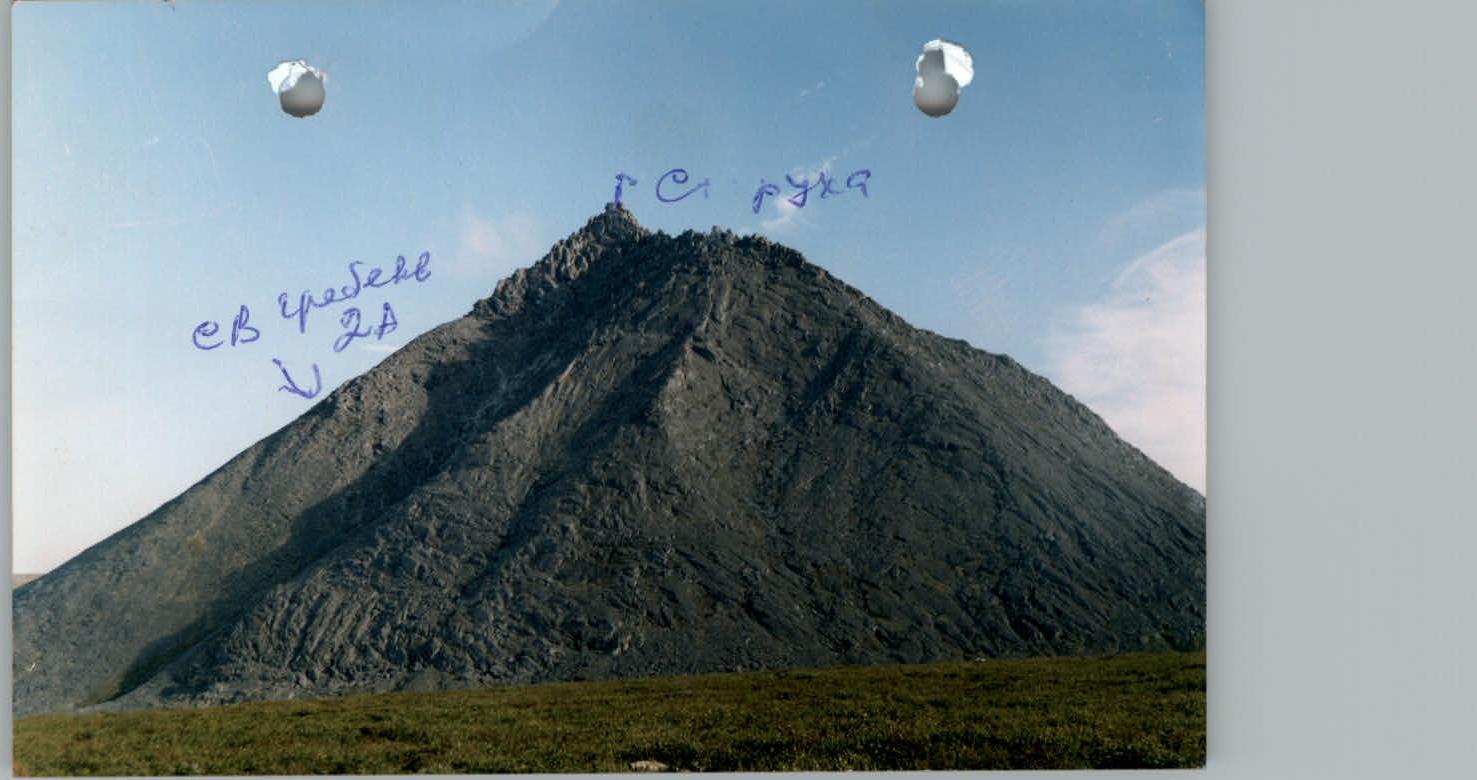
Tactical plan for the ascent via the NE ridge – category 2A.
R0–R1 – approach to the start of the route, to the scree "claw" at the base of the north-eastern ridge. (Tundra, scree, 45°, easy) R1–R2 – ascent to the shoulder. (Scree – 50–60°, easy) R2–R3 – ascent to the base of the rocky ridge under the "Lizard" pinnacle. (At the foot of the "Lizard" pinnacle is a control cairn). (Coarse scree 50–60°, easy) R3–R4 – movement along large rocky blocks to the left, bypassing the "Lizard" pinnacle. (Rock, 300–350 m, 60–65°, 1+, 2 category) R4–R5 – bypassing the "Crown" pinnacle to the left. Passage of an inclined wall. (Key to the route!). (Rock, 45 m, 3+ category) R5–R6 – traverse to the right along a rocky ledge. (Rock, 100 m, 1+ category) R6–R7 – traverse under a cornice with an exit to the ridge. (Rock wall 10 m, 90°, 3– category) R7–R8 – movement along the ridge to the base of an internal corner. (Rock, 80 m, 60–70°, 2+ category) R8–R9 – passage of the internal corner. (Rock, 60 m, 55–60°, 2+ category) R9–R10 – exit to the summit tower (central of three). (Rock, 30 m, 55–60°, 2+ category) R10 – peak Starukha.
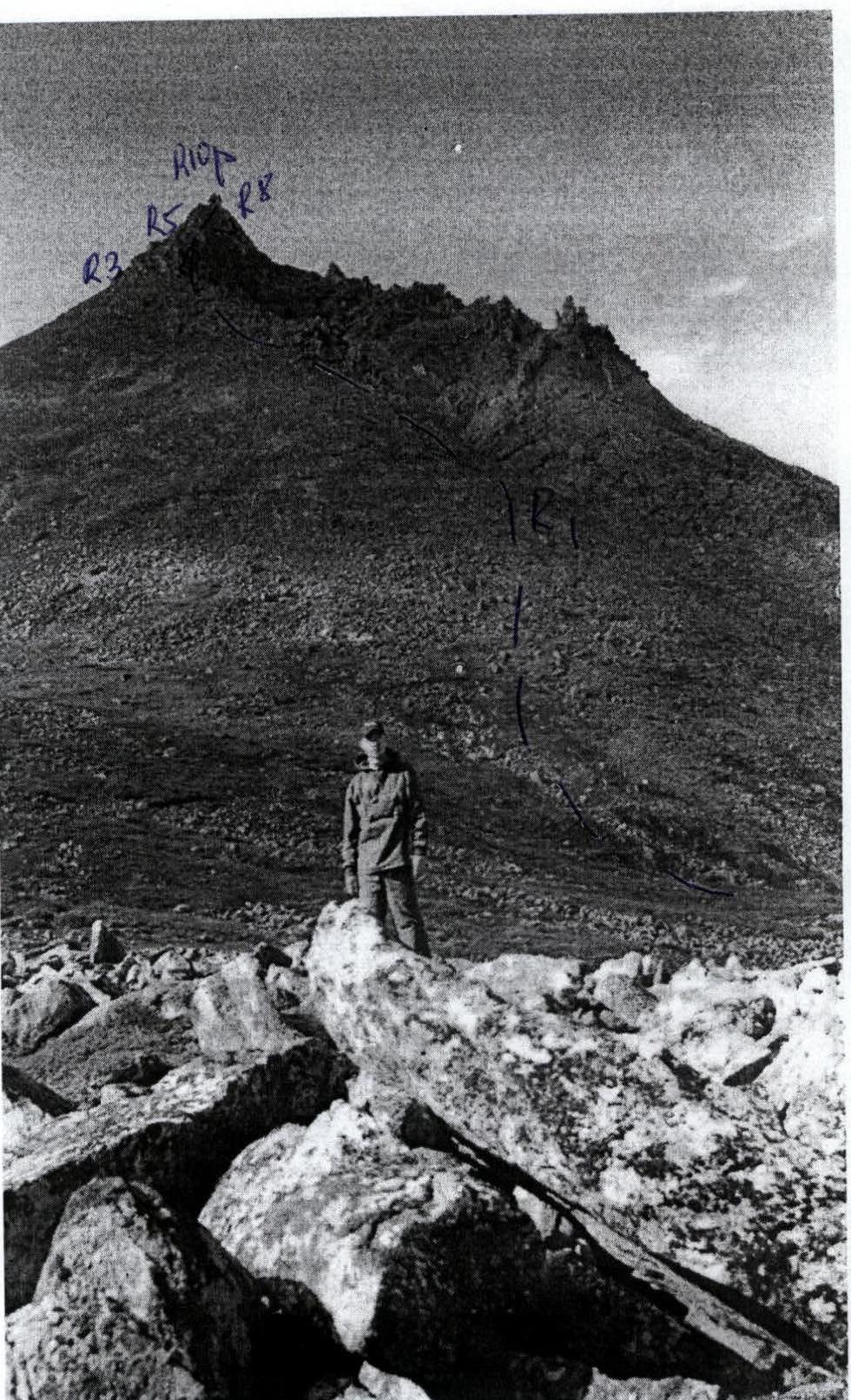
Tactical scheme for the passage of the route via the Southern ridge – category 2B.
R0 – bivouac near the reindeer herders' camp by Lake Verkhny Balbanty. R0–R1 – approach to the tract Lelya-Glad under the start of the route, to the scree eastern spur of the southern ridge. (Trail, tundra, boulders, 4 km, easy) R1–R2 – ascent onto the scree spur of the southern ridge. (Scree slope, slope steepness – 50–60°, easy) R2–R3 – internal corner "Book" (key to the route!). (Rock, 40 m, 70–75°. Level of complexity – 2+ category. At the exit from the internal corner – 7 m, 90°, 3+. Pitons ( закладная страховка)) R3–R4 – movement along a series of oblique, inclined rocky ledges through the "Gates", formed by two feathery pinnacles. (Rock, 150–200 m, steepness 45–50°, 2– category. Alternate belay) R4–R5 – overcoming the "Collapse". (Rock, level of complexity – 2+ category) R5–R6 – traverse to the right along a rocky ledge to the "Brick" block. (Rock, 100 m, 2 category) R6–R7 – exit onto the ridge of the counterfort. (Rock, wall – 10 m, 90°, 3–, 2+) R7–R8 – movement along the ridge of the counterfort with an exit onto the southern ridge. (Rock, 40 m, 65–70°, 2+, 2– category. Alternate belay) R8–R9 – movement along the ridge and traverse to bypass the southern summit tower. (Rock, 1 category) R9–R10 – exit onto the summit tower (central of three). (Rock, wall 30 m, 65–70°, 2+ category) R10 – peak Starukha.
Technical description of the route (ОСП)
Approach: From the base camp by Lake Maly Balbanty near the reindeer herders' camp, eastward along a cross-country vehicle road to the tract Lelya-Glad. Then upstream along the Lelya-Glad stream, first along a reindeer trail, then across boulders to approach the eastern spur of the southern ridge. The spur is scree-covered, with mosses and lichens. The approach takes around 1.5–2 hours. Then ascent along scree onto the southern ridge and approach along the heavily damaged scree ridge to the rocky tower of the peak. Many pinnacles on the ridge can be freely bypassed from different sides or "head-on" with simple climbing. It is necessary to form rope teams below the rocky tower.
Technical part of the route: Then, to the left along a simple inclined slab to the right, approach the "Book". "Book" is an internal corner tapering upwards with an overhang on the left. This is the key to the route. Climbing is complicated, with the upper part of the corner (7–10 m) being category 3.
Intermediate belay points:
- закладные elements: № 3–8, stoppers, hexes.
- Cracks for pitons – both horizontal and vertical.
The exit from the internal corner is onto smooth, almost horizontal slabs. On the ridge, there are enough protrusions for organising belays and securing ropes. Further movement is upwards along the ridge to the "Gates". "Gates" is a passage between two high pinnacles. Then, to the left along a series of inclined ledges, approach the "Collapse". "Collapse" is a rift in the ridge about ten metres deep and about one and a half metres wide. For training and sports groups of climbers (НП-2), it is recommended to rig ropes for overcoming the "Collapse". After the "Collapse", move rightward along the ridge on a series of ledges to a rocky block "Brick". The block lies obliquely in an internal corner formed by the southern ridge and the eastern counterfort of the southern ridge. A good landmark is the "Tunnel", a natural through passage in the ridge. From the "Tunnel", traverse rightward along the ridge to a rocky wall of the counterfort, which is overcome by climbing. Section 10 m, 3 category. Then along the ridge of the counterfort upwards on rocks 2+ to an exit onto the ridge. Alternate belay. For training and sports groups, rigging ropes is required. Then, to the right along the ridge – bypassing the southern summit tower. There are three towers. The summit is the central rocky tower.
Descent is by the ascent route. Time taken to complete the route (with return to the base camp) by a training and sports group – 10–12 hours.
Required equipment (calculated for a training and sports group НП-2 of 6 people):
- Climbing ropes 3 × 40 m.
- закладные elements – 10 (full set of stoppers).
- Rock pitons – 7.
- Belay loops – 5.
- Quickdraws – 10.
For training and sports groups НП-2, it is recommended to take a tent, a primus stove, and a pot on the route. Additionally, consider that in the summer, there is no water on this rocky route, so it needs to be carried.
Comments
Sign in to leave a comment