Passport
- Section number according to KMGV — 2010 — 8.3.50
Polar Urals, Raiiz mountain massif, Nyrdvomen-Shor stream valley
- Name of the summit: 1134 (Raiiz Northern)
height: 1134 m, route: via the southwest slope.
- Category of difficulty: proposed 1B cat. diff., PP.
- Nature of the route — winter.
- Height difference of the route: 728 m
- Length of the route: 2500 m
- Length of sections with the highest cat. diff.:
1 cat. diff. — 3 sections — 2200 m, 2 cat. diff. — 2 sections — 120 m, 3 — 0 m, 4 — 0 m, 5 — 0 m, 6 — 0 m.
- Average steepness: main part of the route — 45 degrees.
9. Pitons used:
Total used on the route:
- ice screws — 8 pcs.
- rock pitons — 0
- chockstones — 0
- stationary pitons — 0
- ITO — 0
- removable pitons — 0. Pitons left on the route: total 0; incl. stationary pitons — 0.
- Start of the route — 5:00, March 10, 2011
Summit reached — 15:00, March 10, 2011. Return to BL — 18:00, March 10, 2011
- Team's walking hours: — 13 h.
- Leader: Khramtsov V. A. (1st sports category, Ukhta).
Participants:
- A. Seleznev (3rd sports category, Ukhta)
- A. Golovnya (3rd sports category, Ukhta)
- E. Donyushko (2nd sports category, Ukhta)
- S. Maltsev (1st sports category, Ukhta)
- Coach: Zhuravlev Sergey Vasilyevich, title — CMS, instructor-methodologist 1st category.
Note: The sports group classified the regularly visited route to v. 1134 (Raiiz Northern) via the southwest slope, which was climbed and освоенный in the late 1970s for mass ascents. V. Khramtsov, methodologist at Ukhta Center for Additional Education.
Description of the summit
The summit 1134 (Raiiz Northern) is located in the Yamalo-Nenets National District (YNAO) of Tyumen Oblast, Ural Federal District of the Russian Federation, 30 km southeast of the 110 km halt (formerly Polar settlement), in the valley of Nyrdvomen-Shor stream (a large right tributary of the Sob river), on the eastern slopes of the Polar Urals, and is the highest summit of the Raiiz plateau. The summit is dome-shaped, height — 1134.0 m.
The summit 1134 (Raiiz Northern) can be an object for training and sports ascents, as it has:
- a number of pronounced rocky ridges;
- steep slopes.
The name of the mountain is official and can be found on maps of the Polar Urals; the orographic clarification of the summit (Northern) is given for the convenience of orientation for climbers, since the main summit of Raiiz (1097) — a plateau-like mountain with a vast summit plateau (about 26 km in diameter) — is lower than Raiiz Northern.
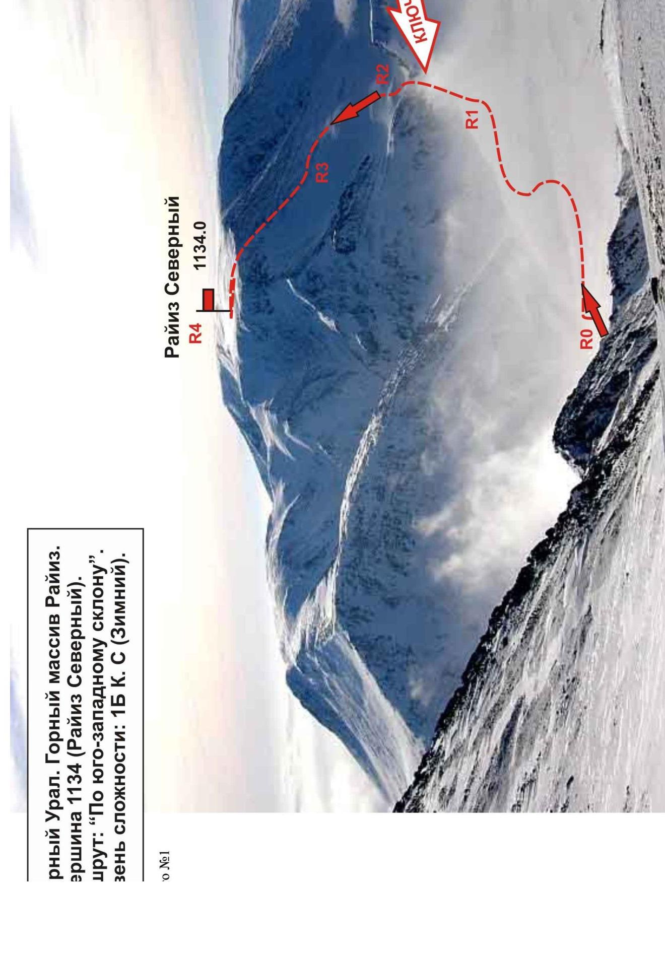
Description of the route: (via the southwest slope) (winter).
Route: "Via the southwest slope (winter)" — a typical winter training route of 1B cat. diff., having a minimal set of natural obstacles. Climbing this route has not only aesthetic but also sports-practical significance, as it allows working out belaying and self-belaying techniques on snow and ice relief within the ascent. The route is logical in orientation, objectively safe, which allows conducting training and sports ascents in winter.
The route "Via the southwest slope" 1B cat. diff. is one of the classic ascents to the highest peak of the Raiiz mountain — 1134 (Raiiz Northern). It is regularly used not only for training purposes but also for mass ascents during alpinadas.
Equipment
For an ascent as part of a training and sports group of 6 people (5 participants + instructor) on the route, the following special equipment is required:
-
Personal — standard, crampons and ice axe — mandatory
-
Group:
- main rope 10 mm — 3 pcs. x 50 m
- chockstones — 4 pcs.
- rock pitons — 4 pcs.
- ice screws — 8 pcs.
- quickdraws — 8 pcs.
- slings — 6 pcs.
- ice axe — 1 pc.
Approach
The route starts immediately from the base camp — abandoned geologists' cabins (Nefritovyi Stream camp).
Technical part
From the base camp — "Geologists' cabins 'Nefritovyi Stream'" — walk along the Nefritovyi stream valley, traversing the slope at 1000 m (area of the northern minor one), to the entrance to the canyon.
Then — the beginning of the technical part, passing the key point of the route — the frozen Nefritovyi stream waterfall. The key of the route — passing two ice steps in the Nefritovyi stream canyon.
Then:
- Exit to the southwest slope
- Ascent along the snowy slope to the heavily destroyed rocky ridge
- Ascent along the simple rocks of the ridge to the summit scree dome
A cairn is installed at the exit of the ridge to the summit plateau.
Descent from the summit
Descent via the ascent route. Polar Urals. Raiiz mountain massif. Summit 1134 (Raiiz Northern). Route: "Via the southwest slope". Cat. diff. 1B (winter).
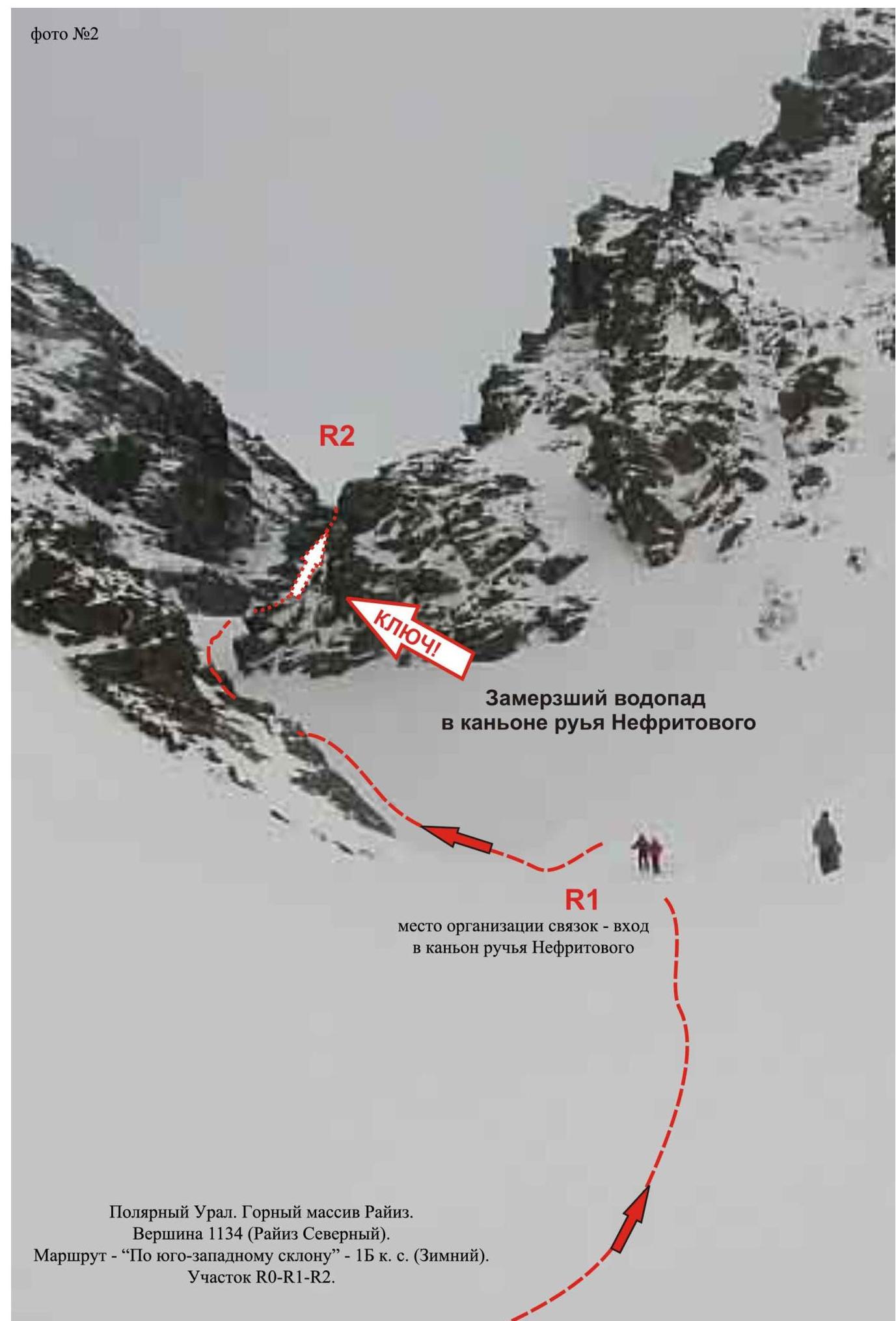
Polar Urals. Raiiz mountain massif. Summit 1134 (Raiiz Northern). Route — "Via the southwest slope" — cat. diff. 1B (winter). Section R0–R1–R2.
Polar Urals. Raiiz mountain massif. Summit — 1134 (Raiiz Northern). Route — "Via the southwest slope" — cat. diff. 1B (winter). Section: R1–R2 — key point of the route — frozen waterfall in the Nefritovyi stream canyon. First ice step.

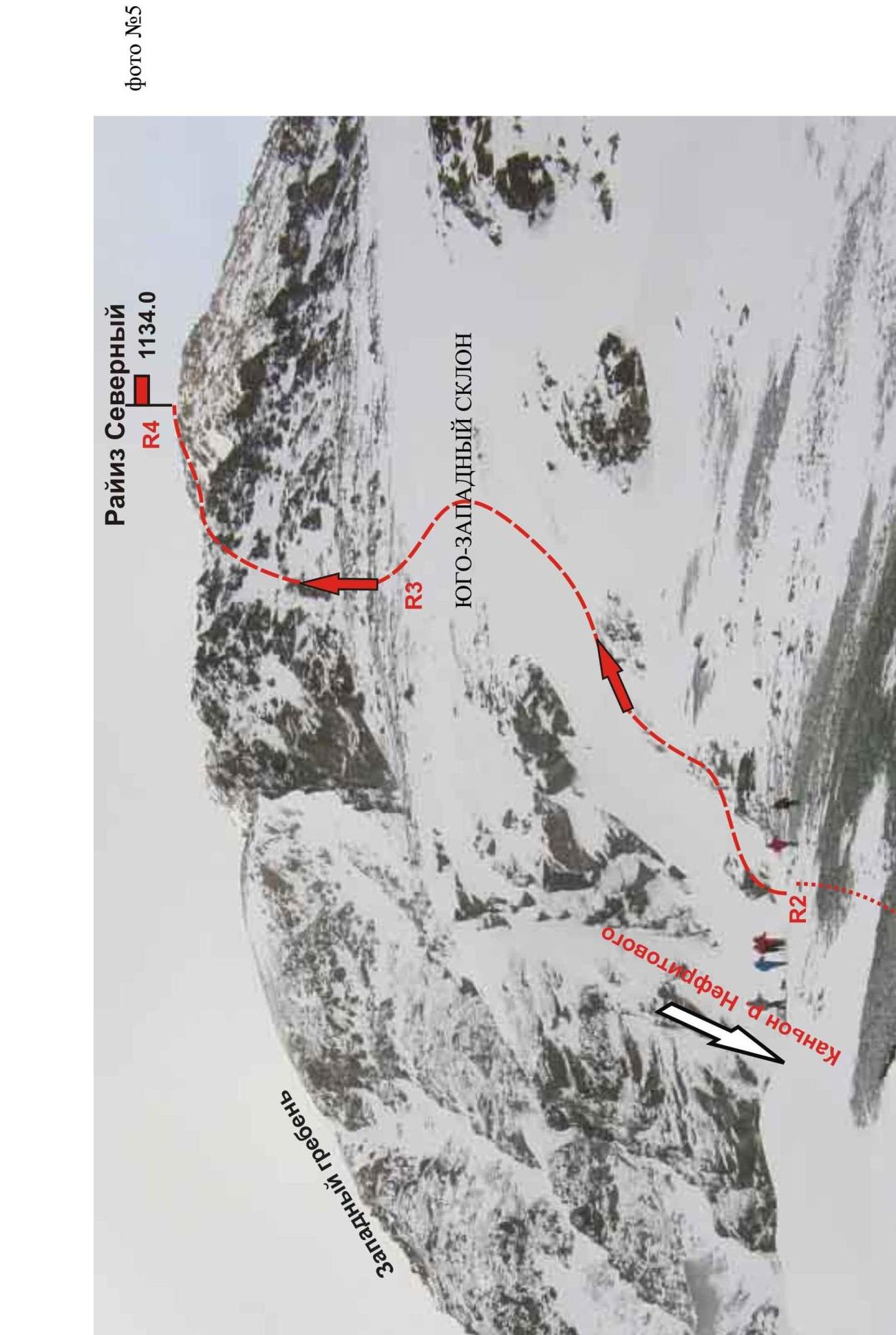
Polar Urals. Raiiz mountain massif. Summit 1134 (Raiiz Northern). Route: "Via the southwest slope". Level of difficulty — 1B cat. diff. (winter)
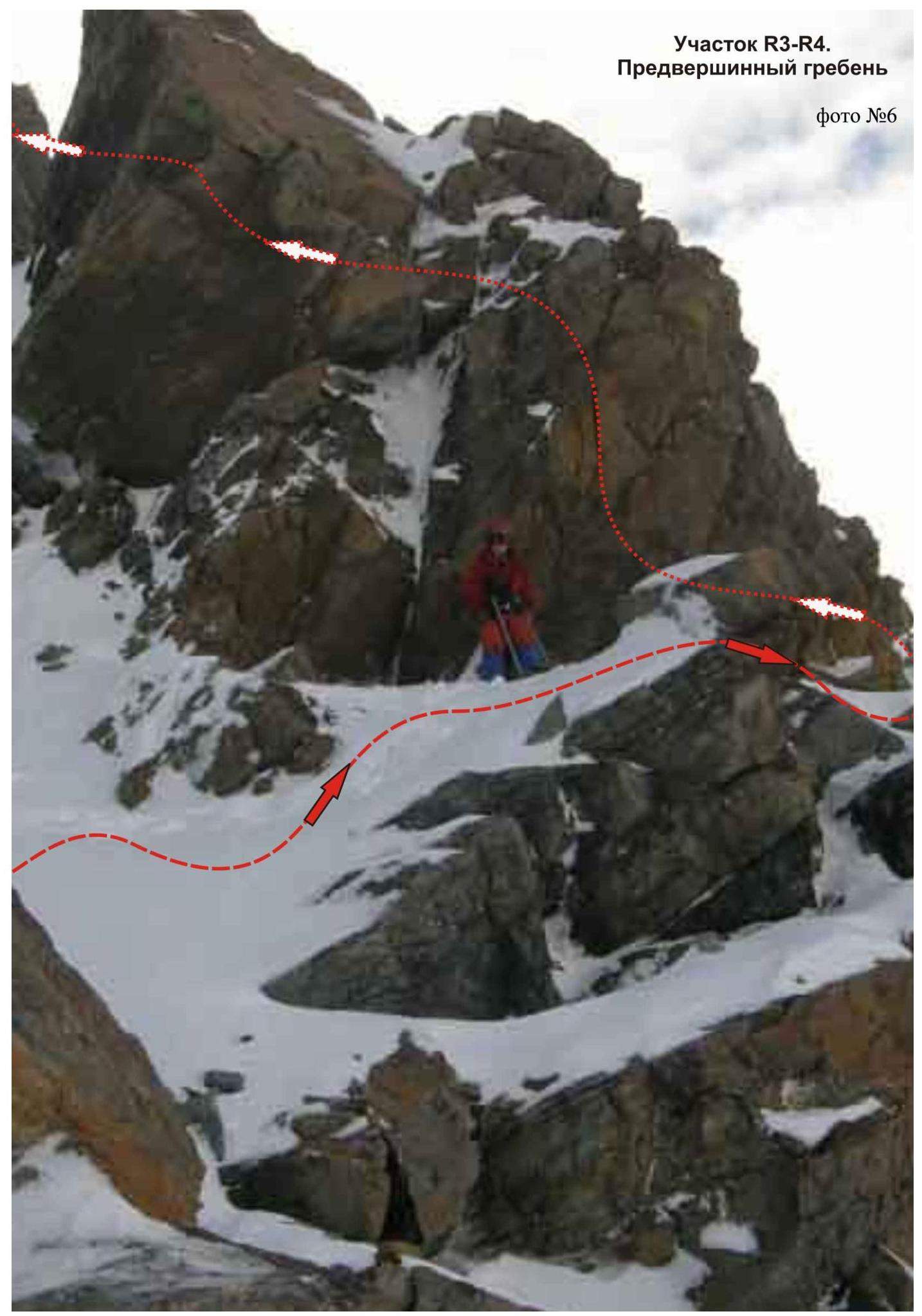
Section R3–R4.
Pre-summit ridge
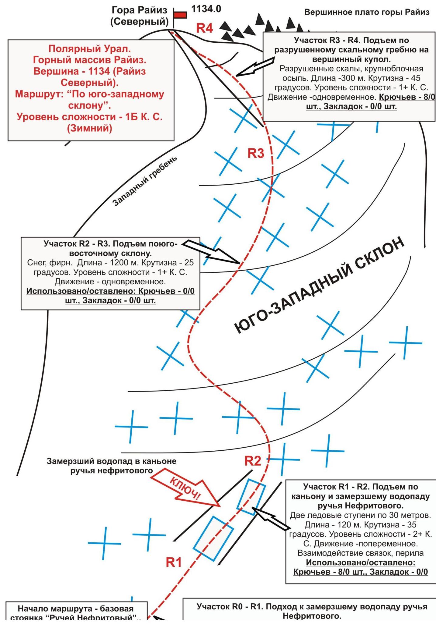
Start of the route — base camp "Nefritovyi Stream"