Ascent Passport
Mountain region — Polar Urals Ridge — Rai-Iz mountain massif Gorge — Nyrdvomen-Shor river valley. Section number according to KMGV-2001 — #8. "Other mountain systems and massifs". Name of the peak — Rai-Iz Height — 1057 m Route name — via the western ridge Complexity category — 1B cat. diff. Route type — rock Height difference — 520 m (according to the map of the General Staff of the Russian Federation: initial mark — 199 m, summit — 1057 m). Route length — 6–8 km Technically difficult sections:
- sections of 5 cat. diff. — none
- sections of 6 cat. diff. — none Average steepness of the route — 35°, technical part of the route (40 m of the key section) — 65°. Pitons on the route:
- left — 0
- used — 2 pcs.
- chocks — 4 pcs. Team's travel hours — 10 hours Group composition — leader S. V. Zhuravlev (Candidate for Master of Sports, instructor-methodologist 2nd category, Syktyvkar) + 10 participants. Exit to the route — 6:00, June 27, 2007. Reaching the summit — 12:00, June 27, 2007. Return to the base camp — 16:00, June 27, 2007. Organizations conducting the alpine event:
- Alpine expedition of the Alpinism Federation of the Komi Republic
- Non-commercial Partnership "Club of Northern Travels 'Sauk-Pai'" (Syktyvkar)
- Club of tourists and alpinists of Ukhta Dates of the alpine event — from June 25 to July 10, 2007.
Senior coach — releasing FARK (Alpinism Federation of the Komi Republic) F. N. Fomenko (Candidate for Master of Sports, instructor-methodologist 1st category, ud. # 07, Ukhta)
Senior coach — releasing alpine event S. V. Zhuravlev (Candidate for Master of Sports, instructor-methodologist 2nd category, ud. # 1124, Syktyvkar)
Alpinism Federation of the Komi Republic Syktyvkar, 2007.
Route Description
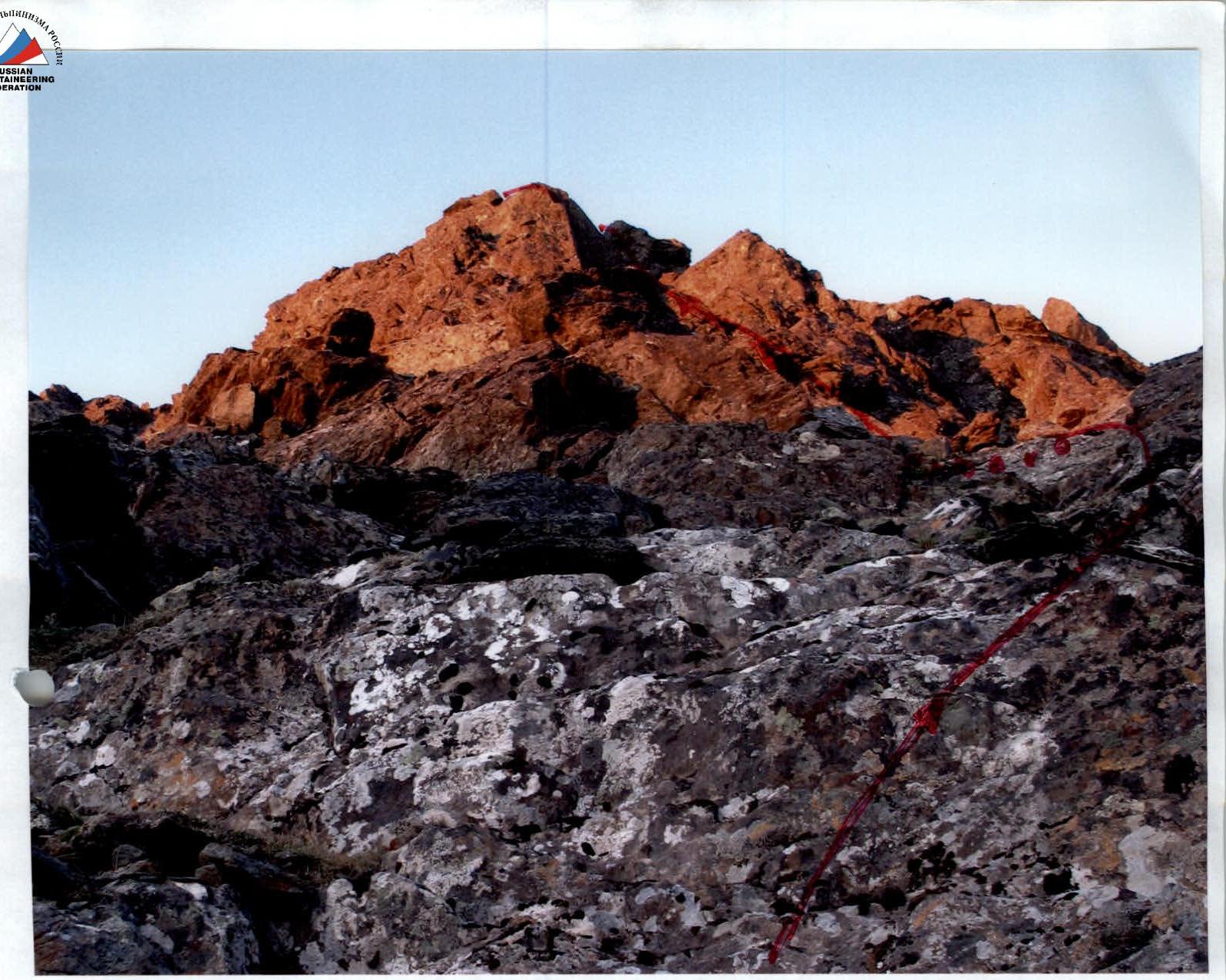
Route: "Via the western ridge" is clearly visible from the confluence of the Nefritovyi and Nyrdvomen-Shor streams. The western ridge is well-defined. The start of the route is marked on the rocky talus slope of the ridge.
Approaches: Moving from the bivouac in the Nyrdvomen-Shor river valley (see attached map), along the all-terrain vehicle road, ascend to the abandoned geologists' cabins. The cabins can serve as an intermediate base camp for the ascent.
- The approach from the base camp in the Nyrdvomen-Shor river valley to the cabins takes 3–4 hours.
- From the cabins to the talus slope of the western ridge — the start of the route — is no more than half an hour's walk along the Nefritovyi stream valley.
- The western ridge runs along the left bank, just before the Nefritovyi waterfall canyon.
Technical part of the route:
The start of the route is a layer of black shales, easily passable with gymnastic belay.
Further:
- Ascend along the green talus ridge to the first rocky shoulder.
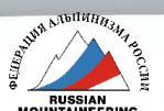
The first rocky shoulder is the key to the route. This is a strip of dense rocks, passable along a wall of medium complexity. Psychologically challenging for novices, but confidently passable.
After reaching the first rocky shoulder:
- Move along the large blocks of the ridge.
- Then — along the heavily serrated ridge to the second rocky shoulder.
The second rocky shoulder is technically simpler than the first. After ascending it along the large-block talus, you reach the talus dome of the Rai-Iz summit.
Second rocky shoulder R5–R6
The summit is poorly defined, a cairn is built at the exit of the ridge onto the summit plateau. Descent from the summit — safest along the ascent route to the first rocky shoulder. Further:
- Left along the snowfields to the terrace above the Nefritovyi stream canyon.
- Traverse along the rocky ledges of the black shale layer back to the western ridge and descend to the Nefritovyi stream.
- Then along the Nefritovyi stream valley to the geologists' cabins and down the all-terrain vehicle road to the base camp in the Nyrdvomen-Shor river valley.
Equipment: for a group of 10 people:
- Main rope — 2 pcs., 10 mm × 50 m
- Rock pitons — 3 pcs.
- Chocks — 5 pcs.
- Stationary loops — 2 pcs.
- Carabiners — 5 pcs.
- Primus (gas burner) — 1 pc.
- Cooking pot — 1 pc.
- Personal standard equipment — for each participant.
Description of the summit
The Rai-Iz summit (1057) is the main peak of the Rai-Iz mountain massif in the Polar Urals, within the Yamalo-Nenets Autonomous Okrug of the Russian Federation, beyond the Arctic Circle.
The only classified route to the Rai-Iz summit. The route was traversed and classified by Ukhta alpinists as a winter route. It is proposed for classification as it meets the requirements for educational and sports routes in the summer as well.
The Rai-Iz summit (1057) is not ярко выражена, but represents a characteristic plateau for the Polar Urals, bounded on different sides by talus and rocky slopes. Nevertheless, on geographical maps, it defines the name of the entire mountain massif.
UIAA sign diagram

| Section | Length | Steepness | Complexity | Pitons | Chocks | Photo # |
|---|---|---|---|---|---|---|
| R8 | ||||||
| R7 | 50 m | 45° | 1+ cat. diff. | 0 | 0 | |
| R6 | 30 m | 55° | 2+ cat. diff. | 0 | Loops — 6 | #3 |
| R5 | 200 m | 45° | 2–, 2+ cat. diff. | 0 | 0 | # |
| Key R4 | 45 m | 65° | 3 cat. diff. | 3 | 4 | #1, #2 |
| R3 | 700 m | 35° | 1–, 1+ cat. diff. | 0 | 0 | # |
| R2 | 150 m | 30° | N/C | 0 | 0 | # |
| R1 | 600 m | 15° | N/C | 0 | 0 | # |
Symbol "Key" for section R4
Technical description of the ascent diagram in UIAA signs
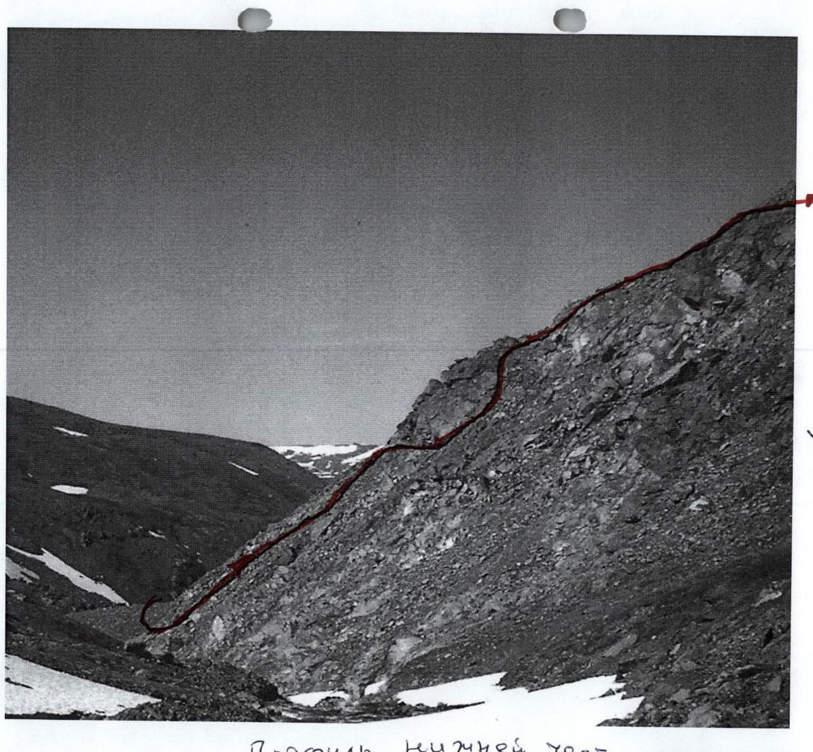
R0 — base camp in the larch oasis of the Nyrdvomen-Shor river. R0–R1 — Base camp — geologists' cabins. All-terrain vehicle road. Section length — 8 km. Complexity level — non-categorized.
R1–R2 — Approach to the start of the route to the base of the western ridge under the black shale layer. Mountain tundra, talus, scree. Crossing by stones (snow bridges) over the Nefritovyi stream. Section length — 1500 m. Section steepness: initially 14°. Complexity level — non-categorized.
R2–R3 — Ascend along the black shale layer to the green talus ridge. Destroyed shale rocks. Section length — 150 m. Section steepness — 45–50°. Complexity level — 1 cat. diff. Belay during movement along large rocky blocks — gymnastic.
R3–R4 — Passage along the green talus ridge. Scree.
- Section length — 400 m.
- Steepness — 30°.
- Complexity level — 1+, 1– cat. diff. Scree. Medium and large blocks.
- Section length — 300 m.
- Section steepness — 30°.
- Complexity level — 1+, 1– cat. diff.
- Simultaneous movement of participants.
R4–R5 — Passage along the wall of the first rocky shoulder. Exit to the first rocky shoulder. Monolithic rocks. Section length — 45 m. Section steepness — 65°. Complexity level — 3 cat. diff. Group movement with alternate belay. Peril organization.
R5–R6 — Movement along the ridge, composed of large rocky blocks. Approach to the second rocky shoulder. Rocky ridge. Section length — 200 m. Section steepness — 45°. Complexity level — 2–, 2+ cat. diff. Alternate movement. Belay on ledges.
R6–R7 — Passage along the rocky wall of the second rocky shoulder. Monolithic rocks. Section length — 50 m. Section steepness: in the lower part — 25°. Complexity level — 2+ cat. diff. Alternate movement. Piton belay, using chocks. Exit to the second rocky shoulder.
R7–R8 — Exit along the talus ridge to the talus dome of the Rai-Iz summit. Large-block talus. Section length — 50 m. Complexity level — 1 cat. diff., alternate.
R8 — Rai-Iz summit (1057). R8–R0 — descent along the ascent route.
Route map of the upper stage of the route