Passport
- Section number according to KMGV — 2010 — 8.3.44
Polar Urals, Raiiz mountain range, Sob River valley
- Name of the peak: 1309.0 (Polar Peak)
height: 1309.0 m route: Western ridge.
- Category of difficulty: proposed 1Bz, pp.
- Character of the route — combined.
- Height difference of the route: 540 m
- Length of the route: 4100 m
- Length of sections with the highest category of difficulty:
R1–R1500 m, R2–R2600 m, R3–0 m, R4–0 m, R5–0 m, R6–0 m.
- Average steepness: main part of the route — 50 degrees.
total route — 45 degrees.
9. Number of pitons used:
Total number used on the route:
- Rock pitons — 0
- Chocks — 0
- Stationary bolt pitons — 0
- Ice screws — 0
- Removable bolt pitons — 0
Number of pitons left on the route: total — 0; including bolt pitons — 0.
- Departure on the route — 7:00, March 10, 2006
Reached the summit — 15:30, March 10, 2006 Returned to Base Camp — 17:00, March 10, 2006
- Team's total climbing hours: 8 hours.
- Leader: Goletarov Andrey Mikhailovich (2nd sports category, Inta).
Team members:
- L. Kaneva (3rd sports category, Syktyvkar)
- E. Burtsev (3rd sports category, Syktyvkar)
- K. Tostilikov (3rd sports category, Syktyvkar)
- Coach: Zhuravlev Sergey Vasilyevich, title — CMS, instructor-methodologist 1st category.
Description of the peak
Peak 1309 (Polar Peak) — one of the peaks in the Raiiz mountain range, located in the Yamalo-Nenets Autonomous Okrug (YNAO) of the Tyumen Oblast, Ural Federal District of the Russian Federation, on the eastern slopes of the Polar Urals, on the northwest of the Raiiz mountain range, on the watershed of the mountain valleys of the rivers:
- Nyrvomen-Shor (north),
- Sob (west),
- Enga-Yu (southeast).
The peak is a pronounced rocky pyramid, height — 1309.0 m. The name is unofficial but has become established in the tourist and mountaineering community.
Peak 1309 (Polar Peak) can be an object for training and sports ascents, as it has several pronounced rocky ridges.
Description of the route: "Via the Western ridge 2A (combined)"
Route: "Via the Western ridge 2A category of difficulty (combined)" — a typical training route of the second category of difficulty, with a full range of natural obstacles corresponding to routes of this level of difficulty.
Climbing this route has not only aesthetic but also practical training value, as it allows climbers to practice techniques such as:
- Belaying
- Self-belaying on rocky and snowy-icy terrain
The route is ridge-like, allowing for training ascents both in winter and summer.
Equipment
For a climb by a team of 6 people (5 participants + instructor) on a training route, the following special equipment is necessary:
Personal (standard):
- Crampons — required
- Ice axe — required
Group equipment:
- Main rope 10 mm — 3×50 m
- Rock hammer — 1 piece
- Rock pitons — 6 pieces
- Ice axe — 1 piece
- Chocks — 6 pieces
- Ice screws — 6 pieces
- Quickdraws — 6 pieces
- Loops — 8 pieces
Approach
Approach from the Polar Urals train station on the Northern Railway along the Sob River valley:
- in winter on skis,
- in summer on an all-terrain road,
- to the "U ozera" bivouac,
- into the cirque formed by the western ridge of peak 1309 (Polar Peak), a common rocky ridge to the east and the western ridge of peak 1287 (Topografov Peak), takes 4–6 hours. A base camp can be conveniently set up by the lake ( altitude mark of the lake's water edge is 667.0 m) on the talus fields of the mountain tundra. (Cooking on primuses and gas burners). From the lake, located at the foot of the mountain, the route begins.
Technical part
From the lake, ascend through a couloir to the lowering of the western ridge, then move along the ridge.
A long rocky ridge is covered with 3–4 cm of ice in winter (very hard in winter). Rocks of 2nd category of difficulty with short sections — slabs and walls of 3rd category of difficulty up to 5–10 m high. The ridge is pyramid-shaped, without sharp drops in height in the lower sections.
Movement is carried out with alternating belays, intermediate points — ridge outcrops, large stone blocks. The ice depth is insufficient for using ice screws, and using chocks is difficult due to cracks filled with ice.
Key to the first part of the traverse:
- Traversing the ridge with sections of iced rocks.
- Exit to the summit dome.
In summer, when climbing rocks, skills are required for passing rocky sections of 3rd category of difficulty on relatively small ridge walls up to 5–7 m, and in winter, the difficulty lies in "sugar heads" — dense snow drifts typical of the Arctic region, when passing which:
- Using ice screws is useless.
- Ice axe does not get stuck.
(Climbing groups are recommended to bring special tubular firn pitons on the route.)
Further, from peak 1309 (Polar Peak), descend along the snowy ridge to the Yuzhny Karovyy pass. From the Yuzhny Karovyy pass, ascend along a well-defined snowy rocky ridge to peak 1287 (Topografov Peak).
The key to the second part of the traverse — the last 50 m of the ascent to the rocky tower of the summit:
- Technically difficult climbing in crampons on iced rocks.
- Ice accretion.
- Minimal opportunities for organizing reliable intermediate belay and self-belay points.
Descent from the summit
Descent from the summit along the northwest ridge of peak 1287 to the pass col. Then — along a flattening couloir, descend into the western karovyy cirque.
The route is long and requires participants to have:
- knowledge and skills for moving on various forms of mountain terrain;
- diverse skills for organizing belays and self-belays.
Polar Urals. Raiiz mountain range. Peak — 1309 (Polar Peak). Route: "Via the Western ridge" (Photo — exit to the summit tower). Level of difficulty — 2A category.
(Combined).
R0 — start of the route. Bivouac "U ozera" (altitude mark — 767.0). R0–R1 — ascent to the lowering of the western ridge. Talus, snowy slope. 1500 m. Steepness up to 45°. Level of difficulty — categorized. Simultaneous movement on a shortened rope.
R1–R2 — traversing the western ridge to the pass col. Rocks. Ridge. 2000 m. Steepness 25°, when passing individual rocky sections up to 2–10 m, steepness up to 70°. Level of difficulty — 2–, 2+ category.
Movement:
- Simultaneous on a shortened rope, belay — by laying the rope around outcrops
- In some cases — alternating belay
R2–R3 — ascent from the pass col of the western ridge to peak 1309 (Polar Peak). Rocky ridge. Ice accretion. Dense snow-ice drifts ("Sugar head"). 600 m. Steepness — 45–55 degrees. Level of difficulty — 2−, 2+ category. On individual sections (up to 3–5 m — 3−, 3+ category) — alternating belay. When exiting to the summit tower — 100 meters — fixed rope.
Descent from the summit to the Yuzhny Karovyy pass. Snowy rocky ridge. Ice accretion. Dense snow-firn drifts ("Sugar head").
Descent from the summit tower using rappel (4 ropes), then — with alternating belay.
From the Yuzhny Karovyy pass, descend into the western karovyy cirque along a flattening couloir of 2–, 1+ category. Does not present difficulties. In case of bad weather, it is possible to hang rappel lines (4 ropes).
Peak Polarny
Section R2–R3
Ascent to peak 1309.0 (Polar Peak) — snowy rocky ridge. Ice accretion. Snow-firn drifts ("Sugar head").
- Length — 600 m
- Steepness — 45–55 degrees
- Level of difficulty — 2–, 2+ category.
On individual sections up to 5–7 meters:
- Steepness up to 70°
- Difficulty — 3–, 3+ category.
Movement with alternating belay, in case of necessity — interaction of rope teams, organization of fixed ropes.
Section R1–R2
Ascent along the western ridge to the pass col. Ridge. Length — 2000 m, average steepness — 25°, on icy sections up to 5–19 m — up to 70°. Level of difficulty — 2–, 2+ category. Movement is simultaneous, on a shortened rope. Sometimes — alternating.
767.0
Start of the route — bivouac "U ozera" in the western cirque of Polar Peak
Polar Urals. Raiiz mountain range. Peak 1309 (Polar Peak)
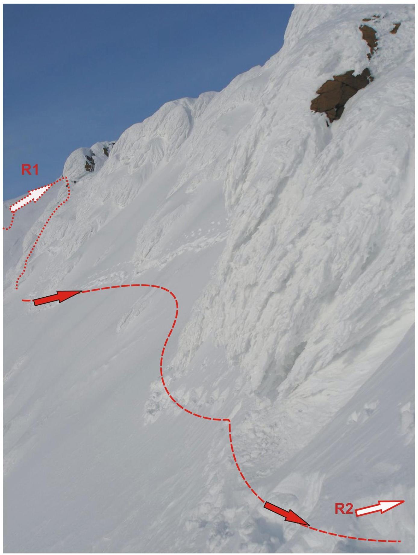
Peak 1309 (Polar Peak) Route: "Via the Western ridge" 2A category. Section
- R1–R2 — traversing the western ridge to the pass col.
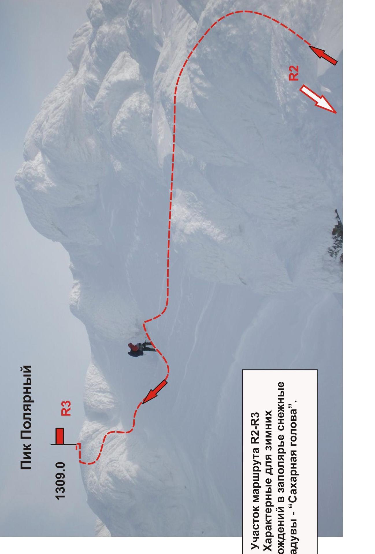
Peak Polarny
1309.0
R3
Section of the route R2–R3
Typical snow drifts for winter ascents in the Arctic region — "Sugar head".