
Ascent Passport
Region – Subpolar Urals. Ridge – Narod-Ityinsky Ridge (kряж). Valley – Bolshaya Lemva River Valley. Mountain massif – Parnokaiz. Section number according to KMGV-2001 – #8. "Other mountain systems, massifs". Peak name – 1152 (Pernayz). Height – 1152 m. Route name – via the eastern spurs of the southeast slope. First ascent. Proposed difficulty category for inclusion in the KMGV of the Russian Alpine Federation – 2A cat. (rocky). Note: The Alpine Federation of the Komi Republic requests the classification commission of the FAR to credit the group of pioneers for the ascent of 2B cat.
Elevation gain – 580 m. Route length – 2000 m. Average steepness of the main (technical) part of the route – 55°. Average steepness of the entire route – 40°. Technically difficult sections – sections 3, 4, 5 and higher cat. – none. No hooks left on the route.
Time spent by the team on the ascent:
- Approach to the base camp (conserved geologists' base "Lemva") from the miners' settlement Pachvoz – 2 days.
- Ascent from the base camp – 10 hours. Leader: Vorotilin Vyacheslav Nikolaevich, NP-1,2 team commander (Candidate for Master of Sports, instructor 1st category – cert. # 2423, Voronezh)
Participants:
- Kondratieva N. D. (3rd sports category, Syktyvkar)
- Kondratieva A. S. ("Alpinist of Russia" badge, Syktyvkar)
- Sivkov D. I. ("Alpinist of Russia" badge, Syktyvkar)
- Boyko I. A. ("Alpinist of Russia" badge, Syktyvkar)
- Rasputin A. V. ("Alpinist of Russia" badge, Syktyvkar)
- Ignatov E. M. ("Alpinist of Russia" badge, Syktyvkar)
Coach – Vorotilin Vyacheslav Nikolaevich (Candidate for Master of Sports, instructor 1st category – cert. # 2423, Voronezh)
Senior coach – Fomenko Felix Nikolaevich (Candidate for Master of Sports, instructor 1st category – cert. # 7, Ukhta)
Departure onto the route – 8:00 AM on August 12, 2006. Reached the summit – 2:15 PM on August 12, 2006. Return to the base camp – 4:00 PM on August 12, 2006.
Alpinist event: Volunteer Youth Scientific-Sports Alpine Expedition "Heights of the Native Land – 2006", dedicated to the 85th anniversary of the Komi Republic statehood.
Expedition organizers:
- Alpine Federation of the Komi Republic
- Non-profit partnership "Club of Northern Travels 'Sauk-Pai'"
- Club of Tourists and Climbers of Ukhta
Executed by: Vorotilin V. N., Zhuravlev S. V., Kondratieva N. D. Syktyvkar, 167000, Internatsionalnaya St., 97, apt. 12. Phone: 8 (8212) 24-24-91. E-mail: Zhur58@rambler.ru
Alpine Federation of the Komi Republic, NP "Club of Northern Travels 'Sauk-Pai'", Club of Tourists and Climbers of Ukhta
Report on the First Ascent
Mountain region: Subpolar Urals Valley: Bolshaya Lemva River valley Ridge: Narod-Ityinsky Ridge (kряж) Mountain massif: Parnokaiz Peak: 1152 (Pernayz) Route: via the eastern spurs of the southeast slope Proposed difficulty category for inclusion in the KMGV of the Russian Alpine Federation: 2A cat. (rocky) (The group that made the first ascent is proposed to be credited for the ascent of 2B cat.)
Leader – NP team commander: Vorotilin V. N. Date of the ascent: August 12, 2006 Alpinist event: Volunteer Youth Scientific-Sports Alpine Expedition "Heights of the Native Land – 2006", dedicated to the 85th anniversary of the Komi Republic statehood.
Senior coach
Alpine Federation of the Komi Republic Fomenko F. N. (Candidate for Master of Sports, instructor 1st category, cert. # 7, Ukhta) Deputy for safety (head of rescue team) of the Alpine Federation of the Komi Republic Zhuravlev S. V. (Candidate for Master of Sports, instructor 2nd category – cert. # 1124, badge # 6190, Syktyvkar)
Report prepared by: expedition leader: Zhuravlev Sergey Vasilyevich
Address: 167000, Syktyvkar, Internatsionalnaya St., 97, apt. 12. Phone: (8212) 24-24-91 (home), E-mail: Zhur58@Rambler.Ru
Section R0–R6. Profile of the eastern spurs of the southeast slope
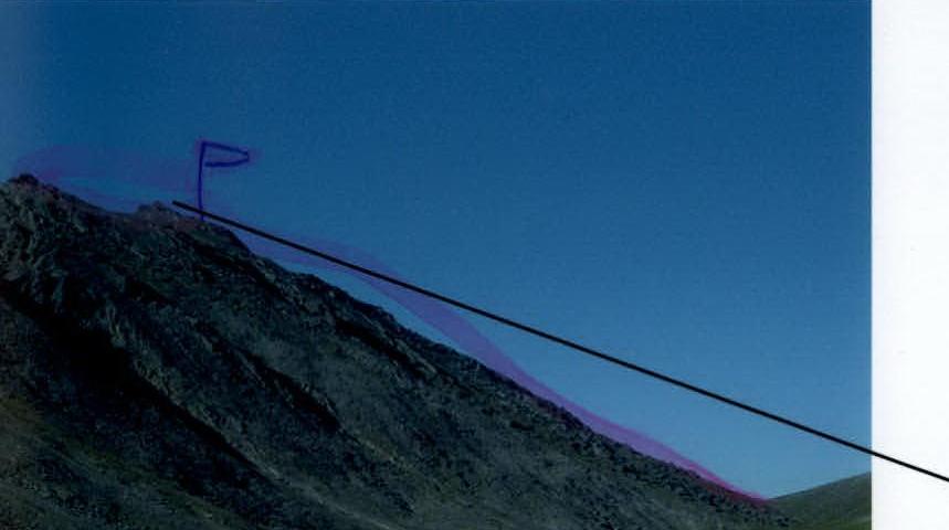
Section R5–R6. False summit and pre-summit ridge
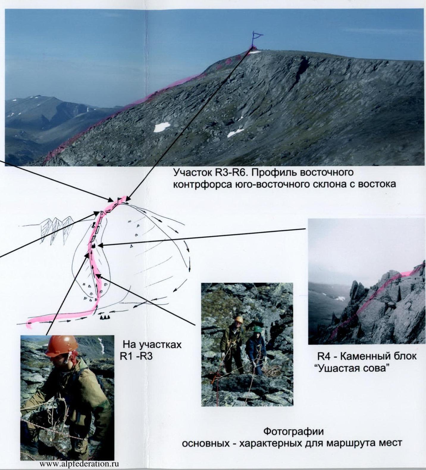 Section R3–R6. Profile of the eastern spurs of the southeast slope from the east

On sections R1–R3
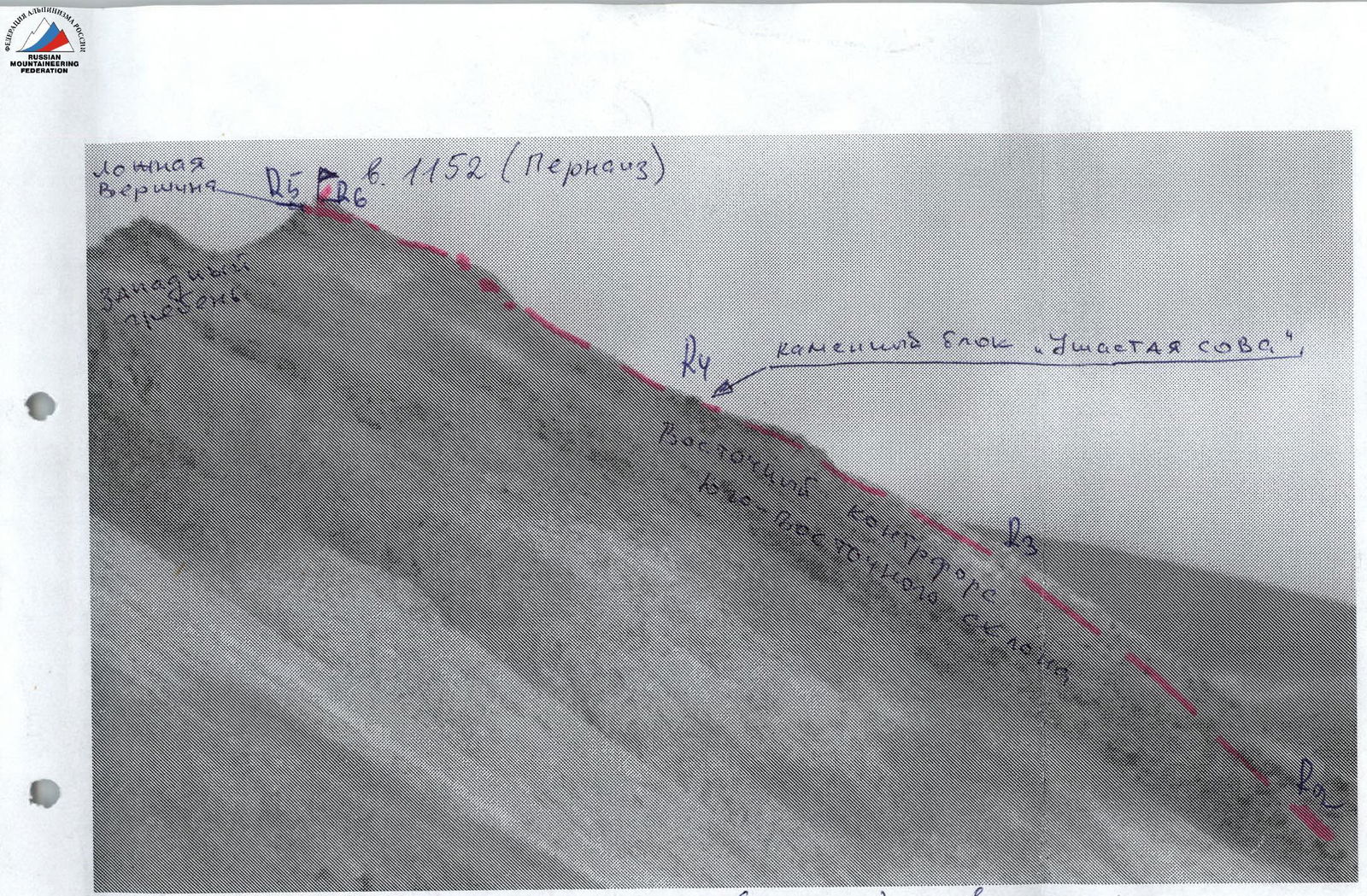
R4 – "Eared Owl" rock block
Description of the Peak
Peak 1152 (Pernayz) is located in the southeastern part of the Parnokaiz mountain massif of the Narod-Ityinsky Ridge in the Subpolar Urals.
Peak 1152 (Pernayz) is situated between an unnamed stream and the Pernavozh stream, which flow into the Bolshaya Lemva River. It is a heavily eroded mountain with rocky and scree-covered, heavily destroyed ridges, rocky spurs leading to the ridges, and a rocky tower at the highest point. Peak 1152 (Pernayz) is the southeastern peak of the Parnokaiz mountain massif.
The peak is not named on the map. Pernayz is the local name for the peak, associated with the Pernavozh stream that flows around it from the north and northwest. The peak is called Pernayz by reindeer herders – Ob Komi people from the village of Saranpaul, who graze their herds in the Bolshaya Lemva River valley during the summer.
Description of the Route
Approach: from the bivouac in the upper reaches of the Bolshaya Lemva River (conserved geologists' base "Lemva": 3 cabins + bathhouse) descend down the Bolshaya Lemva River valley to the Pernavozh stream, which flows into the Bolshaya Lemva on the right.
Technical part of the route: follow the left (right as you move) bank of the Pernavozh stream upwards along a weakly defined geological trail leading to the pass through the Main Watershed Ridge of the Subpolar Urals. On the left, a characteristic landmark – the "Tower" rock massif. Further on – a characteristic landmark – the "Three Stones" rock outcrop. After the "Three Stones" rock outcrop, turn left from the geological trail, cross the Pernavozh stream, and approach the rocky-scree lap of the eastern spurs of the southeast slope. At the base of the lap, it's convenient to form rope teams. Then ascend along the large-block scree to the rocky ridge of the spur. Move along the rocky, heavily destroyed ridge simultaneously, on a shortened rope. By anchoring the rope to rocky outcrops of the ridge and large stone blocks, move until you reach the characteristic stone block – "Eared Owl". (At the "Eared Owl" rock block – a control cairn.) After "Eared Owl", the ridge narrows, the rocks become steeper and smoother. Along a series of inclined shelves and slabs, adhering to the ridge, with alternating belays, and on some sections – with fixed ropes, reach the pre-summit. (The pre-summit is a large rocky sentinel on the summit ridge.) It's climbed "head-on". Then, along a not very steep rocky ridge – exit to the summit 1152 (Pernayz).
Descent route: it's recommended to descend via the more safe route, category 1B, along the eastern ridge.
Required equipment (for a team of 6 people, NP-2):
- main rope – 3×40 pcs;
- rock hammer – 2 pcs;
- carabiners – 10 pcs;
- rock hooks – 5 pcs;
- stoppers – 5 pcs;
- quickdraws – 5 pcs;
- anchor loops – 5 pcs;
- stove – 1 pc;
- pot – 1 pc.
UIAA Sign Scheme
Peak: 1152 (Pernayz) Route: via the eastern spurs of the southeast slope
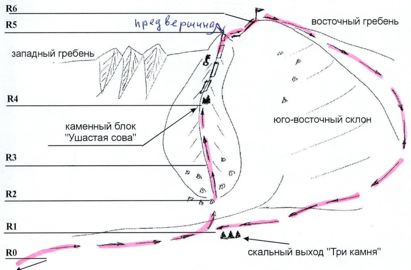
R0 – Base camp – conserved geologists' base "Lemva"
R0–R1 – Approach to the start of the route – "Three Stones" rock outcrop. Weakly defined geological trail. Mountain tundra, scree.
- Section length – 1500 m
- Section steepness – 15°
- Technical difficulty level – non-categorized
Landmark – "Three Stones" rock outcrop on the right. Movement is simultaneous.
R1–R2 – Ascent along the scree slope to the base of the spur. Character of the section – scree, large-block and medium-block slope. Simple rocks.
- Section length – 200 m
- Section steepness – 35°
- Technical difficulty level – non-categorized, 1st cat.
- Movement is simultaneous
R2–R3 – Exit to the ridge of the spur. Character of the section – simple rocks.
- Section length – 100 m
- Section steepness – 45°
- Technical difficulty level – 1+ cat.
- Movement is simultaneous, partially alternating.
R3–R4 – Passage along the ridge to the "Eared Owl" rock block. Character of the section – rocky, heavily destroyed ridge, simple rocks.
- Section length – 400 m
- Section steepness – 35–40°
- Technical difficulty level – 2nd cat.
- Movement is alternating.
R4–R5 – Exit to the pre-summit. Rocky, heavily destroyed ridge. Not very steep but smooth rocky slabs.
- Section length – 200 m
- Steepness – 35–45°
- Technical difficulty level – 1+, 2nd cat.
- Movement is alternating.
R5–R6 – Passage along the pre-summit ridge and exit to the summit. Character of the section – rocky, heavily destroyed ridge. Simple rocks.
- Section length – 100 m
- Section steepness – 15–20°
- Technical difficulty level – 1+, 2nd cat.
- Movement is simultaneous.
R6 – summit 1152 (Pernayz)
R6–R0 – descent along the eastern ridge.
Schematic map of the peaks of the Parnokaiz mountain massif (out of scale)
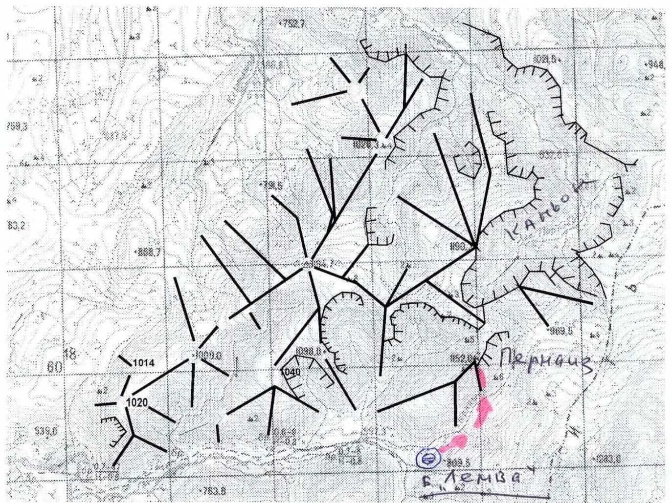 Peak: 1152 (Pernayz). Route: via the central spurs of the southeast slope. 2A cat. (rocky).
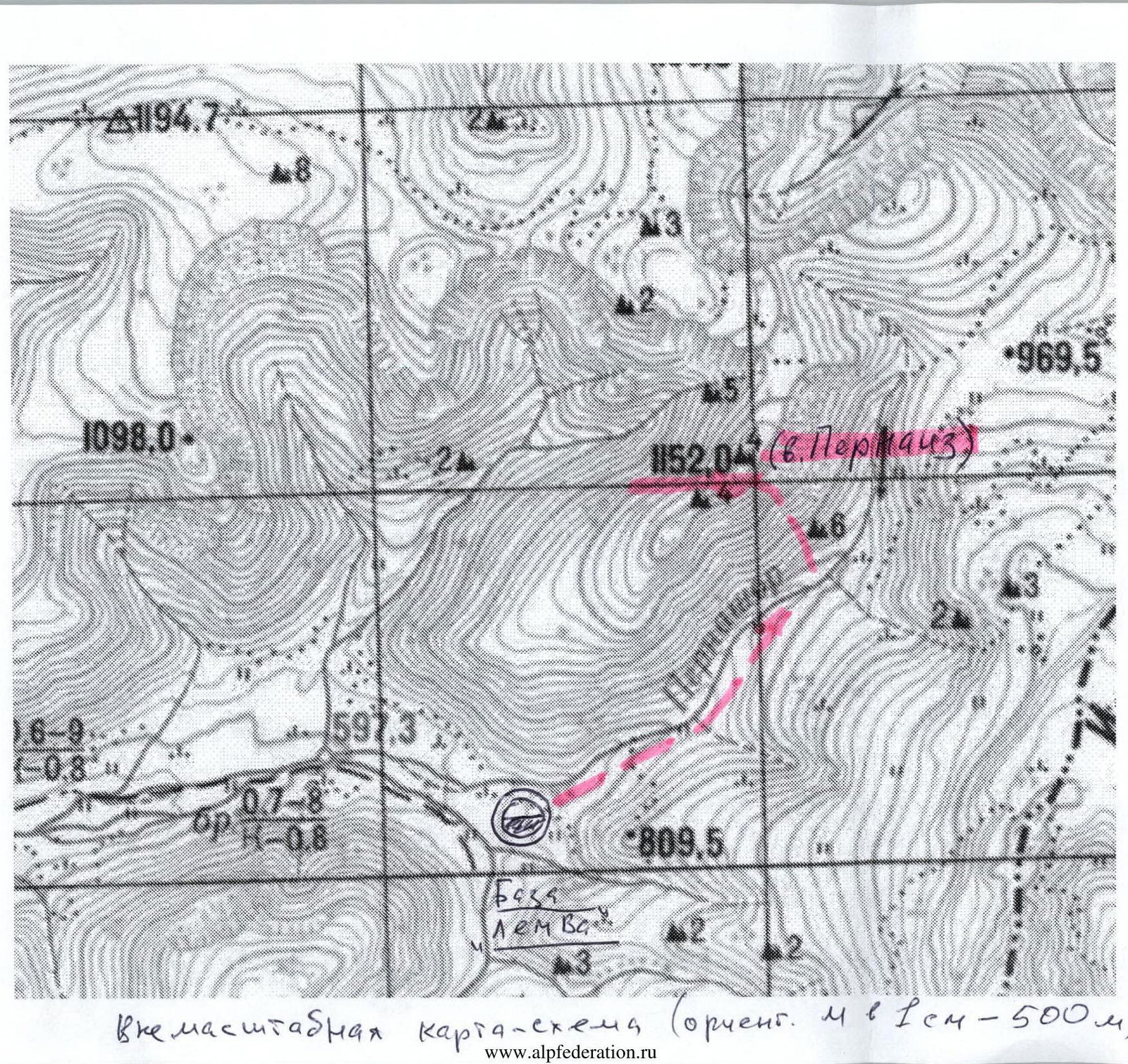
Out-of-scale schematic map (approx. scale: 1 cm – 500 m).
R4 – "Eared Owl" rock block
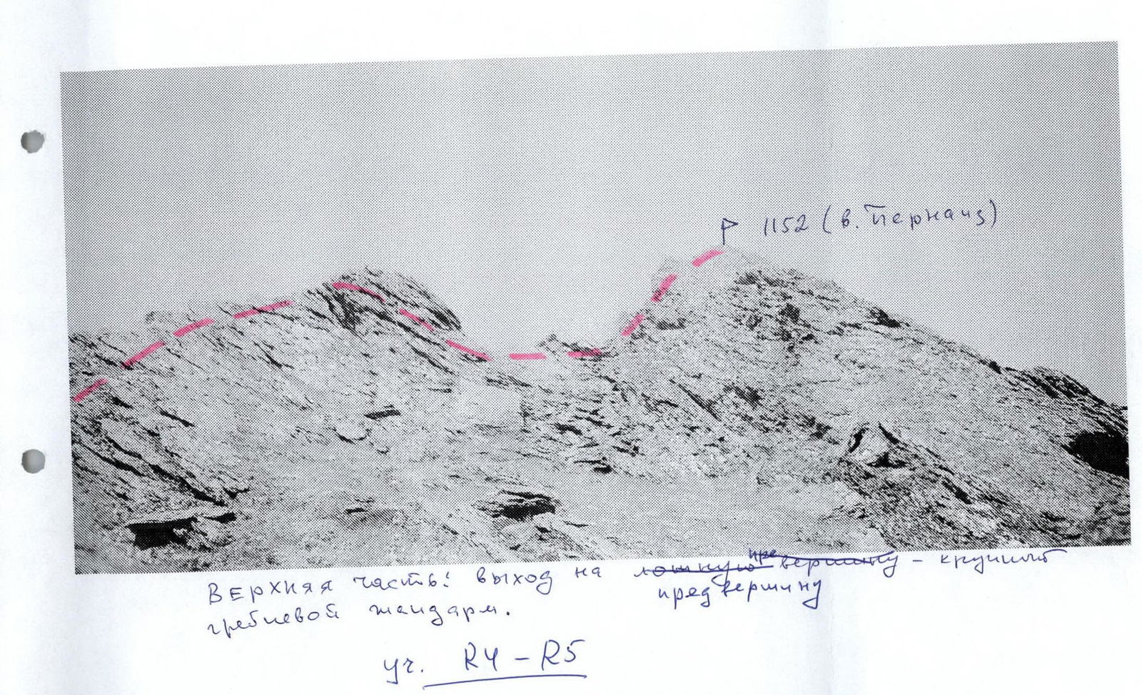
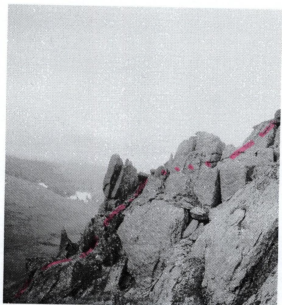
Upper part: exit to the false summit – a large pre-summit sentinel. Section R4–R5.
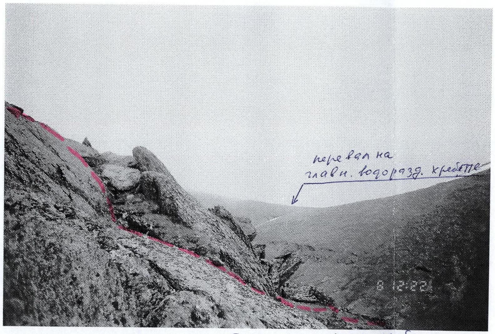
Characteristic sections of the rocky ridge of the eastern spurs on section R3–R4.