Region — Subpolar Urals. Ridge — Narod-Ityinsky Ridge (kряж). Gorge — Valley of the Bolshaya Lemva River. Mountain massif — Parnokaiz. Section number according to KMGV-2001 — No. 8. "Other mountain systems, massifs". Name of the summit — 1152 (Pernayiz). Height — 1152 m. Route name — via the eastern ridge. First ascent. Proposed complexity category for inclusion in the KMGV of the Climbing Federation of Russia — 1B category (rocky). Note: The Climbing Federation of the Komi Republic requests the classification committee of the FAR to credit the group of pioneers with an ascent of 2A category.
Height difference — 580 m. Route length — 3000 m. Average steepness of the main (technical part) of the route — 35°. Average steepness of the entire route — 20°. Sections of 3, 4, 5, and higher complexity categories — none. No hooks were left on the route.
Time spent by the team on the ascent:
- Approach to the base camp (conserved geologists' base "Lemva") from the miners' settlement Pachvoz — 2 days.
Ascent from the base camp — 4 hours. Leader: Zhuravlev Sergey Vasilyevich (CMS, instructor 2nd category — cert. No. 1124, Syktyvkar).
Participants:
- Gayner P. S. (holder of the "Alpinist of Russia" badge, Syktyvkar)
- Boyko I. A. (holder of the "Alpinist of Russia" badge, Syktyvkar)
- Rasputin A. V. (holder of the "Alpinist of Russia" badge, Syktyvkar)
- Ignatov E. M. (holder of the "Alpinist of Russia" badge, Syktyvkar)
Coach — Zhuravlev S. V. (CMS, instructor 2nd category — cert. No. 1124, Syktyvkar). Senior coach — Fomenko Felix Nikolaevich (CMS, instructor 1st category — cert. No. 7, Ukhta).
Departure for the route — 8:00, August 11, 2005. Reaching the summit — 12:15, August 11, 2005. Return to the base camp — 14:00, August 11, 2005. Climbing event: Monitoring expedition of the Climbing Federation of the Komi Republic "Lemva-2005".
Organizers of the expedition:
- Climbing Federation of the Komi Republic
- Non-profit partnership "Club of Northern Travels - 'Sauk-Pai'"
- Club of tourists and climbers of Ukhta.
Climbing Federation of the Komi Republic NP "Club of Northern Travels 'Sauk-Pai'" Club of tourists and climbers of Ukhta
Report on the first ascent
Mountain region: Subpolar Urals Gorge: valley of the Bolshaya Lemva River Ridge: Narod-Ityinsky Ridge (kряж) Mountain massif: Parnokaiz Summit: 1152 (Pernayiz) Route: via the eastern ridge Proposed complexity category for inclusion in the KMGV of the Climbing Federation of Russia: 1B category (rocky). (Credit the group that made the first ascent as a 2A category ascent.) Leader, commander of the training group NP-1,2: Zhuravlev S. V. Date of ascent: August 11, 2005. Climbing event: Monitoring expedition of the Climbing Federation of the Komi Republic "Lemva-2005".
Senior coach — Fomenko F. N. (CMS, instructor 1st category — cert. No. 7, Ukhta).
Deputy for safety ( начспас ) of the Climbing Federation of the Komi Republic: Zhuravlev S. V. (CMS, instructor 2nd category — cert. No. 1124, badge — No. 6190, Syktyvkar).
Report prepared by: expedition leader: Zhuravlev Sergey Vasilyevich.
Address: 167000, Syktyvkar, Internatsionalnaya st., 97, apt. 12.
Contacts:
- Phone: (8212) 24-24-91 (home)
- E-mail: Zhur58@Rambler.Ru
Syktyvkar,
2006
Bug 4a. 1152 (Pernayiz) from the south.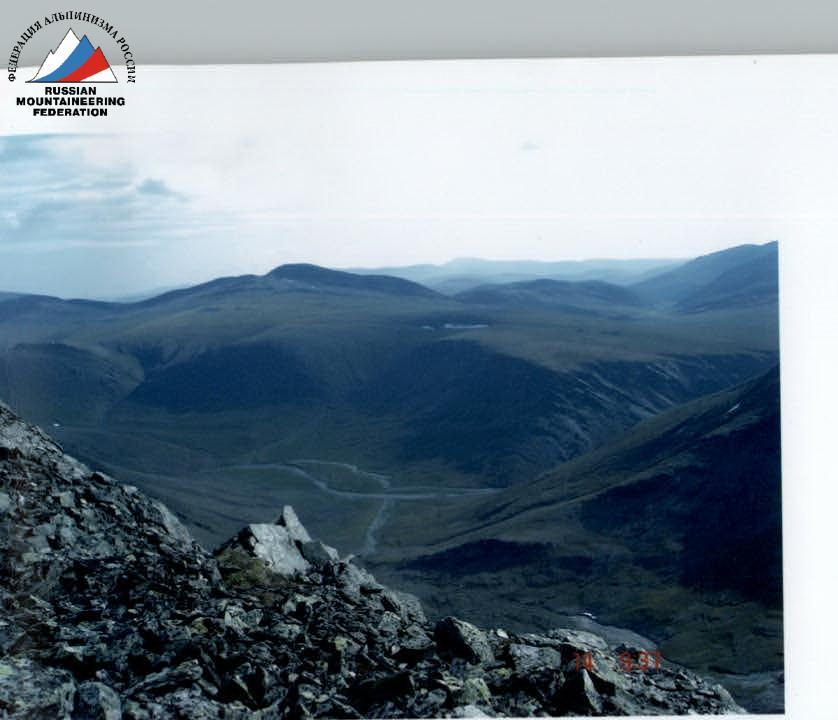
View from the summit 1154 (Pernayiz) to the southwest.
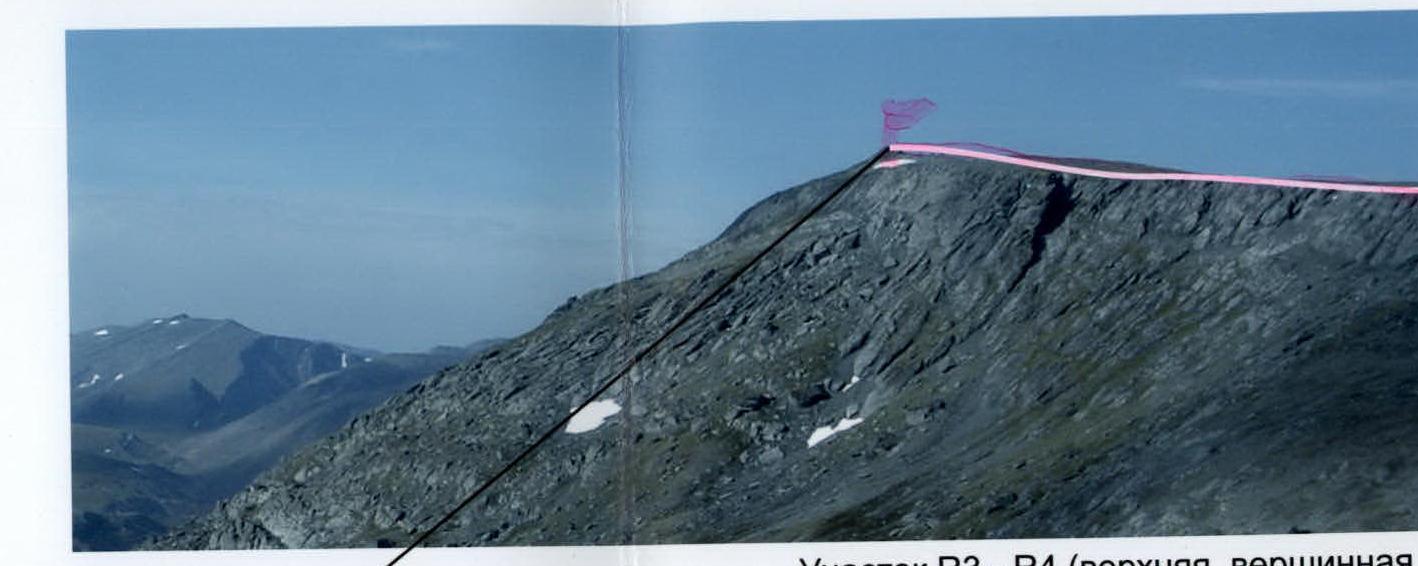
Section R3–R4 (upper, summit part of the rocky-scree eastern ridge).
Section R3–R4 (upper, pre-summit part of the rocky-scree eastern ridge).
Photographs of the main — characteristic places of the route.
Description of the summit
The summit 1152 (Pernayiz) is located in the southeastern part of the Parnokaiz mountain massif of the Narod-Ityinsky Ridge in the Subpolar Urals. The summit 1152 (Pernayiz) is situated between the unnamed stream and the Pernashor stream, which flow into the Bolshaya Lemva River. It is a heavily destroyed mountain with a rocky ridge and a rocky tower at the highest point. It is the southeastern summit of the Parnokaiz mountain massif.
The name of the summit is not indicated on the map. Pernayiz is the local name of the summit, associated with the Pernashor stream, which flows around the summit from the north and northwest. The summit is called Pernayiz by reindeer herders — Ob Komi people from the village of Saranpaul, who occasionally graze their herds in the valley of the Bolshaya Lemva River during the summer.
Description of the route
Approach: from the bivouac in the upper reaches of the Bolshaya Lemva River (conserved geologists' base "Lemva": 3 barracks + bathhouse) go down the valley of the river to the Pernavozh stream, which flows into the Bolshaya Lemva on the right.
Technical part of the route: Along the left (right as you move) bank of the Pernavozh stream, ascend along a weakly expressed geological trail leading to the pass through the main watershed ridge of the Subpolar Urals. To the left, along the Pernashor stream, a characteristic landmark is the rocky massif "Tower". Further — a characteristic landmark — the rocky outcrop "Three stones". Then, without reaching the pass, begin traversing the southeastern slope with a constant slight ascent to exit onto the ridge — the northeastern edge of the canyon of the Left Parnokayu River. Further movement along the ridge to the saddle — the eastern exit to the pre-summit plateau of the Parnoksky gonny massif. From the saddle, to the left (as you move) along the heavily destroyed rocky-scree ridge, ascend under the rocky tower of the summit 1152 (Pernayiz). Then, along simple rocks, exit to the summit.
Descent path: Recommended descent via the ascent route. Required equipment: main rope 3×40 pcs, rock hammer — 2 pcs, carabiners — 10 pcs, rock hooks — 5 pcs, закладные элементы (stopper) — 5 pcs, оттяжки — 5 pcs, петли станционные — 5 pcs, primus stove — 1 pc, pot — 1 pc.
Time taken for the ascent by the training group NP-2 of six people: 4–6 hours.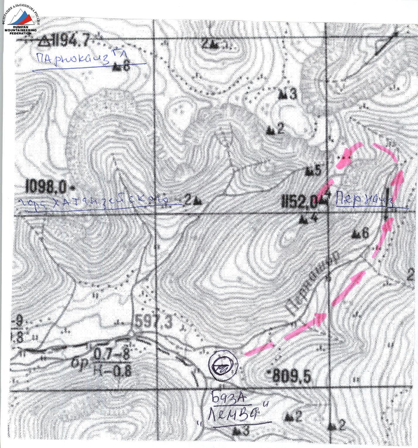
Scheme in UIAA signs
Summit: 1152 (Pernayiz) Route: via the eastern ridge 1B category (rocky)
Mt. 1190 (Parnokaiz East)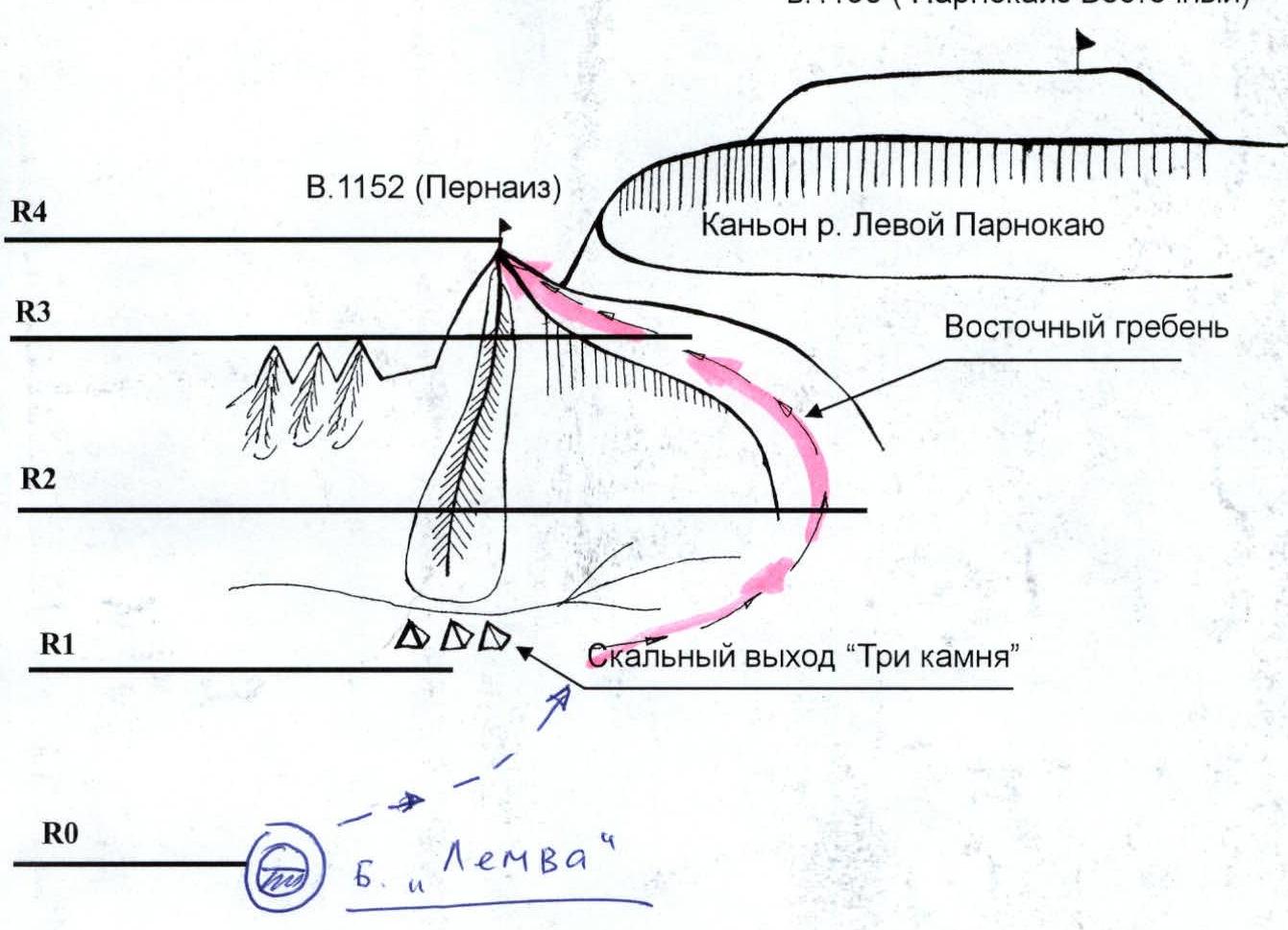
R0 — Base camp — conserved geologists' base "Lemva".
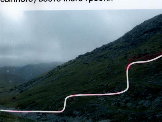
R0–R1 — Approach to the start of the route — "Three stones". Weakly expressed geological trail. Mountain tundra, scree. Length of section — 1500 m, steepness — 15°, level of technical complexity is non-categorized. Landmark — rocky outcrop "Three stones" to the right.
R1–R2 — Ascent along the scree slope and traverse of the scree slope of the Main Watershed Ridge. Scree, large-block and medium-block slope. Simple rocks. Length of section — 2000 m, steepness — 25°. Level of complexity is non-categorized, 1st category. Simultaneous movement.
R2–R3 — Exit to the rocky edge of the canyon of the Left Parnokayu River. Simple rocks. Length of section — 150 m, steepness — 45°, level of technical complexity — 1st category. Simultaneous movement.
R3–R4 — Exit to the ridge, passage along the ridge to the summit. Simple rocks. Length of section — 300 m, steepness — 15°, level of technical complexity — 1st category. Alternating movement.
R4 — summit 1152 (Pernayiz).
R4–R0 — descent via the ascent route — along the eastern ridge.