The peaks 1192 (Pendirmapэ South), Pendirmapэ (1221). Route: Traverse of peaks 1192 (Pendirmapэ South) — Pendirmapэ (1221) (S–N). Cat. — 1B (Combined).
Leader: Gennadiy Vladimirovich Kosyrev. Northern part of Polar Urals (Transpolar Urals), Maly Paipudinsky mountain range.
Section in KMGV — 8.3. E-mail — ZHUR58@RAMBLER.RU
Report
On the first ascent of the mountaineering route: "Traverse of peaks 1192 (Pendirmapэ South) — Pendirmapэ (1221) from south to north 1B cat. sl. (Combined)".
At the year-round alpine event
- Cup of NP "Club of Northern Travels "Sauk-Pai" (Class "First Ascents")
- 2014 year
Region: Ural Federal District of the Russian Federation (UFD), Yamalo-Nenets Autonomous Okrug of Tyumen Oblast. Hot country: Northern part of Polar Urals (Transpolar Urals). Valley: valley of the Malaya Paipudyna River. Ridge: Maly Paipudinsky. Peaks:
- 1192 (Pendirmapэ South)
- Pendirmapэ (1221). Route: Traverse of peaks 1192 (Pendirmapэ South) — Pendirmapэ (1221) (S–N)
Prepared by:
- Kosyrev G. V.
- Zhuravlev S. V.
July 2014
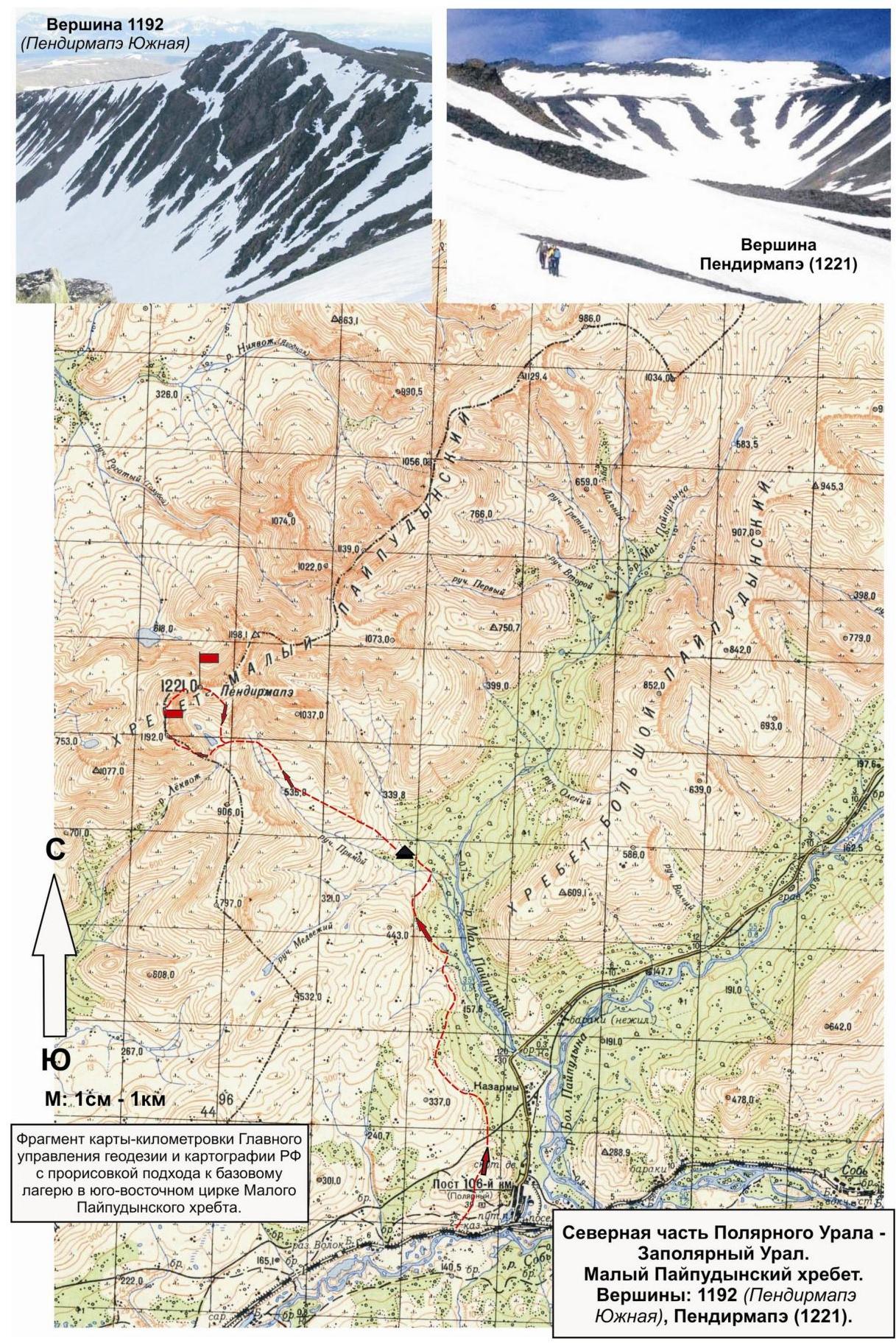
Northern part of Polar Urals Transpolar Urals. Maly Paipudinsky ridge. Peaks:
- 1192 (Pendirmapэ South)
- Pendirmapэ (1221)
Lekts 1196 (Pendirmapэ South) R3 Lekts 1196 (Pendirmapэ (1221) R5 Lekts 1196 (Pendirmapэ (1221) R6 Lekts 1196 (Pendirmapэ (1221) R7 Lekts 1196 (Pendirmapэ (1221) R8 Lekts 1196 (Pendirmapэ (1221) "Grebenka" R9 Lekts 1196 (Pendirmapэ (1221) R10 Lekts 1196 (Pendirmapэ South) R11 Lekts 1196 (Pendirmapэ South) R12 Lekts 1196 (Pendirmapэ (1221)).
Approximately: 1B cat. sl. (Combined). Technical photo of the route. July 2014.
Passport
- Section number according to KMGV — 2010 year — 8.3.
Northern part of Polar Urals (Transpolar Urals), Maly Paipudinsky ridge.
- Name of the peak: 1192 (Pendirmapэ South), Pendirmapэ (1221)
- Height: 1192–1221 m.
- Route: Traverse of peaks 1192 (Pendirmapэ South) — Pendirmapэ (1221) (S–N)
- Category of complexity: 1B
- Character of the route — combined.
- Height difference of the route: 670 m
- Length of the route: 4900 m
- Length of sections of the highest cat. sl.:
1 к. с. — 5 sections — 4750 m, 2 к. с. — 1 section — 150 m, 3 к. с. — 0 sections, 0 meters, 4 к. с. — 0 sections — 0 m, 5 к. с. — 0 sections — 0 m, 6 к. с. — 0 sections — 0 m.
- Average steepness: –30 degrees.
- Used pitons:
Used total on the route:
- rock pitons — 0 pcs
- закладок — 0 pcs
- Шлямбурных стационарных — 0
- ITO — 0
- Шлямбурных съёмных — 0.
Left "piton" on the route: total — 0 pcs; including Шлямбурных — 0.
- Exit to the route — 6:00, August 1, 2014.
Exit to the summit (Pendirmapэ) — 19:00, August 1, 2014. Return to BL — 21:00, August 1, 2014.
- Team's walking hours: — 15 h.
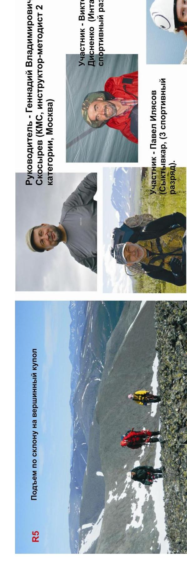
- Leader: G. V. Kosyrev (CMS, instructor-methodologist 2 categories, Moscow).
Participants:
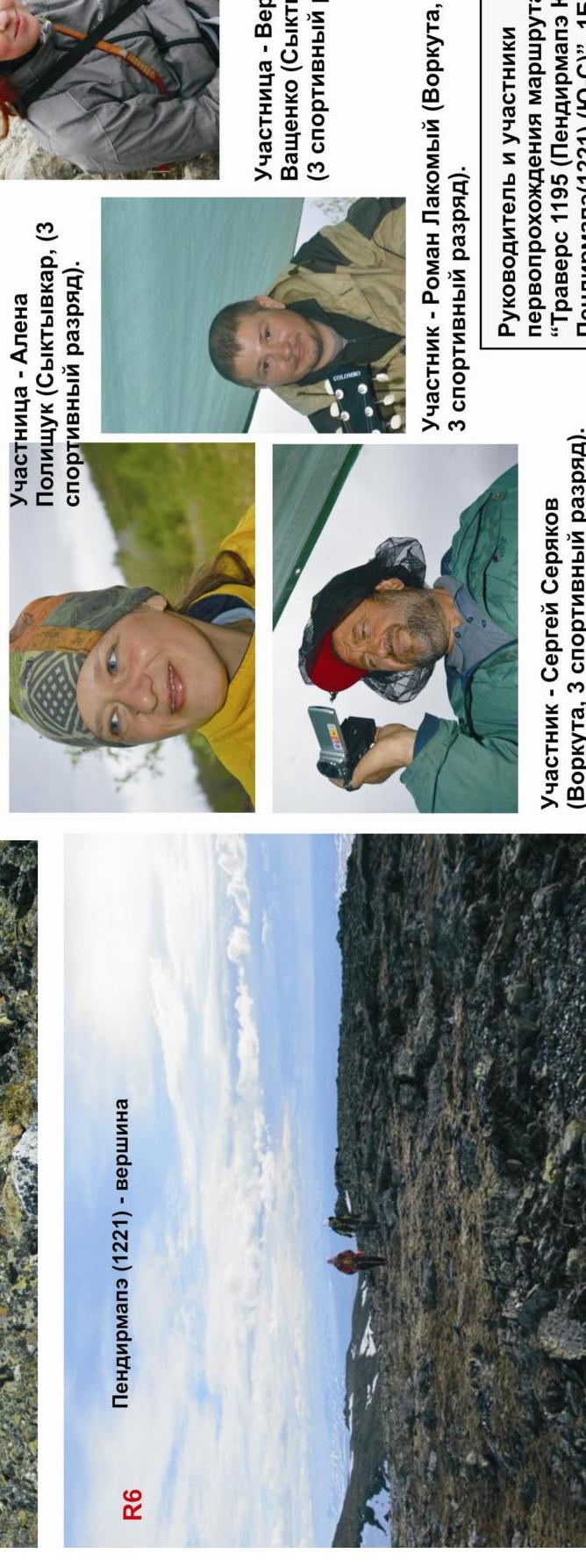
- V. Disnenko (Inta, 3rd sp. разряд)
- S. Seryakov (Vorkuta, 3rd sp. разряд)
- A. Polishchuk (Syktyvkar, 3rd sp. разряд)
- V. Vashchenko (Syktyvkar, 3rd sp. разряд)
- R. Lakomoy (Vorkuta, б/р)
- P. Ilyasov (Syktyvkar, б/р)
- Coach: Zhuravlev Sergey Vasilievich, title — CMS, instructor-methodologist 1 category.
Description of the peak
The peaks 1192 (Pendirmapэ South) and Pendirmapэ are the peaks of the southeastern cirque of the Maly Paipudinsky ridge, located in the main watershed ridge of the northern part of the Polar Urals (Transpolar Urals), on the border of Europe and Asia, the Komi Republic (North-Western Federal District of the Russian Federation) and the Yamalo-Nenets Autonomous Okrug (YNAO) of Tyumen Oblast (Ural Federal District of the Russian Federation).
Peak 1192 (Pendirmapэ South):
- Pronounced mountain-thousander, the southernmost thousander of the Maly Paipudinsky ridge.
- Height — 1192 m above sea level, official, plotted on the map-kilometer of the General Staff of the Russian Federation.
- Does not have an official name, used for identification of the peak in the massif of Pendirmapэ.
Peak Pendirmapэ:
- The highest mountain of the Maly Paipudinsky ridge.
- Height — 1221 m above sea level.
- The name is official, known since the XVIII century, plotted on the maps-kilometer of the General Staff of the Russian Federation.
- Translated from the Nenets language means "Mountain that attracts heavenly thunder, fire (thunder, lightning)".
- One of the most popular peaks of the ridge; ascents are made by tourists along the non-category eastern ridge (descent path).
Description of the route
The route "Traverse of peaks 1192 (Pendirmapэ South) — Pendirmapэ (1221) from south to north" is a typical educational-training combined route of 1B cat. sl., with a full set of rock and snow natural obstacles corresponding to routes of this level. The passage of this route has not only aesthetic, but also educational and sports practical significance, as it allows to work out insurance and self-insurance techniques on rock and snow relief during the ascent. The route is logical, long-lasting, with a technically complex rock key.
Equipment
For the ascent as part of an educational and sports detachment of 6 people (5 participants + instructor) on the route, the following special equipment is required:
personal — standard, including — crampons and ice axe;
public:
- main rope 10 mm — 3×50 m
- rock hammer — 1 pc
- rock pitons — 4 pcs
- ice axe — 1 pc
- закладные элементы — 6 pcs
- оттяжки — 6 pcs
- петли — 10 pcs
Approach
The ascent is made from the "Between the streams Medvezhiy and Pryamoy" site.
Approach to the site:
- From the "110 km" halt (former settlement Polyarný) walk along the dirt road to the destroyed bridge across the Malaya Paipudyna River.
- Then along the right bank of the river rise to the upper reaches of the Malaya Paipudyna River.
- Along the way, quite difficult fording through the Medvezhiy stream and its tributaries.
- After crossing the Medvezhiy stream on the high left bank — convenient places for organizing a bivouac.
It should be taken into account that the "Between the streams Medvezhiy and Pryamoy" bivouac is located in the tundra zone, gas burners are necessary.
-
Telephone communication is not available.
-
Communication by VHF radio stations is problematic.
-
The approach from the "110 km" halt to the bivouac takes 3–4 hours.
-
The approach to the start of the route from the "Between the streams Medvezhiy and Pryamoy" bivouac takes one and a half to two hours.
Technical part
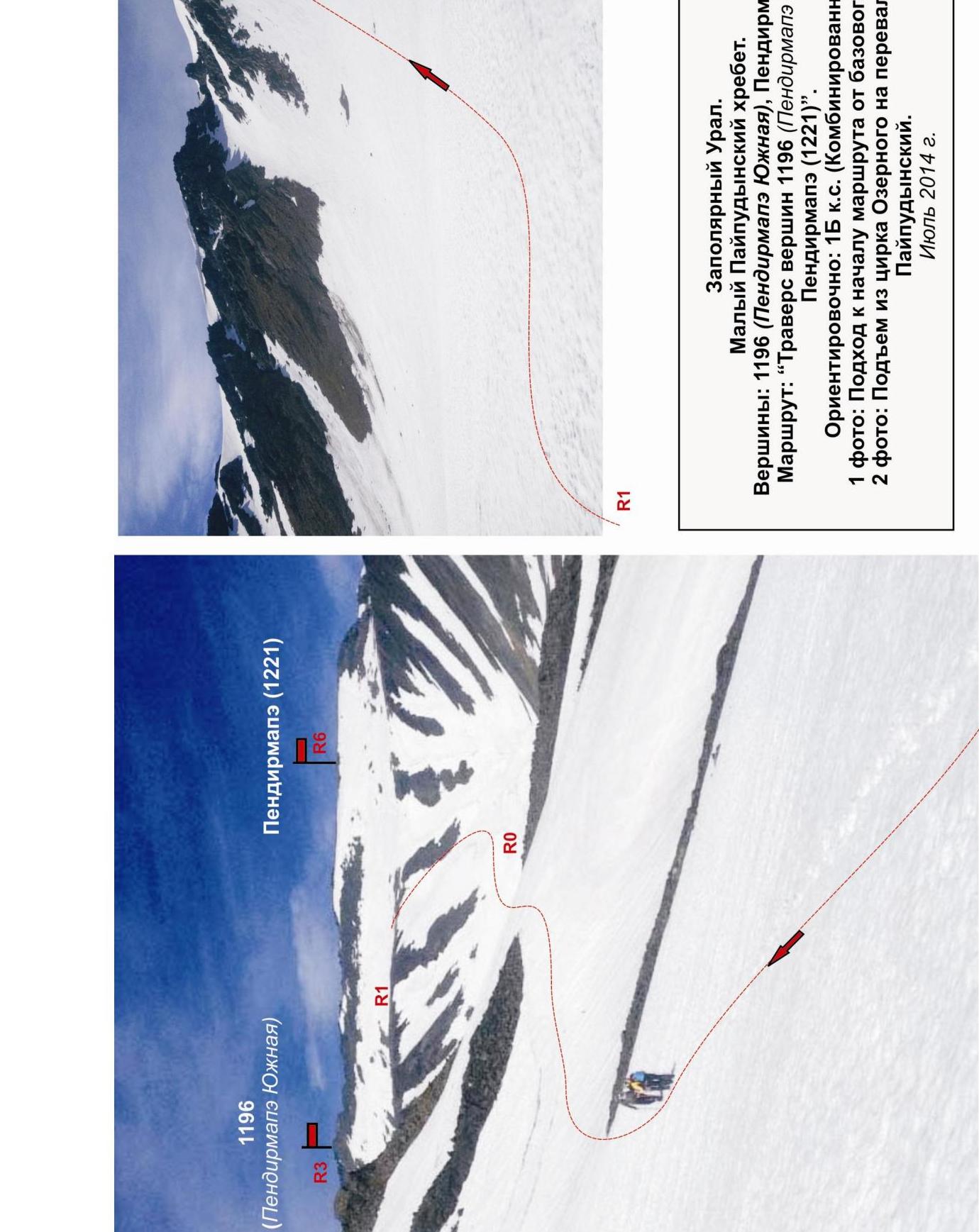
The start of the route is the entrance to the couloir leading to the Ozerny cirque of the southeastern cirque of the Maly Paipudinsky ridge. Climb into the cirque along the snowy couloir. The use of bumps depends on the density of the snow.
The cirque is named Ozerny because of the presence of two kar cirques, from which the Pryamoy stream originates. Even in summer, the lakes may be covered with ice. Exit to the ice mirror of the lakes in summer is not recommended — potential danger!
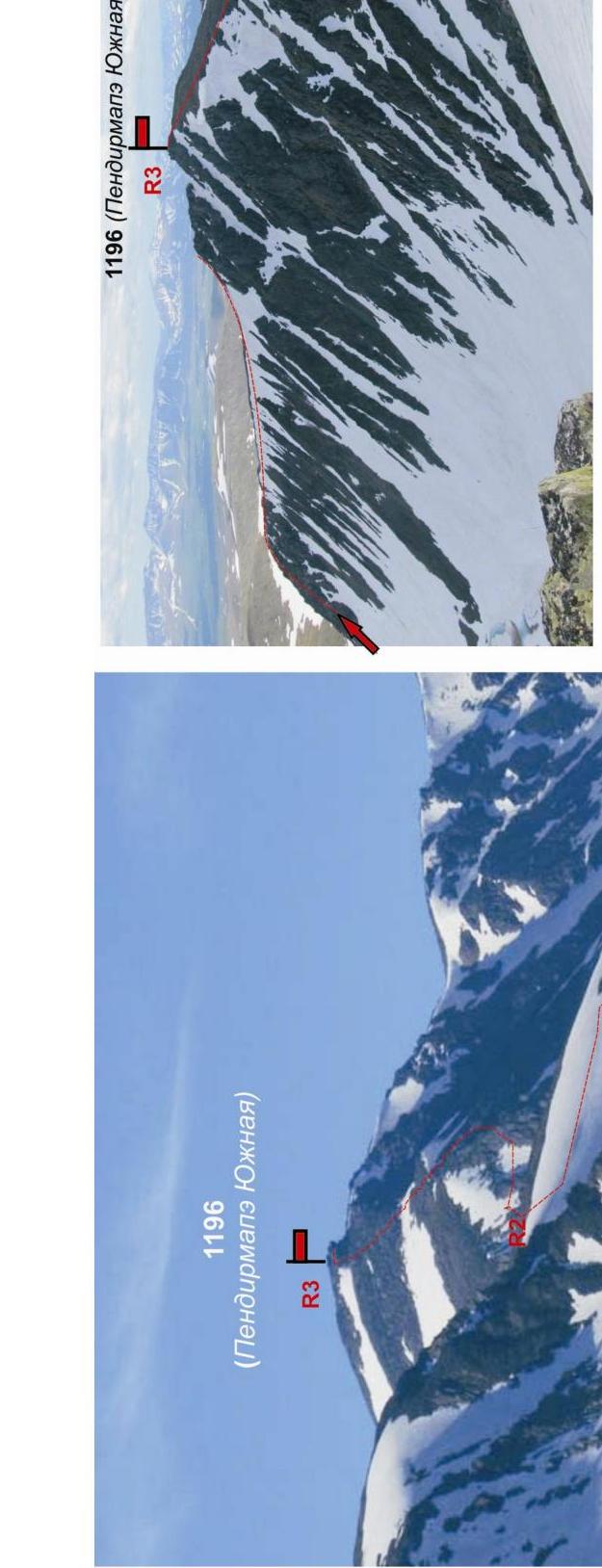
After rounding the lakes (on the left along the way) it is necessary to organize связки. Then climb along the snowy couloir to the Yuzhny Paipudinsky pass, located in the main watershed ridge and separating the valleys of the Pryamoy stream (tributary of the Malaya Paipudyna River) and the Lekvozh stream (tributary of the Elets River).
From the pass along the scree and snow-covered slope rise to the peak 1192 m (Pendirmapэ South). The peak 1192 m (Pendirmapэ South) is dome-shaped, pronounced.
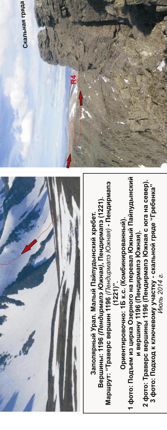
Then descend from it and walk along the wide plateau, sharply narrowing to the north, to the rock ridge "Grebenka".
The rock ridge "Grebenka" is the key to the route:
- Complicated climbing on rocks
- Subjective stone danger, but the rocks are uncomfortable, tile-like slates
The ridge can be passed:
- Traverse to the right, along the line of contact between rocks and snow-covered slope, organizing piton insurance — possible only in the absence of freshly fallen snow due to the steep and avalanche-prone slope
- Movement along the ridge with overcoming "Grebenka" жандармов "in the forehead" — safer both from the point of view of stone danger and from the point of view of avalanche danger
After passing the key — climb along the snowy slope under the summit snow and scree dome. Then along the snow and scree — exit to the summit.
The peak Pendirmapэ (1221 m):
- Plateau-shaped
- Weakly expressed
- Cairn on the junction of the eastern ridge
Descent from the summit.
The descent from the summit is carried out first along the eastern ridge, then along the snowy couloirs of the southern slope of the eastern ridge into the Ozerny cirque. Then return to the bivouac along the ascent route:
- through the snowy couloir exit from the Ozerny cirque,
- then along the valley of the Pryamoy stream.
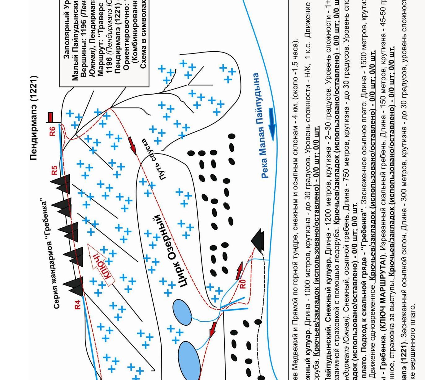
Approach: from the base camp between the streams Medvezhiy and Pryamoy along the mountain tundra, snowy and scree slopes — 4 km (about 1.5 hours).
Section R0–R1 — climb into the Ozerny cirque. Snowy couloir. Length — 1000 m, steepness — up to 30°. Level of complexity — N/C, 1 cat. sl. Movement is simultaneous, self-insurance with the help of an ice axe. Pitons/закладок (used/left) — 0/0 pcs; 0/0 pcs; 0/0 pcs.
Section R1–R2 — climb to the Yuzhny Paipudinsky pass. Snowy couloir. Length — 1200 m, steepness — 2–30°. Level of complexity — 1+, 2+ cat. sl. Simultaneous movement, self-insurance, mutual insurance with the help of an ice axe. Pitons/закладок (used/left) — 0/0 pcs; 0/0 pcs.
Section R2–R3 — climb to the peak 1196 (Pendirmapэ South). Snowy, scree ridge. Length — 750 m, steepness — up to 30°. Level of complexity — 1 cat. sl. Simultaneous movement. Pitons/закладок (used/left) — 0/0 pcs; 0/0 pcs.
Section R3–R4 — passage of the inter-summit plateau. Approach to the rock ridge — "Grebenka". Snow-covered scree plateau. Length — 1500 m, steepness — 10–15°. Level of complexity — non-category. Simultaneous movement. Pitons/закладок (used/left) — 0/0 pcs; 0/0 pcs.
Section R4–R5 — passage of the rock ridge — Grebenka. (Key to the route!). Jagged rock ridge. Length — 150 m, steepness — 45–50°. Level of complexity — 2B, cat. sl. Alternate movement, insurance for ledges. Pitons/закладок (used/left) — 0/0 pcs; 0/0 pcs.
Section R5–R6 — climb to the peak Pendirmapэ (1221). Snow-covered scree slope. Length — 300 m, steepness — up to 30°, level of complexity — N/C, 1, cat. sl. The summit is a rock outcrop on the southeast of the summit plateau.
Northern part of Polar Urals (Transpolar Urals). Maly Paipudinsky ridge.
Peaks: 1192 (Pendirmapэ South) — Pendirmapэ (1221). Route: "Traverse of peaks 1192 (Pendirmapэ South) — Pendirmapэ (1221) from south to north". 1B (combined) (approximately) (table of natural obstacles of the route)
| № section | Length | Steepness | Character of relief | cat. sl. | Number of pitons/закл. |
|---|---|---|---|---|---|
| APPROACH | From the base camp between the streams Medvezhiy and Pryamoy about four kilometers and takes 1.5 hours along the mountain tundra and snowy slopes. | ||||
| R0 — Start of the couloir leading to the Ozerny cirque. | Convenient place for organizing связок | ||||
| R0–R1. Climb along the couloir into the Ozerny cirque | 1000 | up to 30 | Snowy slope, snowy couloir. | H/К,1- | 0 / 0 |
| R1–R2. Climb to the Yuzhny Paipudinsky pass. | 1200 | 20-40 | Snowy couloir | 1,2 | 0 / 0 |
| R2–R3. Climb to the peak 1192 (Pendirmapэ South) | 750 | up to 30 | Snow-covered scree ridge | 1 | 0 / 0 |
| R3 — Peak 1192 (Pendirmapэ South). | Pronounced, dome-shaped. Cairn in the center of the summit. | ||||
| R3–R4. Passage of the inter-summit plateau and approach to the key section of the rock ridge "Grebenka". | 1500 | 45 | Snow-covered scree plateau | H/К,1- | 0 / 0 0 / 0 |
| R4–R5. Passage of the key section of the rock ridge "Grebenka". | 150 | up to 30 | Jagged rock ridge | 2+ | 0 / 0 |
| R5–R6. Climb along the scree slope on | 300 | up to 30 | Snow-covered scree slope | 1 | 0 / 0 |
| the summit plateau | |||||
| :-- | :-- | :-- | :-- | :-- | |
| R6 — Peak Pendirmapэ (1221). | Weakly expressed. Extensive scree plateau. Cairn on the junction of the eastern ridge. | ||||
| DESCENT | Along the eastern ridge, then along the snowy couloirs of the southern slope of the eastern ridge into the Ozerny cirque. Non-category. |
Total
Length of the route — 4900 m. Average steepness — 30°. Character of relief — combined. Technical sections:
- 1 cat. sl. — 5 sections — 4750 m
- 2 cat. sl. — 1 section — 150 m.
Used pitons and закладных: 0/0. Left pitons and закладных: 0/0.
1196 (Pendirmapэ (South))
Pendirmapэ (1221)
R1
Transpolar Urals. Maly Paipudinsky ridge. Peaks: 1196 (Pendirmapэ South), Pendirmapэ (1221). Route: "Traverse of peaks 1196 (Pendirmapэ South) — Pendirmapэ (1221)". Approximately: 1B cat. sl. (Combined).
- 1 photo: Approach to the start of the route from the base camp.
- 2 photo: Climb from the Ozerny cirque to the Yuzhny Paipudinsky pass.
July 2014
Transpolar Urals. Maly Paipudinsky ridge. Peaks:
- 1196 (Pendirmapэ South)
- Pendirmapэ (1221). Route: "Traverse of peaks 1196 (Pendirmapэ South) — Pendirmapэ (1221)".
Approximately: 1B cat. sl. (Combined). 1 photo: Climb from the Ozerny cirque to the Yuzhny Paipudinsky pass and peak 1196 (Pendirmapэ South). 2 photo: Traverse of peak 1196 (Pendirmapэ South) from south to north. 3 photo: Approach to the key section — rock ridge "Grebenka". July 2014.
Leader — Gennadiy Vladimirovich Kosyrev (CMS, instructor-methodologist 2 cat. sl.)
Leader and participants of the first ascent of the route:
- Traverse 1195
- Pendirmapэ South
- Pendirmapэ (1221) (S–N), 1B cat. sl.