Northern part of the Polar Urals —
Transpolar Urals. Maly Pailyudyansky Ridge. Summit — 906 (Oshvozh-Iz).
Passport
- Section number according to KMGV — 2010 — 8.3.
Northern part of the Polar Urals (Transpolar Urals), Maly Pailyudyansky Ridge.
- Name of the summit: 906 (Oshvozh-Iz)
- Height: 906 m
- Route: via the north-eastern ridge
- Category of difficulty: 1B cat. diff.
- Character of the route — combined.
- Height difference of the route: 400 m
- Length of the route: 670 m
- Length of sections of the highest cat. diff.
1 cat. diff. — 3 sections — 600 m, 2 cat. diff. — 2 sections — 70 m, 3 cat. diff. — 0 sections, 0 m, 4 cat. diff. — 0 sections — 0 m, 5 cat. diff. — 0 sections — 0 m, 6 cat. diff. — 0 sections — 0 m.
- Average steepness: — 30°.
- Pitons used:
Total used on the route:
- rock pitons — 2 pcs
- chocks — 4 pcs
- stationary pitons — 0
- IT — 0
- removable pitons — 0.
Left on the route: total — 0 pcs; including stationary pitons — 0.
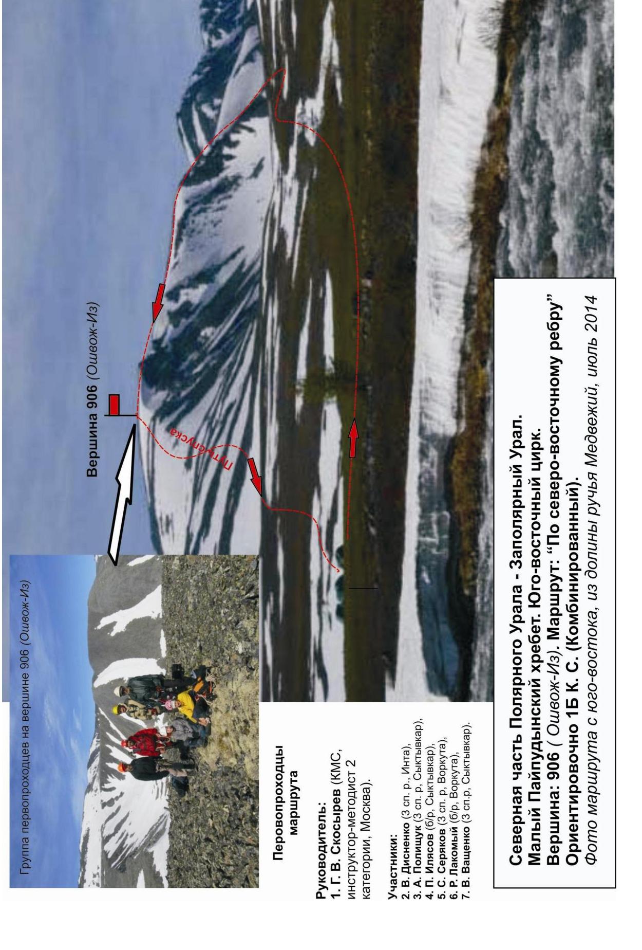
- Departure to the route — 7:00, June 30, 2014.
Reached the summit — 13:00, June 30, 2014. Returned to the base camp — 16:00, June 30, 2014.
- Team's walking hours: — 9 hours.
- Leader: G. V. Skosyrev (Candidate for Master of Sports, instructor-methodologist of the 2nd category, Moscow).
Team members:
- V. Disnenko (Inta, 3rd sports category)
- S. Seryakov (Vorkuta, 3rd sports category)
- A. Polishchuk (Syktyvkar, 3rd sports category)
- V. Vashchenko (Syktyvkar, 3rd sports category)
- R. Lakomoy (Vorkuta, no category)
- P. Ilyasov (Syktyvkar, no category)
- Coach: Zhuravlev Sergey Vasilievich, title — Candidate for Master of Sports, instructor-methodologist of the 1st category.
Northern part of the Polar Urals — Transpolar Urals. Maly Pailyudyansky Ridge. Summit — 906 (Osheozh-it). Route: "Via the north-eastern ridge". Approximately: 1B cat. diff. (combined). Overview photo of the route from the north-east, July 2014.
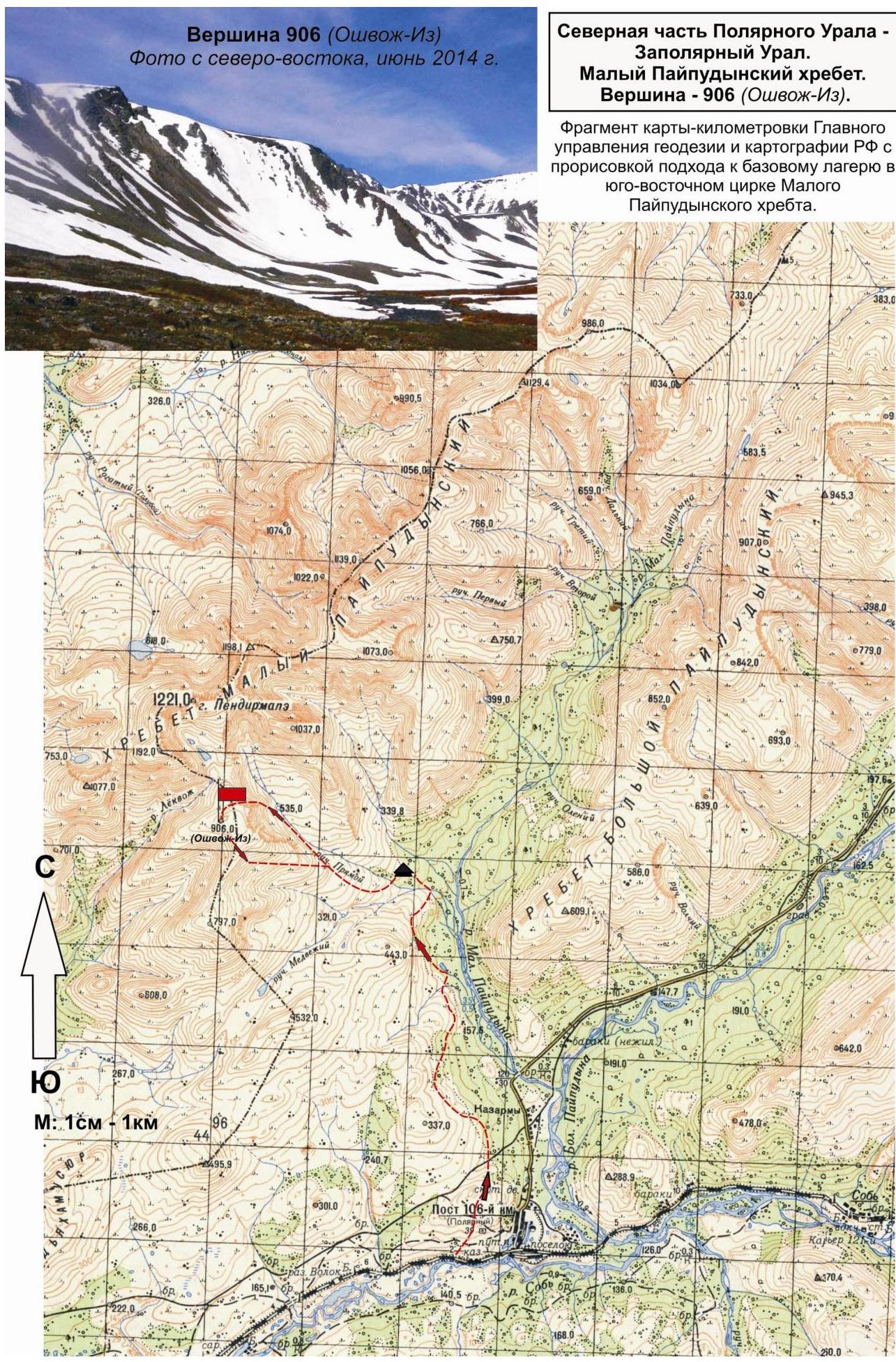
Description of the summit. Summit 906 (Oshvozh-Iz) is one of the summits of the south-eastern cirque of the Maly Pailyudyansky Ridge in the northern part of the Polar Urals (Transpolar Urals), located in the Yamalo-Nenets Autonomous Okrug (YNAO) of the Tyumen Oblast, Ural Federal District, Russian Federation, in the upper reaches of the Medvezhiy stream. Summit 906 (Oshvozh-Iz) is a not very pronounced mountain in the south-eastern spur of the Maly Pailyudyansky Ridge, defined as the left summit of the south-eastern cirque of the Maly Pailyudyansky Ridge. The name is not indicated on the map-kilometer mark of the General Staff of the Russian Federation, recorded from local reindeer herders, translated from the Komi language — "Mountain of the Medvezhiy stream", which corresponds to the toponymy, as the Medvezhiy stream originates on the slopes of the mountain. The name logically serves to identify the summit. The north-eastern ridge is clearly pronounced and easily identifiable.
Description of the route
The route "Via the north-eastern ridge" is a characteristic training and educational combined route of 1B cat. diff., with a full range of rock and snow natural obstacles corresponding to routes of this level.
Passing this route has not only aesthetic but also practical and sports significance, as it allows working out insurance and self-insurance techniques on rock and snow terrain within the ascent.
Equipment
For the ascent as part of a training and sports group of 6 people (5 participants + instructor), the following special equipment is required:
Personal (standard, including):
- crampons
- ice axe
Group:
- main rope 10 mm — 3×50 m
- rock hammer — 1 pc.
- rock pitons — 4 pcs.
- ice axe — 1 pc.
- chock elements — 6 pcs.
- quickdraws — 10 pcs.
- slings — 10 pcs.
Approach
The ascent is made from the "Between Medvezhiy and Pryamoy streams" campsite.
Approach to the campsite:
- From the "110 km" halt (formerly the settlement of Polarny) walk along the dirt road to the destroyed bridge across the Malaya Pailpudyna River.
- Then ascend to the upper reaches of the Malaya Pailpudyna River along its right bank.
- Along the way, there are quite complex fording crossings through the Medvezhiy stream and its tributaries.
- After crossing the Medvezhiy stream on the high left bank, there are convenient places for organizing a bivouac.
Features:
- The "Between Medvezhiy and Pryamoy streams" bivouac is located in the tundra zone — gas burners are necessary.
- No telephone connection.
- Communication via VHF radios is problematic.
Time to approach:
- The approach to the campsite takes 3–4 hours.
- The approach to the start of the route from the "Between Medvezhiy and Pryamoy streams" campsite takes one and a half to two hours.
Movement to the ascent:
- Move along the mountain tundra along the right (orographic) bank of the Pryamoy stream.
- Then — along the snow-covered slopes to the pronounced scree under the ridge.
- On the scree, it is convenient to organize rope teams.
Technical part
The route begins with an approach along the large-block scree to the inner corner leading to the rocky ridge of the rib. Entry into the inner corner on the right (in the direction of travel) slope of the rib. The corner is well pronounced and unambiguous for passage.
Further:
- ascend the destroyed rocky ridge to the rocky shoulder;
- pass along the destroyed, partly scree-covered rocky shoulder;
- exit under the jagged ridge leading under the summit dome.
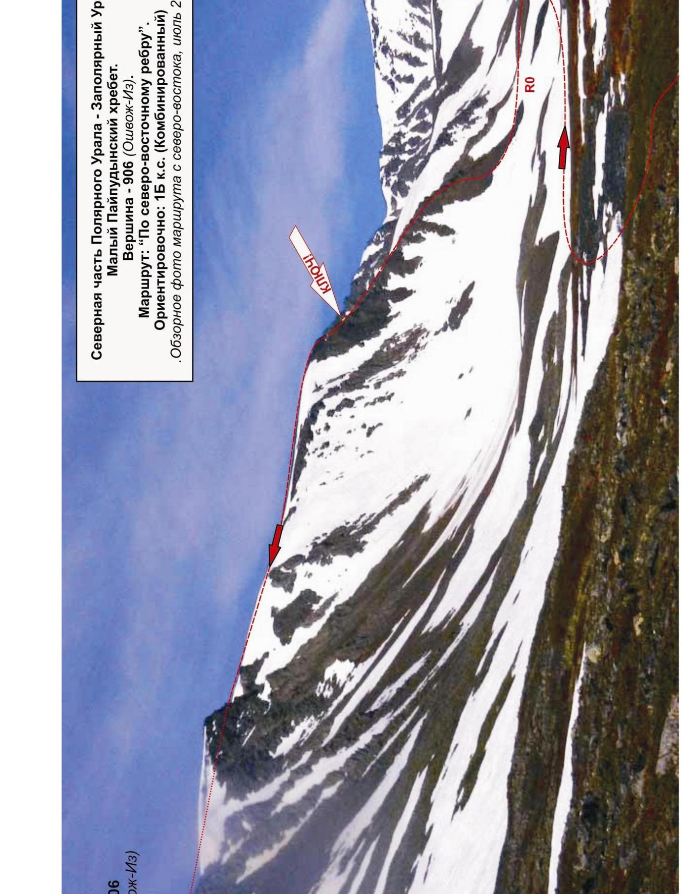
This is the key section of the route.
Key section of the route — jagged rocky ridge.
- Complicated climbing on dense rocks;
- Subjective rockfall danger.
After passing the key section:
- ascent along the snowy slope under the summit snow and snow-scree dome;
- movement along snow and scree to the summit.
Summit — dome-shaped, with a wide the osseous plateau at the top. A cairn in the center of the plateau.
Descent from the summit.
Descent from the summit is made:
- along the south-eastern non-categorized slope to the base camp — "Between Medvezhiy and Pryamoy streams" campsite.
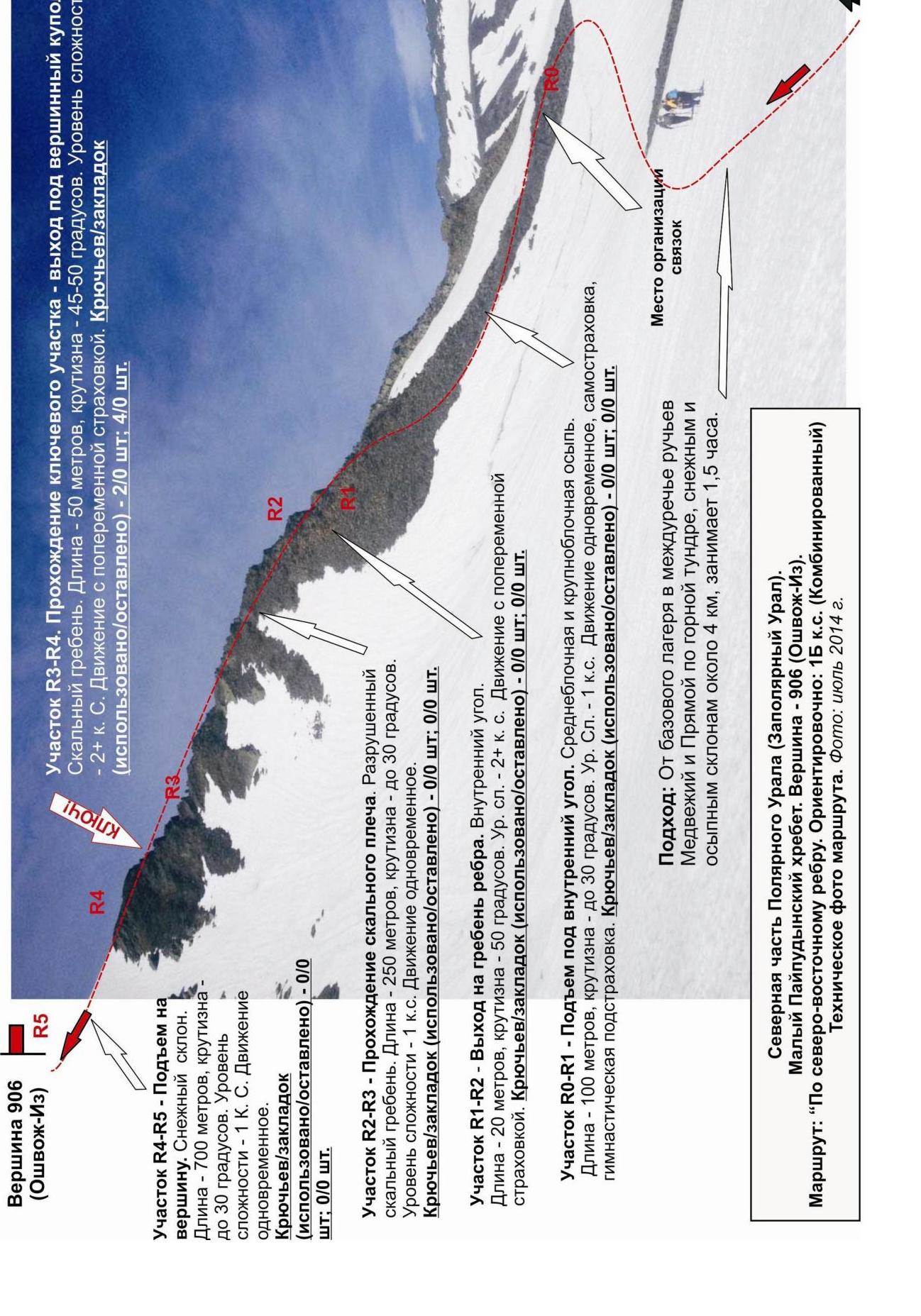
Section R4–R5 — Ascent to the summit. Snowy slope. Length — 700 m, steepness — up to 30°. Level of difficulty — 1 cat. diff. Movement is simultaneous.
Pitons/chocks (used/left) — 0/0 pcs; 0/0 pcs.
Section R2–R3 — Passage of the rocky shoulder. Destroyed rocky ridge. Length — 250 m, steepness — up to 30°. Level of difficulty — 1 cat. diff. Movement is simultaneous.
Pitons/chocks (used/left) — 0/0 pcs; 0/0 pcs.
Section R1–R2 — Exit to the ridge of the rib. Inner corner. Length — 20 m, steepness — 50°. Cat. diff. — 2B. Movement with alternating insurance.
Pitons/chocks (used/left) — 0/0 pcs; 0/0 pcs.
Section R0–R1 — Ascent under the inner corner. Medium-block and large-block scree. Length — 100 m, steepness — up to 30°. Cat. diff. — 1. Movement is simultaneous, with self-insurance and gymnastic insurance.
Pitons/chocks (used/left) — 0/0 pcs; 0/0 pcs.
Approach: From the base camp in the interfluve of the Medvezhiy and Pryamoy streams along the mountain tundra, snowy and scree slopes, about 4 km, taking 1.5 hours.
Northern part of the Polar Urals (Transpolar Urals).
Maly Pailyudyansky Ridge. Summit — 906 (Oshvozh-Iz).
Route: Via the north-eastern ridge. Approximately: 1B cat. diff. (Combined)
Technical photo of the route. Photo: July 2014.
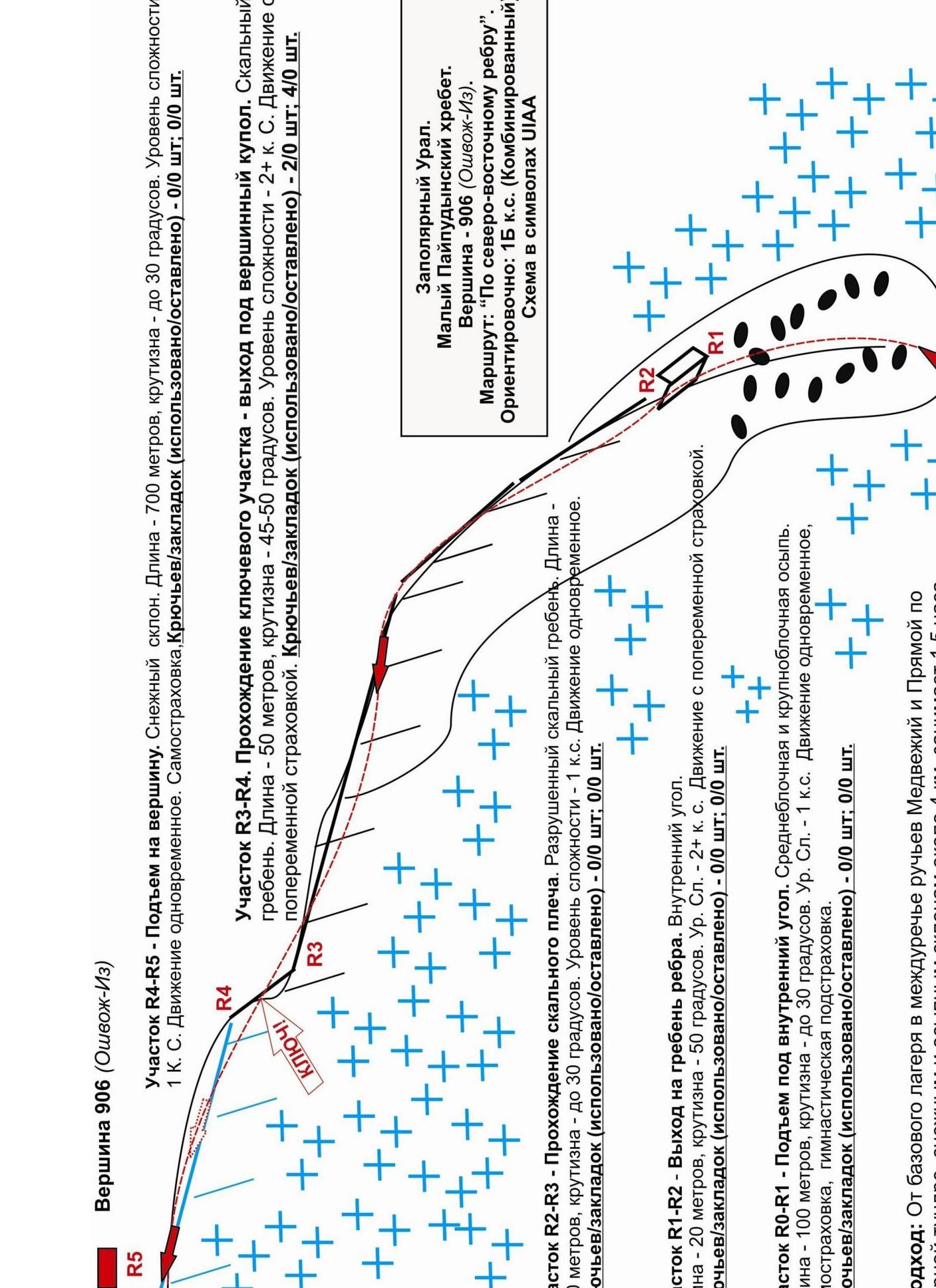
Summit 906 (Oshvozh-Iz)
Section R4–R5
- Ascent to the summit. Snowy slope. Length — 700 m, steepness — up to 30°.
- Level of difficulty — 1 cat. diff.
- Movement is simultaneous.
- Self-insurance.
- Pitons/chocks (used/left) — 0/0 pcs; 0/0 pcs.
Section R3–R4
- Passage of the key section — exit under the summit dome.
- Rocky ridge. Length — 50 m, steepness — 45–50°.
- Level of difficulty — 2+ cat. diff.
- Movement with alternating insurance.
- Pitons/chocks (used/left) — 2/0 pcs; 4/0 pcs.
Section R1–R2
- Exit to the ridge of the rib.
- Inner corner. Length — 20 m, steepness — 50°.
- Level of difficulty — 1 cat. diff.
- Movement is simultaneous.
- Pitons/chocks (used/left) — 0/0 pcs; 0/0 pcs.
Section R1–R2
- Exit to the ridge of the rib.
- Inner corner. Length — 20 m, steepness — 50°.
- Level of difficulty — 1 cat. diff.
- Movement with alternating insurance.
- Pitons/chocks (used/left) — 0/0 pcs; 0/0 pcs.
Section R0–R1
- Ascent under the inner corner.
- Medium-block and large-block scree.
- Length — 1000 m, steepness — up to 30°.
- Level of difficulty — 1 cat. diff.
- Movement is simultaneous, with self-insurance and gymnastic insurance.
- Pitons/chocks (used/left) — 0/0 pcs; 0/0 pcs.
Approach
From the base camp in the interfluve of the Medvezhiy and Pryamoy streams along the mountain tundra, snowy and scree slopes, about 4 km, taking 1.5 hours.
Transpolar Urals.
- Maly Pailyudyansky Ridge.
- Summit — 906 (Oshvozh-Iz).
- Route: "Via the north-eastern ridge".
- Approximately: 1B cat. diff. (combined).
- Scheme in UIAA symbols. Northern part of the Polar Urals (Transpolar Urals). Maly Pailyudyansky Ridge. Summit 906 (Oshvozh-Iz). Route: "Via the north-eastern ridge" 1B (combined) (approximately) (table of natural obstacles of the route)
| Section № | Length | Steepness | Terrain character | Cat. diff. | Number of pitons/chocks |
|---|---|---|---|---|---|
| APPROACH | From the base camp in the interfluve of Medvezhiy and Pryamoy streams about four kilometers and takes 1.5 hours along the mountain tundra and snowy slopes. | ||||
| R0 — Medium-block scree at the base of the rib | Convenient place for organizing rope teams | ||||
| R0–R1 Ascent along large-block scree under the inner corner | 100 | up to 30 | Mountain tundra. Snow. | 1 | 0 / 0 |
| R1–R2 Passage of the inner corner and exit to the rocky ridge of the rib. | 20 | 50 | Inner corner | 2+ | 0 / 0 |
| R2–R3 Passage of the rocky shoulder. | 250 | up to 30 | Destroyed rocky ridge | 1 | 0 / 0 |
| R3–R4 KEY! Passage of the rocky ridge and exit under the summit dome. | 50 | 45 | Jagged rocky ridge | 2+ | 2/0 4/0 |
| R4–R5 Exit to summit 906 (Oshvozh-Iz) | 250 | up to 30 | Snowy, snow-scree slope. | 1 | 0 / 0 |
| R5 — summit 906 (Oshvozh-Iz) | Clearly pronounced. Snowy, scree dome. Cairn in the center. | ||||
| DESCENT | Along the south-eastern slope, non-categorized. |
Total
Route length — 670 m, average steepness — 30°, terrain character — combined. Technical sections:
- 1 cat. diff. — 3 sections, 600 m
- 2 cat. diff. — 2 sections — 70 m. Pitons and chocks used: 2/4. Pitons and chocks left: 0/0.
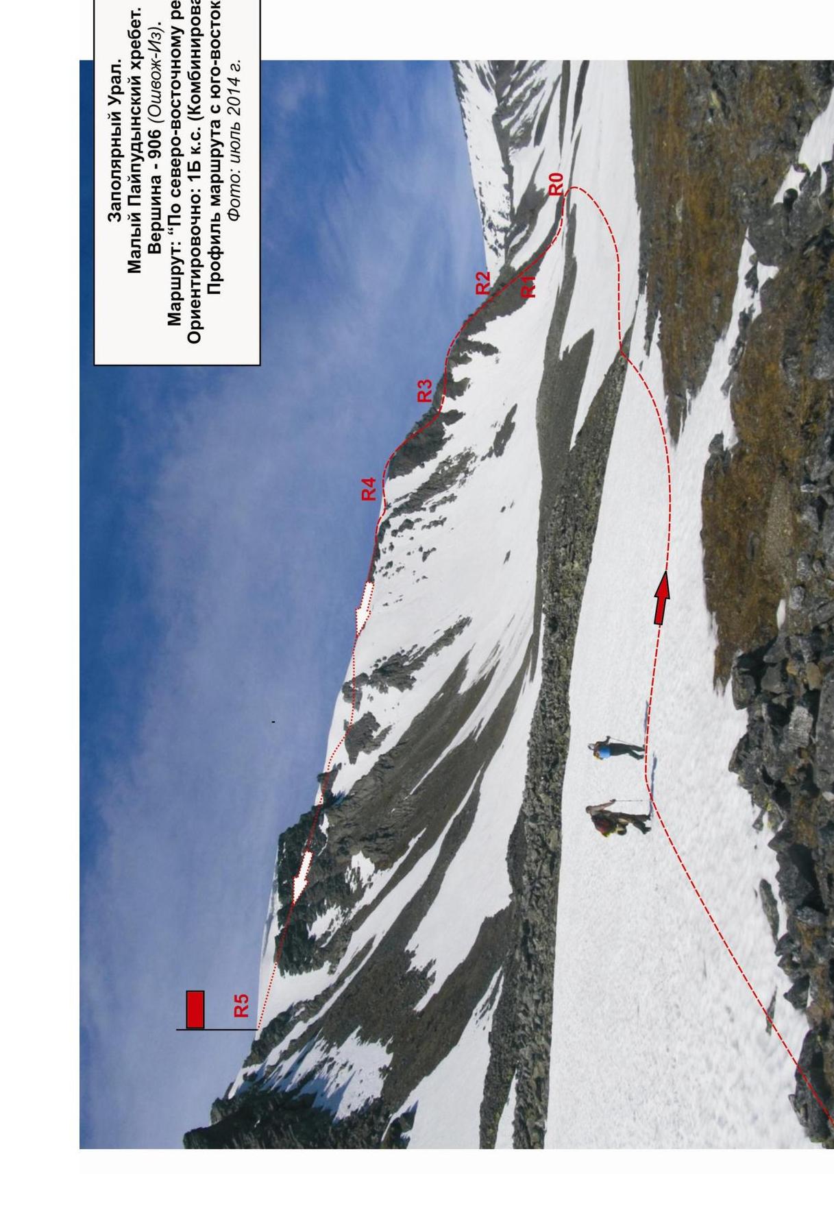
Transpolar Urals. Maly Pailyudyansky Ridge. Summit — 906 (Oshkож-Iz). Route: "Via the north-eastern ridge". Approximately: 1B cat. diff. (combined). Profile of the route from the south-east. Photo: July 2014.
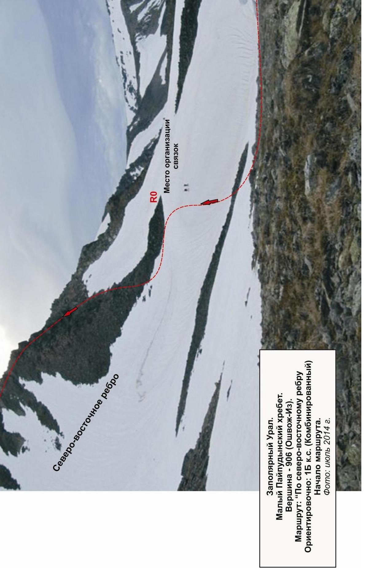
Transpolar Urals. Maly Pailyudyansky Ridge. Summit — 906 (Oshкож-Iz). Route: "Via the north-eastern ridge". Approximately: 1B cat. diff. (combined). Start of the route. Photo: July 2014.