Ascent Passport
Region — Subpolar Urals. Ridge — Research Range. Gorge — Manaraga River valley. Spur — mountain horseshoe of the Oleniy stream valley. Section number according to KMGV-2001 — 8. "Other mountain systems, massifs". Summit name — Kruzenshtern Peak. Height — 1462 m. Route name — via the South Ridge. Difficulty category — Proposed cat. diff. 1B. Route type: combined. First ascent. Height difference — 860 m. Route length — 3000 m. Sections of 5 cat. diff. — none. Sections of 6 cat. diff. — none. Average steepness of the main (technical part) of the route — 50–55°. Average steepness of the entire route — 31°. No pitons left on the route. Pitons were not used.
Team's travel hours:
- Approach from "Oleniy" refuge — 50 min.
- Ascent from "Priyut 'Oleniy'" bivouac — 6 hours.
Leader: Shulepov G. G. (1st sports category, instructor 3 cat., Syktyvkar) + 6. Participants:
- Zhuravlev S. V. (CMS, instructor 2 cat.) + 10 (NP-1 department).
Coach: Zhuravlev Sergey Vasilievich, CMS, instructor 2 cat. Departure to the route — 7:00, July 12, 2005. Summit reached — 13:00, July 12, 2005. Return to base camp — 18:00, July 12, 2005. Organization: Youth Interregional Scientific and Sports Expedition of Russian Germans and Alpine Federation of the Komi Republic "Polar Vertical — 2005".
Exec. Zhuravlev Sergey Vasilievich, Syktyvkar, 167000, Internatsionalnaya st., 97, apt. 12. Phone 24–24–91. E-mail: Zhur58@rambler.ru. Senior coach — Zhuravlev S. V. (No. 1124).
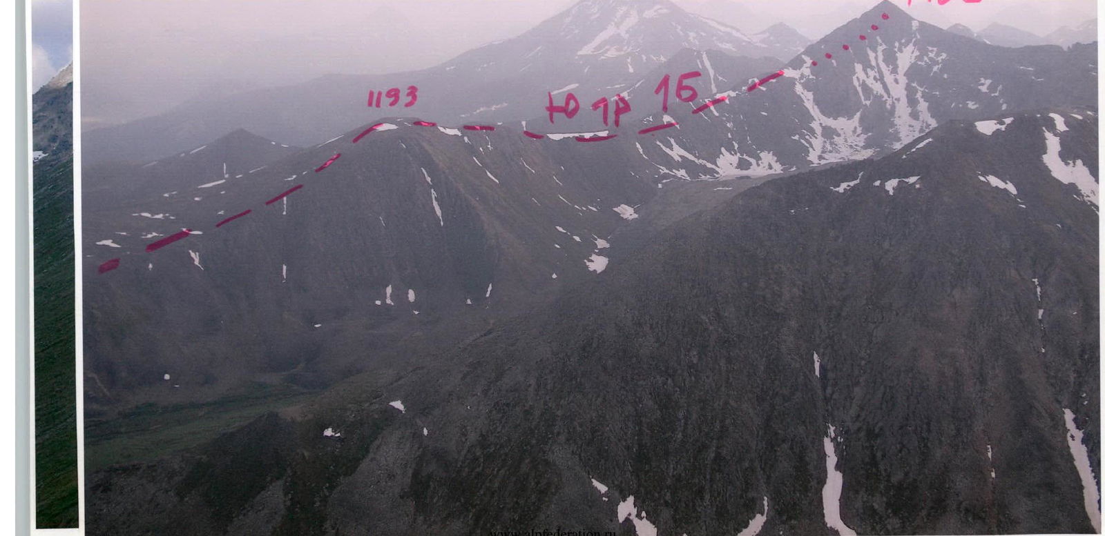
Manaraga 1662
p. Kruzenshterna 1462
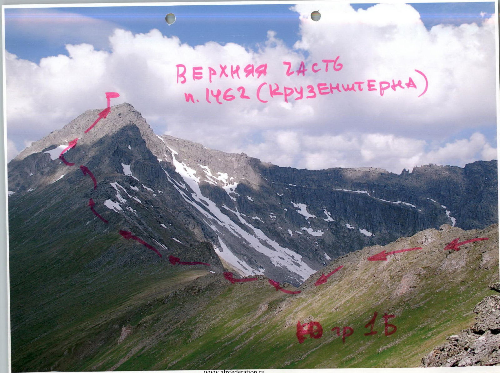
Upper part
p. 1462 (Kruzenshterna)
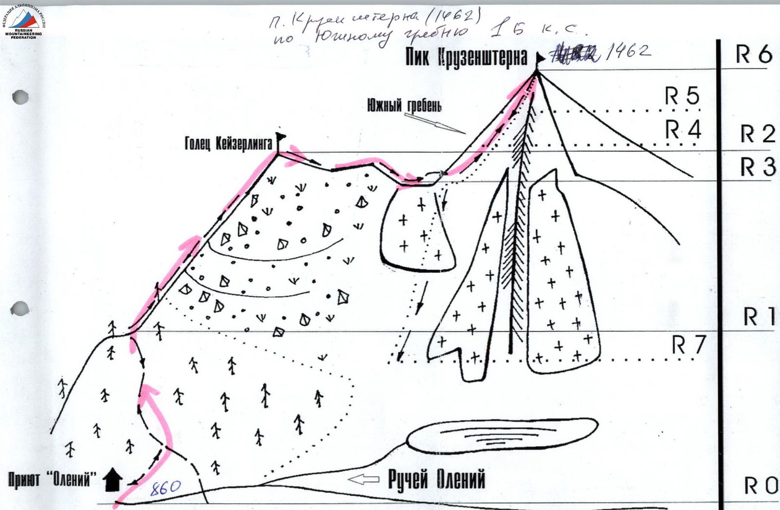
Ascent scheme in UIAA signs
- R0–R1 — approach to the base of the south ridge. (Trail, n.c.).
- R1–R2 — ascent to Keyserling bald peak. (Scree, kurumniks, n.c. 1 cat. diff.).
- R2–R3 — descent to the saddle. (Scree. Simple rocks. 600 m 1 cat. diff.).
- R3–R4 — ascent along the southern slope to the snowfield and right buttress. (Heavily destroyed rocks. 500 m 1 cat. diff.).
- R4–R5 — ascent along the buttress and traverse of the rocky summit ridge. (Rocky ridge, 50–75°. 300–350 m 1+, 2- cat. diff.).
- R5 — summit of Kruzenshtern Peak (1462).
- R5–R0 — descent via the ascent route.
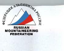
Profile of the south ridge of Kruzenshtern Peak (1462), 1B cat. diff. route
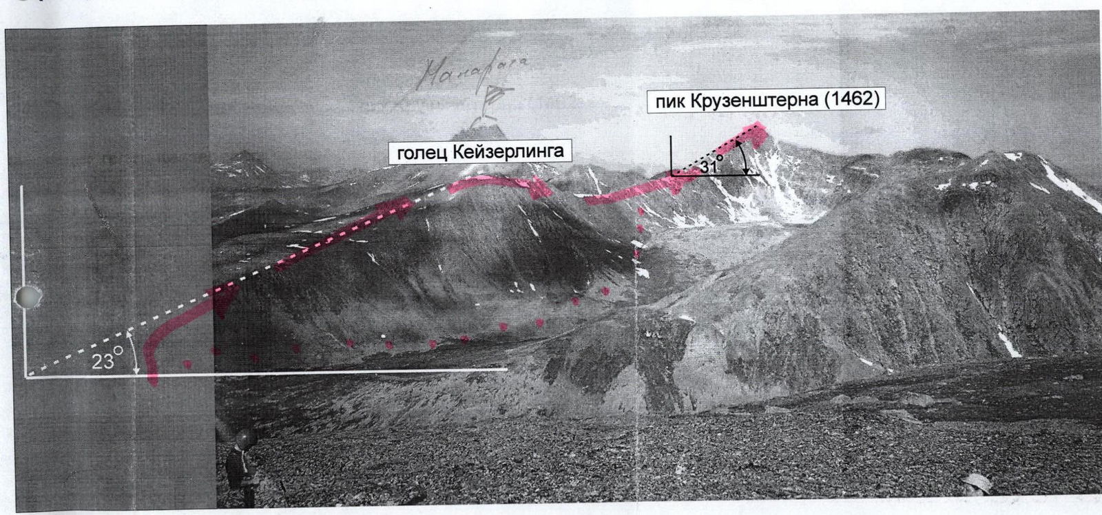
The route to Kruzenshtern Peak (1462) via the south ridge through Keyserling bald peak 1B cat. diff. consists of two parts:
- Ascent of the grassy and scree slope to Keyserling bald peak (1193) 1A cat. diff.
- Ascent from the saddle to the rocky tower of Kruzenshtern Peak.
The profile photo was taken from the south ridge of Pobeda Peak.
Description of the summit — object of sports ascents
Kruzenshtern Peak is located in the highest part of the Subpolar Urals, in the Research Range, in the Manaraga River valley, in the mountain horseshoe of the Oleniy stream. This is a well-defined rocky peak of alpine type with a height of 1462 m above sea level. The name — Kruzenshtern Peak — was given to this peak by participants of the youth sports and scientific mountaineering expedition of Russian Germans "Polar Vertical — 2005", after the first ascent of the south ridge in July 2005. The peak is interesting for mountaineers primarily due to:
- rocky ridges from the east and northeast;
- eastern and western slopes.
The ascent via the south ridge was made by mountaineers of the Interregional Youth Scientific and Sports Expedition of Russian Germans "Polar Vertical — 2005" in July 2005. Sports group of mountaineers (Shulepov+6) and educational and sports department NP-1 (Zhuravlev+10).
Description of the route — object of sports passage
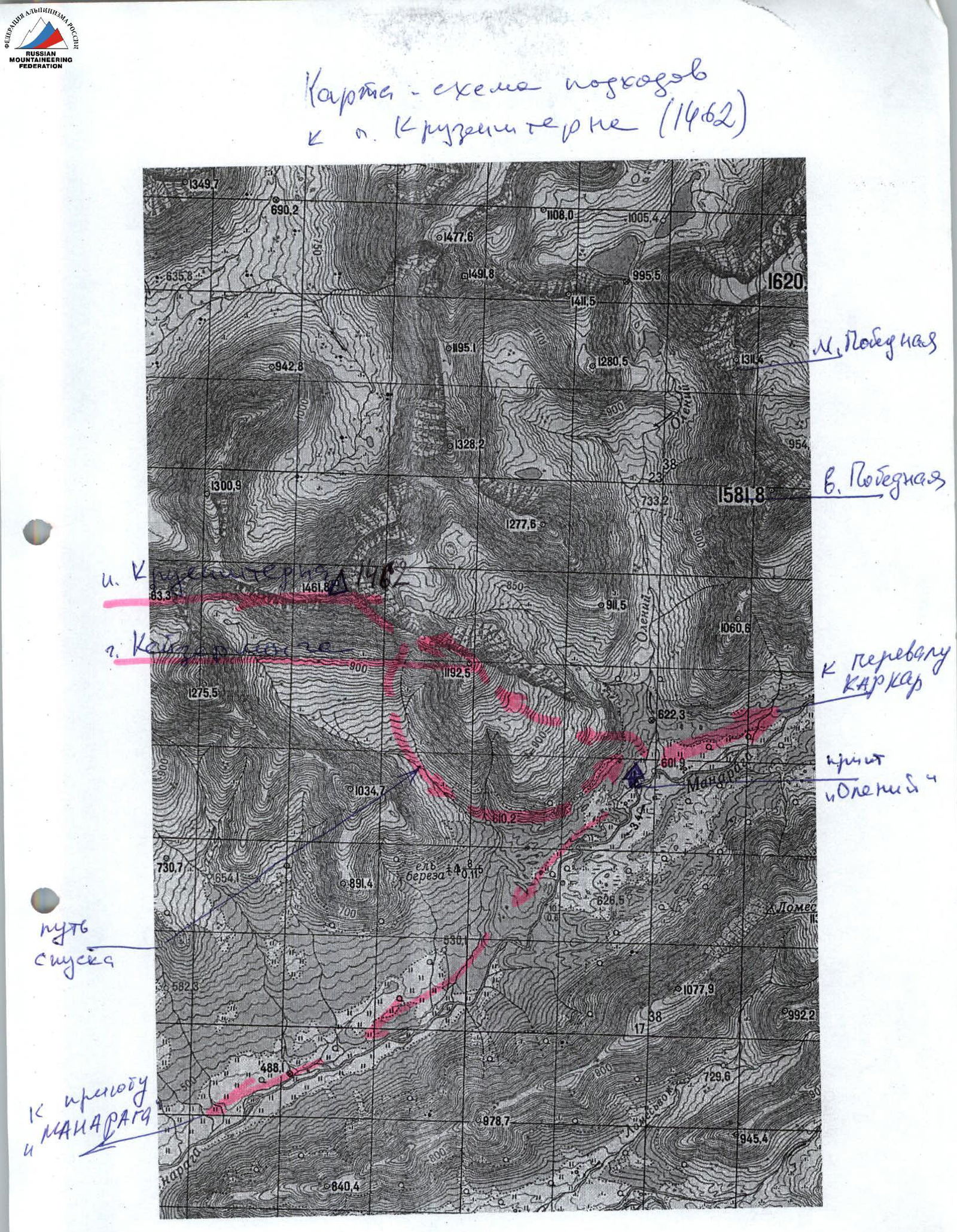
Approaches to the area of ascents ("PSP 'Manaraga'. Mountain horseshoe of Oleniy stream): From the Zhelannaya geologists' base, through Karpkar Pass, or Limbeko and Zigzag passes, cross into the Manaraga River valley and approach the "Oleniy" refuge. This is a cabin standing near the mouth of Oleniy stream, which flows into the Manaraga River. The transition takes two travel days.
Approach to the start of the route (OSV): from "Oleniy" refuge along a well-trodden geological and tourist trail leading downstream along the Manaraga River, ascend to the base of the north ridge. Further:
- From the lake, exit the forest zone via kurumniks and ascend to the bald peak zone.
- Then, along scree slopes, ascend to the summit of Keyserling bald peak (1A) (name proposed in the same mountaineering expedition) of the south ridge of Kruzenshtern Peak.
- Further along the ridge, transitioning from scree to rocky, heavily destroyed, consisting of large stone blocks, descend to the saddle between Keyserling bald peak and Kruzenshtern Peak.
- Along the ridge, via rocks of 1–2 cat. diff., to the left of the main south rocky ridge, exit to a weakly expressed buttress (right of the permanent snowfield).
- Along the rocks of the buttress, again exit to the south ridge.
- Further, traversing along the ridge with a small gain in height, exit to the summit of Kruzenshtern Peak.
The summit is sharp, peak-shaped. The site is small, allowing an mountaineering group of no more than 10 people to assemble.
At the summit:
- cairn;
- memorial sign of the "Polar Vertical — 2005" expedition.
Descent. The safest descent is via the ascent route.
In summer, a descent variant is possible:
- from the saddle between Keyserling bald peak and Kruzenshtern Peak — along the western slope into the valley of the nameless stream;
- further — along a weakly expressed trail to reach the geological trail running along the Manaraga River valley;
- along the trail, crossing in the forest zone the scree "claw" of the south ridge, return to the base bivouac near the refuge.
In winter, this descent variant is not recommended — avalanche hazard.
Required equipment (calculation made for NP-2 training group of 6 people):
- main rope — 2×40;
- carabiners — 3;
- rock pitons — 3;
- station loops — 2;
- primus stove — 1;
- pot — 1.
Time taken to complete the ascent: NP-2 department of 6 people from "Oleniy" refuge — 8–10 hours.