Mountaineering Route Passport
Mountain region — Balbanyu river valley Mountain range — Issledovatelsky Ridge Peak — Mount Karpinsky (1803) Route — via the south-west ridge Complexity category — 2A cat. (sk)
Alpinism Federation of the Komi Republic Syktyvkar city
Ascent Passport
- Region — Subpolar Urals
- Mountain range — Issledovatelsky Ridge
- Valley — Balbanyu river valley
- Section number according to KMGV-2001 — 8. "Other mountain systems, massifs"
- Peak name — Mount Karpinsky
- Height — 1803 m
- Route name — via the Western ridge
- Proposed category — 2A cat.
- First ascent
- Combined
- Height difference — 1320 m
- Route length — 2300 m
- Sections of 5th cat. difficulty — none
- Sections of 6th cat. difficulty — none
- Average steepness of the main (technical part) route — 55°
- Average steepness of the entire route — 35°
- No pitons left on the route
- Used on the route: 3 rock pitons, 8 chocks (stoppers and hexes)
Team's travel hours:
- Approach to the "Behind the all-terrain vehicle" bivouac — 1 day
- Ascent from the "Behind the all-terrain vehicle" bivouac — 10 hours
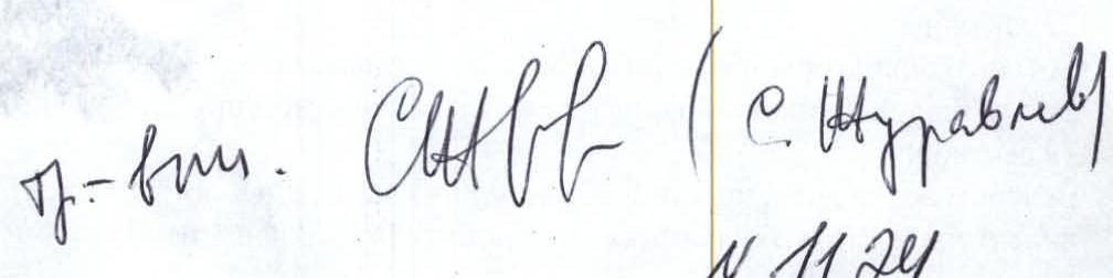
Leader: Zhuravlev Sergey Vasilyevich, CMS, 2nd cat. instructor
Climbing pair:
- Zhuravlev S. (CMS, 2nd cat. instructor, Syktyvkar)
- Eremkin M. A. (2nd sports category, 3rd cat. instructor, Syktyvkar)
Coach: Zhuravlev Sergey Vasilyevich, CMS, 2nd cat. instructor
Route start — 7:00, June 17, 2004 Summit — 12:00, June 17, 2004 Return to base camp — 14:00, June 27, 2004
Organization: Monitoring expedition of the "Yugyd Va" National Park and the Alpinism Federation of the Komi Republic "Polar Vertical - 2004"
Contact: Zhuravlev Sergey Vasilyevich, Syktyvkar, 167000, Internatsionalnaya st., 97, apt. 12. Phone: 24-24-91. E-mail: Zhur58@rambler.ru
 www.alpfederation.ru↗
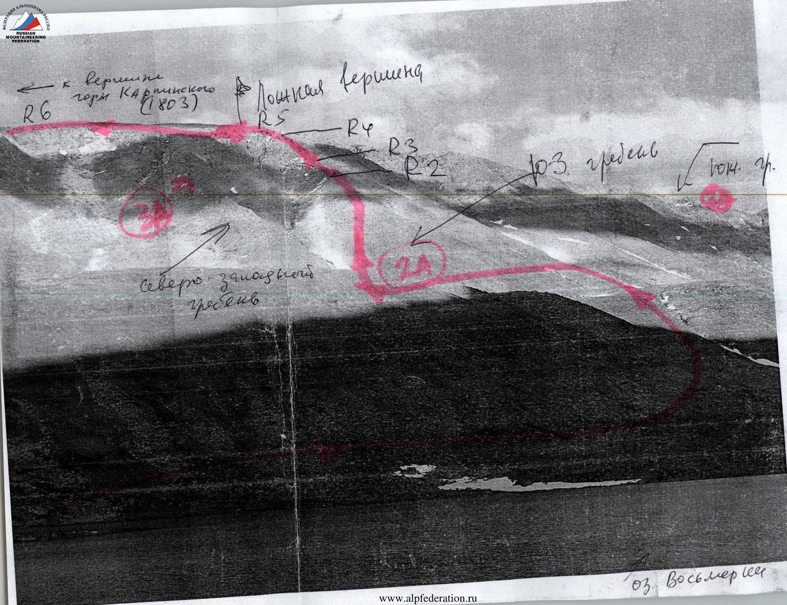
Route Diagram
to Mount Karpinsky via the Western Ridge, 2A cat.
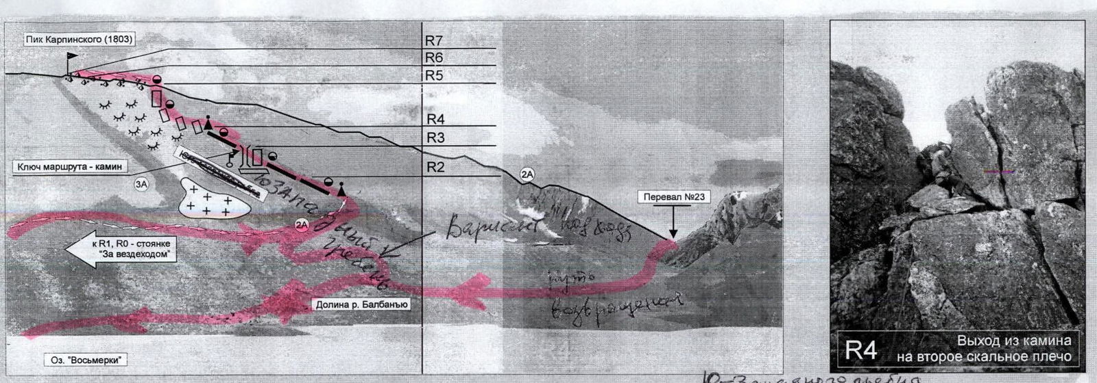
R0–R1 — Crossing the Balbanyu river, ascending via scree slopes to the base of the central buttress. (Scree. 1500 m, non-cat.) R1–R2 — Forming a rope team. Ascending along the ridge of the buttress to the first rocky shoulder.
- Rock
- 150–200 m
- 2–2+
- Average steepness — 35°
- Simultaneous movement with belay on outcrops R2–R3 — Passing the key section. Bypassing the rocky wall via a chimney on the left. (Rock. 10 m, 4–. Average steepness — 75°)
"Route key!"
R3–R4 — Reaching the second rocky shoulder of the buttress. (Rock. 500 m. 2–2+. Average steepness — 15–20°)
- Simultaneous belay with rope placement on outcrops
- Simultaneous movement on a shortened rope
"Control cairn"
R4–R5 — Reaching the southern ridge via a series of alternating rocky walls. (Rock. 300 m. 5–10 m high, varying steepness. 3–3+). R5–R6 — Crossing the pre-summit plateau. (Scree. 200 m, non-cat.) R6–R7 — Ascending to the summit tower. (Rock. 15 m. 1, 2–) R7 — Summit of Mount Karpinsky. R7–R0 — Descent to the east. (Via the 1B cat. route)
Peak — Mount Karpinsky (1803)

Mount Karpinsky, 1803 m above sea level, is the second highest peak in the Urals and the highest peak in the Komi Republic. Located in the Issledovatelsky Ridge, on the border between Europe and Asia, between the mountain massifs of Mount Staruha (1439 m) and Mount Narodnaya (1895 m). Discovered in 1927. Named after the first president of the USSR Academy of Sciences, A. P. Karpinsky (1847–1936). Several routes lead to the summit of Mount Karpinsky, both from the west (from Europe) and from the east (from Asia). A distinctive feature of all routes is their considerable length:
- The technical part of each route is over 2000 m long.
- The routes are structured in steps: short, complex rocky walls alternate with lengthy ridge sections.
- The height difference from the base camp is over 1500 m. Another common feature of all routes is the climate:
- From October 15 to May 25, the routes to Mount Karpinsky are combined.
- From May 25 to October 15, the routes are rocky.
Route Description (OSP)
Approach: From the geologists' base — Zhelanny settlement — upstream along the Balbanyu river valley, on the left (in the direction of travel) bank. 3–4 hours to the reindeer herders' camp near Maly Balbanty lake (fording a mountain stream before the camp), approximately the same time upstream to the traditional bivouac on the slopes of Mount Narodnaya below the Limbeiko pass. A bright landmark on the approach is a burnt-out all-terrain vehicle. Near it, one should cross the Balbanyu river via boulders. Further, from the remains of the all-terrain vehicle to the traditional camps under the slopes of Mount Narodnaya — less than an hour's walk. Technical part of the route: From the bivouac below the Limbeiko pass, cross the Balbanyu river via boulders and begin ascending through tundra, transitioning into medium-blocky talus, in the direction of the not-very-pronounced rocky ridge of Mount Karpinsky. Tie in at the base of the ridge. Further movement is via rocks of 1, 2– difficulty. Emerging onto the rocks in the middle part of the ridge. Simultaneous movement with belay on outcrops. Reaching the first rocky shoulder. A 10 m rocky wall of 5th category difficulty is bypassed on the left via a chimney of 3+–4- category difficulty. ("Route key!") In June, the chimney is filled with ice. Movement is in opposition along the edges of the chimney walls. Piton belay, with the organization of handrails. After passing the key section, movement is along the ridge, via rocks of below-average difficulty (2–2+), to the second shoulder of the ridge. Simultaneous movement on a shortened rope. Belay organization on ridge outcrops. On the second rocky shoulder, a control cairn is built. After the second rocky shoulder, the complexity and steepness of the rocks increase to average difficulty, but not higher than 3– and on individual sections 3+ category difficulty. This section is not lengthy and leads to a junction with the southern ridge on a false summit. The southern ridge is spacious and non-categorical. Further:
- Emerging onto the pre-summit plateau
- Movement across it towards the rocky tower The summit is a 10–15 m rocky tower. Rock difficulty 1. Descent from the summit is via a broad snowy couloir (the third from the summit in a northerly direction) into the Balbanty river valley. Does not present technical difficulty. In winter:
- The couloir is avalanche-prone
- Recommended descent is via the Asian slope, into the Karpinsk-Shor stream and Goluboye Lake, via the 1B category route.
- Further return to the bivouac via the 23rd pass. Required special mountaineering equipment for a two-person sports group:
- Climbing rope — 1 × 50 m
- Climbing pitons — 5 pcs.
- Quickdraws — 5 pcs.
- Anchor slings — 5 pcs.
- Ice axes — 2 pcs.
- Climbing carabiners (shared) — 5 pcs.
- Crampons — 2 pairs
- Stove (gas burner) with a pot — 1 pc.
- Poncho capes — 2 pcs.
Summit Description (OSV)
Mount Karpinsky is the second highest peak in the Urals — 1803 m above sea level. It is a large mountain massif on the border between Europe and Asia. Among Russian, near-abroad, and international mountaineers and tourists, it is not among the most attractive peaks in the Urals. At the same time, as a sports ascent object, Mount Karpinsky is quite appealing, as it has several pronounced ridges and buttresses on both the European and Asian sides. The names of the first ascenders to Mount Karpinsky should be sought in the lists of geodetic expeditions of the 1930s, or even earlier. The first ascent for the installation of a triangulation marker was likely made from Goluboye Lake via the eastern slopes. In the classification of mountaineering routes, Mount Karpinsky appeared in the 1990s after a group of Syktyvkar mountaineers completed a winter traverse "Mount Karpinsky — Mount Narodnaya, 1B category". The mountaineering feature of the route is the height difference from 500 m above sea level at the base of the mountain to 1803 m at the summit. The route is characterized by dense rocks allowing participants to practice all techniques of belay and self-belay (NP-2 stage):
- Simultaneous, alternating movement on rocky terrain,
- Alternating movement on rocky terrain,
- Interaction between rope teams ("on the route key"). On the descent — interaction between rope teams on snowy terrain. It is clear that after the route classification, Russian mountaineers' interest in this peak will increase, as it will provide another opportunity to fulfill normative and category requirements at this attractive natural object within the framework of departure sports training camps, mountaineering expeditions dedicated to significant historical events.
Profile of the Western Slope of Mount Karpinsky (1803)
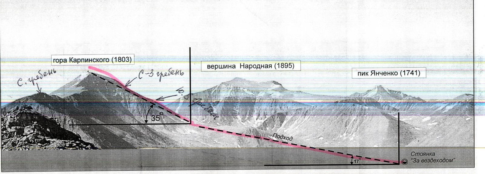
Several mountaineering routes are laid out along the buttresses of the western slope of Mount Karpinsky. The average steepness of these routes is 35°. Nevertheless, one should consider the rocky-stepped structure of these routes, where each step of the ridge or buttress is separated from the above ones by rocky walls 15–40 m high, with varying steepness:
- From 15° on ridge sections
- To 75° on wall sections The routes along the buttresses of the western slope of Mount Karpinsky are lengthy and require the presence of camping equipment for the sports group. The photo of the western slope profile of Mount Karpinsky was taken from the summit of Mount Staruha.
Map-diagram of the approach and ascent to Mount Karpinsky via the Southwest Ridge, 2A cat.
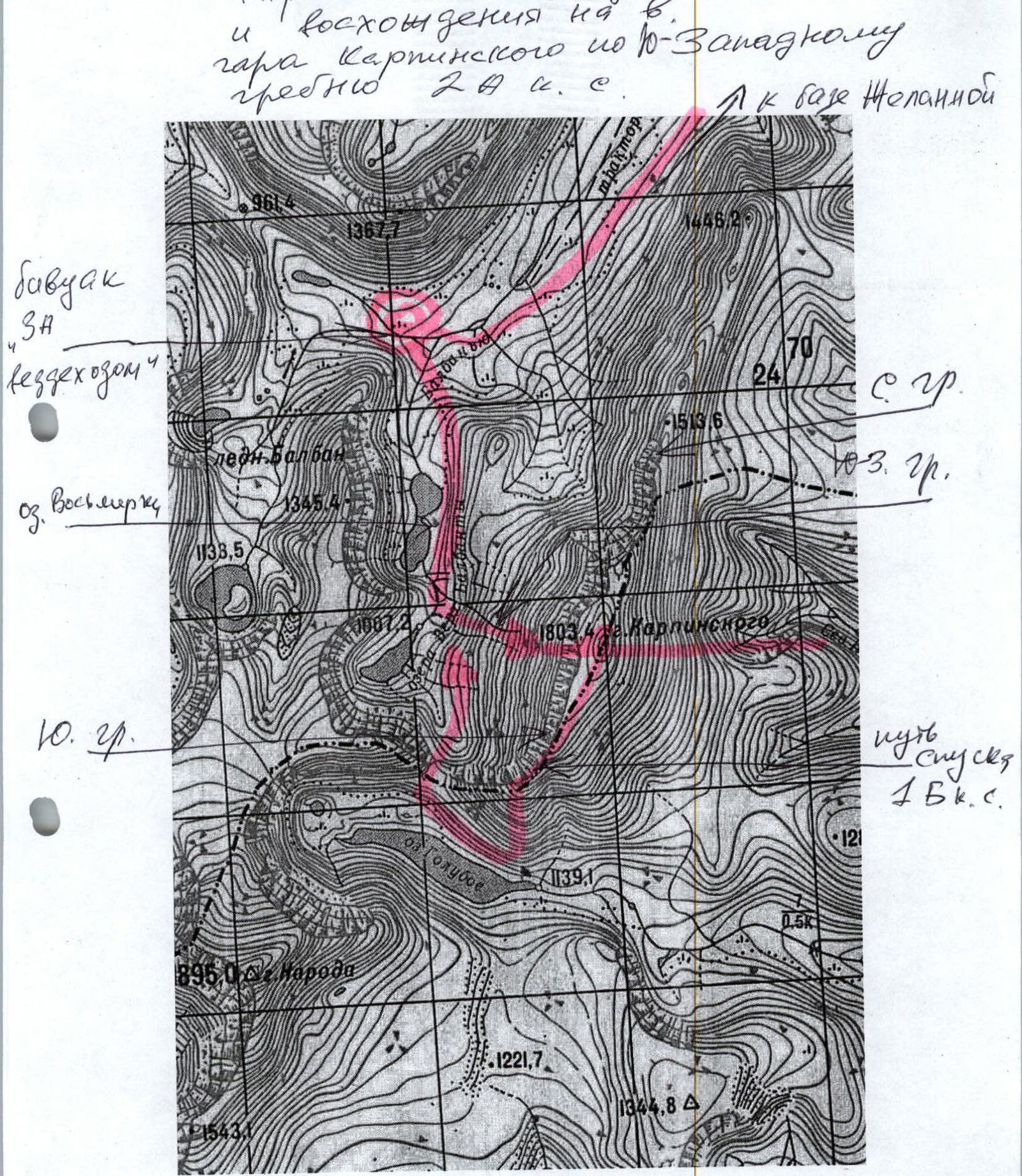
M: 1 cm – 500 m