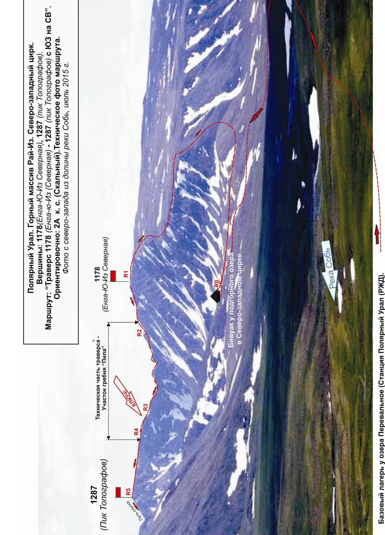
Polar Urals. Rai-Iz mountain range. North-West cirque. Peaks:
- 1178 (Enga-Yu-Iz Northern)
- 1287 (Topografov Peak)
Route: "Traverse 1178 (Enga-Yu-Iz Northern) — 1287 (Topografov Peak) from SW to NE". Approximately: 2A cat. diff. (Rocky). Technical photo of the route. Photo from the north-west from the Sob river valley, July 2015.
Passport
- Section number according to KMGV — 2010 — 8.3.
Polar Urals, Raiiz mountain range, Sob river valley.
- Names of the peaks: Peak 1176 (Enga-Yu-Iz Northern) and 1287.0 (Topografov Peak)
Height: 1176 and 1287.0 Route: traverse 1176 (Enga-Yu-Iz Northern) — 1287 (Topografov Peak) from west to east.
- Category of difficulty: proposed 2A cat. diff., PP.
- Character of the route — combined.
- Height difference of the route: 520 m
- Length of the route: 00 m
- Length of sections with the highest cat. diff.:
1 cat. diff. — 2 sections — 650 m, 2 cat. diff. — 2 sections — 270 m, 3 cat. diff. — 1 section — 5 m, 4 — 0 m, 5 — 0 m, 6 — 0 m.
- Average steepness: total route — 35°.
9. Number of pitons used:
Total pitons used on the route:
- Rock pitons — 0
- Chocks — 6
- Stationary bolt pitons — 0
- Ice screws — 0
- Removable bolt pitons — 0
Left "pitons" on the route: total — 0; incl. bolt pitons — 0.
- Departure to the route — 8:00, June 27, 2015.
Reached the summit — 15:30, June 27, 2015. Returned to the base camp — 18:00, June 27, 2015.
- Team's walking hours: — 10 hours.
- Leader: Babkin V.V. (Candidate for Master of Sports, instructor-methodologist 3rd category, Ekaterinburg).
Team members:
- Nuzhnaia D.P. (3rd sports category, Syktyvkar)
- Nuzhny P. (3rd sports category, Syktyvkar)
- K. Tolstikov (3rd sports category, Syktyvkar)
- Sheshukov Roman (3rd sports category, Ukhta)
- Radushkevich A. (3rd sports category, Ukhta)
- Coach: Zhuravlev Sergei Vasilievich, rank — Candidate for Master of Sports, instructor-methodologist 1st category.
Description of the peaks
Peak 1176 (Enga-Yu-Iz Northern) — the northernmost of the three peaks of the Enga-Yu-Iz mountain, part of the Rai-Iz mountain range in the Polar Urals. Located in the Yamalo-Nenets Autonomous Okrug (YaNAO) of the Tyumen region, Ural Federal District, Russian Federation, in the upper reaches of the Sob river, in the north-western cirque of the Rai-Iz massif.
Peak 1176 (Enga-Yu-Iz Northern):
- a pronounced mountain, easily identifiable from the Polar Urals railway station;
- the name is not indicated on the General Staff's kilometer grid map, determined orographically relative to the main peak of the Enga-Yu-Iz mountain for identification purposes.
There are currently no classified routes to the summit of 1176 (Enga-Yu-Iz Northern). The exploration of the climbing resources of these peaks continues.
Peak 1287 (Topografov Peak) — one of the most interesting peaks for climbers in the Raiiz mountain range, located in the Yamalo-Nenets Autonomous Okrug (YaNAO) of the Tyumen region, Ural Federal District, Russian Federation, on the eastern slopes of the Polar Urals, on the watershed of the mountain valleys of the:
- Sob (west)
- Enga-Yu (south-east)
Peak 1287 (Topografov Peak) — a pronounced rocky truncated pyramid with a flat summit. Height — 1287.0 m. The name is unofficial but has become established in the tourist-climbing community, likely related to the officially named Topografov glacier located on the south-eastern slopes of this mountain.
Two routes are classified to the summit of 1287 (Topografov Peak):
- Along the NW ridge — 1B cat. diff. (winter);
- Traverse 1309 (Polar Peak) — 1287 (Topografov Peak) 2B cat. diff. from NW to NE (winter).
Description of the route
The route "Traverse of peaks 1176 (Enga-Yu-Iz Northern) — 1287 (Topografov Peak) from west to east" — is a training and sports combined route 2A, with a full range of natural rock obstacles. The route is logical and easily identifiable.
Completing this route has not only aesthetic but also practical and sports significance, as it allows for the practice of various techniques during the ascent:
- belaying
- self-belaying
on a prolonged rocky terrain.
Equipment
For the ascent as part of a training and sports group of 4 people (3 participants + instructor), the following special equipment is required on the route:
-
Personal — standard, including crampons and ice axe
-
Group:
- Main rope 10 mm — 2×50 m
- Rock hammer — 1 pc.
- Rock pitons — 4 pcs.
- Ice axe — 1 pc.
- Chocks — 12 pcs.
- Quickdraws — 10 pcs.
- Slings — 10 pcs.
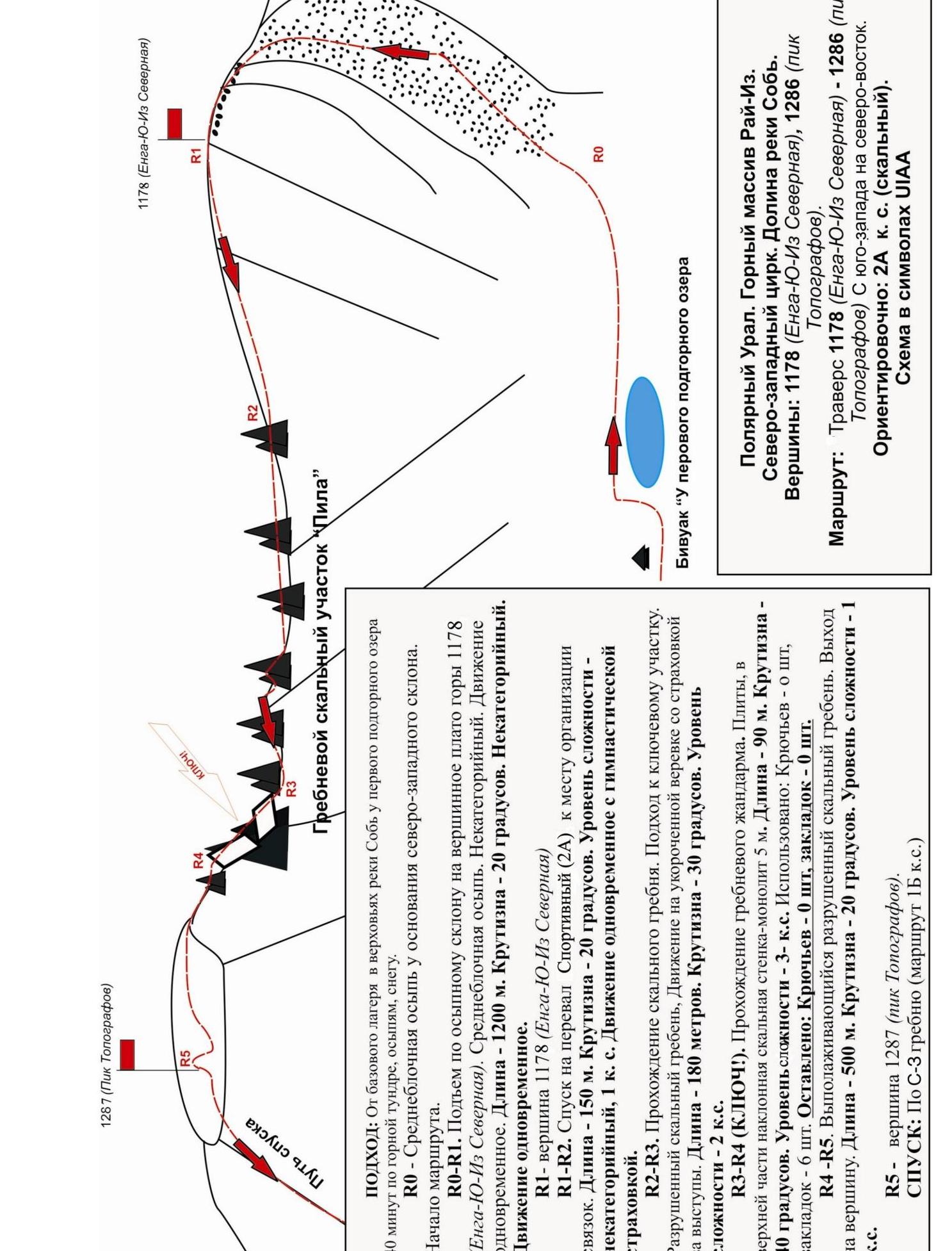
Approach
The ascent starts from the "First sub-mountain lake" campsite.
Approach to the campsite:
- From the Polar Urals railway station and the base camp near the Perevalnoe lake, walk upstream along the left bank of the Sob river.
- In the upper reaches of the river, cross (possibly ford) to the right bank.
- Ascend via scree and mountain tundra to the first sub-mountain lake in the north-western cirque of the Rai-Iz massif.
At the lake:
- There are convenient places for tents.
- There are convenient, dense natural rocks suitable for training.
Approach to the start of the route:
- Return via the approach path to the western scree slope.
- Ascend it to the summit of 1176 (Enga-Yu-Iz Northern).
The path is long and non-technical, due to the fact that the ascent to the "Sob — Enga-Yu" pass (in cat. diff. 2Az) is objectively rockfall-prone in the summer.
Then descend from the summit of 1176 (Enga-Yu-Iz Northern) by 100–150 m and organize a rope team on a suitable platform before the rocky ridge.
Technical part
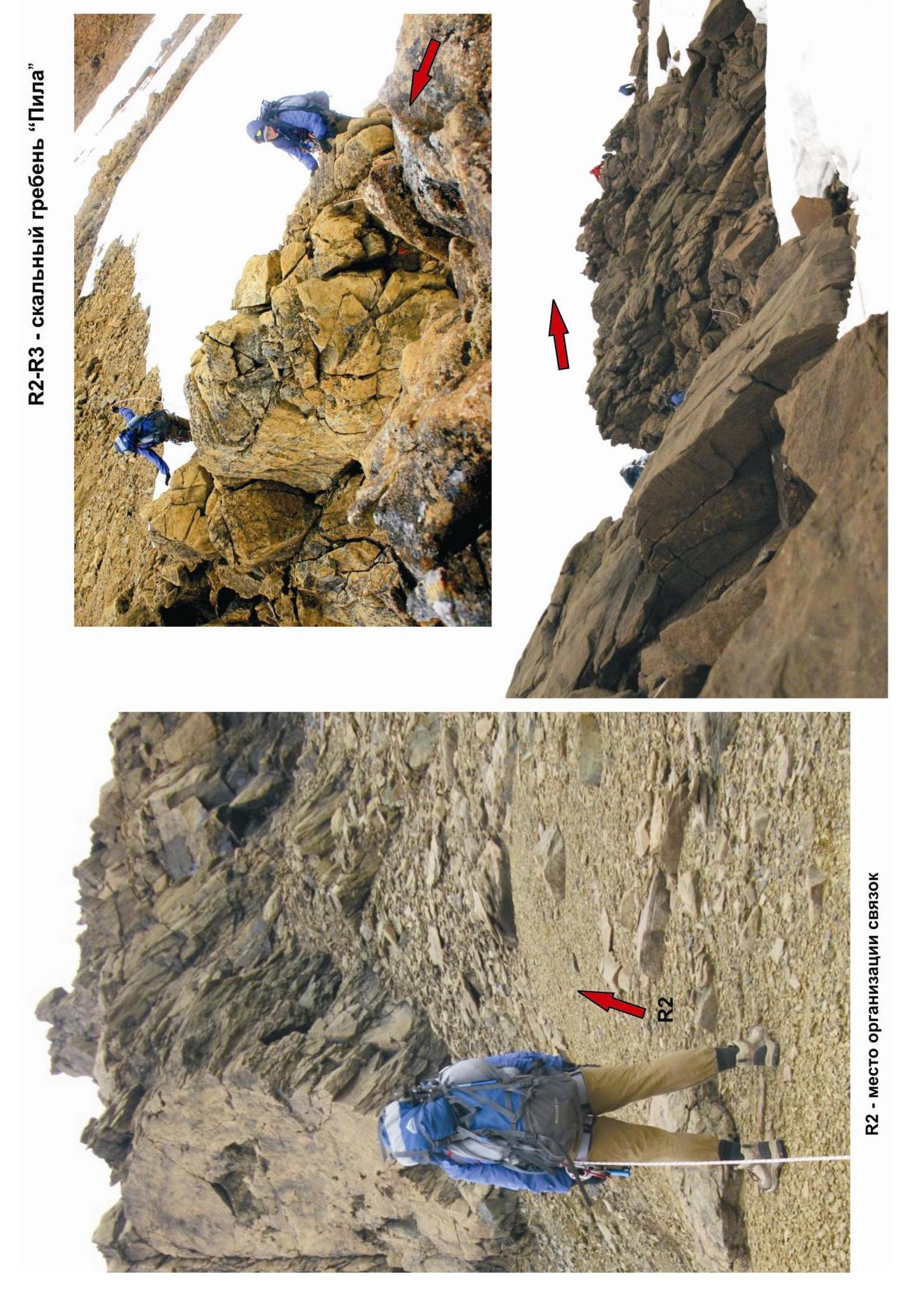
The technical part of the route begins with a descent along the jagged rocky ridge to the Southern Karovyi pass. Movement along the ridge with the overcoming of a series of small gendt teeth requires alternate belaying on individual sections. Belaying is carried out using the rocky terrain and large slings thrown over ledges. Finding intermediate belay points does not present difficulties.
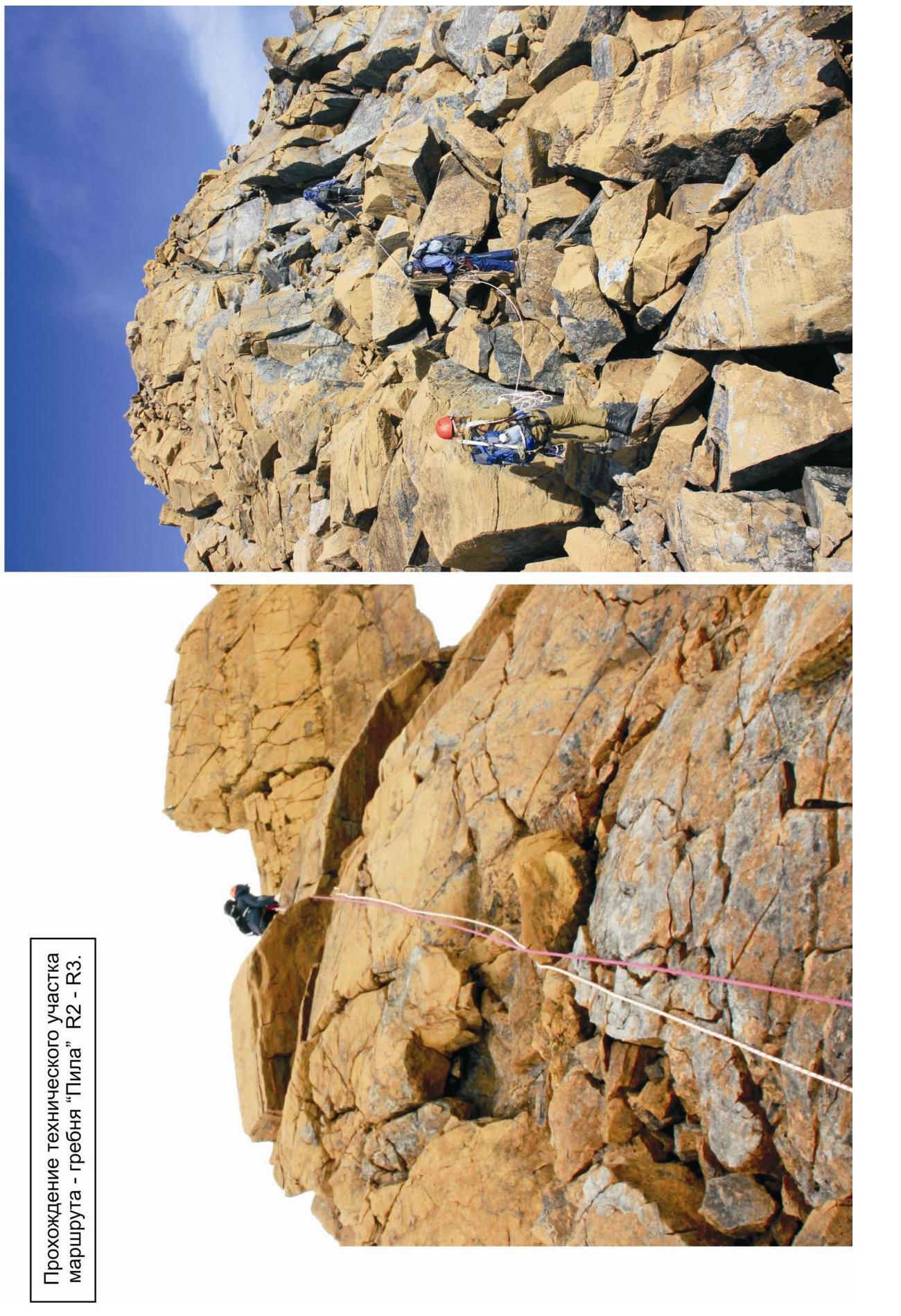
From the Karovyi pass, begin the ascent along the jagged rocky ridge "Pila" and with alternate belaying, approach the pre-summit gendarme. The "Pila" section is long. The passage requires technical and tactical skills. The rocks are dense. The difficulty is at the level of 2B, but there are short sections of 3–5 m at 3B, requiring mandatory intermediate belay points.
The key to the route: the pre-summit gendarme in the rocky ridge "Pila", leading from the Southern Karovyi pass to the summit.
The pre-summit gendarme of the rocky ridge "Pila" can only be passed "head-on" along dense rocks:
- In the lower part — smoothed slabs;
- In the upper part — a rocky wall 5 m with complicated climbing.
For intermediate points, chocks — stoppers of medium numbers were used.
After passing the key section, bypass the large pre-summit gendarme at the base along the scree on the right. Then exit via a not very difficult, flattening towards the summit, rocky ridge. The ridge leads to the summit plateau.
Summit
Pronounced. A cairn is located in the center. A note from a group of tourists from Magnitogorsk was found.
Descent from the summit
The descent from the summit is carried out: along the north-western ridge to the Northern Karovyi pass (route 1B cat. diff.). Then down the snowy couloir to the bivouac at the first sub-mountain lake.
Recommendations to the instructor
The route corresponds to traditional routes of cat. diff. 2A in other mountain regions of the Russian Federation, can be used for training groups NP-2, as a qualifying ascent. Allows for the practice of various techniques of movement and belaying on rocky terrain.
Route analogues: traverse of Sulahat (Western Caucasus. Dombay) — 2A.
Polar Urals. Rai-Iz mountain range, north-western cirque
Peak:
- 1176 (Enga-Yu-Iz Northern)
- 1287 (Topografov Peak)
Route: "Traverse of peaks 1176 (Enga-Yu-Iz Northern) — 1287 (Topografov Peak) from west to east"
Difficulty level: approximately — 2A cat. diff. (rocky) (table of natural obstacles on the route)
| Section # | Length | Steepness | Terrain characteristics | Cat. diff. | # of pitons/chocks |
|---|---|---|---|---|---|
| APPROACH | From the base camp in the upper reaches of the Sob river to the first sub-mountain lake — 40 minutes along the mountain tundra, scree, snow. | Photo #1 | |||
| R0 — Medium-block scree at the base of the north-western slope | Second sub-mountain lake — start of the route. | ||||
| R0–R1 Ascent via scree slope to the summit plateau of peak 1176 (Enga-Yu-Iz Northern) | 1200 | 15–20 | Medium-block scree. | H/K | Used 0/0 Left 0/0 Photo #2 |
| R1 — Summit 1176 (Enga-Yu-Iz Northern) | Wide, inclined to the southwest, scree plateau | ||||
| R1–R2 Descent to the Sportivny pass. Location of rope team organization. | 150 | 20 | Medium-block scree. Large rocky blocks. Movement with gymnastic belaying. | 1 | Used 0/0 Left 0/0 Photo #3 |
| R2–R3. Passage of the rocky ridge "Pila". Approach to the key section. | 180 | 30 | Reasonably rocky ridge. Movement on a shortened rope with belaying for ledges. | 2 | Used 0/6 Left 0/0 Photos #4, 5 |
| R3–R4 (KEY!) Passage of the ridge gendarme | 90 | 40 | Slabs, in the upper part — inclined rocky wall, monolith 5 m | 2 + 3 - | Used 0/6 Left 0/0 Photo #6 |
| R4–R5. Flattening, destroyed rocky ridge. Exit to the summit. | 500 | 20 — 10 | Destroyed rocky ridge, movement on a shortened rope with belaying for ledges. | 1, H/K | Used 0/0 Left 0/0 Photo #7 |
| :--: | :--: | :--: | :--: | :--: | :--: |
| R5 — Summit 1287 (Topografov Peak) | Small scree plateau | Photo #7 | |||
| DESCENT | Along the south-eastern ridge via route 1B cat. diff. |
Total
Route length — 2120 m. Average steepness — 25°
Terrain character — rocky. Technical sections:
- 1 cat. diff. — 2 sections — 650 m
- 2 cat. diff. — 2 sections — 270 m
- 3 cat. diff. — 1 section — 5 m
- 4 cat. diff. — 0 sections — 0 m
- 5 cat. diff. — 0 sections — 0 m
- 6 cat. diff. — 0 sections — 0 m
Pitons and chocks used: 0/6 pcs. Left pitons and chocks: 0/0 pcs.
R2–R3 — rocky ridge "Pila"
R2–R4. Characteristic rocks of the technical section of the route — ridge "Pila". Photo: July 2015.

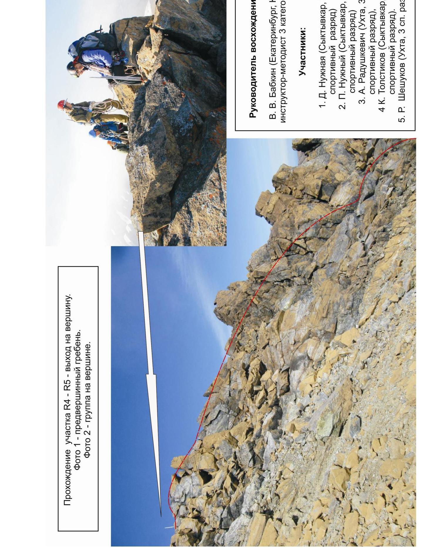
Ascent leader: V.V. Babkin (Ekaterinburg, Candidate for Master of Sports, instructor-methodologist 3rd category).
Team members:
- D. Nuzhnaia (Syktyvkar, 3rd sports category)
- P. Nuzhny (Syktyvkar, 2nd sports category)
- A. Radushkevich (Ukhta, 3rd sports category)
- K. Tolstikov (Syktyvkar, 3rd sports category)
- R. Sheshukov (Ukhta, 3rd sports category)