Passport
- Section number according to KMGV — 2010 — 8.3.15
Polar Urals, Raiiz mountain range, Nyrd-Vomen-Shor river valley.
- Name of the peak: 1159.0 (Dinozavr Gl.) — 1060.0 (Dinozavr V.)
height: 1159.0–1060.0 route: via the central couloir (cross)
- Category of complexity: Proposed 1B category, PP.
- Nature of the route — combined.
- Height difference of the route: 900 m (according to the 1964 General Staff map)
Route length: 4500 m Length of sections with the highest category of complexity:
1–3200 m; 2–500 m; 3–0 m; 4–0 m; 5–0 m; 6–0 m
Average steepness: main part of the route — 45°, entire route — 65°.
- Total used on the route: rock pitons — 0, chocks — 0.
Pitons used:
bolted stationary — 0
ITO — 0
bolted removable — 0.
Pitons left on the route: total — 0; including bolted — 0.
- Departure on the route — 7:00, July 2, 2008
Reached the summit — 11:30, July 2, 2008
Returned to BL — 14:00, July 2, 2008
- Team's walking hours: 7 hours.
- Leader: Kremen Anatoly Alekseevich, CMS, 1st category instructor-methodologist;
Participants:
- N. Kondratieva (3rd sports category, Syktyvkar)
- Yu. Valuzhis (2nd sports category, Syktyvkar)
- A. Kondratieva (3rd sports category, Syktyvkar)
- A. Maksimov (3rd sports category, Syktyvkar)
-
Coach: Zhuravlev Sergey Vasilievich, title — CMS, 1st category instructor-methodologist.
Description of peaks 1159 (Dinozavr Gl.) and 1080 (Dinozavr V.)
The peaks — 1159 m (Dinozavr Glavny) and 1080 m (Dinozavr Vostochny) — are the two main peaks of the Dinosaur mountain, separated on the northern slope by the central couloir. Both peaks have independent significance as objects for sports and training ascents. The Dinosaur mountain in the Polar Urals is the most popular among alpinists, and therefore the most developed.
Description of the route via the central couloir ("Kрест")
The route is well visible from the Nyrdvomen-Shor stream valley, logical in orientation. It belongs to combined training and sports routes of 1st category of complexity. Allows to work out movement on all forms of mountain relief with a training group.
Equipment
For an ascent with a training and sports group of 6 people (5 participants + instructor) on the route, the following special equipment is necessary:
Personal:
- Standard issue
Group:
- Main rope 10 mm × 3 pcs × 50 m
- Rock hammer — 1 pc
- Ice axe — 1 pc
- Rock pitons — 2 pcs
- Chock nuts — 4 pcs
- Ice screws — 2 pcs
- Quickdraws — 4 pcs
- Slings — 6 pcs
Approach
From the base camp in the Nyrdvomen-Shor stream valley:
- Cross the river by ford.
- Move along the left bank of the Nyrdvomen-Shor stream, bypassing the green hill.
- Advance along the talus, moss-covered, tundra slopes.
- Approach the stream.
- Ascend the stream to the base of the central couloir.
- Organize rope teams in the snow cirque.
Technical part
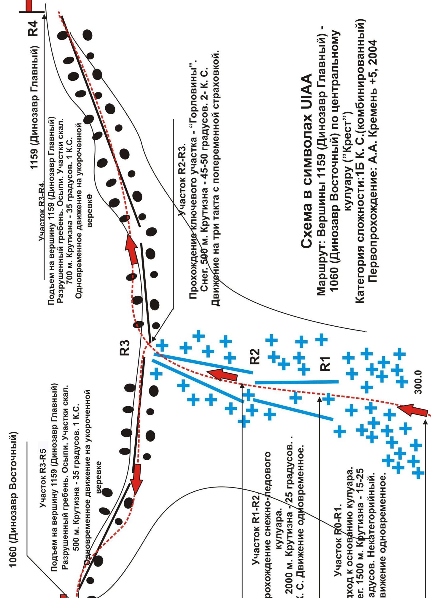
The route is easily identifiable by characteristic features: a pronounced couloir, separating two peaks of the mountain. Uniform ascent to the saddle. In the middle part, movement is in three tempos.
In the spring months, small avalanches are possible from the slopes of peak 1159 (Dinozavr Glavny), it is recommended to press to the left towards the slopes of peak 1060 (Dinozavr Vostochny).
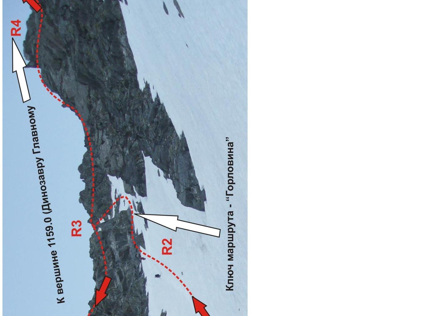
Key — "Gorlovina": the narrowest and steepest part of the couloir, divided by large stone blocks.
- In summer (July–August) — open ice.
- Alternate movement.
- If necessary, organization of mass insurance — fixed rope.
- Organization of alternate insurance in the presence of snow — with an ice axe.
- In other cases — through large stone blocks.
- It is convenient to use large loops made of webbing or main rope.
After reaching the saddle:
- Ascend to the right along the eastern ridge (simple destroyed rocks) to the summit of 1159 (Dinozavr Glavny).
- Return — ascend along the western ridge (simple destroyed rocks) to the summit of 1060 (Dinozavr Vostochny).
- Descend back to the saddle.
- From the saddle, descend to the southeast along the snowy couloir.
Descent from the summit
Descend down the eastern snowy couloir to the parking lot (abandoned geologists' base) "Nephrite stream". From the Nephrite stream, follow the all-terrain vehicle road back to the base camp. The most challenging part of the descent is crossing the Nyrdvomen-Shor:
- Most often (until June 25) carried out across snow-ice bridges
- In July–August — by fording
1060 (Dinozavr Vostochny) Route:
via the central couloir "Kрест" Category of complexity: 1B (combined)
First ascent: A. A. Kremen
+5
Route:
via the central couloir "Kрест" Category of complexity: 1B (combined)
First ascent: A. A. Kremen
+5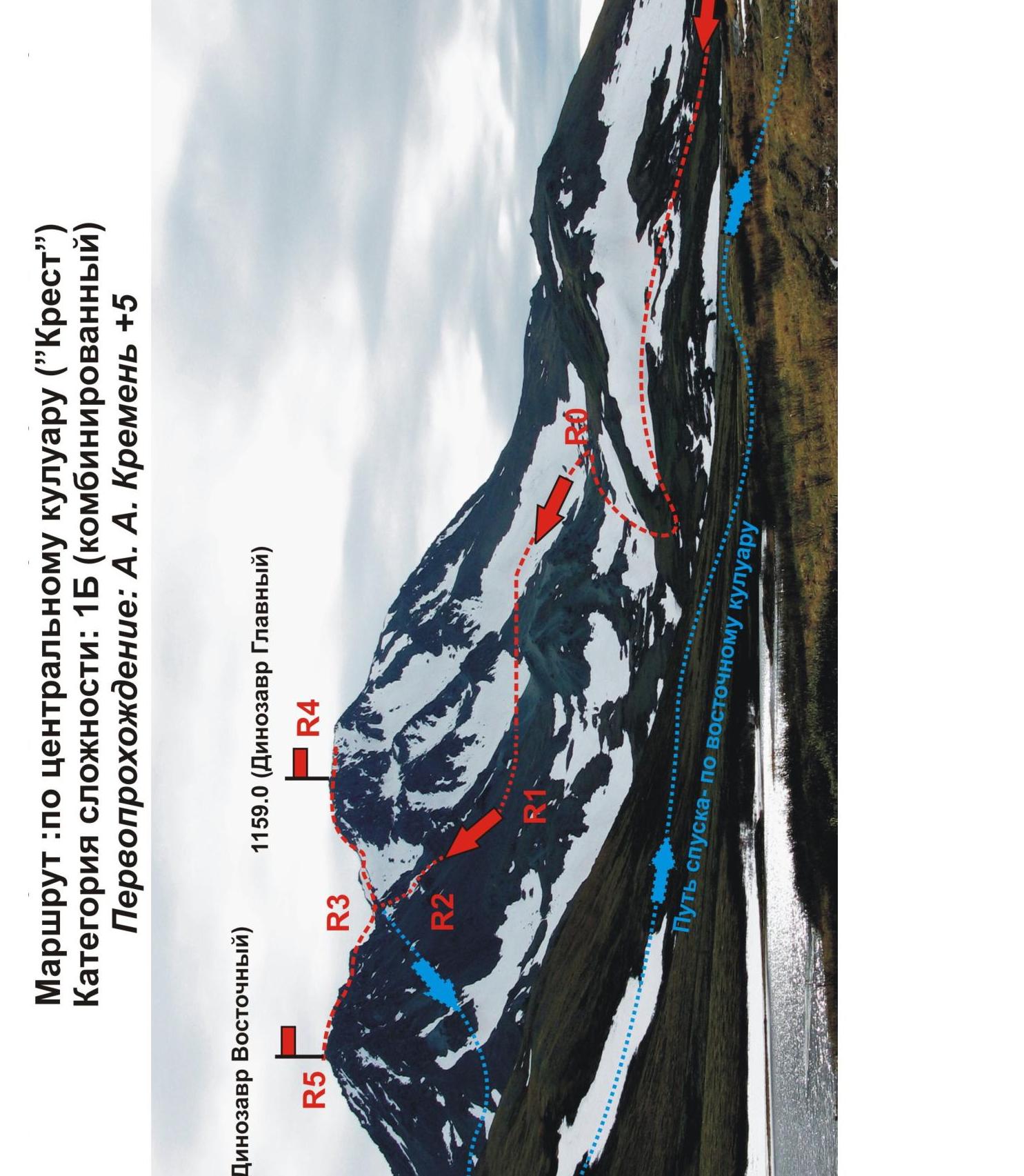
Key section of the route —
"Gorlovina"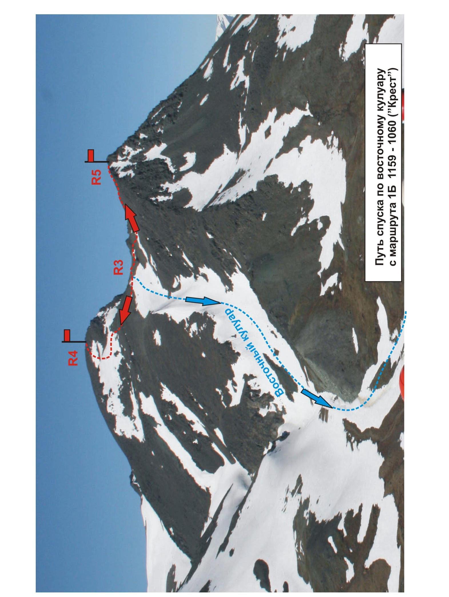
Descent route along the eastern couloir from route 1B 1159–1060 ("Kрест")