8.3.464
Ascent Passport
Mountain region — Polar Urals Mountain range — Rai-Iz massif Gorge — Nyrdvomen-Shor river valley. Section number according to KMGV-2001 – № 8. "Other mountain systems and massifs". Peak name — 1159 (Dinozavr Glavny). Elevation — 1159 m Route name — via the western counterfort of the northern wall of the western ridge. Difficulty category – 3A cat. diff. (approximate) Route type — combined Elevation gain — 950 m (according to the General Staff of the Russian Federation map: initial elevation — 199 m, summit — 1159 m). Route length — 4–5 km, technical sections — 1200 m Technically difficult sections:
- sections of 5th cat. diff. – none,
- 6th cat. diff. – none. Average steepness of the main (technical) part of the route — 55° Average steepness of the entire route — 50° Pitons left on the route — none. Pitons used — 6, chocks — 12. Team's working hours — 12. Group composition:
- leader P. A. Bondaruk (2nd sports category, Syktyvkar)
- Yu. V. Valuzhis (2nd sports category, Syktyvkar)
- I. A. Boyko (2nd sports category, Syktyvkar)
- S. V. Zhuravlev (CMS, Syktyvkar) Departure onto the route — 6:00, June 27, 2007. Reaching the summit — 14:00, June 27, 2007. Return to the base camp — 18:00, July 27, 2007. Organization conducting the alpine event:
- "Alpinistskaya ekspeditsiya 'Rai-Iz' Federatsii alpinizma Respubliki Komi"
- NP "Klub severnykh puteshestviy 'Sauk-Pai'" (Syktyvkar)
- Club of tourists and alpinists of Ukhta
Dates of the alpine event — from June 25 to July 10, 2007.
Senior coach – FARK (Federation of Alpinism of the Republic of Komi) release officer F. N. Fomenko (CMS, 1st category instructor-methodologist, ud. № 07, Ukhta)
Senior coach – release officer of the alpine event S. V. Zhuravlev (CMS, 2nd category instructor-methodologist, ud. № 1124, Syktyvkar)
Federation of Alpinism of the Republic of Komi, Syktyvkar, 2007 year
Peak 1159 (Dinozavr Glavny). Northern wall of the western ridge.

Description of the peak
Peak 1159 (Dinozavr Glavny) is located in the Rai-Iz massif of the Polar Urals, within the Yamalo-Nenets Autonomous Okrug of the Russian Federation beyond the Arctic Circle. A characteristic feature of the routes to this peak is the elevation gain from the start of the route (elevation of the base camp above sea level 199 m) to the summit 1159 m, i.e., a gain of more than 800 m. Another feature of the peaks of the Polar Urals is that the difficulty level increases sequentially from the start of the route to the summit tower. Peak 1159 (Dinozavr Glavny) is included in the list of classified peaks. The first routes to this peak were pioneered by Ukhta alpinists during the winter seasons of 1995–1999. They also gave the peak its alpinist name, as it did not have an official name. From the valley of the Nyrdvomen-Shor stream, the most convenient location for a base camp — a large larch-alder oasis in the tundra — the peak is easily recognizable by its pronounced rock walls and counterforts of the northern and northern walls of the western ridge. The northern wall of the western ridge is characterized by distinctive rock masses with characteristic counterforts, separated by couloirs leading to the western ridge and the pre-summit plateau beneath the rocky- talus tower of the peak.
Couloirs lead to:
- the western ridge
- the pre-summit plateau
- the rocky-talus tower of the peak
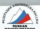
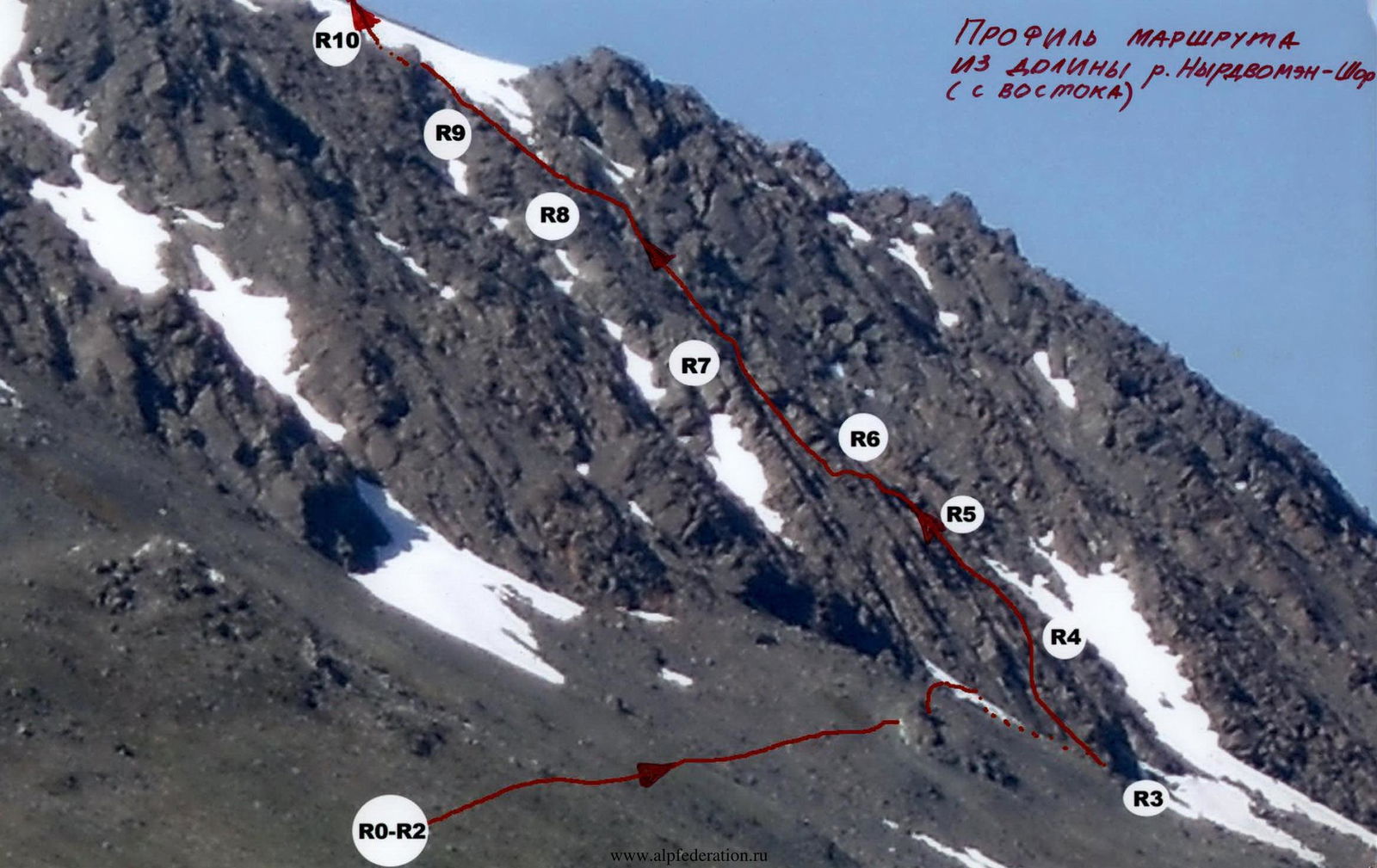
TECHNICAL Photo of the Route from the Nyrdvomen-Shor river valley
ROUTE FINAL Counterfort of the central rock massif
Description of the route
The route: "Via the western counterfort of the northern wall of the western ridge" is clearly visible from the base camp in the Nyrdvomen-Shor river valley. The western counterfort, bounded on both sides by snowy couloirs (which become talus couloirs in the second half of summer), separates the central rock massif of the northern wall of the western ridge from the western rock massif of the northern wall of the western ridge. This is the only counterfort of the western ridge without a false summit, leading to the pre-summit snowy plateau. Approach: Moving from the bivouac in the Nyrdvomen-Shor river valley (see the attached map-scheme), bypass to the right (in the direction of travel) the green bald peak and ascend to a large rock remnant. From it, to the right (in the direction of travel), traverse along the talus slopes, crossing a snowfield, approach the rocky "paw" of the western counterfort of the northern wall of the western ridge. Ascend to the rocky ridge of the counterfort via simple, destroyed rocks to a characteristic stone block "Rhombus". Near the "Rhombus" is a convenient area for organizing a team. This is where the technical part of the route begins. Technical part of the route: It is more convenient to continue the route along the internal angle on the right side of the counterfort. The internal angle leads to the base of an inclined, smoothed rock wall. At the foot of the wall is a rocky ledge allowing for a good base station. This 40 m long wall is the key section of the route. With a steepness of 55°, it is technically challenging due to the need for skills in climbing complicated rock terrain. There are few cracks, holds and footholds are smoothed, and some sections require friction climbing. Further:
- another inclined rock wall (10 m), leading to the ridge,
- a series of small internal angles, 5–10 m each. Climb through the internal angles to beneath a gendarme. Under the gendarme is a convenient ledge with large rock fragments, allowing for a good base station. Bypass the gendarme to the right via a series of oblique ledges to reach the ridge of the counterfort. Further along the ridge — to a sloping wall. Under the wall is a wide, convenient ledge allowing the entire group (three to four people) to assemble. Further:
- an inclined, weakly expressed rock wall. After overcoming the wall, return to the rocky ridge. Further along the ridge, movement is simultaneous, with rope protection around outcrops. In the upper part, the ridge becomes gentler and transitions into a large-block talus. Further:
- along the talus to a snowfield on the western ridge,
- cross the snowfield,
- reach the pre-summit plateau. Then move across the snowy fields of the plateau — to the summit tower. The ascent to the summit from the south — via large-block talus. The summit is well-defined, composed of large blocks. Climbing along the pre-summit ridge is not difficult. On the summit is a triangulation marker. Descent from the summit — safest to the southeast via the descent couloir between peaks 1159 (Dinozavr Glavny) and 1060 (Dinozavr Vostochny). In the summer period, this is a safe, not too steep, prolonged snowy couloir allowing the group to descend with minimal time loss to the geological off-road road. The most challenging section during descent — crossing the upper reaches of Nyrdvomen-Shor via snow bridges, which in summer require organization of protection. Equipment for a sports group of four:
- main rope — 2 pcs. 10 mm × 50 m
- crampons — 4 pairs
- ice axes — 4 pcs.
- ice screws — 2 pcs.
- rock pitons — 10 pcs.
- chocks — 12 pcs.
- station loops — 4 pcs.
- quickdraws — 6 pcs.
- stove (gas burner) — 1 pc.
- pot — 1 pc.
- personal equipment — for each participant.
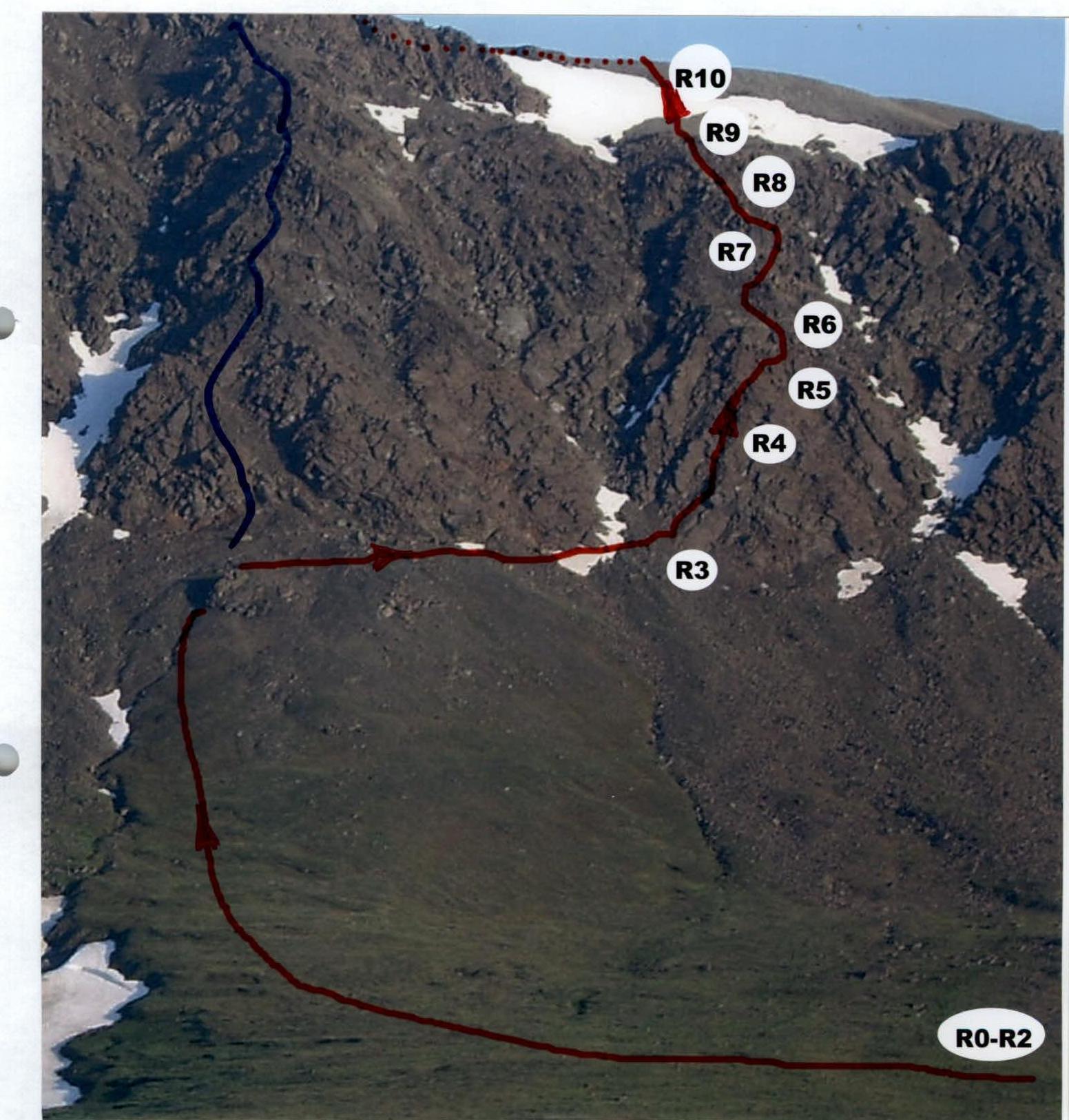
Peak: 1159 (Dinozavr Glavny), route: via the western counterfort of the northern wall of the western ridge
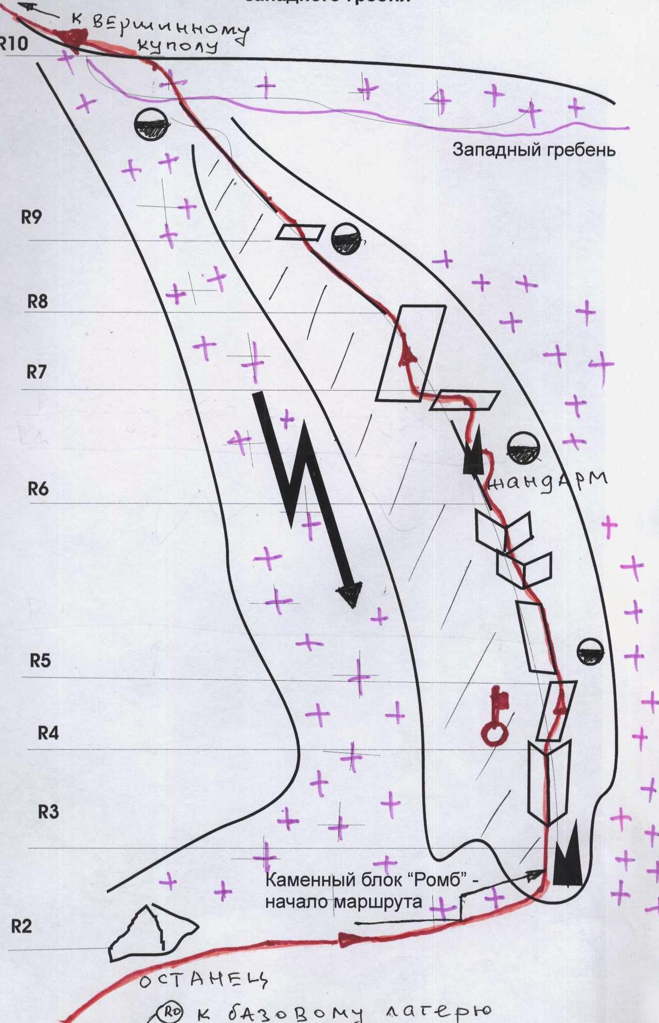
Graphic profile of the technical part of the route indicating the most difficult sections. Scale: 1 cm — 50 m
Profile of the route from the Nyrdvomen-Shor river valley (from the east)
Technical description of the route according to the UIAA signs scheme
R0 — base camp in the larch oasis of the Nyrdvomen-Shor river. R0–R1 — base camp – crossing the Nyrdvomen-Shor river.
- Crossing the Nyrdvomen-Shor river by wading (depth 40–60 cm, during the period of abundant snowmelt, organization of rope protection is required).
- Section length — 500 m.
- Steepness — 10°.
- Difficulty level — non-categorized. R1–R2 — bypassing the green bald peak and approaching the rocky remnant. Mountain tundra, talus. Section length — 2500 m. Section steepness:
- initially 30–45°,
- in the upper part 45–50°. Difficulty level — non-categorized. R2–R3 — traversing talus and snowy slopes, ascending via destroyed rocks to the "Rhombus" stone for team organization. Large-block talus, snow. Section length — 200 m. Section steepness — 45–50°. Difficulty level — 1. Protection during movement across large rock blocks — gymnastic. R3–R4 — passing the internal angle. Rocks. Convenient holds and footholds, abundant cracks and fractures for organizing protection points. Section length — 10 m. Steepness — 55–60°. Difficulty level — 2+. Alternate protection. R4–R5 — passing the key section of the route. Smoothed rocks. Oblique wall with minimal holds, requiring friction climbing. Section length — 30 m. Section steepness — 55–60°. Difficulty level — 3+. Protection:
- Piton and chock protection.
- Quickdraws are mandatory to reduce friction. Organization of passage:
- Alternate movement of participants.
- Organization of rope protection. R5–R6 — passing an inclined wall and reaching the rocky ridge of the counterfort via a series of small internal angles to a characteristic gendarme. Rocks. Section length — 50 m. Section steepness:
- initially — 30°. Difficulty level — 2–, 2+.
- in the upper part — 45°. Difficulty level — 3–. Group movement with alternate protection. Under the gendarme is a convenient ledge for organizing a base station. R6–R7 — bypassing the gendarme and passing the ridge of the counterfort to reach a ledge under an inclined slab. Gendarme is bypassed to the right via a series of inclined ledges. Rocky ridge.
- Section length — 50 m.
- Section steepness — 45°.
- Section difficulty level — 2–, 2+.
- Movement — alternate.
- Organization of intermediate protection points through outcrops, using loops and chocks of various sizes. R7–R8 — passing the inclined slab. Highly destroyed rocks (subjective rockfall danger!). Section length — 20 m. Section steepness — 45°. Difficulty level — 2–, 2+. Movement — alternate. Organization of intermediate protection points through outcrops, using:
- loops
- chocks of various sizes. R8–R9 — passing the rocky ridge to a dividing ledge. (The dividing ledge separates the ridge into two parts. This is a convenient place for organizing a base station). Rocky ridge.
- Length — 30 m.
- Steepness — 45°.
- Difficulty level — 2+, 2–. Protection organization through outcrops, loops on outcrops. Alternate movement. R9–R10 — passing the rocky ridge to reach the snowfield of the snowfield of peak 1159 (Dinozavr Glavny).
UIAA sign scheme of the technically difficult part of the route: "Via the western counterfort of the northern wall of the western ridge"
| Section | Length | Steepness | Difficulty | Pitons | Chocks | Photo № |
|---|---|---|---|---|---|---|
| R10 | ||||||
| R9 | 150 m | 45° | 2–, 2+ | 0 | 24 | № |
| R8 | 30 m | 45° | 2+ | 0 | 0, loops — 5 | № |
| R7 | 20 m | 45° | 2+ | 0 | 5 | №7 |
| R6 | 50 m | 45° | 2+ | 0 | 5, loops — 10 | № |
| R5 | 50 m | 45° | 3– | 0 | 7, loops — 5 | №5 |
| 30° | 2+ | |||||
| Key R4 | 30 m | 60° | 3+ | 2 | 10 | №5, 14 |
| R3 | 10 m | 55° | 2+ | 0 | 2 | № |
| R2 | 200 m | 45–50° | 1 | 0 | 0 | N1, N2 |
Rocky ridge. Length — 150 m. Steepness — 45°. Difficulty level — 2+, 2–. Protection organization through outcrops, loops on outcrops. Alternate movement, in the upper part — simultaneous. R10–R11 — passing the snowy and talus slope, reaching the pre-summit plateau via the western ridge. Snowy, talus slope. Length — 200 m. Steepness — 15°. Difficulty level — n/c, 1–. Simultaneous movement. R11–R12 — reaching the summit dome via large-block talus. Large rock blocks, large-block talus. Length — 150 m. Steepness — 35–40°. Difficulty level — 1–, 1+. Simultaneous movement. R12 — summit 1159 (Dinozavr Glavny). R12–R0 — descent along the center of the eastern slope. Talus, snow. Crossing the Nyrdvomen-Shor river via snow bridges (snow bridges in summer are subjectively dangerous!). Off-road road through the mountain tundra. Section length — 4–5 km. Difficulty level:
- in the upper part — 1–, 1+,
- in the lower part — non-categorized.
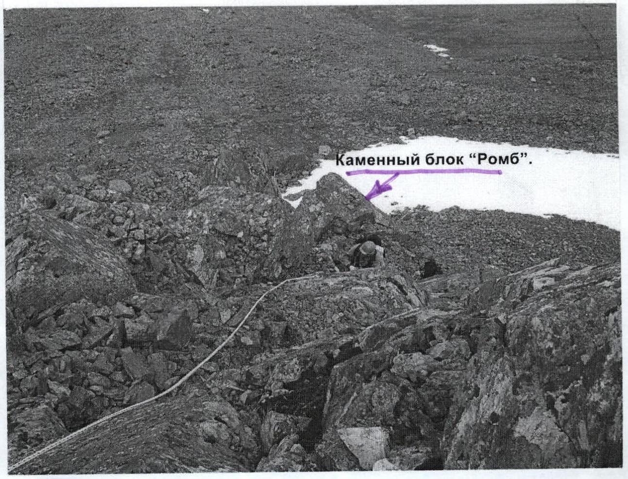
Section R3–R4
Beginning of the technical part of the route from the "Rhombus" stone block
Lower part of the first internal angle
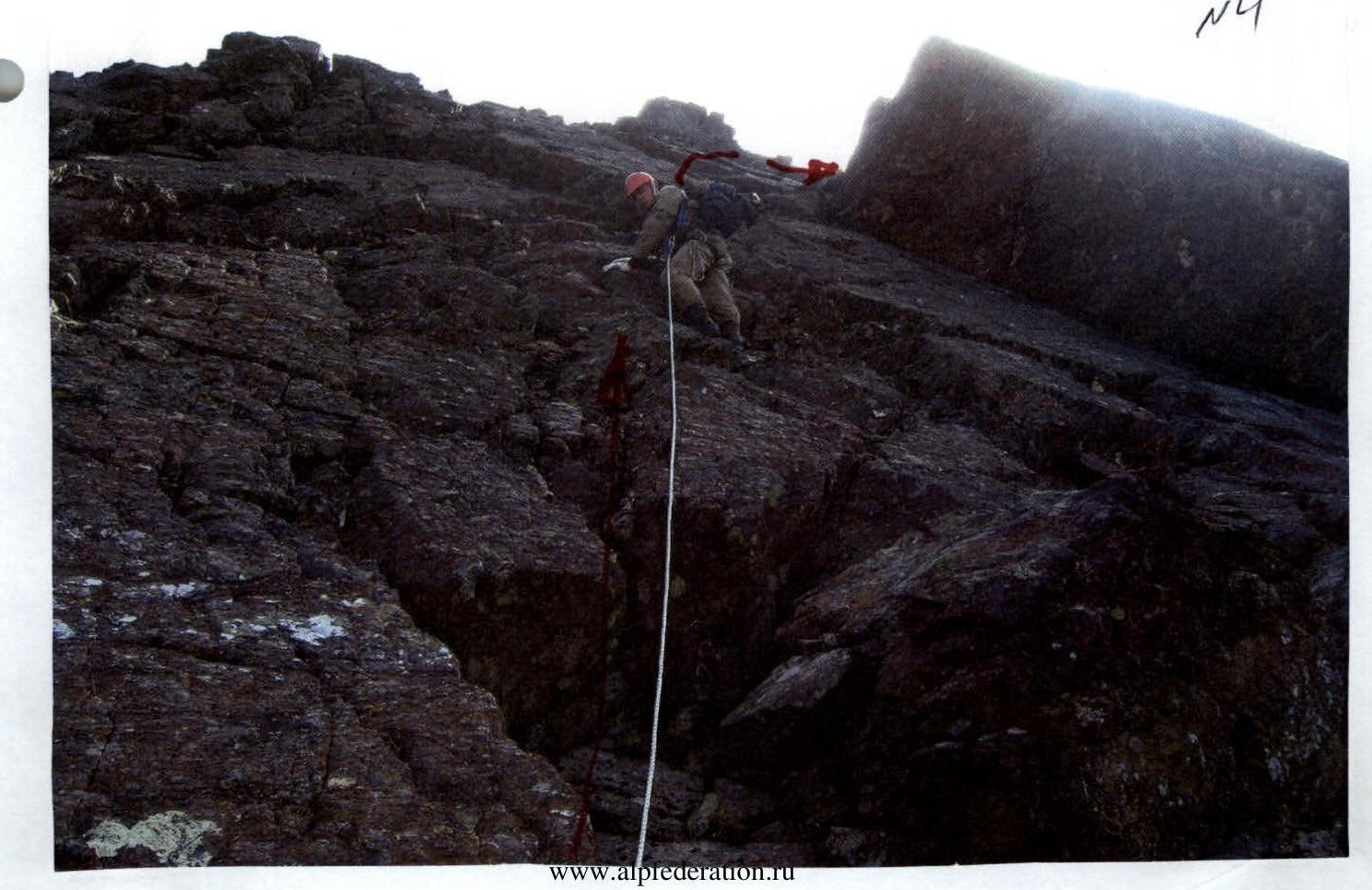
Section R4–R5
Key section of the route — wall with a fracture

Section R4–R5
Section R5–R9

Section R7–R8
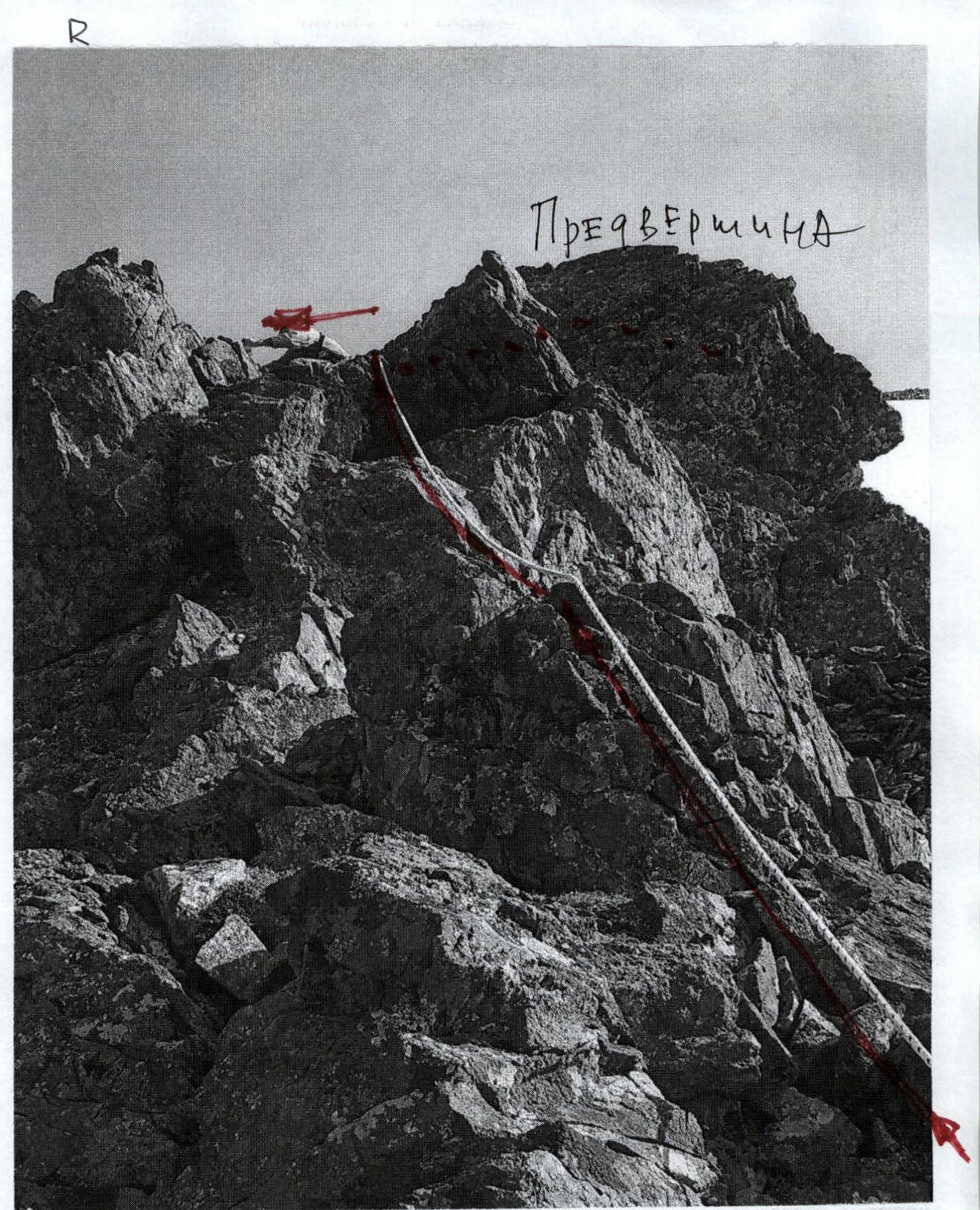
Wall before reaching the snowfield.

Section R10–R11
Passing the talus slope, reaching the pre-summit plateau

N8
- R10
- R11
- R12