
Report
on the ascent to the summit of ACONCAGUA (6962 m) via the north-eastern ridge 4th category of difficulty (original) ("classic") from February 10 to 12, 2009, by a combined team from Moscow and Sumy. Expedition leader: Shatayev V.N. (Master of Sports, Honored Trainer of the USSR)
For all inquiries related to the REPORT, please contact Lavriyenko V.V. (8 916 439-0312)
Passport
11.5.
ACONCAGUA (6962 m)
via the north-eastern ridge, 1897, category of difficulty: 4A
- Class: high-altitude
- Argentina, Andes
- Aconcagua (6962 m), via the north-eastern ridge
- At the discretion of the classification commission (4A original)
- Character of the route: combined
- Height difference: 2610 m
Route length: 5700 m
Average steepness of the route: 30°, length of sections with 5th category of difficulty: 0 m, 6th category of difficulty: 0 m
- Number of pitons left on the route: total — 0; including stationary pitons — 0
Number of pitons used on the route:
- stationary pitons — 0
including artificial points of support (APS) — 0. Total number of APS used — 0
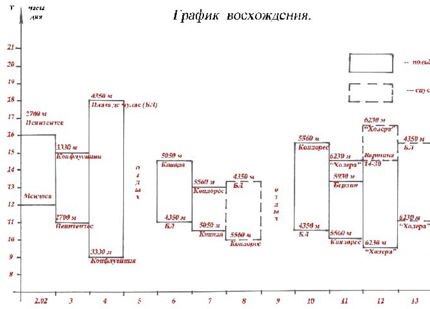
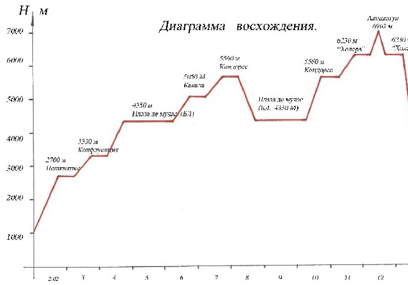
- Team's total travel time: 14.5 hours: 3 (after acclimatization)
- Expedition leader: Shatayev V.N. (Master of Sports)
Team captain: Lavriyenko V.V. (Master of Sports). Team members: 5 people (in addition to the above-mentioned 2)
- Coach: Shatayev V.N. (Master of Sports, Honored Trainer of the USSR)
- Departure for the route: 10:30, February 10, 2009
Summit departure: 14:30, February 12, 2009. Return to base camp: 16:00, February 13, 2009
To the Classification Commission of the Russian Mountaineering Federation
Some explanations regarding the REPORT.
Dear colleagues, although the ascent was made more than a year ago (in February 2009), my friends from the "7 Summits" team, specifically L. Korobeshko, asked me to compile the report. Much has been forgotten, but the photographs taken at the time allowed me to reconstruct the events of those days. Moreover, I was surprised to find that this peak is not included in the new "Classifier". To rectify this, I mentally retraced the entire route with my team members, albeit not on foot, but sitting at my computer. The report is presented in a condensed form, but it is sufficient to evaluate the ascent correctly. I have provided explanations for some omitted sections.
- "Brief overview of the region and the object of the ascent". It seems that if people are planning to go there, they should know that Aconcagua (6962 m) is located in Argentina (not Chile) and is the highest point not only in South America but also in the Western and Southern Hemispheres. It is a fairly high mountain with many routes laid out from various sides. There are challenging routes, as well as easier ones (like the one we took). One should travel there in winter (when it's summer in the Southern Hemisphere).
- "Brief description of the route by sections". The limited number of photographs can clarify the nature of the route. There are no walls or dangerous couloirs. The entire route is traversed on foot with ski poles along a fairly broad slope and then along the ridge. After the last night's bivouac before the summit push, dense snow begins (requiring crampons). For the final meters before the summit, poles can be replaced with an ice axe (for those who are uncertain). The main difficulties of this mountain are its height and potential loss of orientation in bad weather. Unfortunately, many athletes have faced this and were unable to reach the summit. Another crucial factor for a successful ascent is proper acclimatization. As with any "seven-thousander", a gradual, step-by-step acclimatization is recommended. Unstable weather can also present its "surprises".
- "Route diagram in UIAA symbols". There is no particular need for this. Movement is simultaneous throughout. There is no piton protection, and there are no complex or hazardous sections. The main task is to stay within the group and not stray from the route.
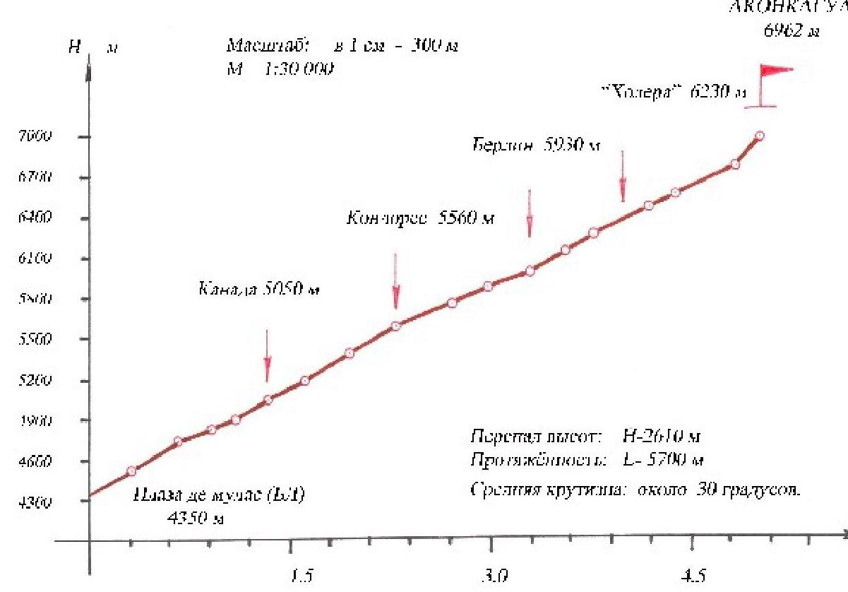
- "Photograph of the route profile". It is technically and practically very challenging to produce. There is a "drawn profile" that provides a clear understanding.
- "Preparation for the ascent". This section is self-explanatory. In my opinion, this point will not be included in the new edition of the "Requirements". Nevertheless, those who train or maintain themselves in shape are the ones who reach the summit. Exceptions are rare.
- "Table of equipment and provisions". Everything is evident from the photo illustrations. Bivouac equipment is the same as for a high mountain. Nutrition follows generally accepted requirements.
- "General photograph of the route" and "Technical photography" were taken from brochures and advertising materials. Special thanks to Vladimir Nikolaevich for the detailed map and technical characteristics of the sections (time taken, height, and steepness).
- "Tactical actions of the team". All actions are based on the nature of the route and the team members. The route is not very challenging. All team members were prepared for what they would face and successfully fulfilled their mission.
- Documentation (registration cards, policies, application, route sheet, etc.) is not attached, as this event was not part of a championship format. Formally, the team included 3 Masters of Sports with instructor categories.
Now, about the main point. The classification of this route. I am presenting my personal viewpoint.
This route is classified as PD (not considered difficult). Yes, that's correct, but besides technical difficulties, routes of this type also present other challenges, such as:
- altitude,
- mountain sickness,
- bad weather,
- loss of orientation, and others.
All these are similar to the "symptoms" encountered when ascending our "seven-thousanders" via the classic route. I understand that this comparison is not entirely accurate (our mountains are, of course, "harsher"), and not so long ago, the Chinese peak Kusumallik was classified as 4B (it's above 7 km). Most likely, this is correct.
Furthermore, all "domestic" high "six-thousanders" such as Izvestia, Abalakov, Leningrad, Marx, Druzhba, Demchenko, Revolyutsiya, 26 BK, K. Zetkin, Gorky, Topografov, and many others are not classified below 5A. Peak "Chetyrekh" is 4A) and Razdelnaya is 3B, and they are all lower than Aconcagua.
To reach Aconcagua from scratch, a minimum of 10 days is required, not to mention getting there. Therefore, it seems to me that it should be classified as 4A. No one will attempt the "fourth category" just for the sake of it; people go there with a different goal in mind.
I reiterate: this is just my personal viewpoint.
In conclusion, I would like to say that whatever verdict the classification commission issues (and the decision will be absolutely correct), the Andes mountains will not "suffer" from it, especially Aconcagua, the first ascent of which was recorded as far back as 1897.
Sincerely: Lavriyenko Vladimir (participant in the ascent)
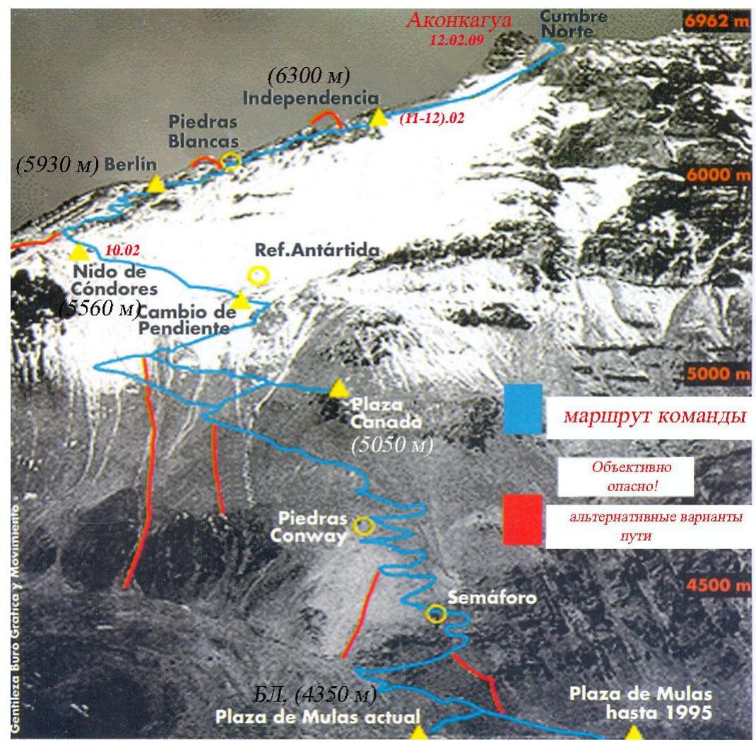
Piedras Blancas (5930 m) Berlin
Table of technical characteristics of route sections:
- Time
- Distance
- Steepness
| Nombre (Name) | Alt (m) | Desnivel Grades (m) | Dist. (km) | Pendiente (%) | Tiempo (ч:мин) | Desnivel acumul. | Dis acum | Tiempo acumul. |
|---|---|---|---|---|---|---|---|---|
| Laguna Hercenes (Hercenes Lagoon) | 2950 | |||||||
| Puente 1 (Bridge 1) | 3070 | 120 | 2.72 | 4.4 % | 0:50 | |||
| Campo Confluencia (Camp Confluencia) | 3390 | 320 | 4.86 | 6.6 % | 1:50 | 440 | 7.58 | 2.45 |
| Piedra Roja (Red Stone) | 3570 | 180 | 3.59 | 5.0 % | 1:20 | |||
| Piedra Ibáñez (Ibáñez Stone) | 3790 | 220 | 7.19 | 3.1 % | 2:25 | |||
| Plaza de Mulas Inferior Low Plaza de Mulas | 4050 | 260 | 4.89 | 5.3 % | 2:00 | |||
| Hotel Plaza de Mulas Plaza de Mulas Hotel | 4370 | 320 | 1.34 | 30.8 % | 1:15 | |||
| Campo Base Plaza de Mulas Base Camp Plaza de Mulas | 4350 | -10 | 1.30 | -1.0 % | 0:20 | 980 | 16.71 | 7:00 |
| PR El Semáforo (0) Semáfino | 4550 | 190 | 0.55 | 29.2 % | 0:45 | |||
| PR Piedras Conway Conway Stones | 4740 | 190 | 0.58 | 27.9 % | 0:50 | |||
| PR Plaza California Plaza California | 4840 | 100 | 0.44 | 22.7 % | 0:30 | |||
| PR Novero – Snow Pass | 4925 | 85 | 0.34 | 25.0 % | 0:25 | |||
| Camp Plaza Canadá Camp Plaza Canadá | 5050 | 125 | 0.45 | 27.8 % | 0:35 | 680 | 3.56 | 3.25 |
| PR Piedra de los 5000 Stone of the 5000 | 5170 | 120 | 0.47 | 25.5 % | 0:35 | |||
| Cambio de Pendiente Change Step Camp | 5370 | 200 | 0.66 | 30.3 % | 1:00 | 320 | 1.13 | 1:35 |
| Camp Nido de Cóndores | 5560 | 190 | 0.54 | 29.7 % | 1:00 | 190 | 0.64 | 1:00 |
| Descanso | 5690 | 130 | 0.75 | 17.3 % | 0:55 | |||
| PR Balcón Amarillo | 5800 | 110 | 0.45 | 24.4 % | 0:45 | |||
| Refugio Berlin Berlin Shelter | 5930 | 130 | 0.59 | 22.0 % | 0:40 | 370 | 1.79 | 2:30 |
| PR Piedras Blancas White Stones | 6060 | 130 | 0.46 | 28.3 % | 0:50 | |||
| PR Piedras Negras Black Stones | 6180 | 120 | 0.39 | 30.8 % | 0:50 | |||
| Camp 3 Falso Filco Camp 3 Falso Filch | 6230 | 50 | 0.31 | 16.1 % | 0:25 | |||
| Refugio Independencia Independencia Shelter | 6370 | 140 | 0.42 | 33.3 % | 1:00 | |||
| PR El Dedo – El Dedo | 6460 | 90 | 0.36 | 25.0 % | 0:40 | |||
| PR La Cueva (Canaleta) The Cave (Canaleta) | 6660 | 200 | 0.83 | 24.1 % | 1:00 | |||
| Salida al Filo Exit to the ridge | 6800 | 140 | 0.23 | 60.9 % | 1:00 | |||
| Cumbre Aconcagua Aconcagua Summit | 6960 | 160 | 0.30 | 54.0 % | 1:30 | 1030 | 3.30 | 8:25 |
| Total Hercenes – Cumbre Total Hercenes – Summit | 4010 | 34.71 | 23.4 % | 26:40 |
| 2.82 | 3 | 4 | 5 | 6 | 7 | 8 | 9 | 10 | 11 | 12 | 13 |
|---|
|
 |
|
 | |
| |
 |
|
 | |
| |
 |
|
 | |
| |
 | | |
:--: | :--: | :--: | :--: | :--: | :--: | Proydennyi marshrut v gruppe Aconcagua (6962 m)
| | |
:--: | :--: | :--: | :--: | :--: | :--: | Proydennyi marshrut v gruppe Aconcagua (6962 m)
Cara Noroeste Northwest Face (severnaya storona)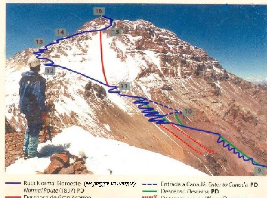
Cara Este East Face (vostochnaya storona)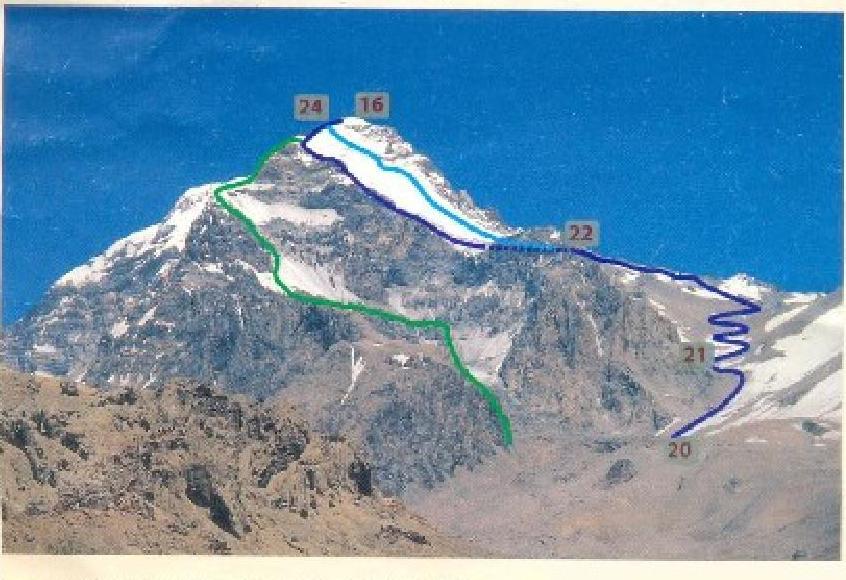
Ruta Eire na de las Policos Puleh Glaciar (1934) AD Ruta Eircsta a Argentina Lineri ltrate or Argentina (1961) AD vysotnyy storony, sitnoznayabьььь (1966) D
Drawn profile of the route.
Comments
Sign in to leave a comment