
Ascent Log
- Category: High-altitude climb
- Garhwal Himalayas, India.
- Bhagirathi III (6454 m) via the center of the West Face, Russian route.
- Proposed grade: 6B cat. diff., first ascent.
- Height difference: 1500 m (wall: 1040 m); distance: 1800 m (wall: 1110 m). Length of sections with 5th cat. diff.: 250 m; 6th cat. diff.: 860 m. Average steepness of the wall: 83°.
- Number of pitons used: ice pitons rock pitons hooked pitons sky-hooks 23 293/210 165/136 57/11 34 Pitons for bivouac organization: 19.
- Team's total climbing hours: 106 and days: 16.
- Bivouacs: 1, 2, 3, 4, 5 all in platform tents.
- Team leader: Potankin Igor Vadimovich MS Saint-Petersburg
Team members:
- K. Vladimir 1st sp. rank Saint-Petersburg
- Lukin Andrey CMS Saint-Petersburg
- Koshelenko Yury IMS Rostov-on-Don
Coaches:
- Odintsov Alexander Nikolaevich IMS Saint-Petersburg
- Pogorelov Alexander Grigorievich IMS Rostov-on-Don
- Departure to the route: September 29, 1998. Summit: October 14, 1998. Return to base camp: October 17, 1998.
- Saint-Petersburg Alpine Federation. Rostov Alpine Federation and Sports.
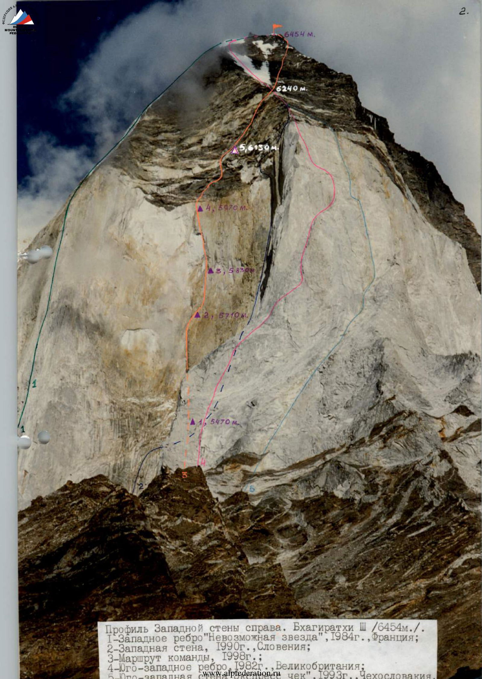
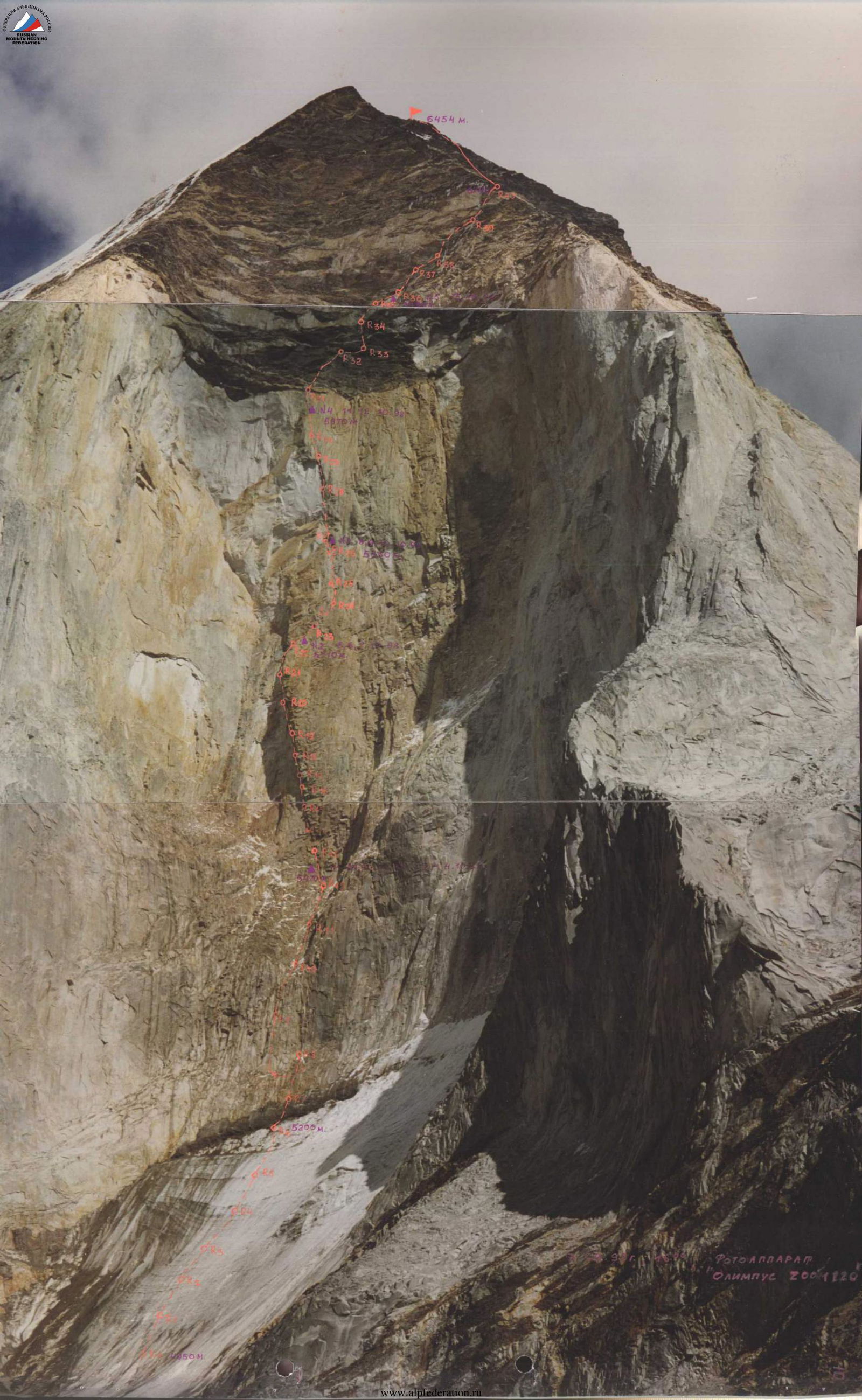
Profile of the West Face on the right. Bhagirathi III (6454 m). 1 — West Ridge "Impossible Star", 1984, France; 2 — West Face, 1990, Slovenia; 3 — Team's route, 1998; 4 — Southwest Ridge, 1982, UK; 5 — Southwest "Express Check", 1993, Czechoslovakia.
Gangotri (Garhwal Himalaya)
Bernard Domenech
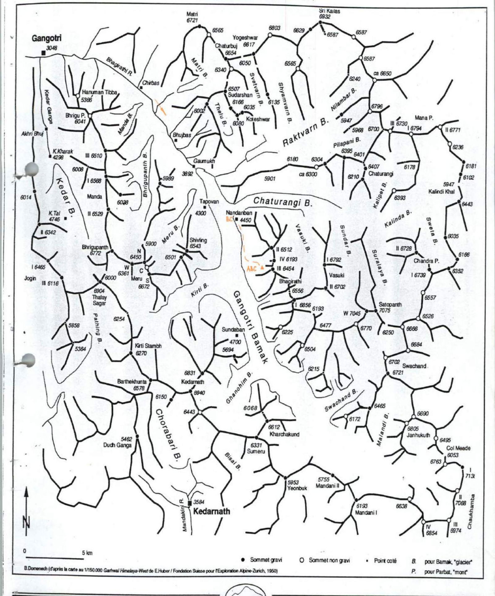
Brief Geographical Overview of the Climbing Area
Object of the first ascent: Bhagirathi III Himalayan peak — the central massif of the Bhagirathi group, consisting of 4 peaks ranked by height: I — 6856 m; II — 6512 m; III — 6454 m; IV — 6193 m. Bhagirathi III stands out from the entire massif with an extensive, sheer, and very complex rock wall 1100 m high.
Since the first ascent in 1933 via the southeast ridge from the south, several technically challenging routes have been established on the peak: 1982 — southwest ridge 1300 m, TD sup (5.8/A2); 1984 — west ridge, "Impossible Star" 1300 m, ED, of which 850 m is 6/A3+, near-vertical; 1990 — west face 1300 m, ED+ 85° 8/A4, climbed by a duo of Slovenian climbers (in our opinion, the route is inaccurately marked in the G.H.M. journal); 1993 — southwest face, "Express Check", 1300 m TD sup.
Recently, the southwest ridge and "Impossible Star" routes have become the most popular. In the spring of 1998, a team of French climbers attempted to make a first ascent via the right part of the west face but were stopped by bad weather.
The Bhagirathi region is the source of the Ganges. The place where the Ganges emerges from the glacier is called Gaumukh, and the Ganges itself is called Bhagirathi until it reaches the plains. The settlement of Gangotri, like Gaumukh, is a pilgrimage site, so the roads and trails are generally kept in good condition.
However, in the event of heavy rainfall, all communications are subject to severe avalanche and mudslide attacks, so one must be prepared for the road and trail to be blocked in many places.
Typically, climbers travel from Delhi to the small mountain town of Uttarkashi, Uttarakhand state. From Uttarkashi to Gangotri is 100 km, and if the road is in good condition, it takes 1 day by car. In Uttarkashi, there are several firms that provide expedition services, including porters and camping equipment. From Gangotri, it takes 2 days of trekking to reach the "Nandanvan" base camp, from which ascents are made to all peaks of the Bhagirathi group. To climb, one must obtain a permit from the Indian Alpine Federation in advance and pay a fee.
Tactical and Technical Actions of the Team
Initially, the tactical plan, like last year on the Tolley Wall, involved two ascents by two teams via two different routes. Moreover, both lines were to be new on the West Face of Bhagirathi III. One of the main ideas of the national program "Russian Path — Walls of the World" is to climb the greatest walls with new routes, if possible, with maximum complexity for each specific object of ascent. The center of the West Face fully corresponded to this requirement. When viewing the planned line through binoculars, it was breathtaking due to the steepness and complexity of the terrain. The complexity was no less than on Troll, and possibly even higher, all between 5000 m and 6500 m.
The tactical plan of the expedition was developed based on the results of reconnaissance carried out by A. Odintsov and I. Potankin in May 1998. The trio of A. Odintsov, I. Potankin, and Yu. Koshelenko was to focus on the center of the West Face. The duo of A. Lukin and V. Kachkov — on its left part, to the left of the "Impossible Star". On September 6, 1998, the first 6 ropes were hung on ice to the bergschrund, directly to the center of the West Face. After that, a long period of snowy storms began, during which several attempts were made to climb the wall, but without success. All attempts to advance further ended in digging out the ropes and equipment left above, buried in compacted avalanche snow. Trenches as tall as a person and tens of meters long became our usual work for a long time.
On September 21, 1998, taking advantage of a short break in the storms, under extreme avalanche conditions, we managed to hang two and a half ropes above the bergschrund. Then followed a week of bad weather, digging out ropes, and other "snowy entertainment". During this time, a decision was made to abandon the original plan and combine the efforts of both groups on one — namely, the central — route. Since the permit for the ascent expired on September 30, we decided to storm the wall regardless of the weather. This was facilitated by the overhanging nature of the wall, starting from the inner angle, which is the boundary of the left part of the huge rock massif in the lower part of the wall, named by us "the belly". On September 27, 1998, 4 more ropes were hung under the safe overhang of "the belly". On September 28 and 29, working in two autonomous duos, the team went into isolation.
The mountain was in a winter state, October was approaching, and daylight hours were as short as in February. The air temperature in the tent in the morning was: –7°C — –10°C; closer to 6000 m, it was down to –20°C with wind on the open terrain. In reality, the complexity of the chosen route turned out to be much higher than expected. The weather until October 4 was extremely unstable: at night, in the morning, in the evening, and often throughout the day, it snowed heavily. We climbed under the cover of "the belly". The average pace of movement was one to one and a half ropes per day, due to extreme conditions, extreme state, and the complexity of the route. This was the maximum speed that could be maintained while ensuring the necessary degree of reliability characteristic of A3–A4. We did not see the sun until we emerged from under "the belly", around camp 3 it appeared after 15:00, and around camp 4 — after 13:30. The constant negative slope forced us to work from the center of gravity, which greatly increased the number of necessary points, except for those extreme sections that we managed to climb using free climbing. A. Odintsov was unable to continue the ascent due to illness, so the team consisted of 4 people. The lead climber's work was distributed as follows: R0–R10, R16–R19, R20–R23, R26–R29, R35–R36, R42–R43 — Koshelenko Yu.; R10–R12, R15–R16, R23–R25, R29–R32, R36–R42 — Kachkov V.; R12–R15, R18–R21, R25–R26, R32–R35 — Potankin I.; start on R25–R26 — Lukin A.
Characteristic landmarks of the route included: the huge formation in the center of the wall — "the belly"; the "seven" overhang or simply "the poker"; on the black tower — the "right eye" overhang, and a huge inclined inner angle under the overhanging wall — "the fault", leading to the southwest ridge. The line was planned at the junction of two walls: the right, older part, and the left, more recent part, as far left as possible from the Slovenian route, which, according to the description in G.H.M., should pass through the center of the wall.
In the upper part, 200–250 meters to the right of our line, at the beginning of the black belt above the overhang, a rope hangs, irregularly shaped, heading to the right towards the ridge, practically along the border between the black and light rocks. Since no more information about ascents on the West Face has appeared, it was natural to identify it as the Slovenian route. On the way to "the fault" and in "the fault" itself (a natural exit from the wall), no traces of climbers were found. The Slovenian line in G.H.M. is not marked along "the fault" but along an overhanging section of destroyed rocks above "the fault", which is absurd to climb. From this, it can be concluded that the Slovenian route does not pass through the center but through the right, more gentle and simpler part of the wall, and its line in G.H.M. is too rough to match reality.
To overcome the wall's complexity, the team used: free climbing, climbing on artificial holds (I.T.O.), and mixed climbing. Some sections were climbed in rock shoes despite the strong frost. Technical means included: a set of camalots, "Strego" friends, sky-hooks for holes and terrain, axe-pitons, two sets of chockstones, 8, 10, 12 mm pitons, 3 dynamic ropes UIAA, 2 of 55 meters, and one 50 m, two "MARKILL-STORMY" gas stoves, and two hanging platform tents.
The lead climber worked on a double rope. Ascent and descent on the fixed ropes were done with backup protection. High-quality protection was mainly ensured by organizing reliable protection stations on good rock pitons and pitons, using modern equipment like camalots, and dynamic ropes "MAMMUT" and "BLACK Diamond" with a low impact force. Typically, there were several points on a rope that could withstand a serious fall. Up to the black tower, the rock is very solid, and it took up to 15–20 minutes to place 10 and 12 mm pitons. To climb the overhanging black tower, mostly composed of shale, very long titanium pitons, duralumin "carrots", and 12 mm "SPIT Petzl" pitons were specially taken. On the destroyed shale, the only reliable footholds were the stations, which had to be organized by finding inclusions of sufficiently solid rock. There was practically no trust in any other points.
Communication with the base was maintained on an ALAN-95+ VHF radio station. The base radio station was equipped with a high duralumin antenna on guy wires.
On October 14, 1998, at 12:30, the group reached the summit of Bhagirathi III and descended to storm camp No. 5 on the same day. The descent from the wall followed the ascent route as planned. During the descent, all trash left during the ascent was removed from the bivouac sites. The descent occurred under severe weather conditions: on the night of October 14-15, a strong wind arose, and it snowed; on October 16, the wind strengthened to storm force, and the lower part of the wall was especially dangerous due to avalanches. Snow fell in thick curtains. On October 17, we managed to make a transition to the "Nandanvan" base during a real storm, and the last 3–4 km of the flat section were traversed on fresh snow, exclusively by crawling. It took 14 hours to reach the base camp, compared to 1.5–2 hours under normal conditions. The ascent and descent were completed without falls, injuries, or serious frostbite.
All expedition members were insured by the Rossno company, under a special tariff for climbers and rock climbers. The insurance could easily cover the costs of emergency helicopter evacuation.
At the base camp, there was a doctor with a well-stocked first-aid kit.
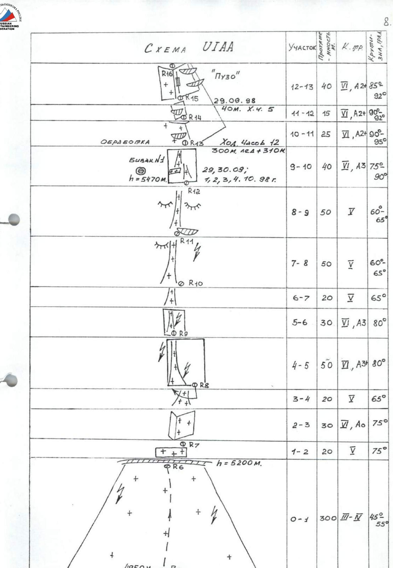
Route Description by Sections
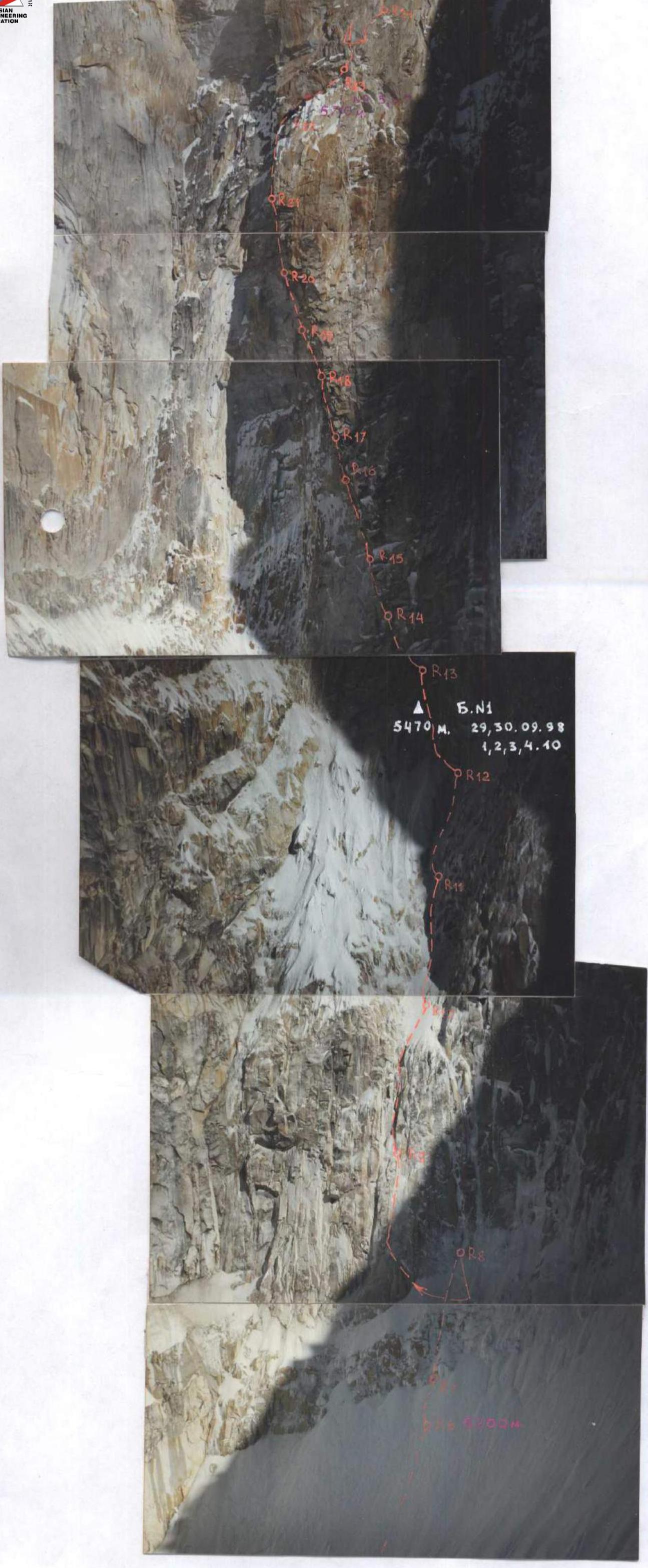
R0–R1 300 m ice-snow slope, 45°–55° steep. Climbed with alternating protection through ice screws. After the bad weather period from 7.09. to 17.09.1998, it was almost entirely firn.
R1–R2 Steep ice wall with embedded rock debris. Crampons, ice axe. Protection through ice screws.
R2–R3 Snow-covered rock wall. Thin crust of ice. Protection through pitons. Climbed using ice axe and crampons.
R3–R4 Ice under a thin layer of snow. Crampons, ice tool.
R4–R5 Very fragile, thin layer of unstable ice on "ram's foreheads". In case of a fall — a 25–30 m pendulum. Virtually no suitable protection points. Area is heavily hit by ice and rocks, especially after 15:00.
R5–R6 Very fragile ice "brook". Searching for protection points is difficult. Powder avalanches.
R6–R7 More gentle ice "brook". Crampons, ice tool. Movement closer to the right edge. Under the cover of an overhang.
R7–R8 Ice "brook" among "ram's foreheads". Protection through ice screws. In bad weather, heavily hit by avalanches coming from the right part of the wall.
R8–R9 Ice "brook". In its upper part, it is under the cover of an overhang. A safer place than before. Protection through ice screws.
R9–R10 Destroyed wall, covered with a very thin and fragile layer of ice. Problems with organizing protection. Pitons are unreliable. Station on a piton and a piton hook.
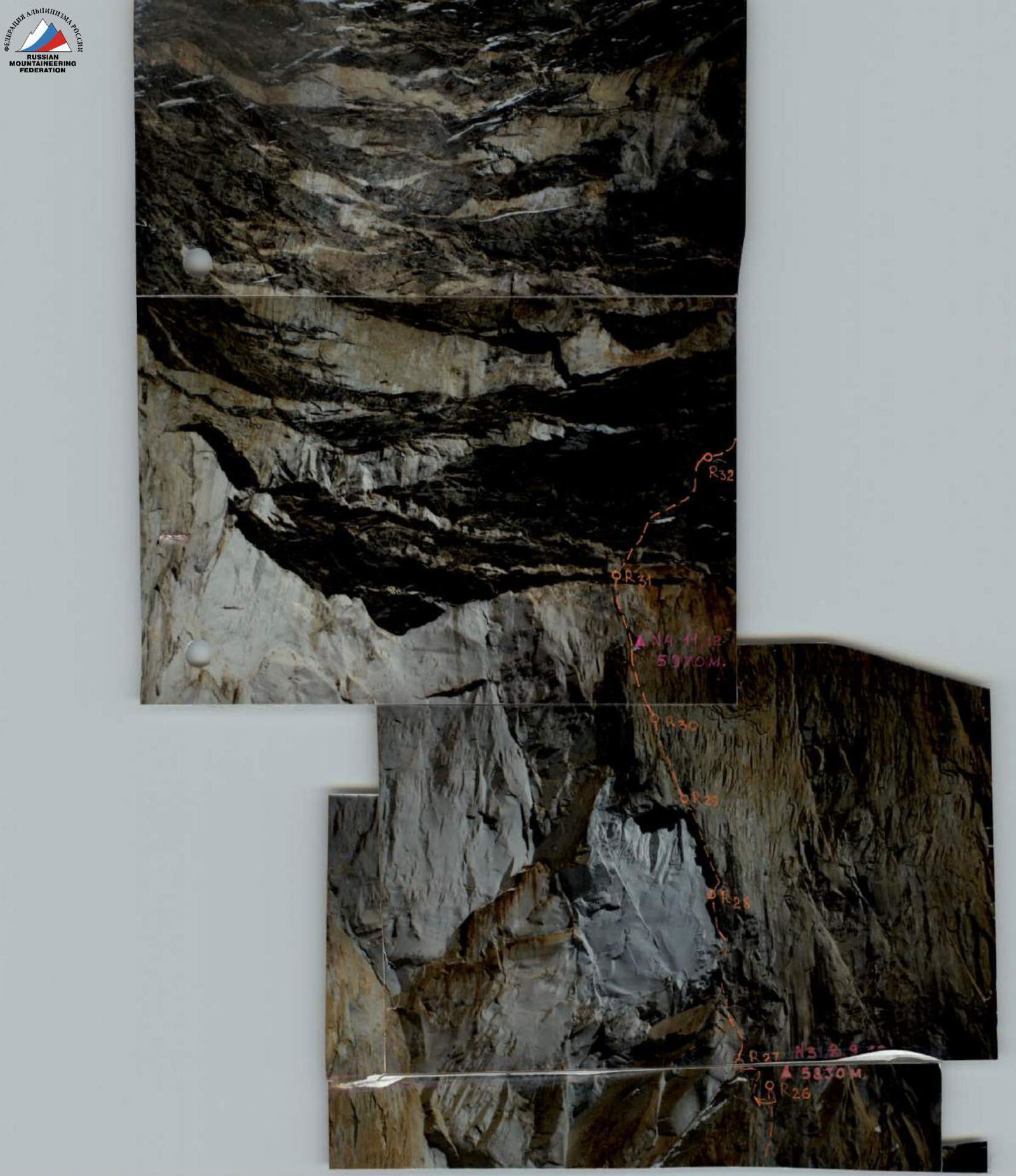
R10–R11 Dissected, overhanging rocks of the lower part of "the belly". Complex and accurate climbing. I.T.O.
R11–R12 Beginning of a huge, overhanging inner corner on the right. Left edge of "the belly". I.T.O. Searching for suitable points is difficult.
R12–R13 Overhanging inner corner. For I.T.O., often have to climb onto the overhanging right wall.
R13–R14 Complex I.T.O., heavily destroyed rocks. Many "live" stones. Station on the overhanging right monolithic wall of "the belly".
R14–R15 Climbing along the corner. On the left, huge, detached "live" blocks. I.T.O.
R15–R16 Very complex passage under the overhang using sky-hooks, beginning of a heavily destroyed overhang. Station on the overhanging right wall.
R16–R17 First stage of the heavily destroyed overhang, consisting of several cascades. Very dangerous climbing, mainly on friends and camalots.
R17–R18 Second stage of the overhang. The terrain becomes more reliable. Climbed mainly on chockstones. I.T.O.
R18–R19 Heavily snow-covered, destroyed rocks. Exit up a sheer wall onto a steep snow "ledge". Piton. Climbing in crampons.
R19–R20 The "ledge" is a series of steps of "live" blocks stuck together, with snow stuck to them. The wall casts a shadow. Hanging station at the end of the "ledge".
R20–R21 Movement upward to the right, then a pendulum to the right. Under an overhang. Complex I.T.O. using sky-hooks on the terrain.
R21–R22 Overhanging crevice. Climbed on I.T.O. Heavily snow-covered in the upper part. Sky-hooks. Station on piton hooks.
R22–R23 Slab without terrain, turning into very unreliable crevices. Sky-hooks. I.T.O. on barely holding pitons.
R23–R24 Sections of extreme free climbing in rock shoes in –15°C frost, mixed with I.T.O. on overhangs, very inconvenient for placing points.
R24–R25 Through an overhang to the left onto a slab and then onto a small snow-covered "ledge".
R25–R26 Extreme climbing on sky-hooks through holes, terrain, and thin, unreliable cracks, with frequent changes in direction. The wall overhangs significantly. Protection through piton hooks.
R26–R27 Transition from a very bad crack "piton on pull-out" to a wider camalot crevice, through an overhang — exit onto a "ledge".
R27–R28 Very dangerous climbing on "live", detached blocks and "feathers" under an overhang — in the shape of a "7". Only 2–3 reliable points. The wall overhangs.
R28–R29 The "seven" overhang is climbed head-on on an axe-piton in a deep crevice and barely holding camalots placed in the unevenness of the layers forming the overhang. Pitons at the exit from under the overhang are unreliable and float even under body weight. After the overhang, a piton hook.
R29–R30 Sheer inner corner with a good crevice for standard pitons. I.T.O.
R30–R31 Sections of I.T.O. and free climbing on fairly solid monolithic rocks.
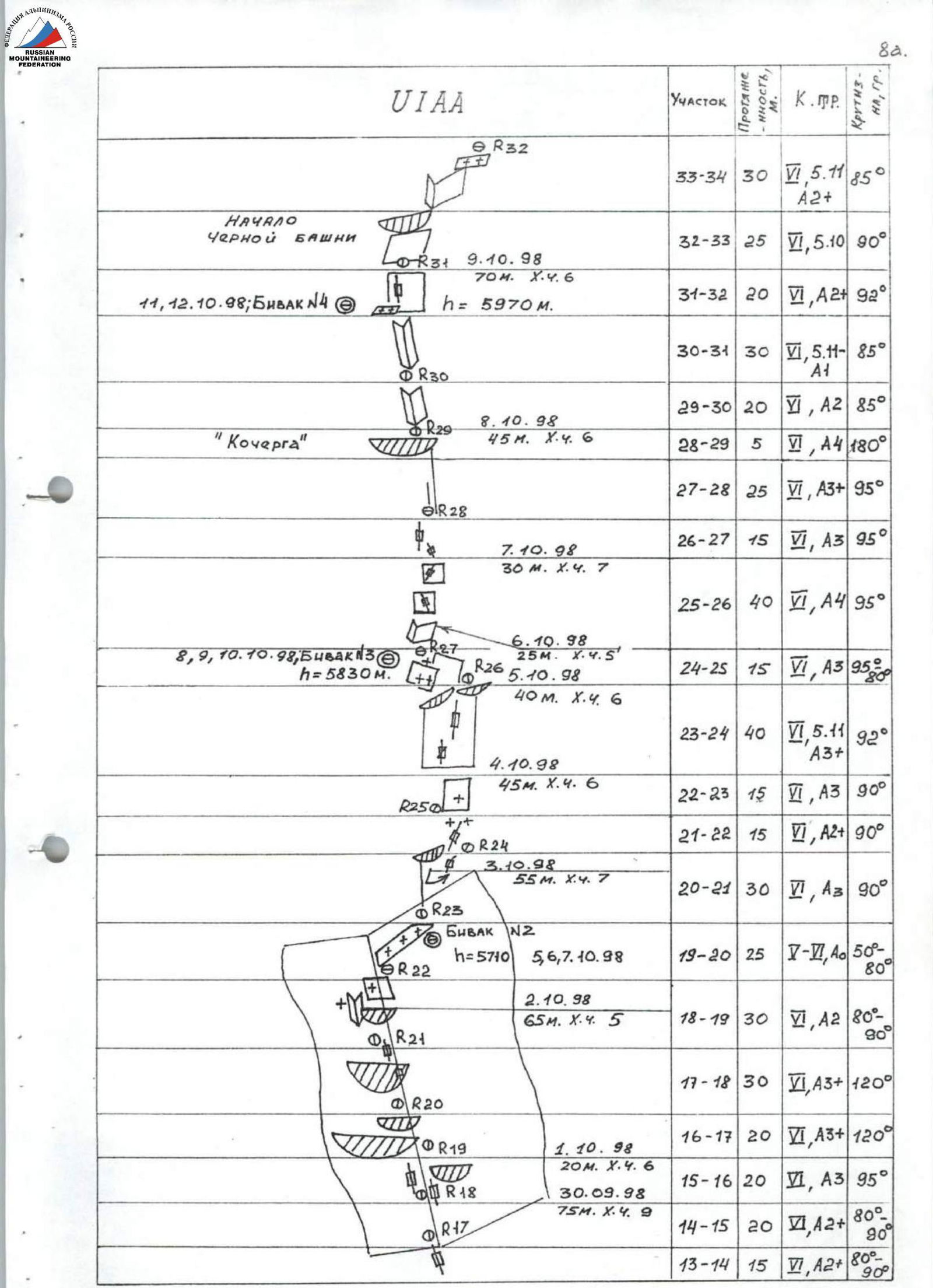
R31–R32 Sheer wall with a very thin crevice for pitons. I.T.O.
R32–R33 Beginning of the black shale belt. All in destroyed overhangs. Very rotten rocks. Nothing reliable. Free climbing in rock shoes. Strong frost. Protection through 12 mm piton hooks.
R33–R34 Climbing under an overhang with a general direction upward to the right. Rocks are destroyed to the state of sand in some places. Protection through 12 mm piton hooks.
R34–R35 Free climbing under an overhang upward to the right and I.T.O. head-on through overhangs. Station on a piton and a 12 mm piton hook.
R35–R36 Heavily destroyed, overhanging section, consisting of a cascade of small overhangs. No confidence even in 12 mm piton hooks. All is "live"; rocks are as if eaten away by acid. Salt stings the eyes. Very dangerous I.T.O. Station on more or less reliable rocks.
R36–R37 Overhanging crevices. Exit onto I.T.O. to the edge of the destroyed belt, leading to the southwest ridge of a large inner corner.
R37–R38 Climbing that initially seemed not very complex turned out to be quite serious. Very destroyed terrain, few suitable places for protection. Holds are unreliable.
R38–R39 Climbing along the corner. Snow-covered steep slabs alternate with very rotten formations. Requires maximum concentration and strength. Problems with finding suitable protection points.
R39–R40 Slabs lightly covered with snow. Accurate climbing. Protection — camalots.
R40–R41 Overhanging section with hanging icicles. Rocks are heavily destroyed. Complex I.T.O. and free climbing.
R41–R42 Section with more or less monolithic rocks. General direction upward to the right. Exit onto the southwest ridge. Station on piton hooks.
R42–R43 350–400 m along snow-covered rocks, ice to the right onto a destroyed counterfort falling directly from the summit, and along it to the snowy white summit of Bhagirathi III, crowned with a huge overhang. Movement in pairs of 2, simultaneous, protection — ice screws, friends, pitons.
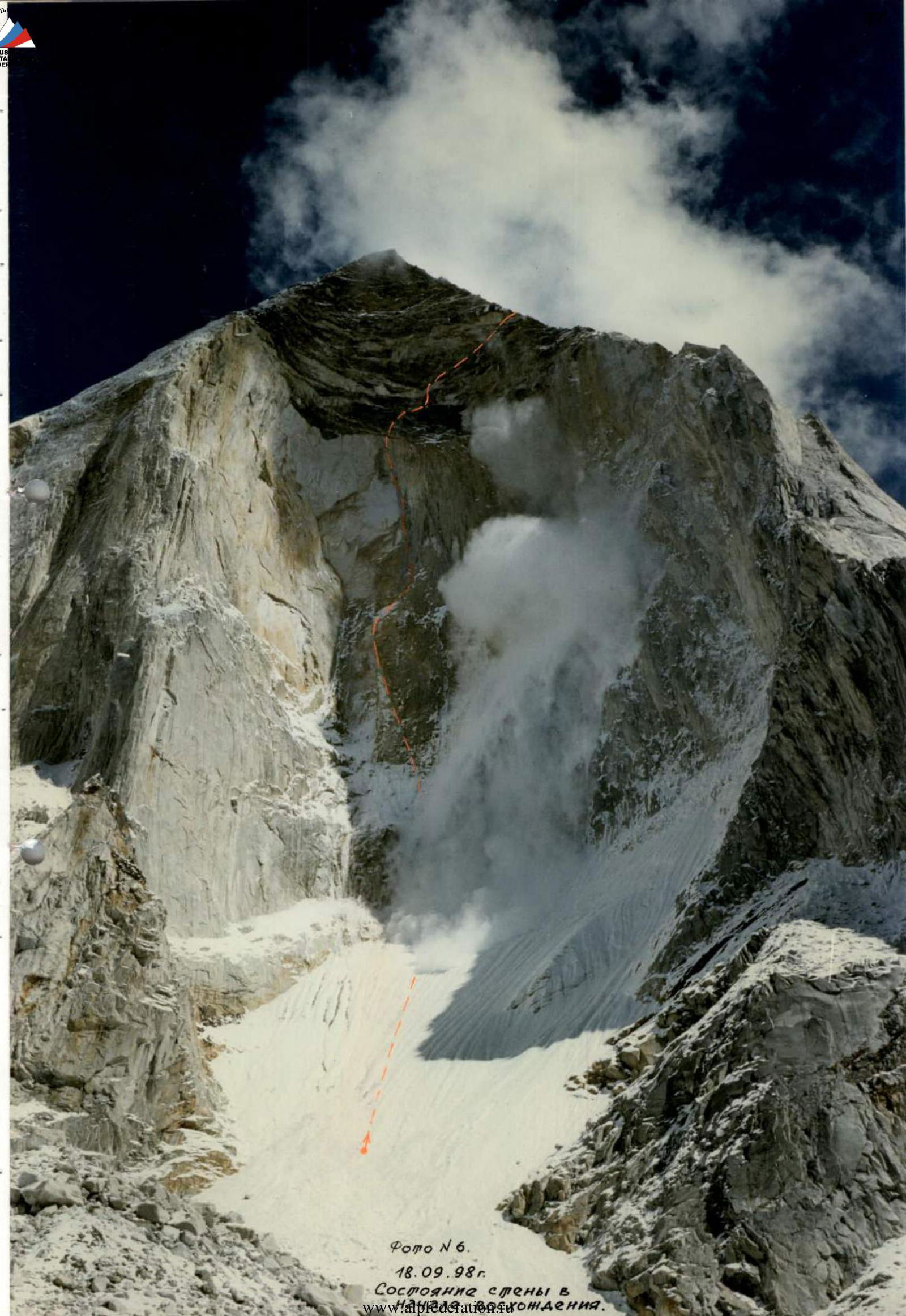
Photo #6. September 18, 1998. State of the wall during the ascent.
Olympus camera.
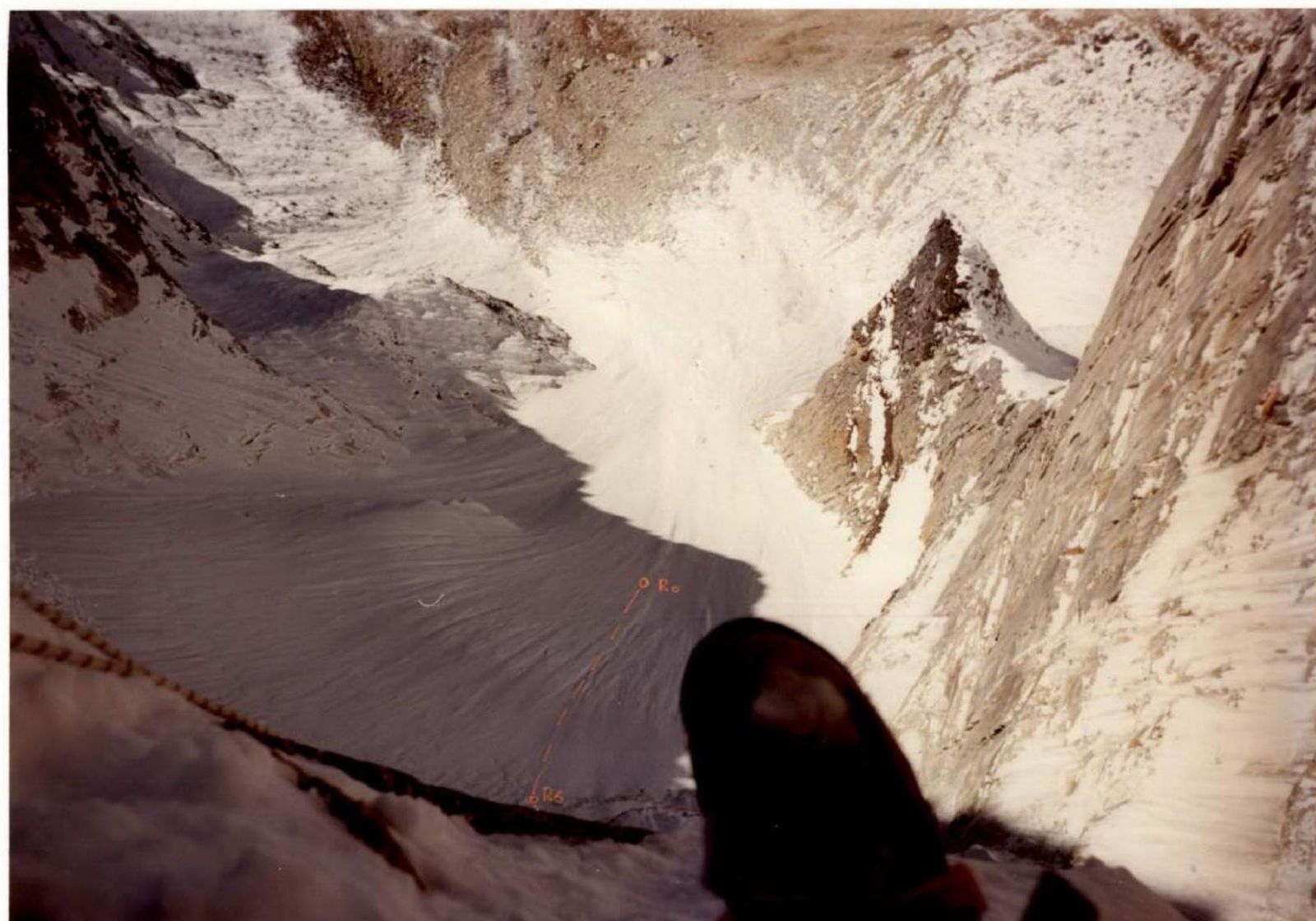
Photo #7. October 5, 1998. 13:00. Sections below bivouac #1.
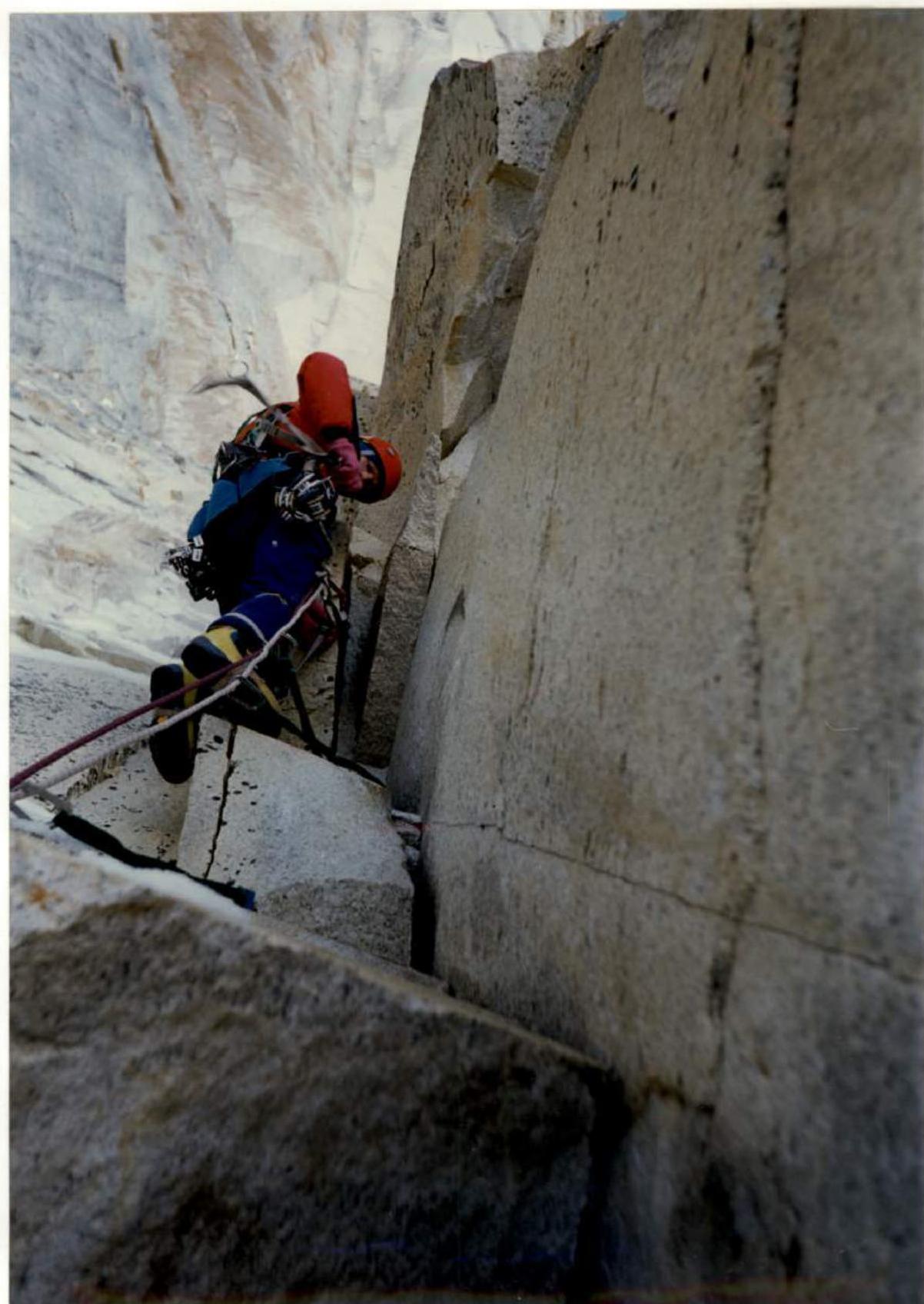
Photo #9. September 30, 1998. 11:00. Section R12–R13.
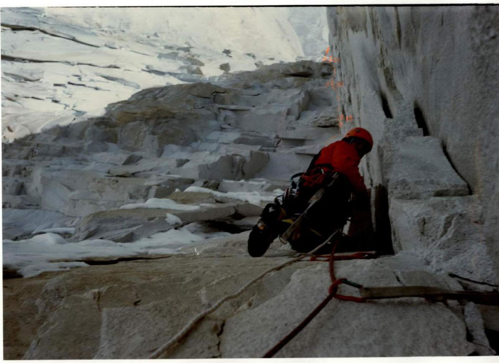
Photo #10. September 30, 1998. 17:00. Sections R14–R18.

Photo #11. October 7, 1998. 7:30. Bivouac #2.
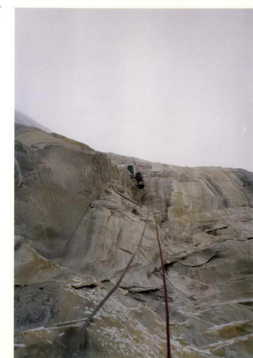
Photo #12. October 15, 1998. 15:00. Section R22–R24.
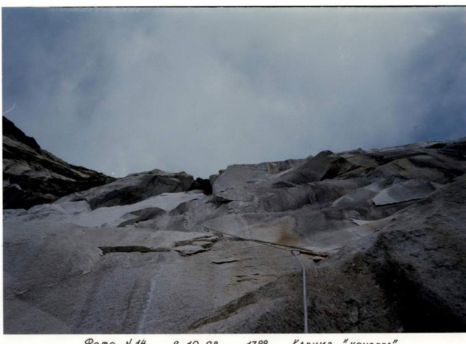
Photo #14. October 8, 1998. 17:00. "Poker" overhang. Sections R25–R29.
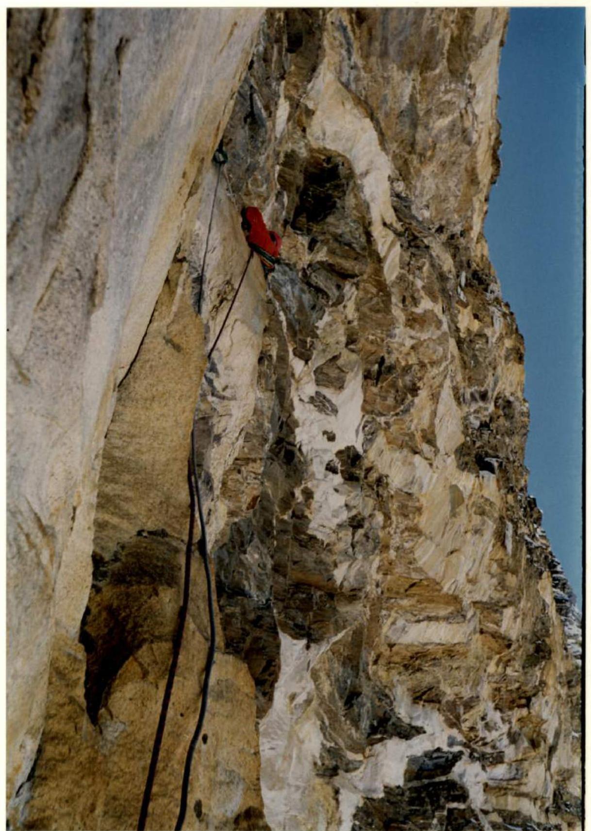
Photo #17. October 10, 1998. 11:30. Section R32–R33.
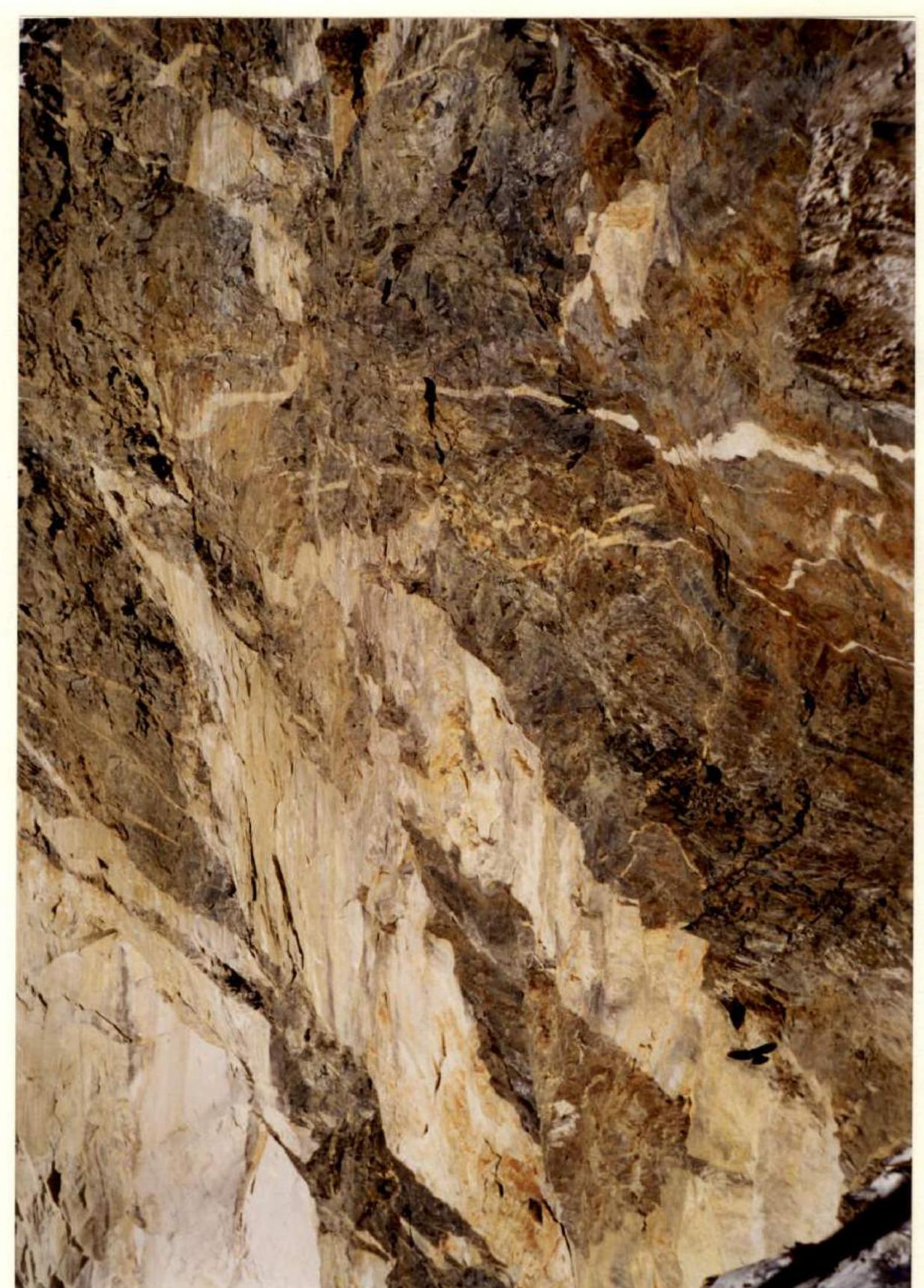
Photo #18. October 12, 1998. 15:00. "Black tower". Profile.
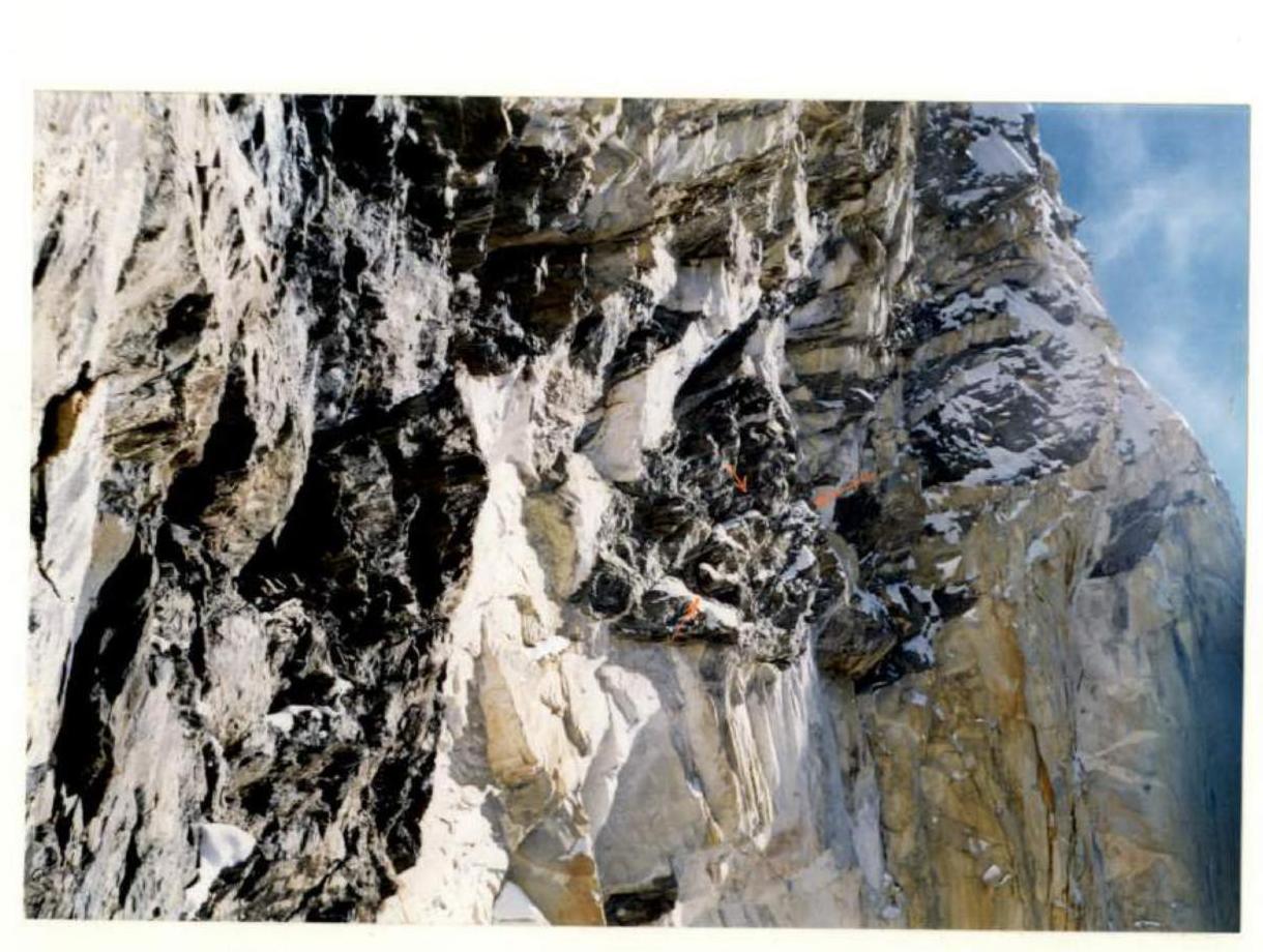
Photo #21. October 10, 1998. 16:00. Fixed rope. In our opinion — Slovenian.
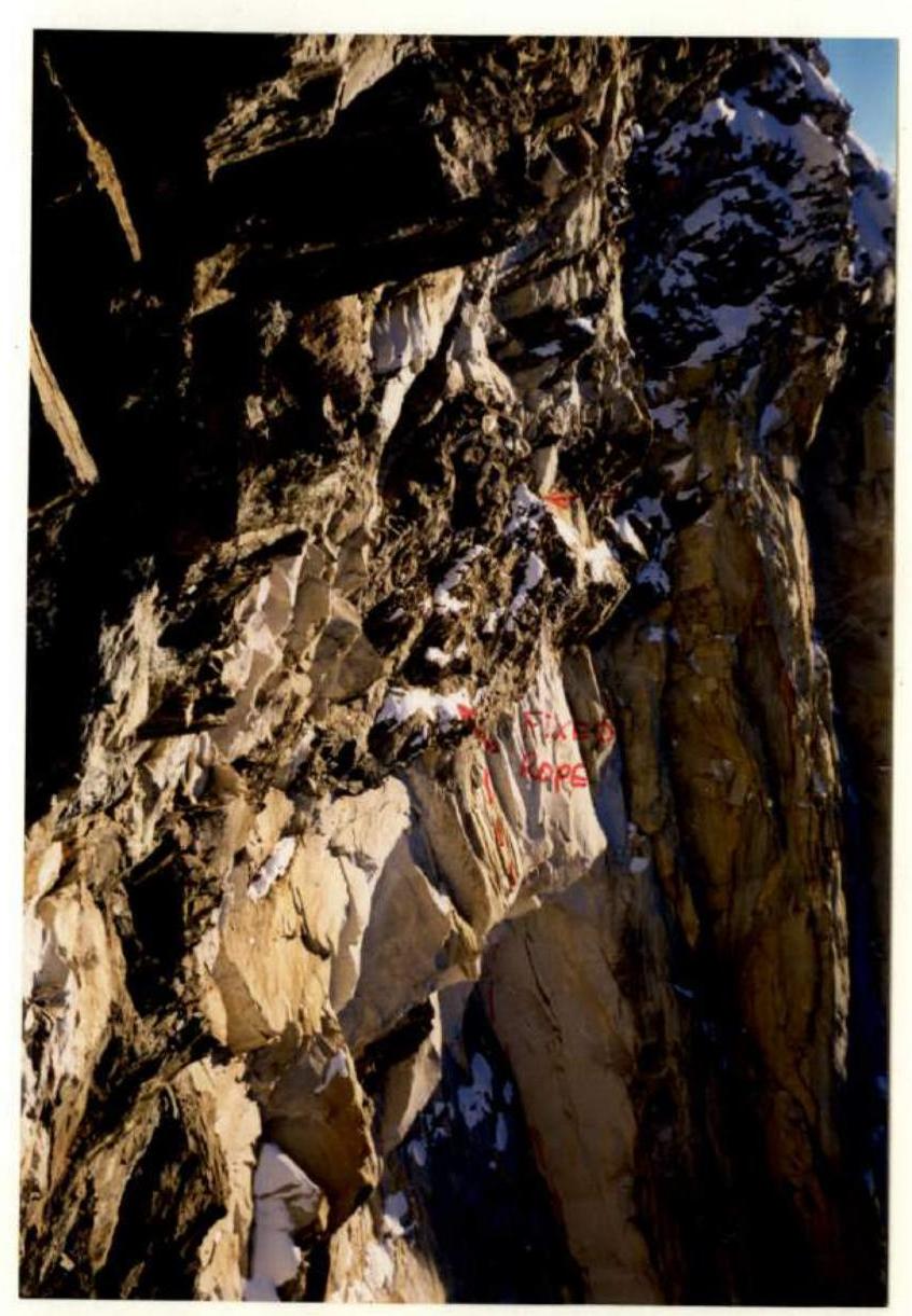
Photo #22. October 12, 1998. 17:30.
Photo #23. October 11, 1998. 12:30. Section R35–R36.
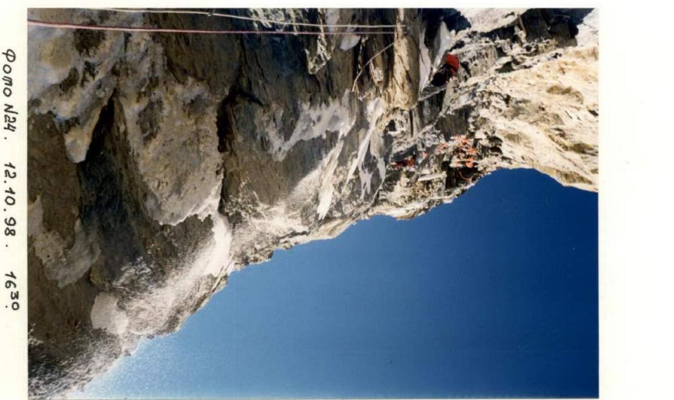
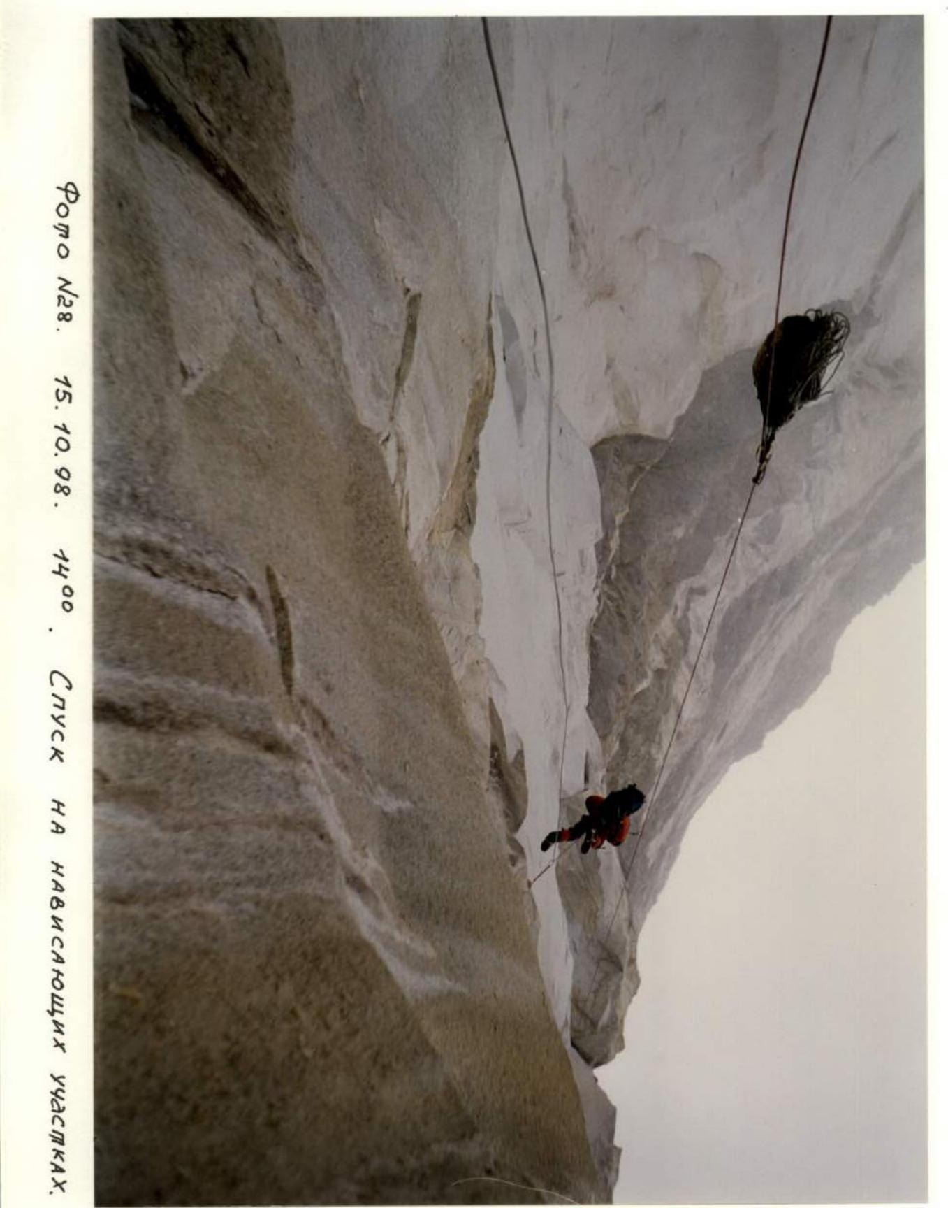
Photo #24. October 12, 1998. 16:30. Sections R37–R39.
Photo #28. October 15, 1998. 14:00. Descent on overhanging sections.