Passport
- High-altitude technical class
- Alaska, Alaska Range
- Peak McKinley (Denali) 6194 m via West Counterforce
- Proposed category of complexity — 5B
- Elevation gain — 4000 m, length — 26 km, average steepness of main part — 20°
- Ice screws used — 15 pcs., anchors — 2 pcs.
- Team's travel days — 8 (ascent), 3 (descent)
- Overnights (total) — 15 on snow-ice platforms
- Team captain — Yanochkin V. I. (MSMK)
Team members:
- Lavriyenko V. V. (MS)
- Melnik V. (MS)
- Sushko A. (MS)
- Team coach — Nevrotin V. K. (MS)
- Departure on route June 12, 1998
Reached summit June 23, 1998. Returned June 27, 1998.
- Organization — FANS Moscow, Central Committee of Trade Unions of Nuclear Industry.
Photopanorama of the area
Three main peaks of the area: Foraker — Hunter — McKinley. Photo from Talkeetna
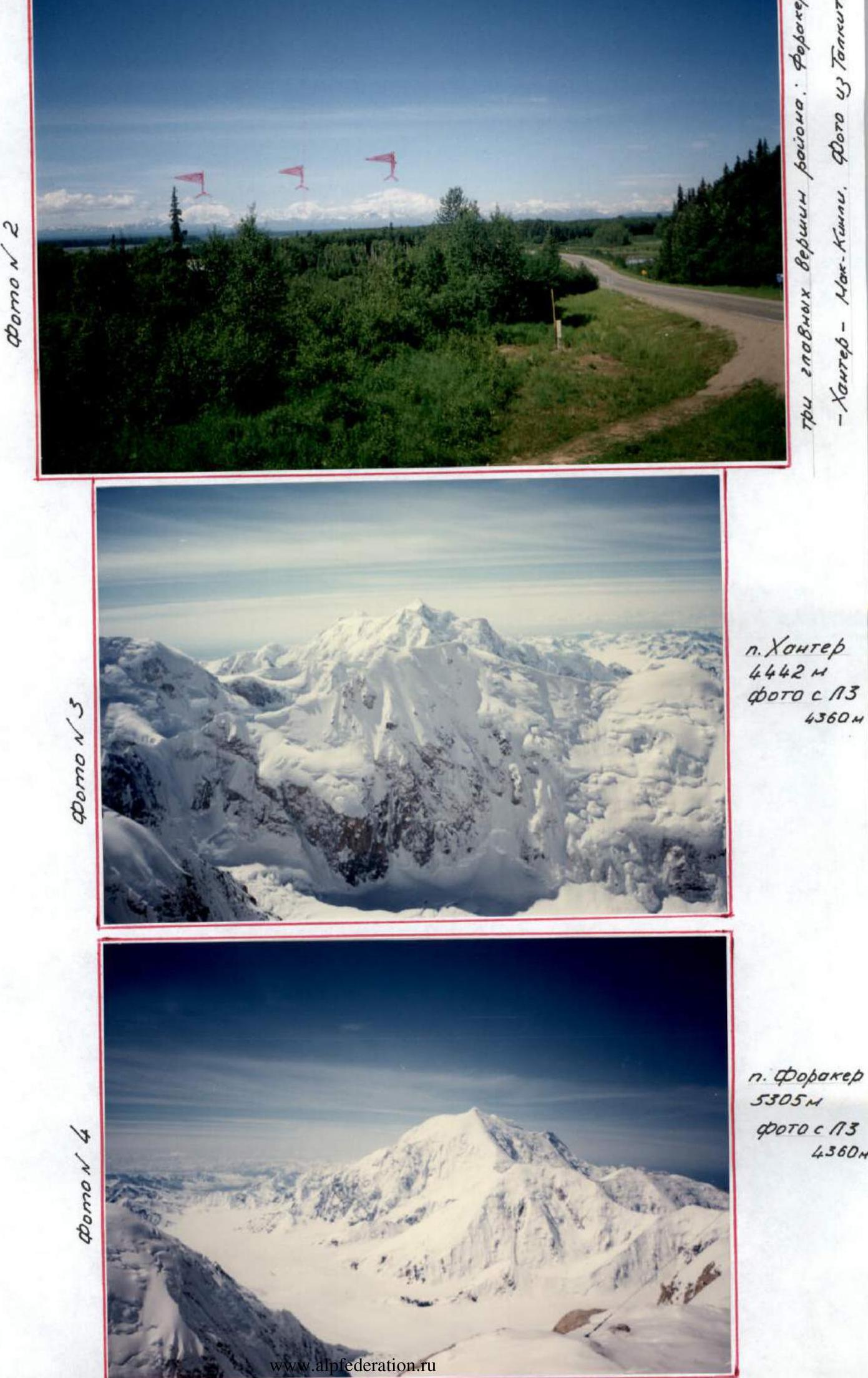 Photo #2
Mt. Hunter 4442 m, photo from L3 4360 m
 Mt. Foraker 5305 m, photo from L3 4360 m
Brief overview of the climbing area
Deep in Alaska rises the highest massif in North America — McKinley (6193 m). The snowy giant, located at 63° N latitude in the Alaska Range, is not only the highest peak in North America but also one of the highest mountains in the world. While the peaks of the Himalayas and the Andes certainly exceed it, they rise from plateaus with absolute heights of 3000 m and above. Here, however, the broad valley of the Kuskokvim River, into which the northern slope of the massif descends, is at an elevation of 450 m above sea level.
Among the nearest satellites of McKinley are very challenging peaks for climbers: Foraker (5303 m), the second highest in this group, has been conquered by only a few teams of climbers; Hunter (4443 m) and Mts. To (3150 m) are extremely difficult to climb and were conquered only recently. The chain of the Wrangell Mountains, located closer to the Gulf of Alaska, includes two high peaks — Blackburn (4918 m) and Bona (5004 m). The second highest peak in the area is Logan (6050 m), and the third is St. Elias (5488 m).
The high latitude at which the peak is located, its relative proximity to the ocean (250 km from the Gulf of Cook), and the cyclonic center over the Aleutian Islands, from which moist winds easily penetrate into the valleys of the Yukon and Kuskokvim, bringing heavy snowfall, all create harsh climatic conditions here, perhaps among the most severe in the world. In winter, temperatures can drop to -60° even in the valleys; in summer, average temperatures are around 12-14°, and occasionally can rise to 30° during the day. Nights are cold even in summer, and only in July are there almost no nighttime frosts.
The climate of Alaska and its mountainous regions is not only cold but also windy and humid. Cold southwest winds prevail (on peaks, their speed can reach 160 km/h) with short, even stronger gusts, very dangerous for climbers. Periods of bad weather last a very long time. For example, in 1947, out of ninety days in the three summer months, there were only five clear days, and on average, out of three days, two were cloudy.
Although precipitation in the valleys of Central Alaska is not high, storms bring a lot of snow to the mountain slopes, falling almost all year round. In summer, there can be up to 15-20 days with precipitation per month. The snow line is low — at an elevation of 1650 m. It is not surprising that huge glaciers are born on the slopes of such high mountains as McKinley and in the adjacent gorges, the largest of which are Kahiltna (73 km) and Muldrow (66 km) on the northern side of the McKinley massif.
The most suitable period for climbing is from May to the end of July, as the weather noticeably worsens in August. Clear weather is usually observed in the first half of the day; by noon, clouds already appear at elevations of 1200-2000 m. The following statistics indicate the most favorable conditions for climbing: from 1910 to 1972, the number of groups that successfully climbed McKinley was:
- in April — 2;
- in May — 23;
- in June — 28;
- in July — 47;
- in August — 9.
For a climber ready for hardships and difficulties and setting big sporting goals, Alaska offers a vast field of activity. However, on the approaches to the mountains, one has to:
- overcome glaciers and snowy slopes;
- endure changeable weather with lower temperatures;
- face stronger and more gusty winds than, for example, in the Caucasus or the Alps.
Moreover, expeditions to Alaska's mountainous regions still face difficult transportation problems. Although climbers no longer have to haul equipment and supplies on dog sleds as they did in the past, and air transport largely solves the transportation issues, climatic conditions still create significant obstacles.
The summit of McKinley attracts a large number of climbers from around the world. Several hundred ascents have been made by climbers from different countries. The success of these ascents can always be ensured only by:
- thorough preparation;
- excellent equipment;
- exceptional physical fitness of participants;
- "luck" with the weather.
On June 7, 1913, a group led by H. Stuck made the first successful ascent to the main (South) summit of McKinley. Today, more than 30 routes have been laid on this massif, information about which can be obtained at the ranger station in Talkeetna.
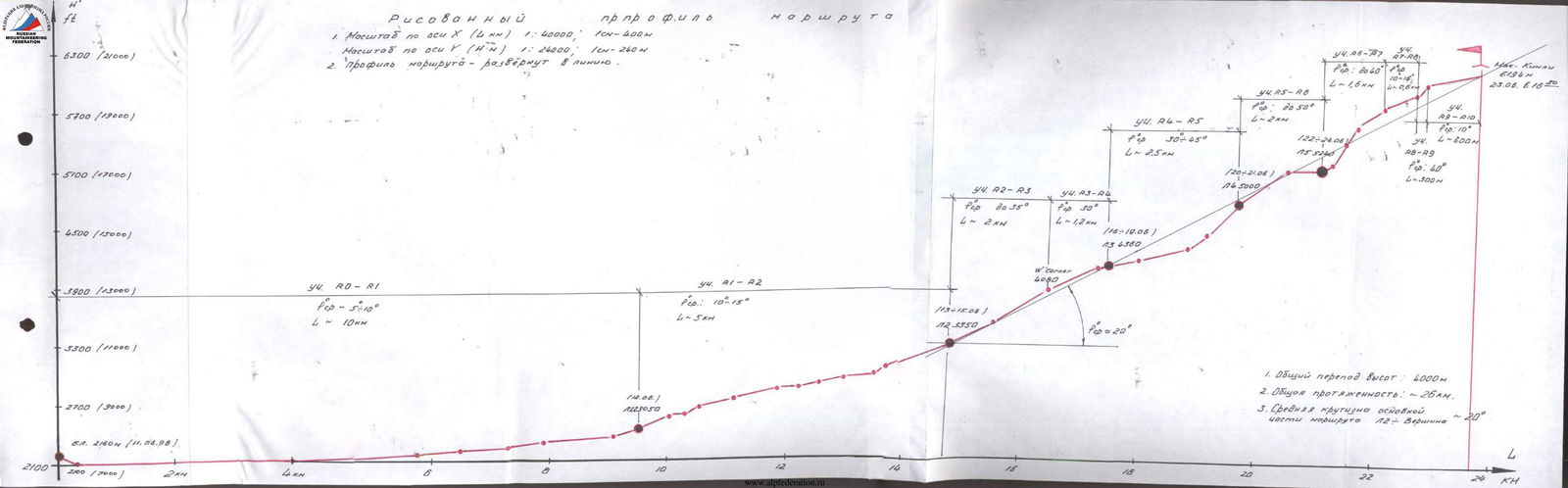
Profile of the route
- Scale:
- along the X-axis (4 km) — 1:40000 (1 cm = 400 m);
- along the Y-axis (H-N) — 1:24000 (1 cm = 240 m).
- Route profile — unfolded into a line.
- Section R0–R1
- Average steepness: 5–10°
- Length: 10 km
- Section R1–R2
- Average steepness: 10–15°
- Length: 5 km
- Section R2–R3
- Average steepness: 20–35°
- Length: 2 km
- Section R3–R4
- Average steepness: 30°
- Length: 1.2 km
- Section R4–R5
- Average steepness: 30–45°
- Length: 2.5 km
- Section R5–R6
- Average steepness: up to 50°
- Length: 2 km
- Section R6–R7
- Average steepness: 20–40°
- Length: 1.6 km
- Section R7–R8
- Average steepness: 10–15°
- Length: 0.6 km
- Section R8–R9
- Average steepness: 40°
- Length: 300 m
- Section R9–R10
- Average steepness: 10–15°
- Length: 800 m
Points on the route:
- Base Camp 2160 m (June 11, 1998)
- L1 2350 m (June 12)
- L2 3350 m (June 13-15)
- W'Corner 4080 m
- L3 4360 m (June 16-19)
- L4 5000 m (June 20-21)
- L5 5240 m (June 22-24)
- Summit 6194 m (June 23, 1998, 16:30)
- On descent: L3 4360 m (June 25), L2 3350 m (June 26), Base Camp 2160 m (June 27)
Summary data:
- Total elevation gain: 4000 m
- Total length: ~26 km
- Average steepness of the main part of the route to the summit ~20°
www.apfederation.sote↗ 1650 m. It is not surprising that huge glaciers are born on the slopes of such high mountains as McKinley and in the adjacent gorges, the largest of which are Kahiltna (73 km) and Muldrow (66 km) on the northern side of the McKinley massif.
The most suitable period for climbing is from May to the end of July, as the weather noticeably worsens in August. Clear weather is usually observed in the first half of the day; by noon, clouds already appear at elevations of 1200-2000 m. The following statistics indicate the most favorable conditions for climbing: from 1910 to 1972, the number of groups that successfully climbed McKinley was: in April — 2, in May — 23, in June — 28, in July — 47, and in August — 9.
For a climber ready for hardships and difficulties and setting big sporting goals, Alaska offers a vast field of activity. However, on the approaches to the mountains, one has to:
- overcome glaciers and snowy slopes;
- endure changeable weather with lower temperatures;
- face stronger and more gusty winds than, for example, in the Caucasus or the Alps.
Moreover, expeditions to Alaska's mountainous regions still face difficult transportation problems. Although climbers no longer have to haul equipment and supplies on dog sleds as they did in the past, and air transport largely solves the transportation issues, climatic conditions still create significant obstacles.
The summit of McKinley attracts a large number of climbers from around the world. Several hundred ascents have been made by climbers from different countries. The success of these ascents can always be ensured only by:
- thorough preparation;
- excellent equipment;
- exceptional physical fitness of participants;
- "luck" with the weather.
On June 7, 1913, a group led by H. Stuck made the first successful ascent to the main (South) summit of McKinley. Today, more than 30 routes have been laid on this massif, information about which can be obtained at the ranger station in Talkeetna.
Preparation for the ascent
The real opportunity to organize an expedition to the highest peak in North America — Mt. McKinley (Denali, 6194 m) — arose for our team in early spring. Thanks to the active support of the Central Committee of Trade Unions of the Nuclear Industry, the main issue — partial financing of the team — was resolved. Everyone wanted to visit a new, interesting area from an alpinist's point of view and complete an ascent there. All team members had visited many "high" mountain regions of the former USSR, China, Nepal, and South America in different years, completing many interesting and challenging ascents, including those at the Championships of the USSR and Russia. All team members are "Snow Leopards."
Based on materials from domestic and foreign press, as well as the experience of other groups' ascents, we had sufficient information about the object of our ascent. The main issue to be resolved was organizational (air tickets, visas, preliminary application, and agreement with the American side). Yanochkin V. I. did a lot of work in this direction. All negotiations were conducted with representatives of the Ranger Station, located in Talkeetna (Denali National Park, Alaska, USA).
As mentioned above, all team members knew each other well and had participated together in many expeditions.
Throughout the year, each participant maintained a good level of physical fitness. Many took part in traditional athletic, skiing, and rock climbing competitions:
- Cross "In Memory of the Eight";
- Race "In Memory of Friends";
- "Ski Track of Russia";
- "Prize named after I. Erohin";
- Various biathlons;
- Many other competitions.
Before flying to Alaska, some participants had already spent time at high altitude and were well acclimatized; others had to start the ascent from "scratch." Therefore, the team had to develop a clear acclimatization plan through a competent choice of the ascent route.
There are more than 30 routes and their variations on McKinley today. We considered the Southwest side of the object. Based on the material we gathered and considering the harsh climatic conditions, the choice was made in favor of the West Counterforce. This route is logical, relatively safe, and interesting from an alpinist's point of view. The route includes:
- heavily broken icefalls;
- steep snow-ice slopes;
- sharp ridges;
- icy rock sections.
The weather is very unstable, with frequent snowfall, strong winds, and temperatures reaching -25° in the upper part of the route.
There are problematic sections on the route (see the "Route Description by Sections"), which we addressed. A corresponding tactical plan for the ascent (alpine-style ascent with partial preliminary caching along the ascent route) and belay technique were developed. Step-by-step acclimatization was not conducted.
Before starting the ascent, all unclear issues were resolved at the Ranger Station, and necessary consultations were obtained.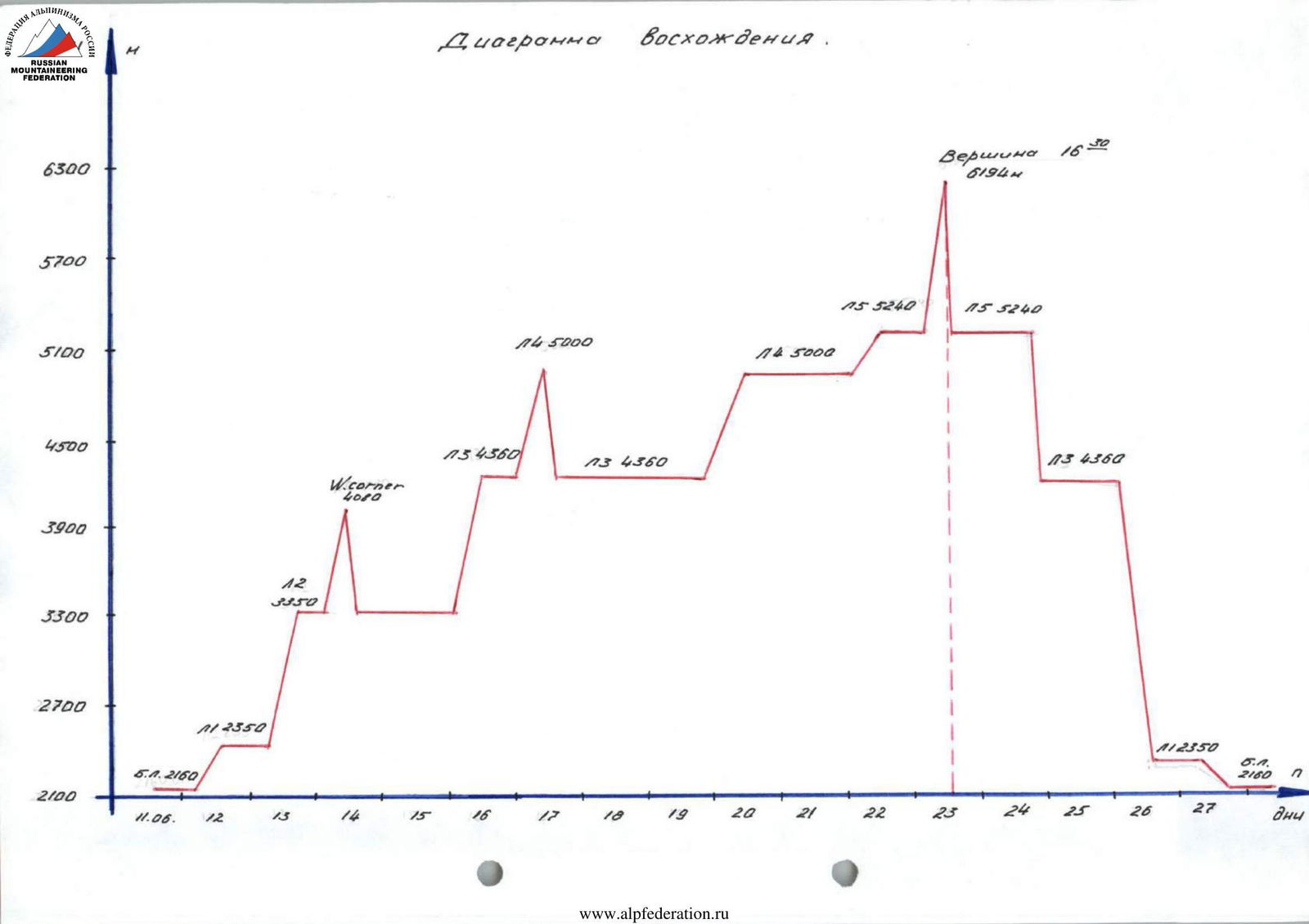
Tactical actions of the team
Based on the material we gathered about the climbing area, its specifics, and considering the experience of previous Russian teams, we developed a tactical scheme for the ascent back in Moscow. Deviations were minor and predictable.
The tactics for ascending Mt. McKinley (6194 m) were chosen to be alpine-style, but with a fairly even pace on the route and partial caching along the way, which contributed to our acclimatization. Rest days were planned in high-altitude camps in case of bad weather. Caching and acclimatization exits were made:
- from L2 (3350 m) to W'Corner (4080 m);
- from L3 (4360 m) to L4 (5000 m).
Five high-altitude camps were planned on the route.
- All camps were located on flat, safe snow-ice platforms, surrounded by snow walls.
- Good high-altitude tents allowed us to forego caves.
- Camp locations were chosen in known areas.
Movement to L2 (3350 m), and further depending on snow conditions, was done on Ski-tour or snowshoes with the use of transport sleds, up to L3 (4360 m). The duration of the ascent, favorable snow-ice conditions on the route, and a large load contributed to the use of transport sleds.
These sections of the route were marked in case of bad weather. Marking with stakes was also planned on other sections where circumstances required it.
On sections R4–R6 (4360–5240 m), movement was in rope teams, using ice screws and anchor hooks for belay.
On other steep sections R6–R10 (5240–6194 m), belay was organized through ice axes.
In case of unforeseen situations, communication could be established through ranger stations (L3 and L5) or other teams.
Thanks to the polar day and harsh polar conditions, the team did not plan very early starts (see the ascent schedule). The distance between high-altitude camps allowed it to be covered at the optimal time of day.
For cooking, the team used stoves:
- "Febus";
- "MSR".
The initial weight of backpacks was 10-15 kg, and sleds — 30 kg. Special attention was paid to the ecology of the area, as required by local laws.
There were no injuries, frostbites, or falls on the route.
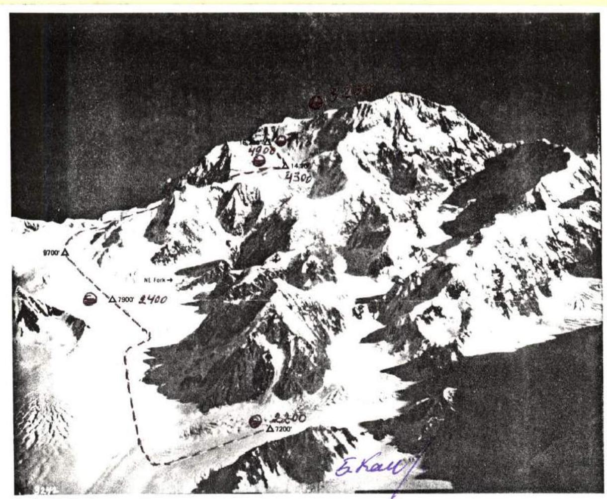
Route diagram in UIAA symbols
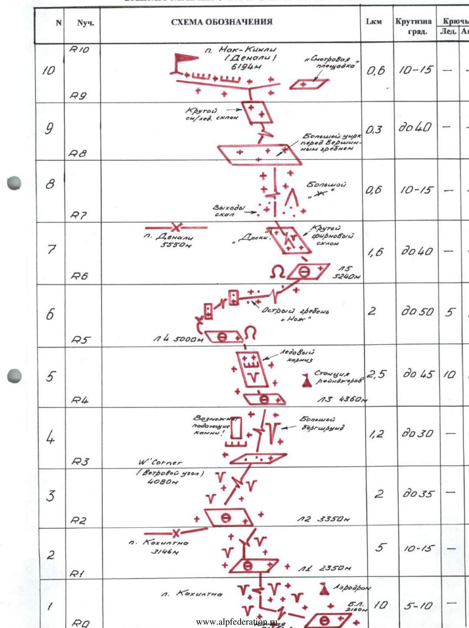
Route description by sections
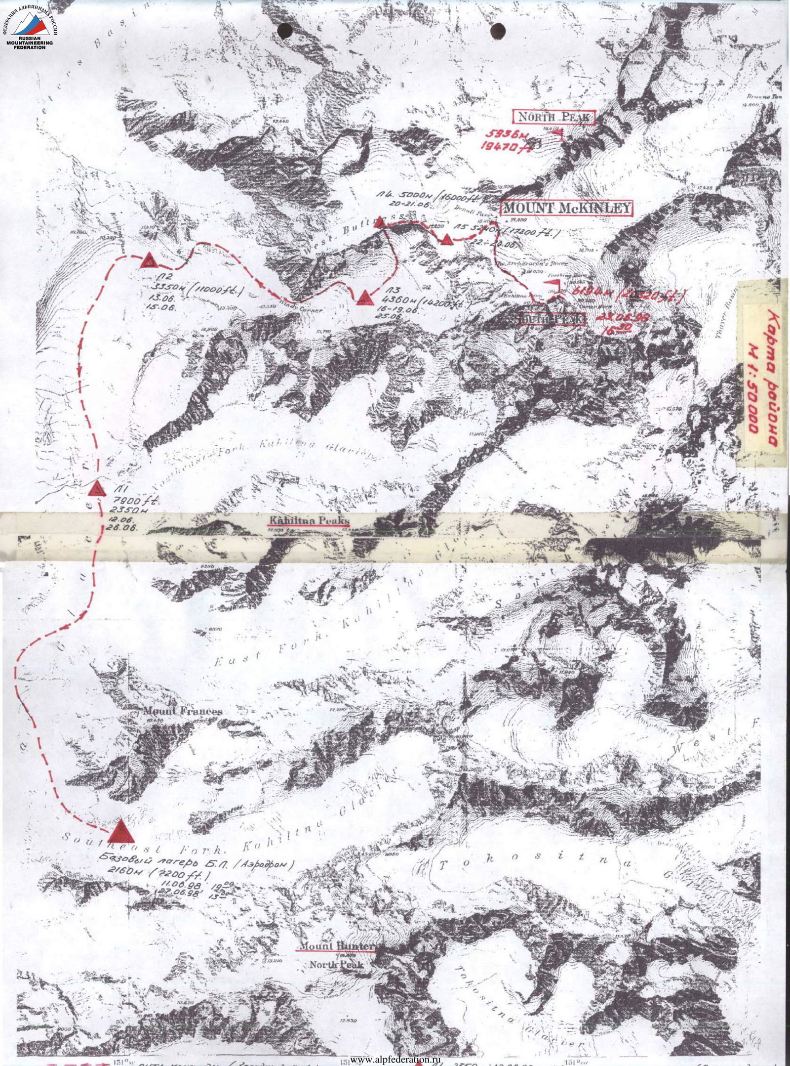
Section R0–R1 (photos 9, 10)
From the base camp (2160 m), located on the southern branch of the Kahiltna Glacier, the path leads West towards the main branch of the glacier. Then North, being cautious, as it's easy to get lost and end up near Mt. Frances, located in the northern corner of the fork. Further, a steep ascent onto the Kahiltna Glacier. Attention — large groups of crevasses. The path leads to a vast, flat area (2300 m). Here is Camp 1 (2350 m).
Section R1–R2 (photo #11)
Further movement is along the edge of crevasses towards the Kahiltna Pass (3146 m). Do not ascend to the pass. The glacier levels out. Then, turn East at an unnamed fork in the glacier and ascend into the cirque (3350 m). Be attentive to the threatening seracs located on the upper slopes. Fragments below some of them indicate that they are active. Here is Camp 2. Movement on sections R0–R2 is autonomous, preferably on Ski-tour or snowshoes.
Section R2–R3 (photos #12, 15)
The path then deviates Northeast, ascending to "Squirrel Hill." The wall leading to the ridge crest is sometimes called Lang Rocks. This ridge can be considered the lower part of the West Counterforce. From the ridge, the path goes East, staying with the northern rocks of the ridge. At an elevation of 3600 m, the ridge ends with a wide rocky plateau. This place is called "Windy Corner." During strong storms, avalanches are possible here.
Section R3–R4 (photos #14, 16)
From the edge of the plateau in a Southeast direction, there is a not very deep gully in the rocks. Then, turn East and along the foot of the West Counterforce (possible rockfall), make a diagonal traverse over giant crevasses. This area is heavily broken by crevasses. Movement is on crampons. Continuing to bypass the foot of the counterforce, slightly deviating North, you reach the foot of a large ice bowl, passing numerous crevasses and bridges along the way. This is an ideal place for Camp 3. The summit cloud cap rarely descends this low, and low-flying clouds do not reach this height. The elevation here is 4360 m.
Section R4–R5 (photos 15, 17, 18)
Then, crossing the bowl in a North direction, you reach a steep snow-ice slope. The steepness here reaches 45°. In the middle part, there is a small ice ledge. Movement is alternating in rope teams, with belay through ice screws and anchor hooks. In the upper part of the slope, there are rocks (simple climbing). Ascent to the ridge. Organization of Camp 4 (5000 m). The black rocks of the North Peak are noticeable.
Section R5–R6 (photo 19)
The path then goes East. First, a fairly steep snow-ice ridge. A system of diagonal traverses, where steep icy rock walls are encountered. After "Big Rock" begins a sharp ridge "Knife." Further, along the destroyed snow-rock ridge, movement is Southeast, gradually entering a wide snow-ice couloir, left of the main rock ridge. This place is called "Raven's Nest." Movement on this section is on crampons, preferably in rope teams. Belay is organized using ice screws and anchor hooks. Further, Southeast to Camp (5240 m), located in a giant snow "dish." The thickness of the snow cover allows for digging caves here.
Section R6–R7 (photo 21)
Ascent along a steep firn slope (attention: overhanging slabs) in a Northeast direction to Denali Pass (5550 m). Movement is on crampons with ice axes. Belay is through ice axes. Steepness reaches 40°.
Section R7–R8 (photo 20)
Further movement is South towards "Big Gendarme" (bypass on the left). This is a wide snow ridge with small rock outcrops. A smooth turn Southeast and exit into a large Cirque before the summit ridge. Movement is autonomous.
Section R8–R9
Crossing the Cirque in a Southeast direction, you reach a steep snow-ice slope, ending with the main pre-summit ridge. The slope's steepness is up to 40°.
Section R9–R10 (photo #22)
A sharp ridge, movement Northeast. On the left side of the ridge, there are giant cornices. Movement is in rope teams, with belay through ice axes. Further, exit to the summit of McKinley (Denali) 6194 m.
Descent is via the ascent route.
List of equipment
- Main rope 10 mm, 25 m — 3 pcs.
- High-altitude tents (firm "MEGATECT") — 3 pcs.
- Gas burners — 1 pc.
- "Febus" stove — 1 pc.
- "MSR" stove — 1 pc.
- Gasoline — 8 l
- Gas cartridges (250 ml) — 2 pcs.
- Carabiners (including personal) — 15 pcs.
- Climbing harnesses — 5 pcs.
- Ice axes — 4 pcs.
- Ice axe — 1 pc.
- Ice screws — 5 pcs.
- Snow anchors — 2 pcs.
- Telescopic poles — 5 pairs
- "Ski-Tour" kit — 4 sets
- Snowshoes — 1 pair
- Cookware — 1 set
- Headlamp — 1 pc.
- Transport sleds — 5 pcs.
- Marking stakes kit — 1 set
- Jumars — 5 pcs.
- First aid kit — 1 set
- Cameras — 5 pcs.
- Windproof and down clothing kit — 5 sets
- Sunglasses — 5 pcs.
- Crampons — 5 pairs

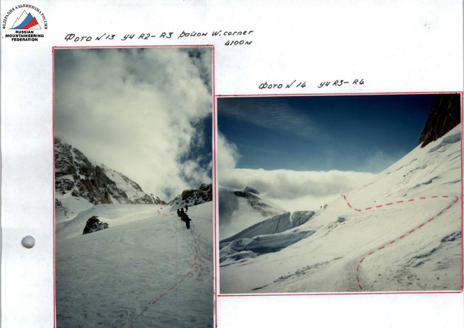
Photo #15 A3 6360 44
A6–A5
Photo #18 44
A3–A4
Denali National Park and Preserve, Alaska
National Park Service U.S. Department of the Interior

Protocol of the ascent review on Mt. McKinley (6194 m) via West Counterforce, 5B category of complexity
Talkeetna, Ranger Station, June 24, 1998, 15:00, Alaska, USA
Senior coach of the team — Nevrotin V. K. (MS)
The object of our ascent is Mt. McKinley (Denali) 6194 m, the highest peak in North America and the northernmost 6-thousander on Earth. A peculiarity of this object is its proximity to the Polar Circle and a large elevation gain (4000 m). These features and quite unstable weather conditions make this peak a serious test for climbers and "bring it closer" to our 7-thousanders.
Our team chose the West Counterforce as the route. Despite being a fairly popular route among climbers and considered classic, its "ease" is deceptive. According to statistics, less than 25% reach the summit. For many groups, this route has become a "trap," from which it is quite difficult to escape, and they have to turn back.
The nature of the route is diverse. Here you can find:
- heavily broken glacier sections;
- bottomless crevasses;
- steep snow-ice slopes;
- sharp ridges;
- icy rock sections;
- snow cornices.
Bad weather further complicates the route.
The ascent tactics were chosen to be alpine-style, but with partial caching on the ascent, which contributed to our acclimatization. Throughout the ascent, the team maintained a steady pace, although there were periods of waiting out bad weather. On complex and dangerous sections, all safety measures were observed with reliable belay. All participants reached the summit.
I would like to express special gratitude to the Central Committee of the Trade Union of Nuclear Industry Workers and personally to Y. I. Tychkov for the assistance provided in conducting the expedition.
Team captain — Yanochkin V. I. (MSMK)
I have been to McKinley for the second time. Last year, I climbed this route with F. Konukhov. I agree with V. K. Nevrotin. The lower part of the route is a wonderful place for ski mountaineering. The route is quite serious, logical, and relatively safe. Other ascent options were considered, but the West Counterforce was chosen. The Americans' attitude towards the mountain in terms of ecology and safety organization during the ascent is impressive.
There are no comments on the coach and team members.
Lavriyenko V. V. (MS)
I have long wanted to climb McKinley, and now this opportunity arose. I am grateful to everyone who helped me. Alaska is a unique area in terms of beauty, unlike any other place I've been. Clear and competent preparation for the expedition allowed us to avoid many problems. The developed ascent tactics were correct, which allowed all participants to reach the summit.
The route itself is not simple, but logical and interesting. There were practically no deviations from the previously developed ascent schedule.
There are no comments on the leadership and team members.
Melnik V. (MS)
This is my first time abroad, and I'm glad to have had the opportunity to visit Alaska and climb McKinley. The climbing area is very beautiful, with many other interesting peaks, including technically challenging ones. The route fully corresponds to our high-altitude "five." I liked the team collective, which can solve more complex tasks. I have no complaints about it.
Sushko A. (MS)
I'm very glad to have been on the summit, especially after a not entirely successful Himalayan season. I agree with the opinions of the team members. I would like to visit other beautiful peaks of the Earth with this team.
Representative of the Rangers (rescue service of the area)
We have no complaints about the group. All measures for conducting a mountaineering ascent on Mt. Denali (6194 m) were observed, safety was not compromised, and ecological requirements were met. The fact of the team's presence on the summit is evident. We are always happy to welcome new groups from Russia.
 Team coach — Nevrotin V. K. (MS)
Team captain — Yanochkin V. I. (MSMK)
Ascent passport
- Ascent class: high-altitude
- Ascent area, ridge: USA, Alaska Range
- Peak, its height, ascent route, route character: McKinley (6194 m) via West Buttress route, ice-snow
- Proposed category of complexity: 5B
- Route characteristics:
- Elevation gain: 4000 m
- Length of section with 5-6 category complexity: none
- Average steepness: 30°
- Hooks driven:
- Rock: none
- Ice: 4 (none)
- Pitons: none
- закладных элементов: none
- Number of travel hours: 40 h
- Number of overnight stays: 5 (lying down)
- Team composition:
- Kashakashvili Benedikt Guramovich, MS — leader
- Gudzhabidze Bidzina Sergeyevich, MS
- Sarkisov Lev Arshakovich, MS
- Team coach: Sarkisov L. A.
- Date of departure on route: May 1-5, 1996
- Organization: Club "Alpinindustry" Ltd.
Team captain: B. Kashakashvili
 view from the South
Protocol of the ascent review on Mt. McKinley by the team of "Alpinindustry" Club (Georgia, Tbilisi) within the framework of the Championship of the Euro-Asian Association of Mountaineering and Rock Climbing in the high-altitude class
Present: participants of the ascent, F. Mayer (US climber).
Speakers:
1. B. Kashakashvili (ascent leader):
We prepared for the ascent quite seriously, studied materials on the climbing area, and consulted with climbers who had been to the summit. We completed several winter ascents on Mt. Kazbek with an overnight stay on the summit and carefully prepared our equipment.
2. B. Gudzhabidze:
The ascent route is not particularly complex technically, but the specifics of the area, its proximity to the polar circle, the large area of glaciation, the need to carry a large load, and pull sleds — give grounds to assess it as 5B category complexity.
3. F. Mayer:
I was impressed by the pace of the ascent and the climate of friendship not only among team members but also towards foreign climbers. The first Georgian expedition to McKinley left a good mark on American soil.
4. L. Sarkisov (coach, team manager):
The ascent proceeded at a good pace. The group worked cohesively, evenly distributing the load. We overtook many teams from different countries that had started the route a week or two before us. Despite the frost (-30°) and strong wind, we were the first on the summit in the current season. We retrieved a note left by Russian climbers in 1995, which, unfortunately, we were supposed to hand over to the rangers for storage.
I approve the ascent and recommend it for the Championship of the Euro-Asian Association of Mountaineering and Rock Climbing.
Recorded by L. Sarkisov