
Passport
- Rock climbing category
- USA. State of California. Sierra Nevada mountains. Yosemite National Park.
- "Lost Arrow Spire. Direct Route". Center of the south wall.
- Proposed — 6B category of difficulty. First repeat by a Russian team
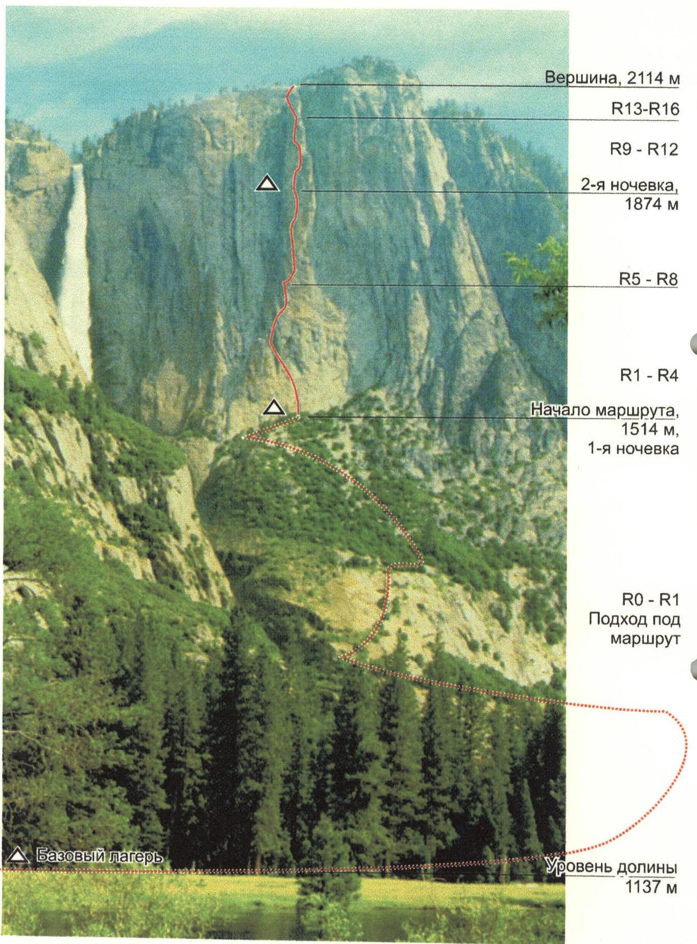
- Height difference: 977 m. Wall section height difference: 600 m.
Length: 635 m. Average route steepness: 84°. Length of sections with VI category of difficulty — 400 m, V category of difficulty — 155 m.
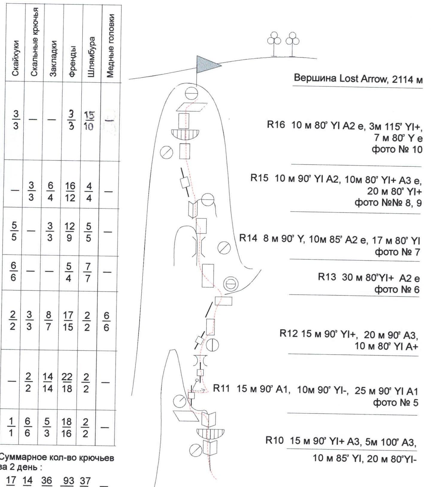
- Number of pitons driven:
| Skyhooks | Rock Pitons | Chocks | Cams | Bolt Pitons* | Copper Heads |
|---|---|---|---|---|---|
| 34 | 21 | 68 | 201 | 68 | 6 |
| 34 | 21 | 50 | 137 | 63 | 6 |
* — Bolt pitons were previously driven and in good condition. Driving in new bolt pitons is prohibited on previously climbed routes.
Pitons left on the route (not removed) — 3 pcs. Previously driven bolt pitons used — 68 pcs.
- Team's working hours: 30 hours, days — 3
- Overnights: 1st — in a tent under the wall, 2nd — on a rock ledge with safety rope attached to the railing.
- Team leader: Galina Volgina, CMS, instr. 2 cat. — Team members: Alexander Baichurin, CMS, captain — Ivan Benedyk, 1st sports category, Oleg Chirik, CMS
- Coach: Valery Karpenko, MS
- Departure to the route: May 22, 1998.
Summit — May 24, 1998. Return — May 24, 1998.
- Organization — Department of Education, Physical Culture, and Youth Policy of the Kamchatka Region Administration (Kamchatka Alpine Federation)
General photo of the summit
Profile of the wall on the right
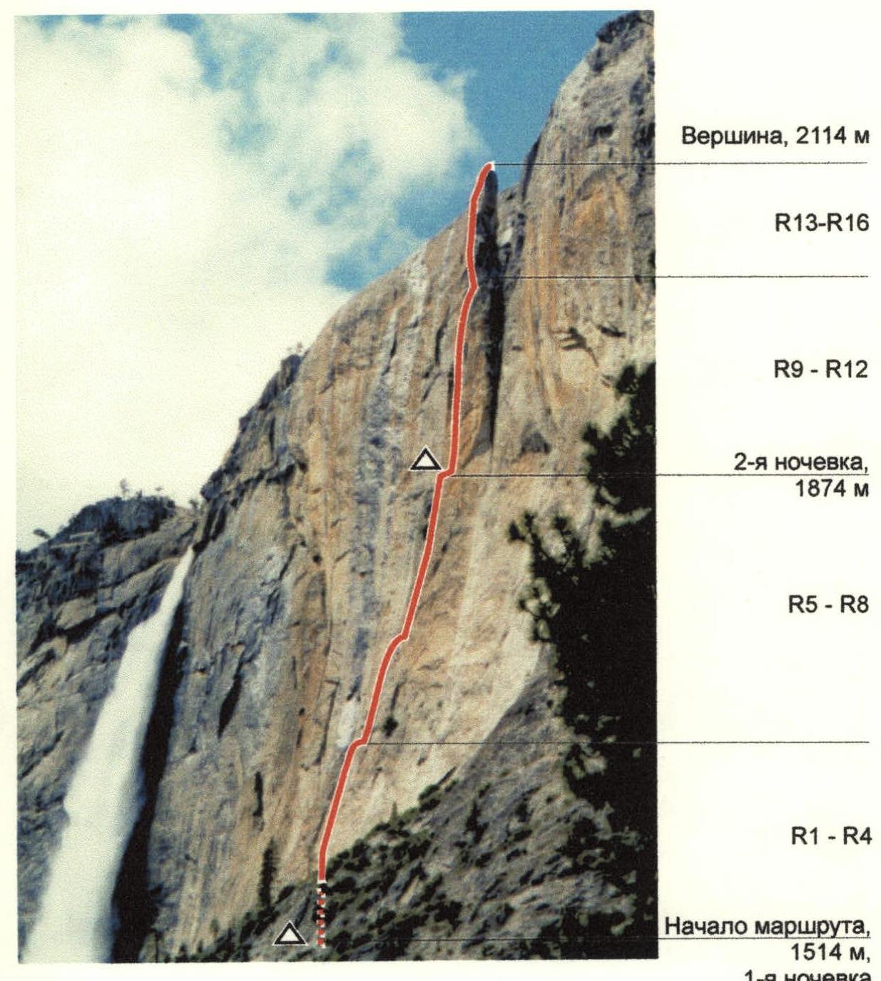
Photo taken with a "MINOLTA" camera with a 135mm ZOOM lens while approaching the route on May 22, 1998.
Profile of the wall on the left
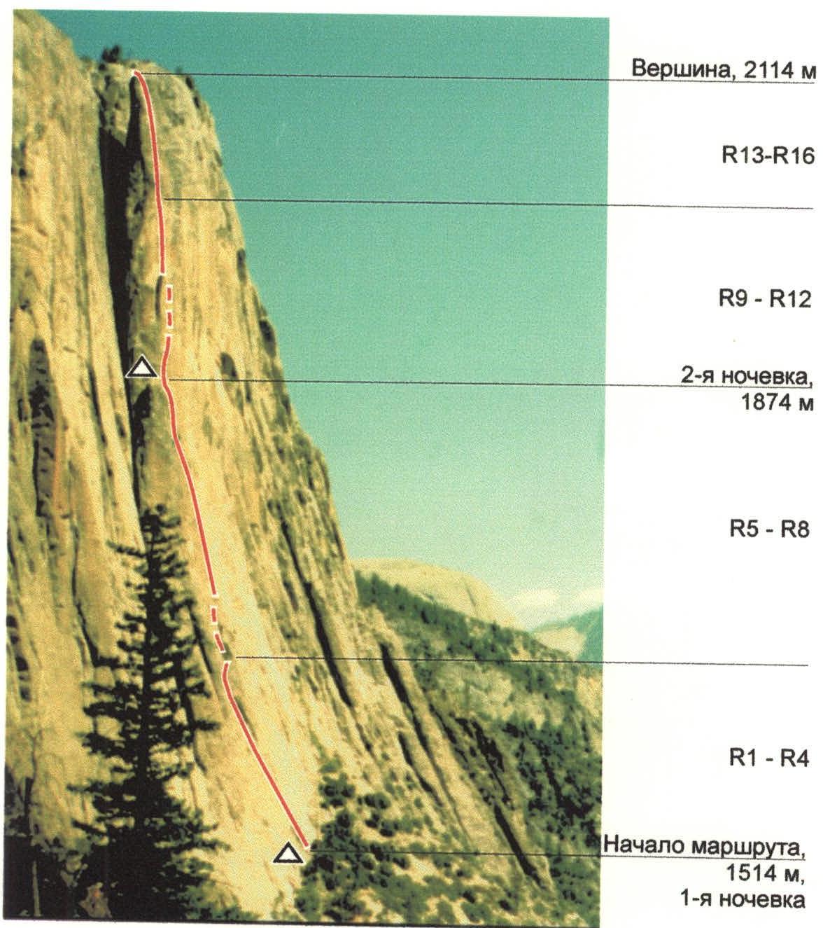
Photo taken with a "MINOLTA" camera with a 135mm ZOOM lens from the "Top of Yosemite Falls" trail at an elevation of 1650 m on September 15, 1997.
Panorama of the Upper Yosemite Falls wall routes
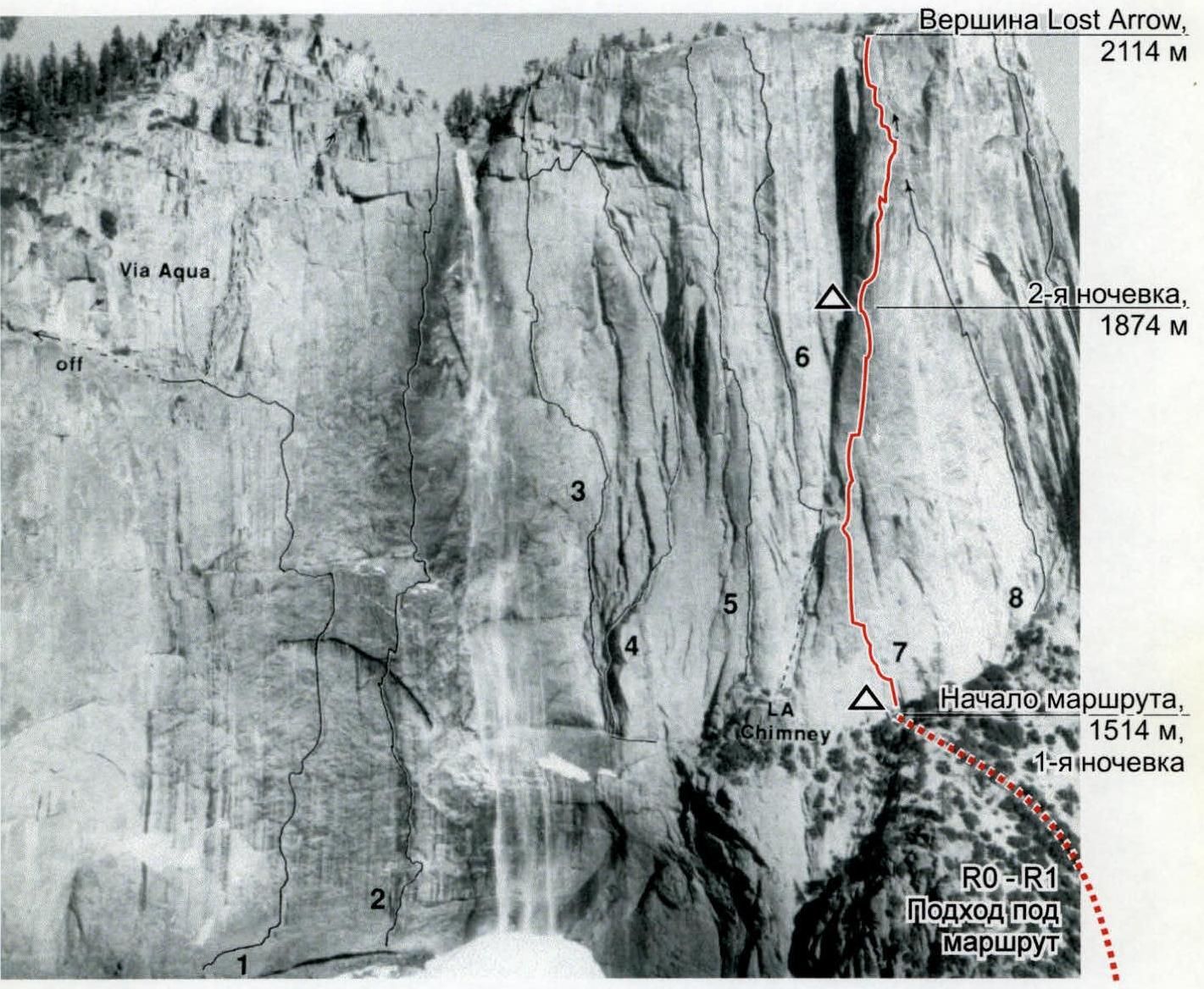
Photo from the book "Yosemite Climbs. Big Walls", p. 110
Valley level 1
- Wheel of Torture YI 5.7 A4
- World of pain YI 5.8 A5
- Via sin Liquor YI 5.9 A4
- Misty Wall Y 5.11d AO
- Aqua Vulva YI 5.10 A4
- Dante’s Inferno YI 5.9 A3+
- Lost Arrow Spire, Direct Route YI 5.11 A3
- Yosemite Pointless Y 5.9 A3
- Czech Route YI 5.10 A3
Preparation for the ascent
The Kamchatka Alpine Federation has been conducting annual mountaineering expeditions in the USA since 1994. The Kamchatka climbers first visited Yosemite in 1996, led by Valery Karpenko. They inspected routes, acquired guides, maps, and catalogs of necessary equipment.
In September 1997, an expedition led by Valery Karpenko was conducted in Yosemite, consisting of 9 people. Ascents were made in the El Capitan area:
- "The Folly" Y 5.10d A2
- "The Moratorium" Y 5.11b A2
- on El Capitan via "West Face" YI 5.11C A2 (according to the American classification)
- and others.
Before heading to Yosemite, a week of training on artificial terrain was conducted in the "Rock Gym" hall in Seattle. The best time for climbing in Yosemite (according to all consultations) is September and April–May. From personal experience, it was found that September is the most visited time; there are queues for routes, it's dry and hot, so the dates for the next expedition were set for April–May 1998, within the framework of the Russian Championship with ascents on El Capitan, Half Dome, and Lost Arrow.
Unfortunately, this spring (late April, May) Yosemite experienced the most unfavorable weather in the last 30 years. For a month of our stay, it rained almost every day, with snow above 1500 m, temperatures ranging from 7–10 °C during the day to 0 °C at night. The climbing schedule was disrupted. The team on the route "The Nose" on El Capitan reached section #22 and had to descend due to worsening weather (snow, wind, icing).
During the ascents in the past and current seasons in Yosemite, experience was gained:
- moving a group with a load of up to 50 kg (2–3 bags)
- mastering work with a wide range of equipment on sections of A3, A3+, A4 artificial technical climbing
- using "RURP" pitons (for cracks up to 0.5 mm)
- copper heads for hammering into folds and micro-relief
- skyhooks for passing complex sections without protrusions or holds
All equipment was tested according to UIAA standards. Equipment used:
- For belaying: 11mm dynamic rope "EDELRID"
- For fixed ropes and transportation: 10mm static ropes "PMI"
- Cams: "Metolius" and "Black Diamond"
- Rock pitons: "Black Diamond"
- Chocks: "Black Diamond", "DMM"
Great importance was placed on overall physical fitness and rock climbing training. Kamchatka has an indoor climbing gym that meets the requirements of 1st-class competitions, equipped with "NICROS" holds. Team members are leading rock climbers in Kamchatka. In the Ganal'skiye Ostriaky area, 100 km from the city, participants made ascents of 5A, 5B category of difficulty with sections of extreme complexity. That is, the team was comprehensively prepared for the given route.

Ascent schedule
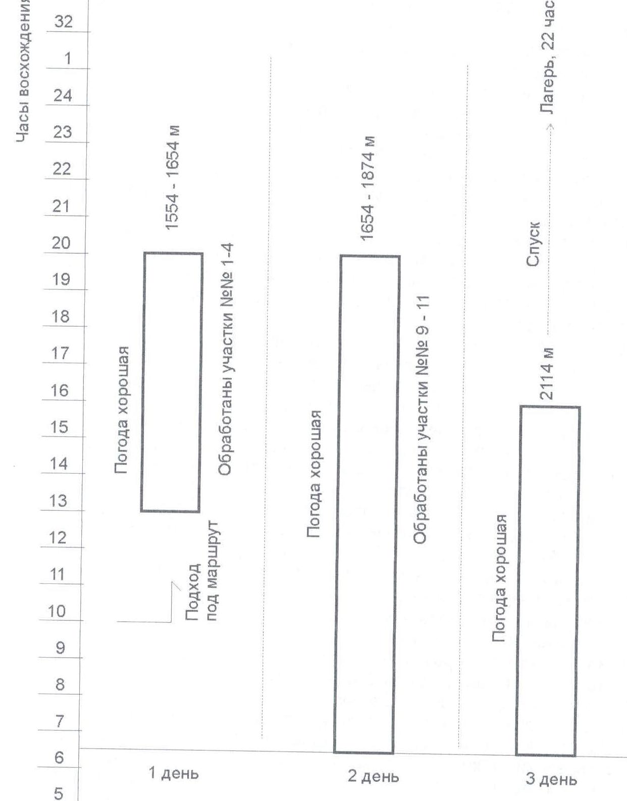
Tactical actions of the team
Ascent plan. Day 1:
- 10:00 — Departure from the base camp. Approach to the route.
- 13:00 — Processing 4 sections of the route. Lifting the load.
- 20:00 — Descent to the overnight stay.
Day 2:
- 05:30 — Ascent.
- 06:30 — Start working on the route.
- 15:00 — Reaching the start of section R9, ledge (planned overnight stay). Snack.
- 16:00 — Processing sections R9–R11.
- 20:00 — Descent to the overnight stay.
Day 3:
- 05:00 — Ascent.
- 06:30 — Start working on the route.
- 16:00 — Reaching the summit.
- 16-30 — Start of descent.
- 22:00 — Return to the base camp.
In case of worsening weather or late arrival at the summit, a normal overnight stay on the ledge under section R12 is possible. Descent from the summit via the ascent route. The tactical plan was made based on the route reconnaissance in autumn 1997. Deviations from the tactical ascent plan are minor.
The first in the trio worked in rock shoes, carrying only the necessary gear on a special harness. The weight of the gear for the first climber reached 10–11 kg.
Since the routes in this area are practically vertical, without macro-relief, and not prone to rockfall, with well-visible sections, there is a need to carry a large supply of water. A special scheme of climbing in a trio was applied here, followed by the team. The belay for the first in the rope was done with a single, 11mm dynamic rope "EDELRID", which was clipped through intermediate belay points. In addition, they carried a 10mm rope, intended for subsequent lifting of the transport bag with a load of food, water, and bivouac equipment.
The movement of the trio is as follows:
- The first climbs using free climbing or artificial aids to the next belay station, where the belay rope is fixed for the second.
- Then the first uses a "block-brake" on the 10mm rope to start lifting the transport bag.
- Simultaneously with the bag, the second in the trio starts moving on "jumar" ascenders, removing intermediate belay points as they ascend.
- They also accompany the bag, being attached to the transport rope, and reach the station simultaneously with the bag.
- The second also brings a separate fixed rope and a top-rope for the third's ascent.
- The third moves with a backpack on the fixed rope with top-rope belay.
- The first then prepares for further movement.
Every 2–3 stations, the lead climber changed. For artificial technical climbing, soft ladder sections made of webbing were used.
There are three good ledges on the route:
- The first is at the start of section R5.
- The second is on section R9.
- The third is on section R13,
where it's possible to stop for a meal, and in case of bad weather, set up a tent. The planned overnight stay is on ledge #2, measuring 3 × 2 m.
On sections R10 and R12, the difficulty for artificial technical climbing is A3 according to the UIAA classification. Here, the following were used:
- small, rigid, single-use pitons "RURP" with a thickness of 0.5 to 1.5 mm and a length of 3 cm — for extremely thin cracks;
- copper heads — for hammering into relief folds where there are no cracks.
Copper heads are also single-use and are hammered into relief folds and hollows using a hammer. "RURP" pitons and copper heads cannot be used as intermediate belay points, only for progression, so every 3–5 m, it's necessary to find an opportunity to establish an intermediate belay point. On sections R10 and R12, this is possible.
The team also widely used skyhooks, such as "spider" (three-pronged skyhook), for use on relief protrusions less than 10 mm, but it's more convenient to use them in a pre-drilled hole with a bolt punch to a depth of up to 10 mm.
It's very important to have a set of cams of very small sizes #00–02 "METOLIUS" for cracks from 8 to 20 mm. It's better to have a triple set. And it's also necessary to have 2–3 large cams (up to 18 cm).
It's particularly important to note the complete absence of water on all routes in this area. Water must be carried from the base camp, pre-packaged in plastic containers (in bottles wrapped with protective tape and equipped with a safety loop) at a rate of 3 l per person per day.
For transporting the load (water, food, bivouac, and personal equipment) weighing about 50 kg, a special transport bag "baul" was used, adapted for dragging along the granite wall.
For conducting ascents in this mountain area, there's no need to have a rescue team; a special medical insurance is sufficient, which was provided to all participants. There is a rescue service 911 and a medical clinic. In case of an emergency on the route, observers can call 911 or signal with a flare from the route.
Observation of the ascent was conducted from the hiking trail "Top of Yosemite Falls" using binoculars, from where the entire route is perfectly visible.
Route diagram in UIAA symbols M 1:2000

Route processing on the day of approach — 6 hours
Working hours on day 1 — 14 hours
*Note: The "bolt pitons" column indicates previously driven pitons in normal working condition that were used on the route.
Route diagram in UIAA symbols M 1:2000 (continued)
Working hours on day 2 — 10 hours
Description of the route by sections
Sections R1–R2
The route begins with an internal corner, open to the left, 12 m long. Then a traverse to the left along the wall. Station: bolt piton and cams. Further, 45 m of tense climbing along a vertical wall using artificial aids:
- In the first part, skyhooks are used, with protection through bolt pitons.
- In the second part, chocks and cams from small to medium sizes are used.
Station — an inclined ledge, bolt pitons.
Sections R3–R4
Section R3 begins with a 15 m chimney, transitioning into an internal corner, open to the right, with rounded edges.
- Protection is deep in the crack, uncomfortable, requiring cams up to 20 cm in size.
- Station — bolt pitons.
- Further, from the crack upwards along the wall.
- Intermediate protection through bolt pitons and cams.
- Exit to a large ledge, convenient for four people.
Climbing is mainly on artificial aids.
Sections R5–R6
Section R5 begins with a vertical wall without distinct relief, artificial aids, bolt pitons. Further:
- Thin crack 15 m.
- Pendulum to the right 5 m.
- Upwards along the vertical crack. Cams and chocks #00–7 (double set). Station — hanging, bolt pitons.
Further:
- Upwards along the vertical crack 25 m, in the last part — artificial aids on thin rock pitons.
- Then pendulum to the right 5 m.
- Upwards along the crack 20 m. Protection through chocks and cams of small and medium sizes, 2.5 sets. Station — hanging, bolt piton, cams.
Section R7
Upwards and to the right along the crack 30 m, partly on artificial aids. Further 20 m upwards along the cracks to the exit into a grotto with a tree. Station — tree.
Sections R8–R9
From the grotto upwards — exit to a large ledge with a place for overnight stay for four–five people. Overnight stay. Further along the smooth wall without relief upwards and to the right, in the middle part — a short crack for small cams. Movement is on skyhooks. Exit to a triangular ledge for two people standing. Station — bolt pitons.
Section R10
Climbing — artificial aids A3. In the middle part, a small overhang without relief, a key section. Overcome using short "RURP" pitons 2 cm long, then upwards along the crack to an inclined ledge. Station — behind a rock tooth and a bolt piton.
Section R11
Start — upwards along the crack, artificial aids — A2, pendulum to the right, 6 m is climbed free, further crack upwards and to the left to a rock spall, where an intermediate station is possible behind protrusions, to the main station — 8 m along the crack, artificial aids. Station — hanging near a small grotto, where it's possible to place a load.
Section R12
Tense climbing on artificial aids — A3. In the middle part, copper heads 8 mm are used for hammering into relief folds, as well as a "RURP" piton. Exit to a ledge where an overnight stay is possible, convenient for three people. Here it's possible to leave a load. To the summit — four stations. From here, it's possible to ascend to the saddle between the tower and the main wall of the massif.
Sections R13–R14
Upwards and to the left using skyhooks. Exit to the start of the chimney. Uncomfortable station through bolt pitons. Further:
- Upwards along the chimney 8 m long and 50 cm wide.
- Then movement along the smooth wall on skyhooks to a spall leading to a convenient ledge.
Section R15
Tense climbing along cracks and relief, artificial aids A2 for thin pitons. Station — hanging, uncomfortable.
Section R16
Section without distinct relief. Artificial aids. Passed on skyhooks. In the middle part, a small overhang. Then a gradually curving exit to the summit. Climbed along the crack. The summit is an inclined slab 6 m² in area. Descent from the summit via the ascent route.
Technical photo of the route
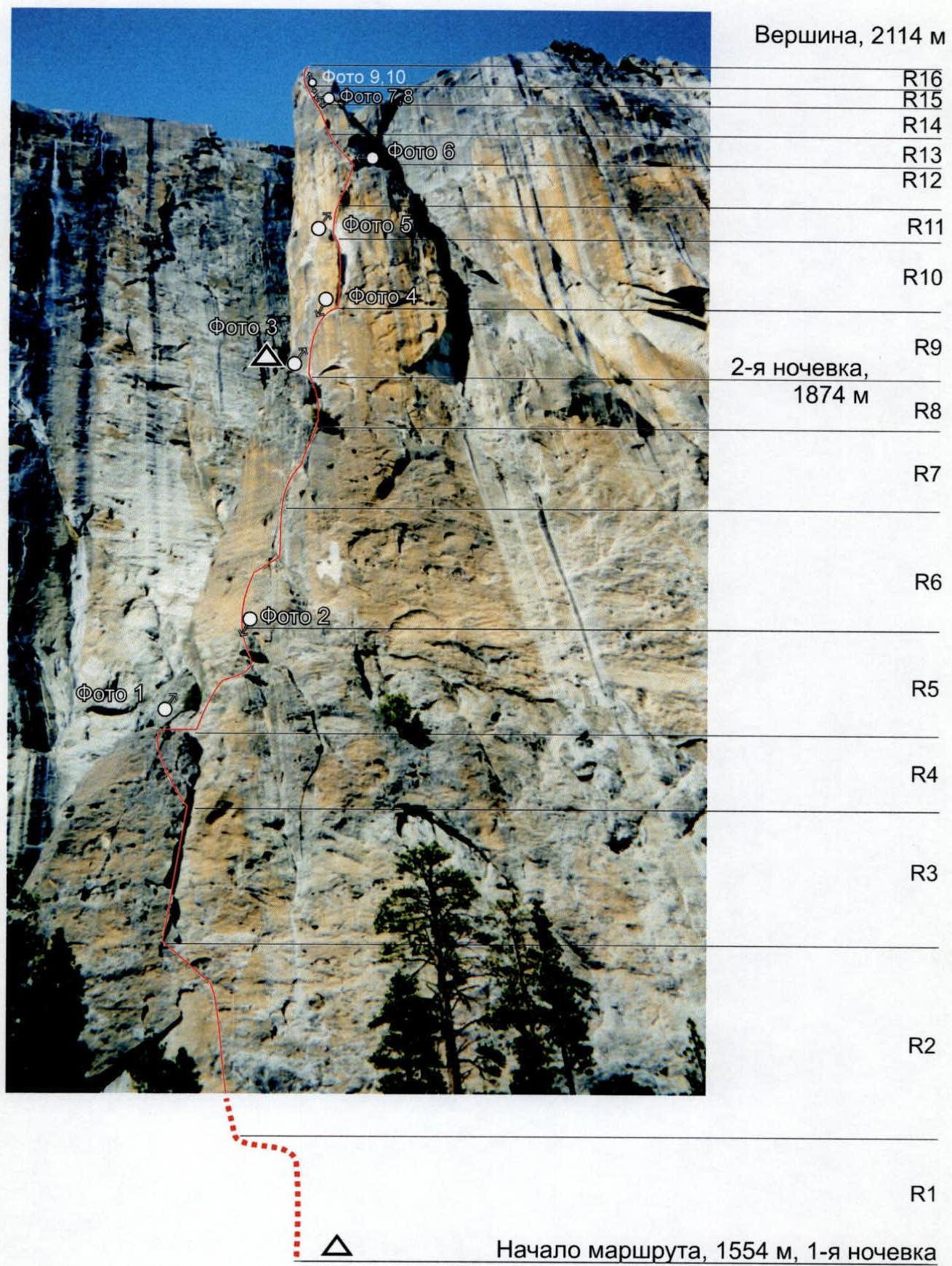
Photo taken with a "MINOLTA" camera with a 135mm ZOOM lens while approaching the route on May 22, 1998.
Photo #1

Photo taken with a "MINOLTA" camera with a 135mm ZOOM lens.
Photo #3
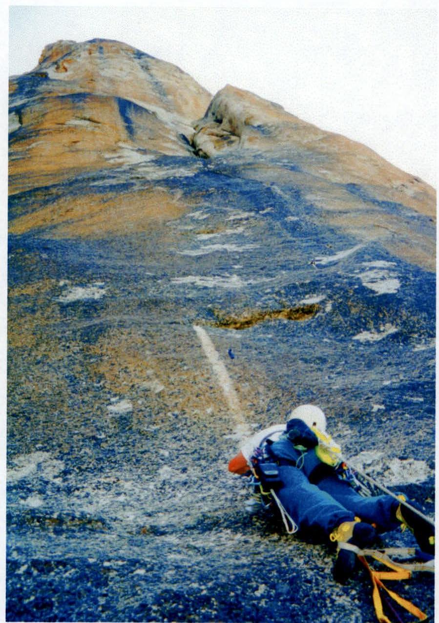
Photo taken with a "MINOLTA" camera with a 135mm ZOOM lens. Start of section R9. Movement on skyhooks.
Brief overview of the climbing area
Yosemite National Park is located in the central part of the Sierra Nevada mountain range, stretching from north to south through California, USA, for almost 800 km. The climbing area is situated in Yosemite Valley, approximately 240 km (150 miles) east of San Francisco, at an elevation of 1137 m (3960 ft) above sea level. To the east, the valley is bounded by the highest point in the area, Half Dome, 2540 m (8842 ft), and to the west, it extends about 18 km along the Merced River until it turns south. The width of the valley ranges from 1 to 2 km. The valley is bounded to the south and north by practically vertical granite walls over 1 km long, on which more than 200 mountaineering routes of Y–YI category of difficulty have been climbed. Just the famous El Capitan alone has 90 such classified ascent paths.
Virtually all forms of rock relief, short approaches to routes, good weather from April to October, detailed descriptions of routes on big and small walls, and year-round accessibility attract climbers and rock climbers from around the world, both renowned and novice. Yosemite is visited by more than 4 million people annually; the entrance is paid, and stay in the park is limited to 30 days from April to October. If you don't have a car, you can reach Yosemite Valley only by Gray Line bus from Merced, which runs daily to and from there.
Our group traveled from Seattle in a rented minivan. The journey took 2 days. From Stockton through Sacramento on highway #5, then east on road #120 through Moccasin to Yosemite Valley. Entrance through Big Oak Flat Entrance, with an entrance fee of $20 per car. Upon entering the park, you receive a free detailed map-guide and a seasonal newspaper-guide with the most comprehensive information on the state of all infrastructures and their operating modes.
The team stayed in their tents at the "Sunnyside" campground, $3 per person per night, where climbers usually stay. Food was purchased at a local store, and meals were prepared on stoves. In the valley, there are also hot showers, laundry facilities, cafes, restaurants, campgrounds, and hotels. A notable feature is the large number of wild bears, in addition to other animals, which can be encountered everywhere at any time of day and which break into and damage cars every night if they contain food or medicine. Detailed instructions on human behavior in areas inhabited by bears are posted everywhere.
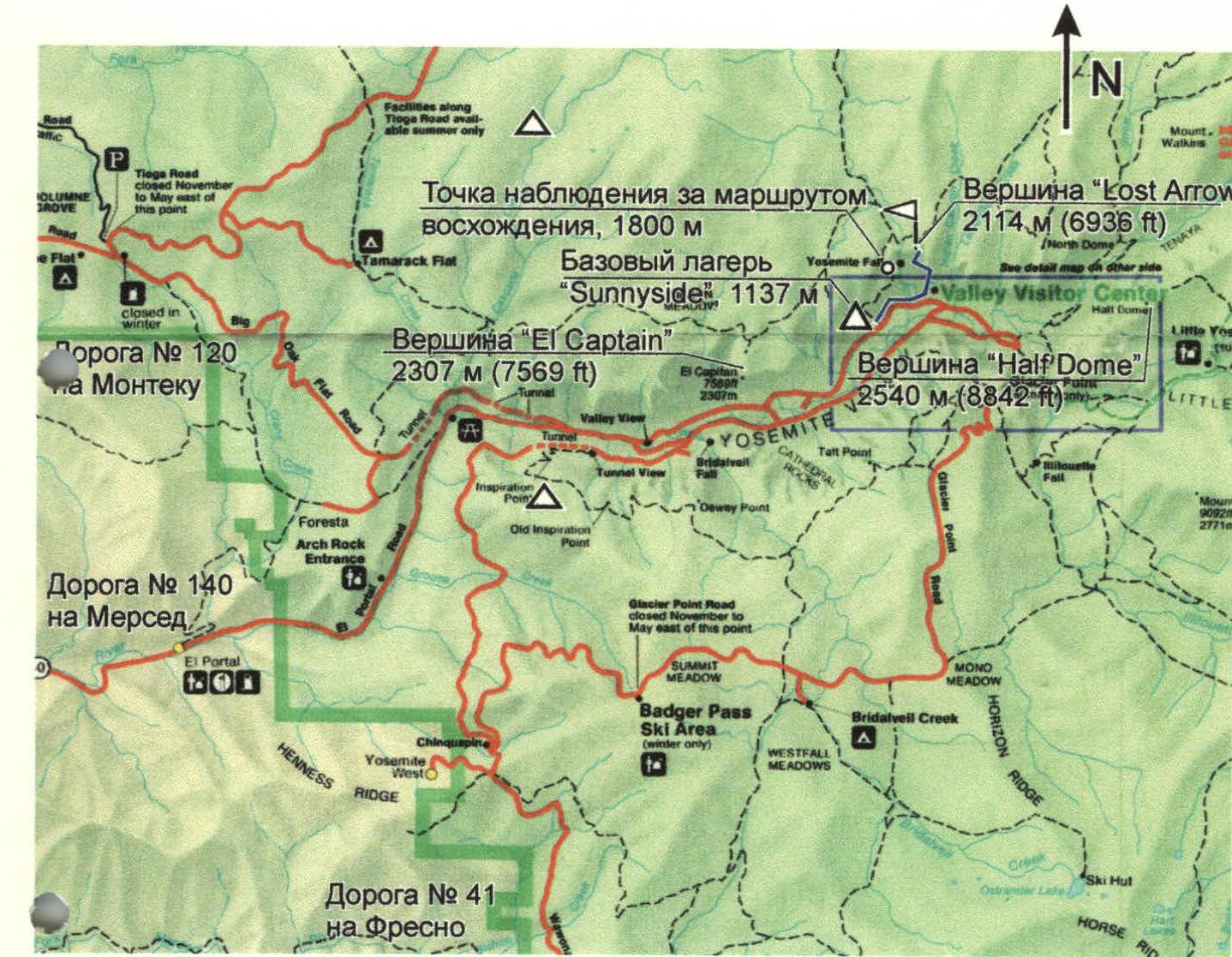
Legend
- ■ Climbing object, "Lost Arrow" summit
- Δ Base camp "Sunnyside"
- ◦ Observation point for the ascent route on the "Top of Yosemite Falls" trail
- Path to the route and return
- Car roads
Hand-drawn profile of the route
