Report on the Ascent of Eiger (3970 m) via the West Flank Route by the "Old Horse" Team on August 3–4, 2019
I. Climbing Report
| №№ | 1. General Information | |
|---|---|---|
| 1.1 | Full name, sports rank of the leader | Yakovlev Evgeny Reinholdovich, 1st sports rank |
| 1.2 | Full name, sports rank of the participants | Stetsenko Vladimir Dmitrievich, CMS; Kruchkovа Tatyana Nikolaevna, 3rd sports rank |
| 1.3 | Full name of the coach | |
| 1.4 | Organization | "Old Horse" club |
| 2. Characteristics of the Climb Object | ||
| 2.1 | Region | Bernese Alps |
| 2.2 | Valley | |
| 2.3 | Section number according to the 2013 Classification Table | 10.3. Alps |
| 2.4 | Name and height of the summit | Eiger, 3970 m |
| 2.5 | Geographical coordinates of the summit (latitude/longitude), GPS coordinates *(1) | |
| 3. Route Characteristics | ||
| 3.1 | Route name | West Flank (West Flank) |
| 3.2 | Proposed category of complexity | 3A (approximately) |
| 3.3 | Degree of route exploration | |
| 3.4 | Nature of the route terrain | Combined |
| 3.5 | Elevation gain of the route (data from altimeter or GPS) | 2320–3970 m |
| 3.6 | Route length (in meters) | 3000 m |
| 3.7 | Technical elements of the route (total length of sections of varying complexity with indication of terrain type: ice-snow, rock) | Category I ice/rock/combination — 1500 m. Category II ice/rock/combination — 1000 m. Category III ice/rock/combination — 400 m. Category IV ice/rock/combination — 100 m. Movement on closed glacier — 0 m. Rappelling 1 section 60 m, divided into 3 descents of 20 m. |
| 3.8 | Descent from the summit | Via the ascent route |
| 3.9 | Additional route characteristics | Lack of water at the bivouac, rock structure — shattered slabs |
| 4. Team Actions Characteristics | ||
| 4.1 | Time on the move (team's walking hours, in hours and days) | 16 hours, 2 days |
| 4.2 | Overnight stays | Site at an altitude of 3000 m |
| 4.3 | Departure onto the route | August 3, 2019 |
| 4.4 | Summit ascent | August 4, 2019 |
| 4.5 | Return to base camp | August 4, 2019 |
| 5. Person Responsible for the Report | ||
| 5.1 | Full name, e-mail | Yakovlev E.R. riso@mail.ru |
*(1) Filled in ONLY if the summit is not listed in the Electronic Russian Classifier of Routes to Mountain Summits
II. Climbing Description
1. Characteristics of the Climb Object
1.1. General photo of the summit (see appendix) 1.2. Photo of the route profile (see appendix)
2. Route Characteristics
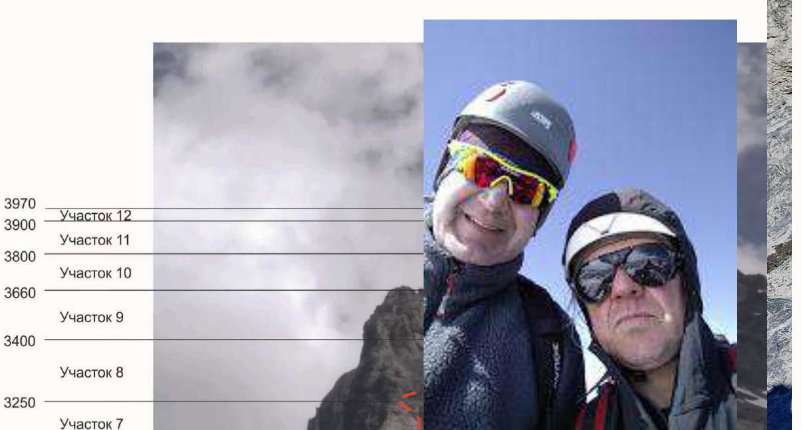
2.1. Technical photograph of the route (see appendix) 2.2. Section numbers on the technical photograph must correspond to the section numbers in paragraph 2.3. 2.3. Technical characteristics of route sections *(5)
| Section # | Terrain characteristics | Category | Length, m | Type and number of hooks |
|---|---|---|---|---|
| 1 | Gentle "ram's foreheads" and scree | 1 | 600 m | – |
| 2 | Steep smoothed rocks | 3 | 200 m | – |
| 3 | Scree | 1 | 300 m | – |
| 4 | Steep, monolithic rocks | 4 | 50 m | Used fixed ropes |
| 5 | Shattered rocks | 1 | 200 m | – |
| 6 | Smooth, gentle rocks | 1 | 400 m | – |
| 7 | Steep monolithic rocks, inner corner | 3 | 50 m | – |
| 8 | Shattered, scree rocks | 2 | 500 m | – |
| 9 | Steep monolithic smooth rocks | 4 | 50 m | Used fixed hooks |
| 10 | Shattered ridge | 2 | 300 m | – |
| 11 | Steep shattered rocks | 3 | 150 m | – |
| 12 | Steep snow ridge | 2 | 200 m |
3. Team Actions Characteristics
3.1. On the morning of August 3, 2019, the team arrived at Eiger Gletscher station. Approximately 2 hours later, they reached the Rotstock location via a trail and simple marked rocks, where the via ferrata from the north begins, and the route actually starts. By mid-day, they reached the bivouac at 3000 m. Before the bivouac — a section of steep, partially vertical rocks with fixed ropes. The bivouac is a good platform, with space for another tent nearby. There is no water at the bivouac, and they had to go about 400 m to the right to a stream. On August 4, 2019, at 7:00, they started on the route. The route was partially familiar, as the team had attempted the ascent 5 years earlier. Then, they had to turn back due to a large amount of snow and worsening weather. Currently, the route conditions were ideal. By around 11:30, they reached a safe, spacious depression under a large rock at the beginning of section 11, where participant Kruchkovа decided to abandon the ascent. Yakovlev and Stetsenko continued the ascent and reached the summit at 12:30. The descent to the bivouac took 5 hours, and another 2 hours to Eiger Gletscher station.
| Section # | Description | Photo # |
|---|---|---|
| Filled in arbitrary form with description of terrain characteristics, direction of movement, landmarks on the route, difficulties, belay methods |
3.2. Photo of the team at the summit near the control tour (see appendix)
3.3. The route is quite long, mostly not very difficult. It mainly passes through smoothed slabs of varying steepness. In bad weather, especially with snowfall, some sections of these slabs can be objectively hazardous. Organizing proper belays on hazardous sections can be problematic due to the rock structure.
The route has the following challenging sections:
- The steepest section (section 4) has fixed ropes, but one part is vertical, so climbers must have corresponding preparation to overcome it.
- Another steep section 9 is equipped with "horn" belay hooks. It features steep, smoothed slabs. If there is snow, this section can be objectively hazardous.
- The final section 12 is a fairly steep snow ridge. It is more interesting psychologically than technically, as it drops off to the North Face on the right. It can be bypassed on the right via steep, shattered rocks, but this requires more time.
The main issue during the route, the team believes, is navigation and choosing the optimal path. There are many trails and cairns on the route, many of which lead away from the desired path, especially during descent. In good visibility, there are no particular problems, but in low visibility, finding the route can become a significant challenge for climbers. We strongly recommend recording the track during ascent.
Helicopter rescue service: 1414 112 — this is a unified phone number for all European Union countries to call in emergency situations. The main function of the 112 service is to provide timely assistance to those in distress within the EU. 112 in Switzerland combines:
- ambulance,
- fire department,
- police.
The call is free. The number works around the clock.
2.1. Technical Photograph of the Route