Report
on the ascent to Mont Blanc du Tacul via the northwest slope, category 2A, by the training group of the "Polytechnic" mountaineering club on August 8, 2018.
I. Ascent Report
| № п.п. | 1. General Information | |
|---|---|---|
| 1.1 | Full name, sports rank of the leader | Alekseev A.A., 1st sports rank |
| 1.2 | Full name, sports rank of the participants | Legkodukhova A.V., 3rd sports rank, Mesh M.V., no rank, Nesterov T.I., no rank, Purtova A.A., no rank, Teslenko K.V., no rank, Cherchashin M.V., 3rd sports rank |
| 1.3 | Full name of the trainer | Molodozhen V.A., Master of Sports |
| 1.4 | Organization | "Polytechnic" mountaineering club |
| 2. Characteristics of the Ascent Object | ||
| 2.1 | Region | Alps |
| 2.2 | Valley | Mont Blanc massif |
| 2.3 | Classification table section number (2013 edition) | 10.3.21a. |
| 2.4 | Name and height of the summit | Mont Blanc du Tacul, 4248 m |
| 2.5 | Geographic coordinates of the summit (latitude/longitude), GPS coordinates | N 45.85651, E 6.88852 |
| 3. Route Characteristics | ||
| 3.1 | Route name | Via the northwest slope (classic route) |
| 3.2 | Proposed category of difficulty | 2A |
| 3.3 | Route освоенности degree | - |
| 3.4 | Route terrain character | Snow and ice |
| 3.5 | Route elevation gain (as per altimeter or GPS data) | 750 m |
| 3.6 | Route length (in meters) | 1750 m |
| 3.7 | Technical elements of the route (total length of sections with varying difficulty, indicating terrain type: ice/snow, rock) | Closed glacier travel — 1700 m, category 2; mixed terrain — 50 m. |
| 3.8 | Descent from the summit | Via the ascent route |
| 3.9 | Additional route characteristics | - |
| 4. Team Actions Characteristics | ||
| 4.1 | Time on the move (team's walking hours, in hours and days) | 4 hours |
| 4.2 | Overnight stays | - |
| 4.3 | Route start time | 04:30 on August 8, 2018 |
| 4.4 | Summit arrival time | 08:30 on August 8, 2018 |
| 4.5 | Return to base camp | 10:30 on August 8, 2018 |
| 5. Report Responsible Person | ||
| 5.1 | Full name, e-mail | Mesh M.V., maxmesh@gmail.com |
II. Ascent Description
1. Characteristics of the Ascent Object
1.1.

General photo of the summit (from www.camptocamp.org↗).
- 1 — route thread
- A, B, C — possible variations depending on conditions
- 2 — continuation of the route towards the main Mont Blanc summit, 4810 m (route "via 3 summits")
1.2 General Description
Mont Blanc du Tacul (4248 m) is a summit in the northern part of the Mont Blanc massif in the French Alps. The mountain has a gentle snow-ice northwest slope. To the south, a rocky ridge extends towards Mont Maudit. To the east, a ridge extends towards Aiguilles du Diable. The classic ascent route follows the snow-ice northwest slope, category 2A (PD by the European system). This ascent is very popular, used either as a standalone climb or as an acclimatization climb for the main Mont Blanc summit. Typical summer air temperatures at base camp altitude are around +10 °C during the day and around zero at the summit. Nighttime temperatures at base camp are approximately 0 to -5 °C. First ascent: Charles Hudson et al., August 8, 1855. The ascent was conducted as part of a training camp by the "Polytechnic" mountaineering club, St. Petersburg.
1.3 Area Map
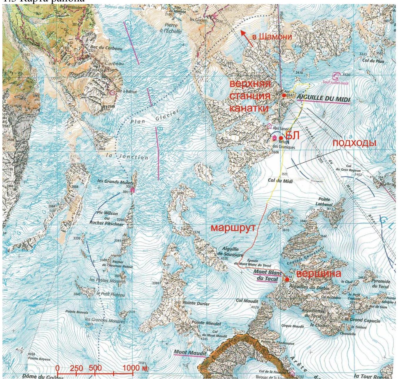
1.4. Base camp is set up on the Col du Midi plateau, below the Cosmique hut. Overnight stay is also possible in the hut (approximately 60 euros in 2018). To reach base camp: take the Aiguille du Midi cable car from Chamonix center to the top station (3842 m). Exit the station through the tunnel for climbers (there is only one). Then descend the snow-ice ridge (up to 30 °, 500 m) to the plateau. On the plateau, head south for 500 m to the tent camp below the Cosmique hut. The camp is at an altitude of approximately 3500 m. Total descent time from the station to base camp is within 1 hour. The approach to the route from base camp is southward along the broad saddle (plateau) of Col du Midi — 1 km, 0.5 hours.
2. Route Characteristics
2.3 Technical Characteristics of Route Sections
| Section № | Terrain Character | Category of Difficulty | Length, m | Type and Number of Pitons |
|---|---|---|---|---|
| 1 | Snow-ice slope 30–35 ° | 2–3 | 1200 | - |
| 2 | Snow-ice shoulder, 10 ° | 1 | 500 | - |
| 3 | Rocky summit tower | 2 | 50 | - |
3. Team Actions Characteristics
3.1 Brief Description of Route Passage
| Section № | Description | Photo № |
|---|---|---|
| R0–R1 | Snow-ice slope 30–35 °. Movement in rope teams on a closed glacier with a well-trodden path. Bergschrund (point 1 on photo 1) is crossed via a fixed ladder about 7 m long. | 1,2 |
| R1–R2 | Snow-ice shoulder, 10 °. Movement on a path in rope teams. | 1,3 |
| R2–R3 | Rocky summit tower, ascent to the left of the direction of travel. Protection via terrain; no placements required. | 3 |
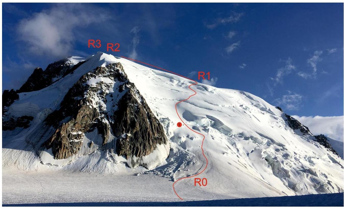
Photo 1. General view of the route from base camp. Taken on August 8, 2018, from BC. The summit (R3) is hidden behind a large snow ridge.
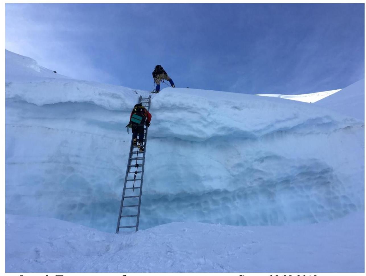
Photo 2. Crossing the bergschrund via ladder. Taken on August 8, 2018, on descent from the summit.
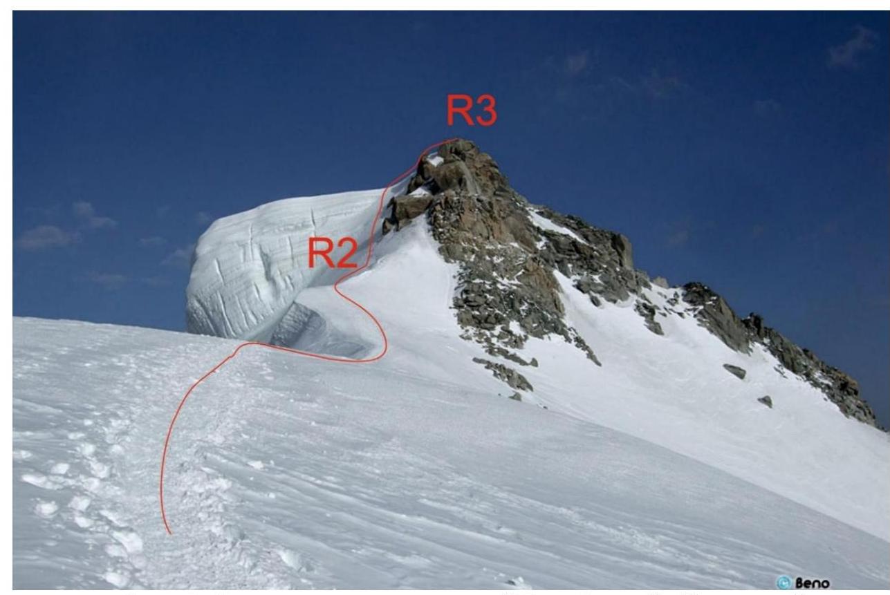
Photo 3. View of the summit from the shoulder (R2 on photo 1) (from www.camptocamp.org↗).
3.2.
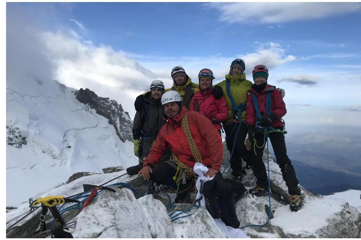
Photo 4. Team at the summit.
3.3. The route is threatened by hidden crevasses. Movement is in rope teams. Descent is via the ascent route. In case of reduced visibility or snow covering the path, it is recommended to record a track during ascent.
- The entire group moved in rope teams simultaneously.
- All participants wore crampons.
- Mobile phone reception was stable throughout the route.


