
Report
On the ascent of the CSKA Demchenko team to the summit of Gran Paradiso (4061 m) via the N wall, 4B cat. diff., Graian Alps, Valle d'Aosta region, Gran Paradiso National Park
Leader: N.V. Turbin
Senior coach: E.V. Kuznetsova
Ascent Details
-
Graian Alps (Italy). Gran Paradiso area. No. 10.3 (according to KGVB 2011)
-
Gran Paradiso peak 4061 m via N wall (first ascent by C. Bertolone, F. Cappa, G. Giorda, 1958)
-
Proposed category: 4B cat. diff.
-
Route type: snow-ice
-
Elevation gain: 500 m
Route length: 800 m.
Average slope:
— main part of the route — 60° — entire route — 55°
-
Pitons left on the route:
Total — —; including bolted pitons — —
-
Team's climbing hours: 6 hours (not including descent)
-
Leader: Turbin N.V. 2nd sports category
Team members:
— Bonchuk A.N. 2nd sports category — Shcheglov I.E. 2nd sports category — Popov A. 2nd sports category
-
Coach: Kuznetsova E.V.
-
Departure from base camp:
Route started: 8:00, July 4, 2012 Summit reached: 14:00, July 4, 2012 Return to base camp: 17:00, July 4, 2012 Descent from the summit: via the ascent route to Chabot hut;
-
Organization: CSKA Demchenko training camp (Moscow)
-
Report responsible: Shcheglov I.E., A.V. Yurkin.
Email: format_d@mail.ru, S2_aleks@mail.ru
General photo of the summit.
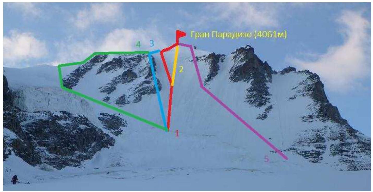
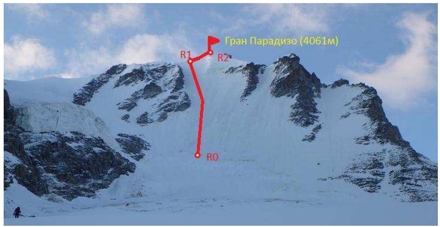
Photo of Gran Paradiso peak. Taken from Laveciau glacier on July 4, 2012.
Routes on Gran Paradiso peak:
- route via N wall (C. Bertolone, F. Cappa, G. Giorda, 1958)
- route via N wall (variation) direttissima
- route via N wall and N ridge (A. Crétier, L. Bon, Renato Chadod, 1930)
- route via NE ridge (E. Jevelle, 1860)
- route via N wall and NW ridge
Panorama of the area
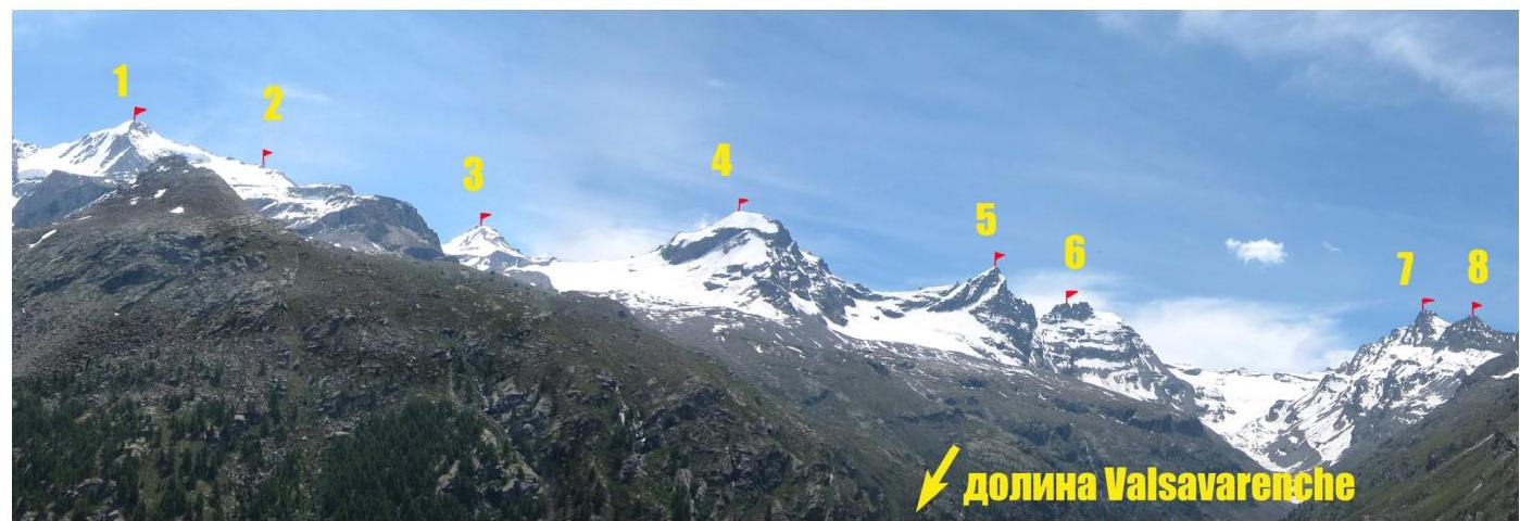
Photo taken from the vicinity of Pont village
Overview of Gran Paradiso area
Peak labels (with elevations) on the map:
- Punta Galisia 3346 m
- Punta Basei 3338 m
- Punta Gran Vaudala 3272 m
- Taou Blanc 3438 m
- Aouillé 3440 m
- Cima di Entrelor 3430 m
- Punta Percià 3227 m
- La Roletta 3384 m
- Punta Bianca 3427 m
- Punta Bioula 3414 m
- Punta del Ran 3272 m
- Punta Chamoussière 2942 m
- Monte Paillasse 2414 m
- Cima dell'Arolley 2996 m
- Cima di Seiva 3075 m
- Punta Fourà 3411 m
- Mare Pèrcia 3385 m
- Denti del Broglio 3454 m
- Becca di Monciair 3544 m
- Ciarforon 3642 m
- La Tresenta 3609 m
- Becca di Moncorvè 3875 m
- Gran Paradiso 4061 m
- Piccolo Paradiso 3923 m
- Becca di Montandayné 3838 m
- Herbetet 3778 m
- La Gran Serra 3552 m
- Punta Rossa della Grivola 3630 m
- La Grivola 3969 m
- Grivoletta 3514 m
- Gran Nomenon 3488 m
- Mont Favret 3173 m
- Punta Valletta 2793 m
- Becca Piana 2271 m
- Punta Ceresole 3777 m
- Testa della Tribolazione 3642 m
- Testa di Valnontey 3562 m
- Becca di Gay 3621 m
- Becco Meridionale della Tribolazione 3360 m
- Roccia Viva 3650 m
- Torre del Gran San Pietro 3692 m
- Punte Patri 3581 m
- Punta Valletta 3356 m
- Punta di Valmiana 3244 m
- Punta Fenilia 3053 m
- Punta d'Ondezana 3452 m
- Becco di Valsoera 3369 m
- Punta delle Sengie 3408 m
- Monveso di Forzo 3322 m
- Grande Arolla 3246 m
- Punta della Tsesère 3117 m
- Torre di Lavina 3308 m
- Punta di Acque Rosse 2952 m
- Punta Nera 3064 m
Approach route from base camp (Pont village campsite) to Chabot hut

Gran Paradiso peak (4061 m), the target of the ascent, is located in the Gran Paradiso National Park. The park is situated in the Graian Alps, in the autonomous region of Valle d'Aosta, northern Italy. The highest point in the Gran Paradiso area is 4061 m, the seventh highest peak in the Alps (Mont Blanc being the first). The Valle d'Aosta region is dominated by mountains, featuring iconic Italian and Alpine peaks such as Monte Bianco (Mont Blanc), Gran Jorasses, Cervino (Matterhorn), and Gran Paradiso. Most interesting mountaineering routes are found in the Gran Paradiso ridge. With peak elevations between 3500–4000 m, the area offers diverse terrain, including rocks, ice, and snow, with many combined routes. Routes range from 1st to 4th category difficulty, with some 5th category routes. The ascent to Gran Paradiso was part of the CSKA Demchenko training camp (Moscow) in June-July 2012. The base camp was set up in the Pont village campsite, the highest and last settlement in the Valsavaranche valley, at an elevation of 1950–2000 m. The route was accessed from Chabot hut (2750 m). The approach followed a convenient trail from Pont village, taking 2–2.5 hours. An alternative approach is possible from Previeux (1.5 km below Pont), following a marked trail.
Gran Paradiso peak is situated between Piccolo Paradiso (3923 m) and Becca di Moncorvè (3875 m). The summit coordinates are 45°31′6.25″ N 7°16′1.19″ E. In the Italian classification, the route via the N wall is rated D.
Route description
| Section | Length, m | Angle, ° | Terrain | Category | Pitons |
|---|---|---|---|---|---|
| R0–R1 | 600 | 50–60 | Ice | IV | |
| R1–R2 | 200 | 20–30 | Snow ridge | II |
Technical photo of the route
Brief description of the route
The approach to the route was made from Chabot hut. The team followed a trail, then traversed gentle rocky "ram's foreheads" towards Laveciau glacier. Caution is advised on the glacier due to crevasses. The team approached the N wall via the gentle part of the glacier, under a large bergschrund. The journey from the hut took 1.5–2 hours.
R0–R1. The bergschrund was crossed at its middle part. From there, the team ascended vertically up the ice, bypassing overhanging ice on the left, and reached the NW ridge.
R1–R2. The team followed the sharp ridge to the right, towards the summit (rocks and ice). Caution is advised due to cornices.
The descent followed the classic 1B route. The descent took 1–1.5 hours. The route is considered safe.
Photo illustrations
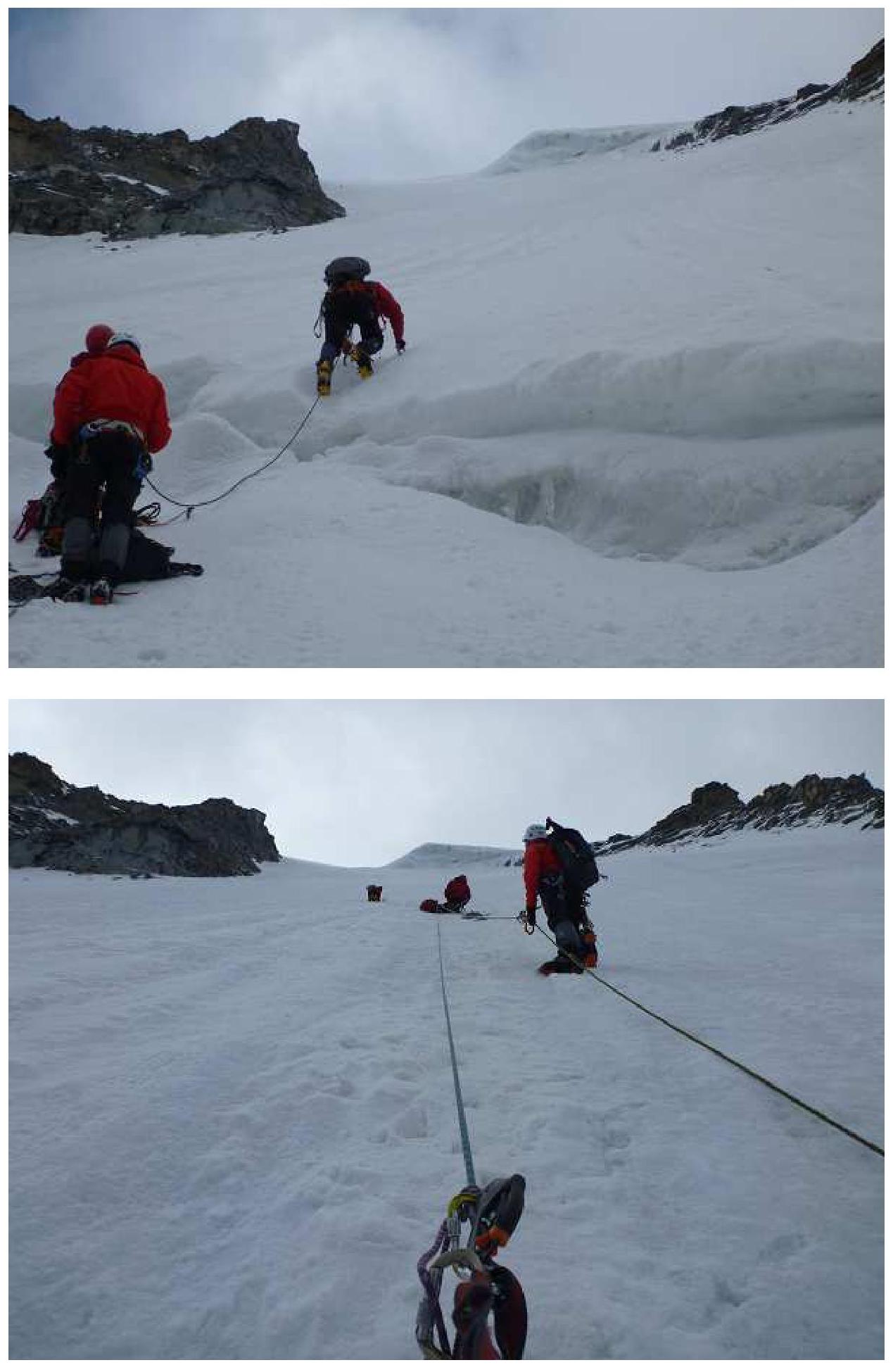
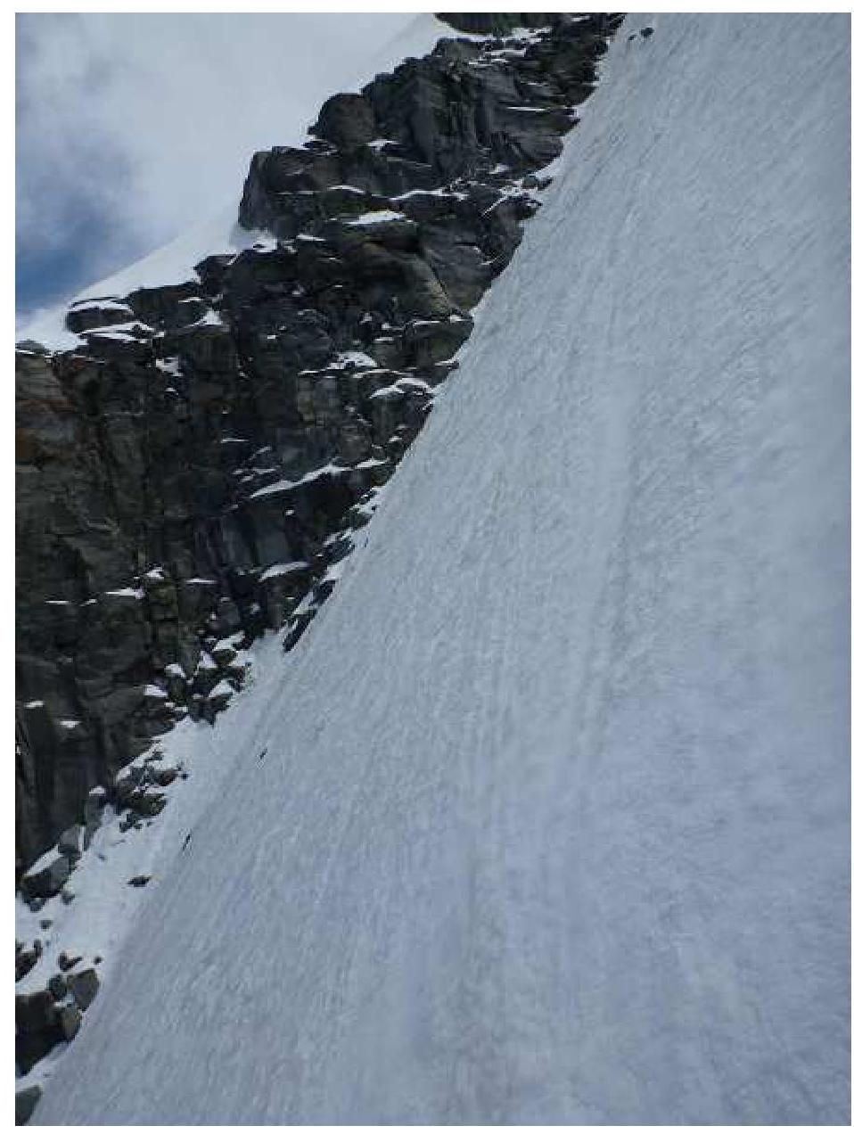
Photos of section R0–R1
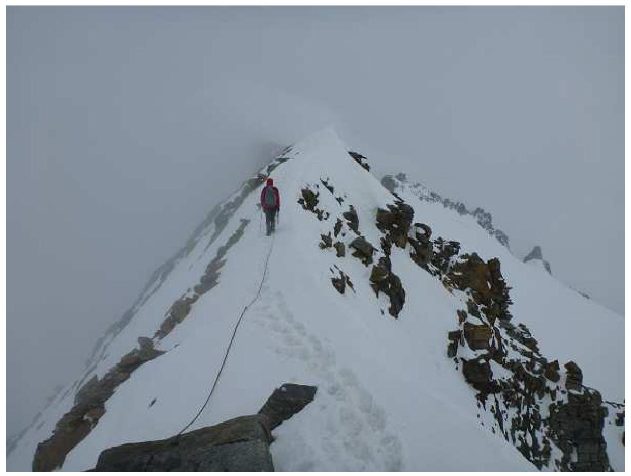
Photo of section R1–R2
A photo of the team at the summit is missing due to deteriorating weather conditions, with a thunderstorm forcing the team to descend quickly after reaching the summit.
Comments
Sign in to leave a comment