

Report
On the ascent of the CSKA team named after Demchenko to the summit of Gran Paradiso (4061 m) via the NW ridge, 3B cat. difficulty, Graian Alps, Valle d'Aosta region (Valle d'Aosta), Gran Paradiso National Park.
Team leader: E. V. Korol
Senior coach: E. V. Kuznetsova
Ascent Details
-
Italy. Graian Alps, Valle d'Aosta region (Valle d'Aosta) Gran Paradiso National Park. Section No. 10.3 (according to KGBM 2011)
-
Gran Paradiso peak (Gran Paradiso) 4061 m via the Northwest ridge
-
Proposed category: 3A(B) cat. difficulty
-
Route type: combined
-
Route elevation gain: 800 m Route length: 1500 m. Section lengths: — V cat. difficulty — m. — VI cat. difficulty — m.
Average steepness: main part of the route – 55°, entire route – 22°.
-
Pits left (used) on the route: total 18; including bolted —
-
Team's total climbing hours: 9.5 hours, not including descent
-
Team leader: Korol Evgeny, Master of Sports
Team members:
| Gakharia Anna | 3 |
|---|---|
| Sokolova Tatyana | 3 |
| Son Igor | 3 |
| Khvalkovsky Nikolai | 3 |
- Coach: Kuznetsova E.V.
- Departure from Base Camp to the route: 3:15 AM July 7, 2012 Route started: 5:00 AM July 7, 2012 Summit reached: 2:30 PM July 7, 2012 Return to Base Camp: 5:15 PM July 7, 2012 Descent from the summit: via 1B cat. difficulty to Vittorio Emanuele II hut
- Organization: CSKA training camp named after Demchenko (Moscow)
- Responsible for the report: Khvalkovsky N., A.V. Yurkin. Email: n.khvalkovskiy@gmail.com
General Summit Photo
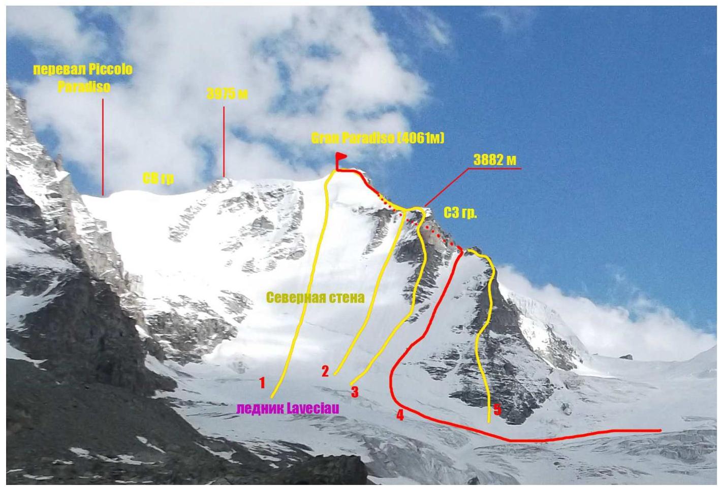
Gran Paradiso peak (4061 m). Photo taken from the Laveciau glacier moraine. Routes:
- Route via N face 4B cat. difficulty (D) (C. Bertolone, F. Cappa, G. Giorda, 1958)
- Route via N face and NW ridge (variation)
- Route via N face and NW ridge through elevation 3882 m (F. Locatelli+6, 1974)
- Team's route
- Route via NW ridge
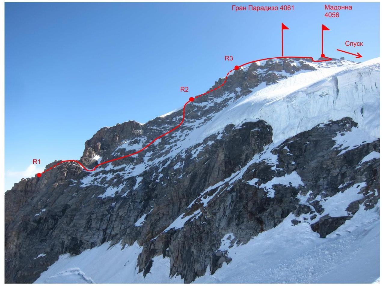
Route Profile Photo
Area photopanorama.
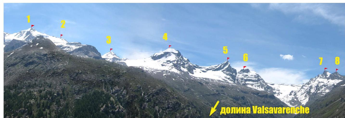
Route labels:
- Gran Paradiso peak 4061 m
- Becca di Moncorvè peak 3875 m
- La Tresenta peak 3609 m
- Ciarforon peak 3642 m
- Becca di Monciair peak 3544 m
- Denti del Broglio peak 3454 m
- Mare Pércia peak 3385 m
- Punta Fourà peak 3411 m
Area Map

| Peak labels (with elevations) on the map: | |
|---|---|
| 1. Punta Galisia 3346 м | 28. Punta Rossa della Grivola 3630 м |
| 2. Punta Basei 3338 м | 29. La Grivola 3969 м |
| 3. Punta Gran Vaudala 3272 м | 30. Grivoletta 3514 м |
| 4. Taou Blanc 3438 м | 31. Gran Nomenon 3488 м |
| 5. Aouillé 3440 м | 32. Mont Favret 3173 м |
| 6. Cima di Entrelor 3430 м | 33. Punta Valletta 2793 м |
| 7. Punta Percià 3227 м | 34. Becca Piana 2271 м |
| 8. La Roletta 3384 м | 35. Punta Ceresole 3777 м |
| 9. Punta Bianca 3427 м | 36. Testa della Tribolazione 3642 м |
| 10. Punta Bioula 3414 м | 37. Testa di Valnontey 3562 м |
| 11. Punta del Ran 3272 м | 38. Becca di Gay 3621 м |
| 12. Punta Chamoussière 2942 м | 39. Becco Meridionale della Tribolazione 3360 м |
| 13. Monte Paillasse 2414 м | 40. Roccia Viva 3650 м |
| 14. Cima dell'Arolley 2996 м | 41. Torre del Gran San Pietro 3692 м |
| 15. Cima di Seiva 3075 м | 42. Punte Patri 3581 м |
| 16. Punta Fourà 3411 м | 43. Punta Valletta 3356 м |
| 17. Mare Pércia 3385 м | 44. Punta di Valmiana 3244 м |
| 18. Denti del Broglio 3454 м | 45. Punta Fenilia 3053 м |
| 19. Becca di Monciair 3544 м | 46. Punta d'Ondezana 3452 м |
| 20. Ciarforon 3642 м | 47. Becco di Valsoera 3369 м |
| 21. La Tresenta 3609 м | 48. Punta delle Sengie 3408 м |
| 22. Becca di Moncorvè 3875 м | 49. Monveso di Forzo 3322 м |
| 23. Gran Paradiso 4061 м | 50. Grande Arolla 3246 м |
| 24. Piccolo Paradiso 3923 м | 51. Punta della Tsesère 3117 м |
| 25. Becca di Montandayné 3838 м | 52. Torre di Lavina 3308 м |
| 26. Herbetet 3778 м | 53. Punta di Acque Rosse 2952 м |
| 27. La Gran Serra 3552 м | 54. Punta Nera 3064 м |
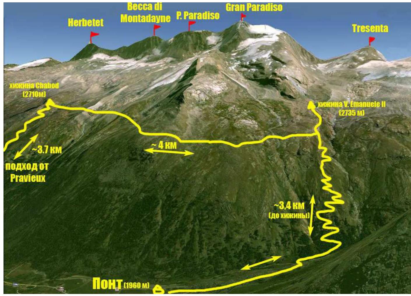
Approach route map from Base Camp (Pont campsite) to Vittorio Emanuele II hut and Chabod hut.
Gran Paradiso – 4061 m, the summit climbed, is located within the Gran Paradiso National Park. The park is situated in the Graian Alps mountain range in the autonomous region of Valle d'Aosta in northern Italy. Gran Paradiso is the highest peak in the area and is the seventh highest peak in the Alps (Mont Blanc being the first).
The Valle d'Aosta region is heavily mountainous. It is home to some of the most iconic Italian and Alpine peaks, including Monte Bianco (Mont Blanc), Grand Jorasses, Cervino (Matterhorn), among others.
Most mountaineering routes of interest are located in the Gran Paradiso mountain range. With peak elevations between 3500–4000 m, the area features a variety of terrain including rocks, ice, snow, etc. There are numerous combined routes. The majority of routes fall within the 1st to 4th category of difficulty, with some 5th category routes present.
The ascent to Gran Paradiso was part of the CSKA training camp named after Demchenko (Moscow) held in June and early July 2012. The Base Camp was set up in the Pont campsite (Valsavaranche valley). Pont is the highest and last settlement in the Valsavaranche valley, with an elevation of 1950–2000 m.
The route started from the Vittorio Emanuele II hut. The hut is located at the foot of Gran Paradiso at an elevation of 2732 m. The approach from Pont to the hut follows a convenient trail and takes about 2 hours.
The route via the NW ridge (classified as AD+ in the Italian grading system) was assessed as 3B cat. difficulty.
Technical Route Photo
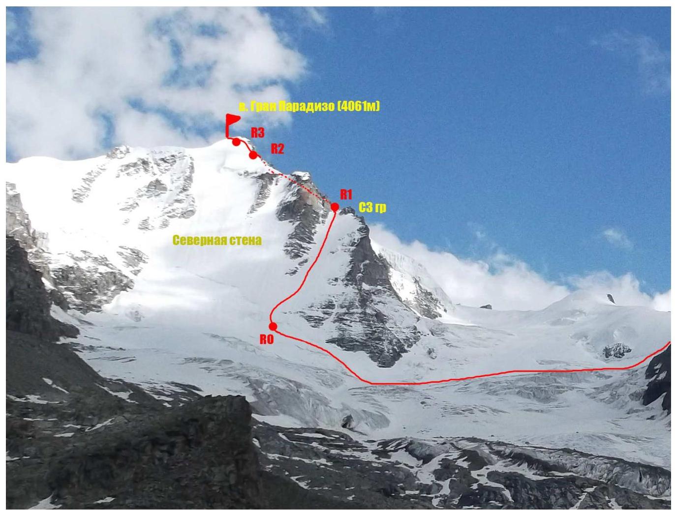
| Section | Length | Steepness | Terrain Description | Category of Difficulty | Number of Pits |
|---|---|---|---|---|---|
| R0–R1 | 150 м | 15–40° | Snow, firn, ice | 2 | 9 |
| R1–R2 | 400 м | 30–40° | Rocky and scree slope, partially covered with snow, with some sections of frozen ice. | 3 | 7 |
| R2–R3 | 100 м | 30°, last 10 m — up to 80° | Wide snow and ice ridge | 3 | 0 |
| R3–R4 | 400 м | 10–15°, short sections — up to 90° | Narrow snow and ice ridge, small rock formations (gendarme) covered with snow, rocky walls | 2 | 2 |
Brief Description of Route Sections
Approach:
From Vittorio Emanuele II hut, follow a marked trail 400 m to a stream flowing from the Gran Paradiso glacier. Cross the stream and ascend to a high moraine ridge (left of the stream). A good trail follows the ridge to a rocky wall (30 m, easy rocks, with rappel rings). The trail then traverses along the edge of the rocks and leads to a gently sloping plateau. Move across the plateau towards Gran Paradiso peak (Photo 1). The ascent from the hut to the edge of the plateau near the start of the route takes about 1.5 hours. It's advisable to put on crampons before descending onto the glacier. A broken section is bypassed on the right.
Continue across the gentle, crevassed glacier to approach the snow and ice slope on the left side of the NW ridge. The slope's steepness is 15–20°. Traverse 500–600 m. Be cautious of hidden crevasses!
R0–R1 — Ascend from the bergschrund. Rock outcrops are bypassed on the left. The slope steepens to 30° in the middle section. Protection via ice screws or on rocks to the left. The exit to the ridge is onto a snow saddle to the right (ice up to 40°) (Photos 2, 3).
R1–R2 — From the saddle, move along the rocky and snowy ridge to a rocky wall (30 m). The wall is bypassed on the right, initially via ledges. Then traverse a snowy, rocky, and scree slope (with some frozen ice sections) (300 m), with protection via natural features, friends, and rock pitons. Continue directly upwards for 60 m, on rocks of 2–3 cat. difficulty, up to 50° — exit onto a snow and ice ridge.
R2–R3 — The initial steep ascent (100 m, up to 80° at the top) is tackled head-on.
R3–R4 — Continue along a gentle, not very wide ridge. Be aware of potential cornices towards the Gran Paradiso glacier. Identifying the highest point of the ridge can be challenging; traditionally, the summit is considered to be the rocky outcrop with the Madonna statue (4052 m). A rocky gap in the ridge before the summit (6 m wall, 90°) is bypassed on the left, with rappel rings available. Traverse the rocky summit to the right via a ledge and ascend via the SE ridge (bolted protection) — 10 m, II+ cat. difficulty (coincides with the 1B cat. difficulty route).
Descent from the summit follows the 1B cat. difficulty route.
- The choice of route on sections R0–R1 heavily depends on the condition of the route (snow – firn – frozen ice).
- It's possible to exit onto the ridge just after the rocky bastion (Photo 4) via a rocky and scree slope (150 m, up to 45°), but this involves an additional snow and ice ascent on the ridge, where protection can be challenging (firn, hard to reach the ice).
- Using stoppers and hexes is difficult due to the predominantly widening crevasses.
Photo Illustrations
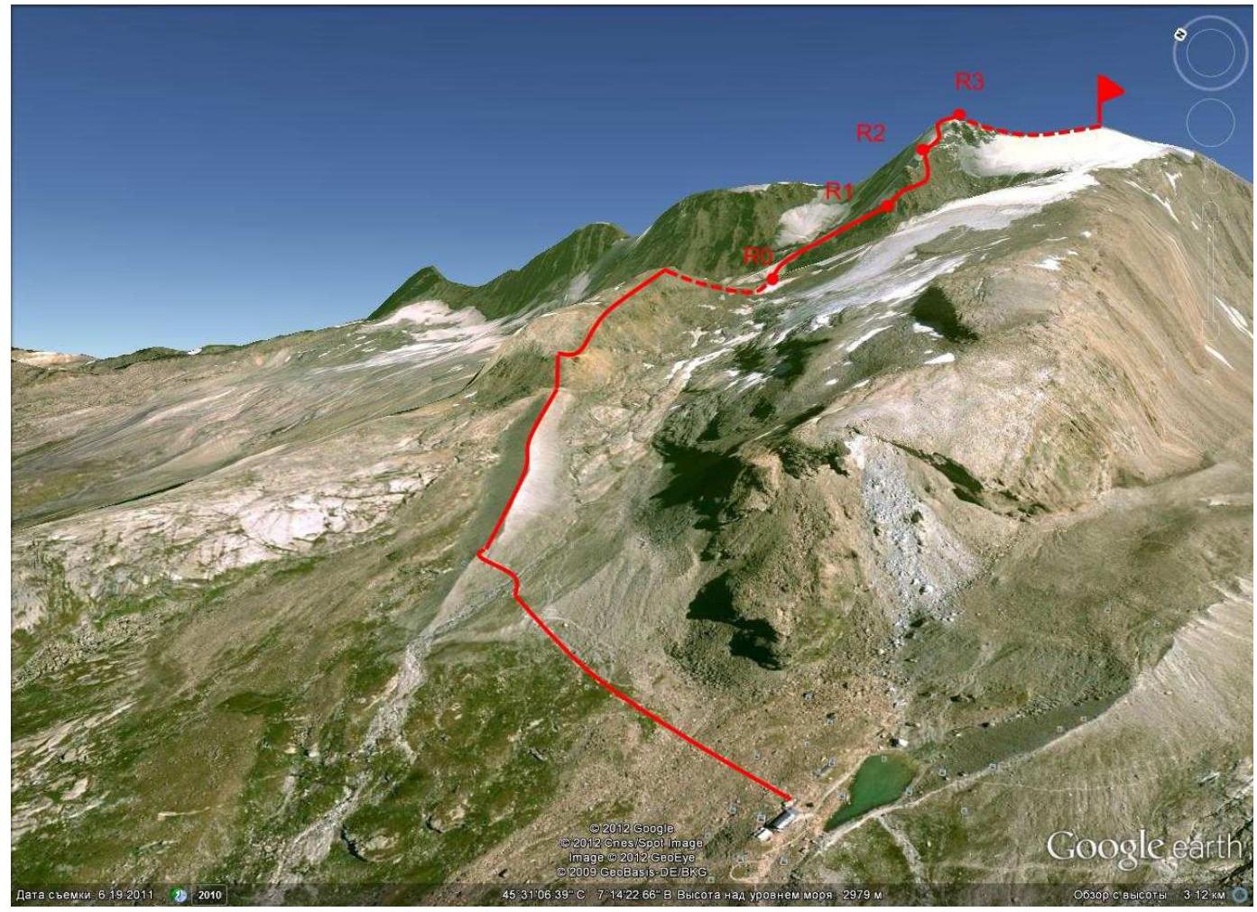
Photo 1. Approach from Vittorio Emanuele II hut
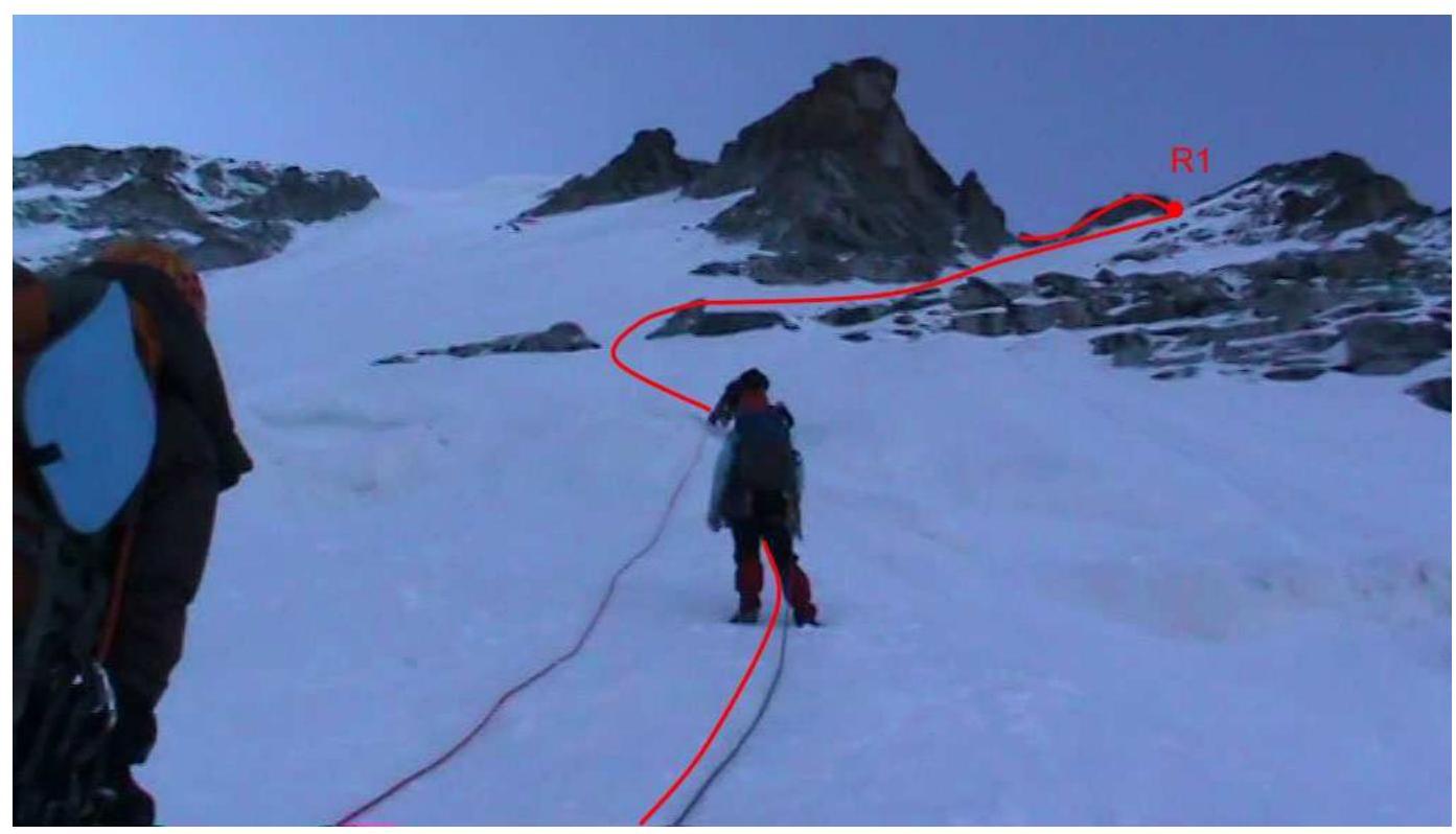
Photo 2. Section R0–R1. Snow and ice slope after the bergschrund.
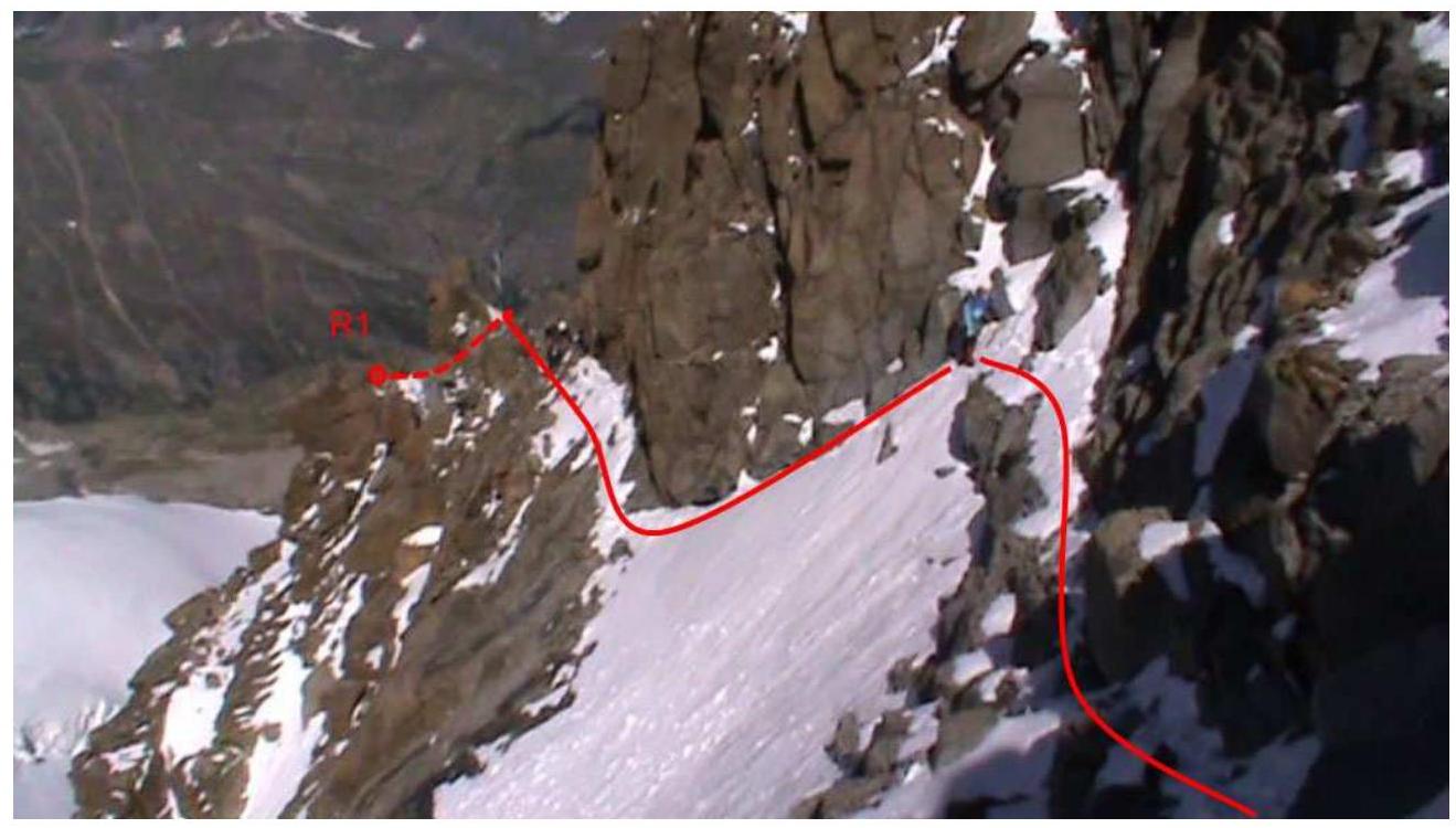
Photo 3. Section R1–R2. Right side of the NW ridge.
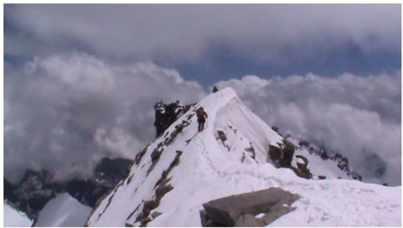
Photo 4. Section R3–R4. Upper part of the ridge.
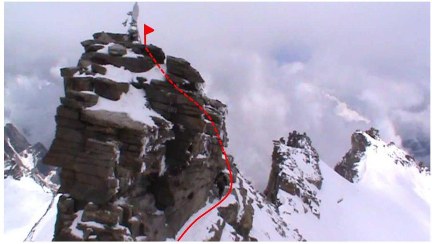
Photo 5. Summit photo — Madonna statue.
Comments
Sign in to leave a comment