
Report
On the ascent of the KAiS MEI team to the summit of Gran Paradiso (4061 m) via the North Face and Northwest Ridge, category 3B. Graian Alps, Valle d'Aosta region (Valle d'Aosta) Gran Paradiso National Park
Leader: Toporkov A.V.
Senior Coach: Korochkov A.S.
Climbing Passport
-
Italy. Graian Alps, Valle d'Aosta region (Valle d'Aosta) Gran Paradiso National Park. Section 10.3 of the mountain peak route classifier
-
Gran Paradiso peak (4061 m) via the North Face and Northwest Ridge
-
Category 3B, ice and snow terrain
-
Elevation gain of the main part of the route: 300 m, total route: 400 m Route length: 870 m. Length of sections: V category — m, VI category — m.
Average slope:
- main part of the route (up to the Northwest Ridge) — 40°
- total route — 20°
-
Number of pitons used on the route: 35
-
Team's total climbing time from Chabod Hut: 10 h 30 min, not including descent; from the start of the route: 7 h 30 min.
-
Leader: Toporkov Alexander (Candidate for Master of Sports, instructor 3rd category)
Participants:
- Antipina Natalia (3rd sports category)
- Tretyakova Vera (3rd sports category)
- Ovcharenko Irina (3rd sports category)
- Afanasyeva Lena (3rd sports category) Coach: Korochkov Alexey Semyonovich
-
Departure from the bivouac (Chabod Hut): July 31, 2018, at 3:00 AM
Start of the route (bergschrund): 6:30 AM. Reaching the Northwest Ridge: 11:30 AM. Summit: 1:30 PM. Descent from the summit: via category 1B route to Chabod Hut
-
Alpine event: Training and Climbing Camp (UTS and KS) KAiS MEI Alps 2018
-
Responsible for the report: Toporkov A.V., email: toporchillo@gmail.com
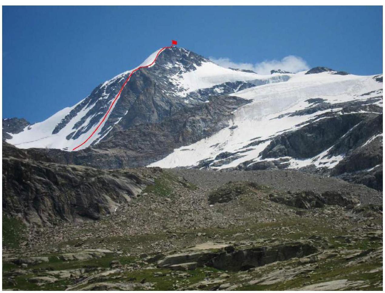
General Summit Photo

- Gran Paradiso from Piccolo Paradiso Pass and Northeast Ridge
- Gran Paradiso via North Face, 4B (S. Bertolone, F. Cappa, G. Giorda, 1958)
- Gran Paradiso via North Face and Northwest Ridge (team's route)
- Gran Paradiso via North Face and Northwest Ridge (F. Locatelli+6, 1974)
- Gran Paradiso via Northwest Ridge, 3B
- Gran Paradiso via Northwest Ridge
The photograph was taken from Chabod Hut
Technical Photograph of the Route
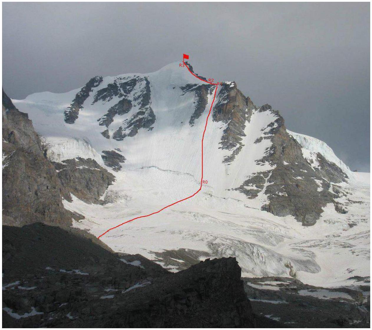
The photograph was taken from Chabod Hut. The summit itself is not visible. The North Ridge lies between the visible highest point and the summit.
| Section | Length | Slope | Terrain Characteristics | Category | Number of Protection Points |
|---|---|---|---|---|---|
| R0–R1 | 500 m | 40 | snow and ice | 3 | 32 ice screws |
| R1–R2 | 20 m | 15 | rocks | 1 | - |
| R2–R3 | 250 m | 25 | snowy ridge | 1–2 | - |
| R3–R4 | 100 m | 25 | snowy ridge | 1 | - |
| R5–R6 | 100 m | 30 | rocky ridge | 1–3 | 2 slings |
Route Profile Photo
Brief Description of the Route by Sections
Approach: From Chabod Hut, follow the trail upwards for 100 m, then traverse a steep slope, reach a stream, cross it via a bridge, and continue on the trail towards the moraine ridge. Ascend the moraine ridge to the glacier (1.5 hours).
On the glacier, move in teams towards the Gran Paradiso wall, in the direction of the ice and snow slope between two rocky buttresses. The glacier is closed, with crevasses. Approach the bergschrund and cross it via a snow bridge (3.5–4 hours). (Photo 1)
R0–R1: Ice slope 600 m between two rocky buttresses. Slope 40°, 32 ice screws used. Reach the Northwest Ridge: 5 hours (Photo 2)
R1–R2: Simple rocky ridge: 20 m, 15°. (Photo 3)
R2–R3: Snowy ridge: 150 m, 20°. The ridge ends with a snow cornice, which should be bypassed on the right; 1 ice screw used.
R3–R4: Snowy ridge: 100 m
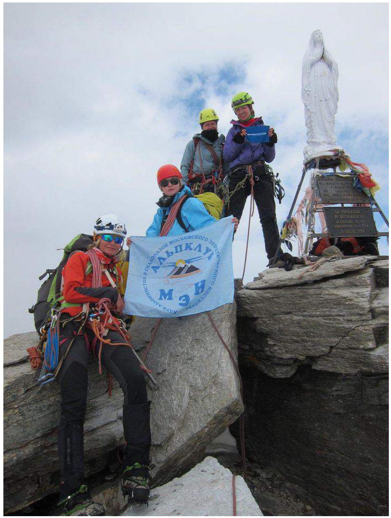
R5–R6: Rocky ridge with a summit gendarme. Ascend the summit gendarme via ledges from the south — it is gentler there, with existing fixed protection points. At the summit, there is a statue of the Madonna (Photo 4).
Descent from the summit via a category 1B route to Chabod Hut — 3.5 hours.
Note: On July 31, the sun illuminates the Northwest Ridge at 10:00 AM. Rockfall is possible from the rocky buttresses between which the route passes.
On the day of our ascent, the route was in near-ideal condition: the bergschrund was crossed via a snow bridge, and the lower part of the route was an ice slope covered with a thin layer of snow. This allowed for easy movement on snow and reliable protection on the ice beneath the snow.
In terms of technical difficulty, the route surpasses routes such as:
- Izyiskatel Peak via Northwest Face, 3B
- Comparable to the route on Djailyk via the South slope of the 3rd ridge, 4A
- Less difficult than the route to Korona 1 peak via the ice wall, 3rd category, 4A
Photo Illustrations for the Report
Photo 1: Snowy slope above the bergschrund

Photo 2: Ice and snow slope R0–R1

Photo 3: Rocky ridge R1–R2, snowy ridge R2–R3 visible
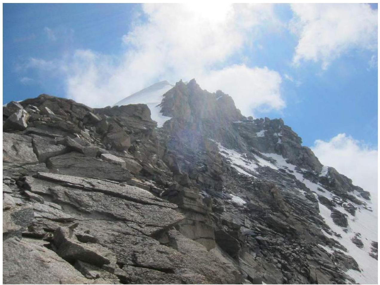
Photo 4: Summit
Comments
Sign in to leave a comment