ASCENT REPORT (6B variation)
- Region — Alps, 10.3.
- Peak — Gранд Жораcc (Grand Jorasses), Croz peak, 4110 m via the center of the north face.
- Proposed route — 6B category of difficulty (ED VI+, 6b, A2), variation of route № Siesta.
- Route type — combined.
- Route characteristics: elevation gain — 1030 m, route length — 1200 m, sections of 6th category — 650 m, 5th category — 300 m, average steepness of the wall section — 72°.
- Left on the route: pitons — 13, including bolted — 9; " закладок" — 2.
Pitons used on the route:
bolted stationary — 9, including for platform setup — 3; total ITC used — 399.
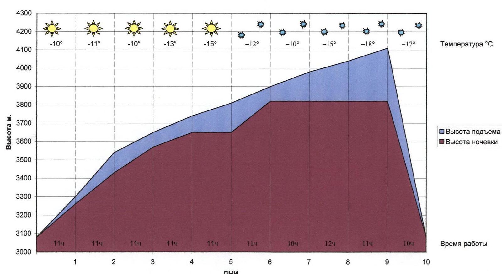
- Climbing hours — 109, days — 9.
- Team leader — Khvostenko Oleg Valerievich, MS Team members: Pugovkin Anton Nikolaevich, MS, Litvinov Andrey Dmitrievich, MS, Tsygankov Viktor Anatolievich, MS
- Team coaches: Zakharov Nikolai Nikolaevich, MSMK, ZTR Balezin Valery Viktorovich, MSMK
- Dates: departure — February 10, 2006, 9:00, summit — February 18, 2006, 15:00, return — February 19, 2006, 19:00.
- Organization: Krasnoyarsk Regional Committee for Physical Education and Sports
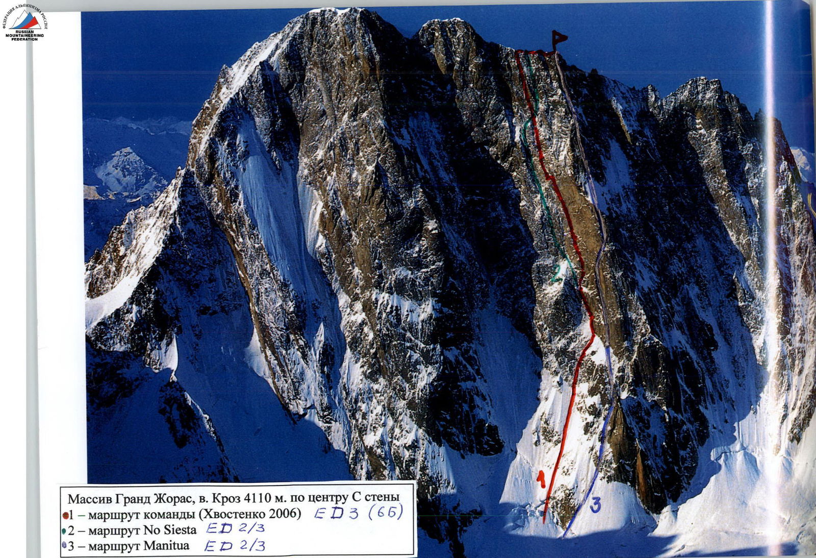
 Gранд Жораcc massif, Croz peak 4110 m via the center of the north face.
- 1 — team route (Khvostenko 2006) ED 3 (6B)
- 2 — route № Siesta ED 2/3
- 3 — route Manitua ED 2/3
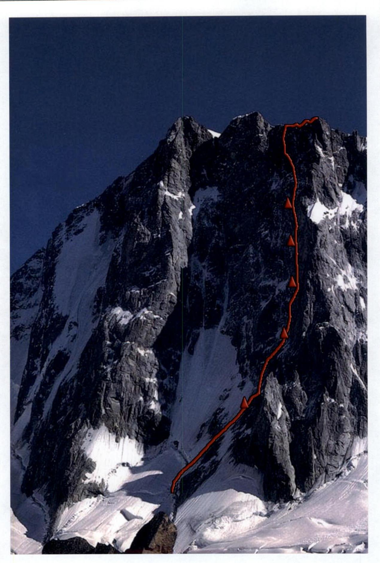
Route profile on the right. Photo from www.mountain.ru↗
Movement Graph
UIAA Scheme
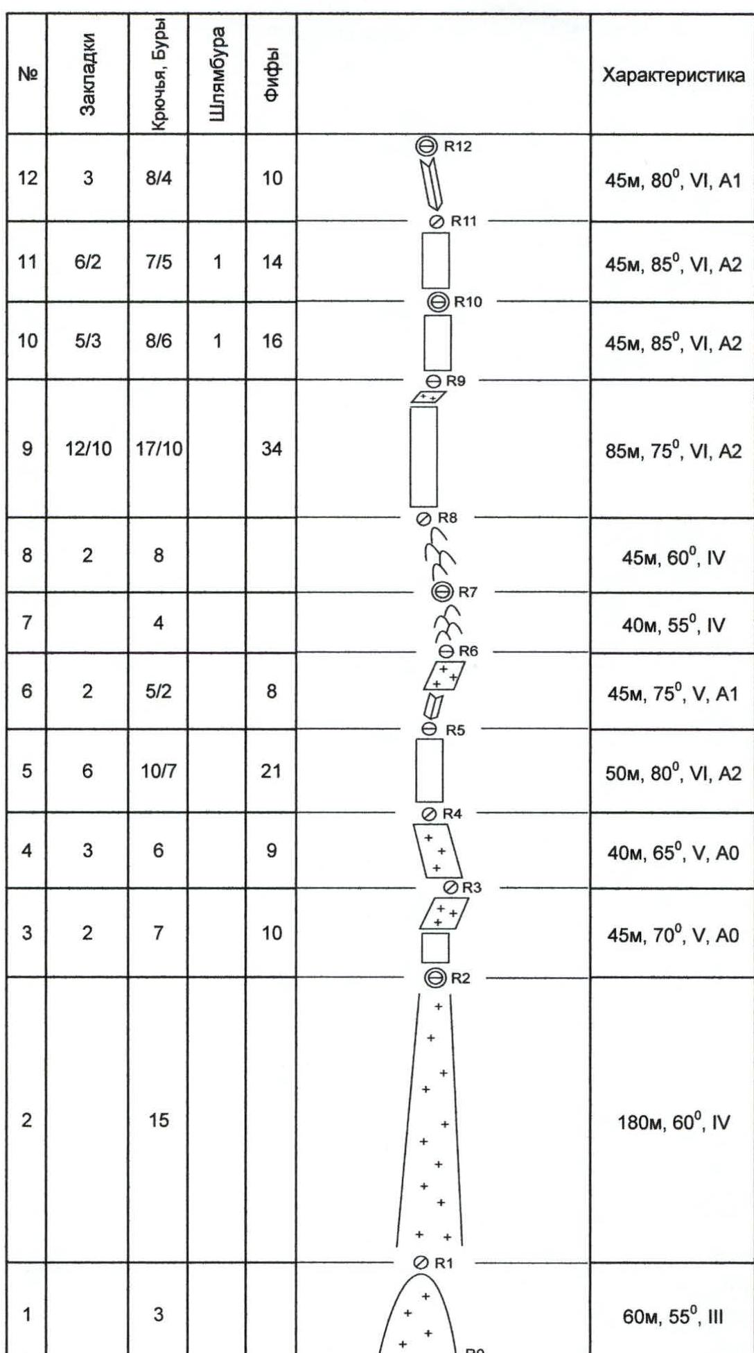
| № | 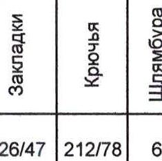 |  |  | Фифы | Характеристика |
|---|---|---|---|---|---|
| Total | 126/47 | 212/78 | 6 | 274 | 200 m, II |
| 23 | 8 | 15/6 | 17 | 70 m, 70°, 6, A1 | |
| 22 | 11/6 | 8/5 | 14 | 40 m, 85°, 6, A2 | |
| 21 | 10/2 | 8 | 9 | 45 m, 65°, 6, A1 | |
| 20 | 8/4 | 10/5 | 16 | 45 m, 70°, 6, A2 | |
| 19 | 4 | 7 | 10 | 50 m, 70°, 5, A1 | |
| 18 | 3 | 6/2 | 11 | 45 m, 70°, 5, A1 | |
| 17 | 6/2 | 8/3 | 17 | 40 m, 90°, 6, A2 | |
| 16 | 10/7 | 12/4 | 2 | 15 | 50 m, 80°, 6, A2 |
| 15 | 4 | 10/3 | 10 | 40 m, 75°, 5, A1 | |
| 14 | 14/8 | 20/12 | 2 | 21 | 65 m, 85°, 6, A2 |
| 13 | 7/3 | 10/4 | 12 | 45 m, 85°, 6, A2 | |
| 12 | 3 | 8/4 | 10 | 45 m, 80°, 6, A1 | |
| 11 | 6/2 | 7/5 | 1 | 14 | 45 m, 85°, 6, A2 |
| 10 | 5/3 | 8/6 | 1 | 16 | 45 m, 85°, 6, A2 |
| 9 | 12/10 | 17/10 | 34 | 85 m, 75°, 6, A2 | |
| 8 | 2 | 8 | 45 m, 60°, 4 | ||
| 7 | 4 | 40 m, 55°, 4 | |||
| 6 | 2 | 5/2 | 8 | 45 m, 75°, 5, A1 | |
| 5 | 6 | 10/7 | 21 | 50 m, 80°, 6, A2 | |
| 4 | 3 | 6 | 9 | 40 m, 65°, 5, A0 | |
| 3 | 2 | 7 | 10 | 45 m, 70°, 5, A0 | |
| 2 | 15 | 180 m, 60°, 4 | |||
| 1 | 3 | 60 m, 55°, 3 |
Approach from Lecho hut to the base of the wall takes about 3 hours. The lower part of the route coincides with route № Siesta. In the middle section, the route goes to the right of № Siesta and follows a distinct gray sickle-shaped feature. The upper 5 pitches also coincide with route № Siesta. All bivouacs on the wall were set up on platforms. Descent: — initially along the ascent route, — then following the water fall line to the ice couloir, — further down the ice. All rappel stations were equipped with loops on the descent.
In summer, it is possible to climb the entire route using free climbing, with an approximate grade of 7a–7b, M7. The route's complexity is comparable to neighboring routes № Siesta and Manitua, but it seems that in the middle section, the route is more challenging than № Siesta, as it traverses a steeper wall section with less pronounced relief. Meanwhile, № Siesta follows a distinct internal corner and has ledges for bivouacs.
Route Description by Sections
Section 1. From the bergschrund up a snow slope for 60 m.
Section 2. Up an ice couloir for 180 m. First bivouac at the end of the couloir.
Section 3. A wall 30 m, followed by an inclined snow-ice ledge 20 m.
Section 4. Up and left on an iced-over slab for 40 m.
Section 5. A vertical wall transitioning into an internal corner. Many loose rocks, difficult protection!
Section 6. A vertical corner gradually easing into an inclined snow ledge.
Section 7. Moderately difficult broken rocks for 40 m. Station under a vertical monolithic wall. Second bivouac here.
Section 8. Broken rocks, steepness gradually increases. Move left and up for 85 m.
Section 9. A vertical wall with varied relief for 25 m. Many loose rocks!
An inclined chimney (20 m) leads to a small ledge. Then route № Siesta goes left and up a distinct internal corner. Our direction is slightly right and up towards a small overhang, behind which the sickle-shaped feature begins.
Section 10. A vertical wall gradually transitioning into a slight overhang.
Many loose blocks!
A bolt at the end of the pitch.
Third bivouac.
Section 11. A vertical wall with a small overhanging cornice for 45 m. Entrance to the sickle. Section 12. Following the sickle, an internal corner, left and up for 45 m. Station in the corner. Fourth and fifth bivouacs. Section 13. Continuing the sickle for 45 m. Station in a flake. Section 14. The sickle changes from an internal corner to a system of diagonal cracks for 65 m. Difficult protection. 50 m into the pitch, a bolt is placed, followed by another 15 m later. Section 15. A pendulum swing left for 8 m into a neighboring internal corner (possible to free climb). Corner with ice, ending with a traverse left onto a small ledge. Section 16. A vertical wall for 20 m. An internal corner for 30 m, ending in a cornice. Under the cornice, the remaining bivouacs were set up. Section 17. The cornice is bypassed on the left. Then a vertical wall of loose rocks for 40 m.
Section 18. Mixed terrain for 90 m, exit onto a small ledge type "shoulder". Stationary loop on the shoulder. Junction with route № Siesta.
Section 19. A wall for 30 m. An inclined internal corner left and up for 15 m.
Section 20. Continuing the internal corner for 45 m.
Section 21. A wall for 40 m. Poor relief, difficult protection. Entrance to an internal corner.
Section 22. Mixed terrain up the internal corner for 70 m to the ridge.
Section 23. Along the ridge to the summit for 200 m.
No control tour or note found on the summit.
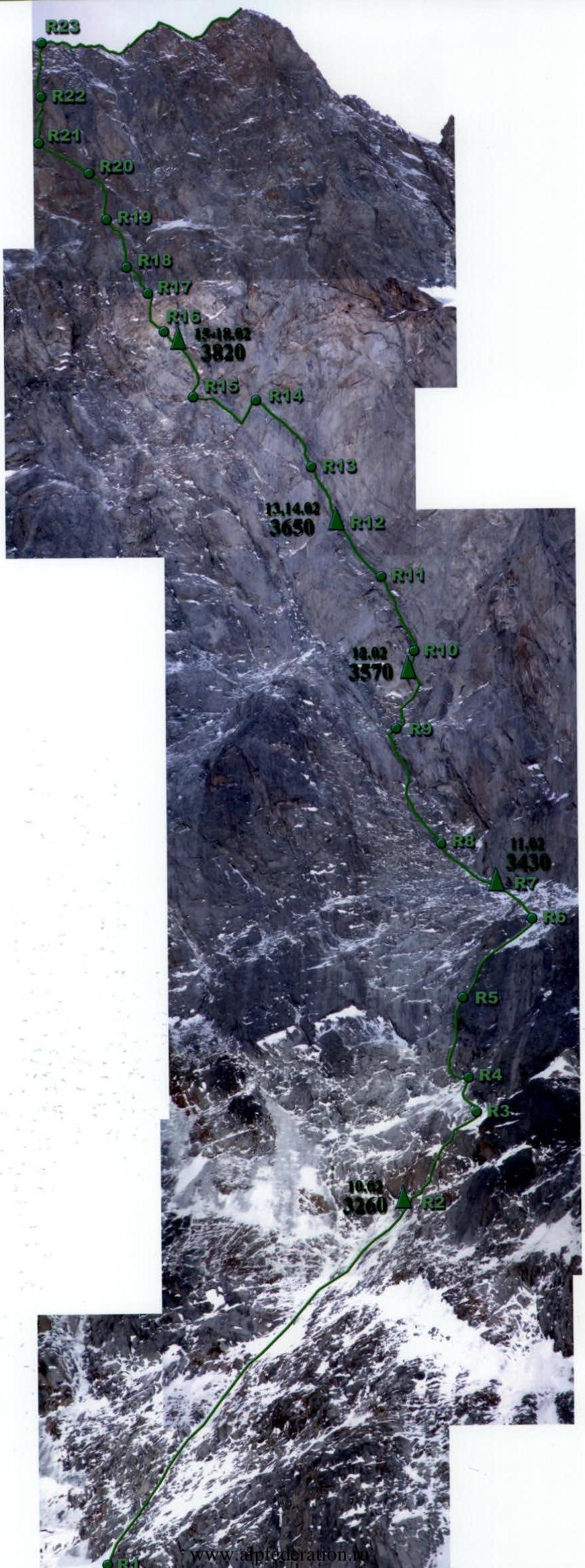
Ascent Log (2006)
- February 11: 3430 m
- February 13–14: 3650 m
- February 14: 3570 m
- February 15–18: 3820 m
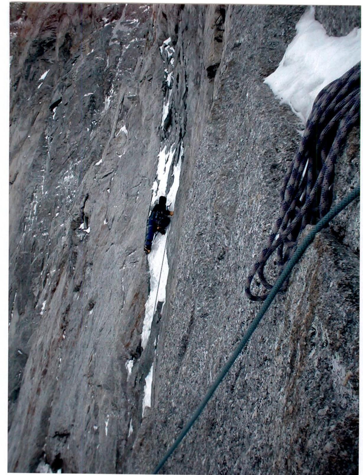 Section 15. A. Litvinov leads.
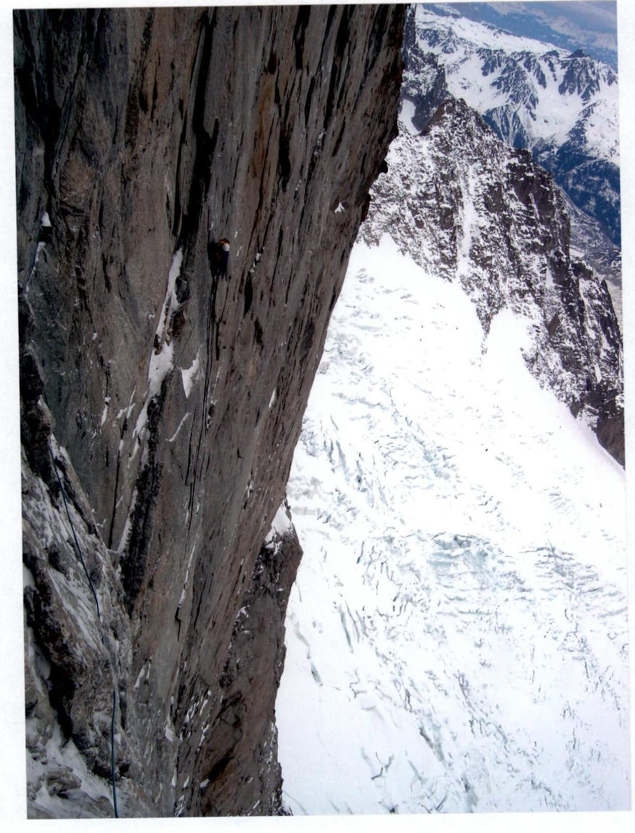 Sections 14–15. View from above.
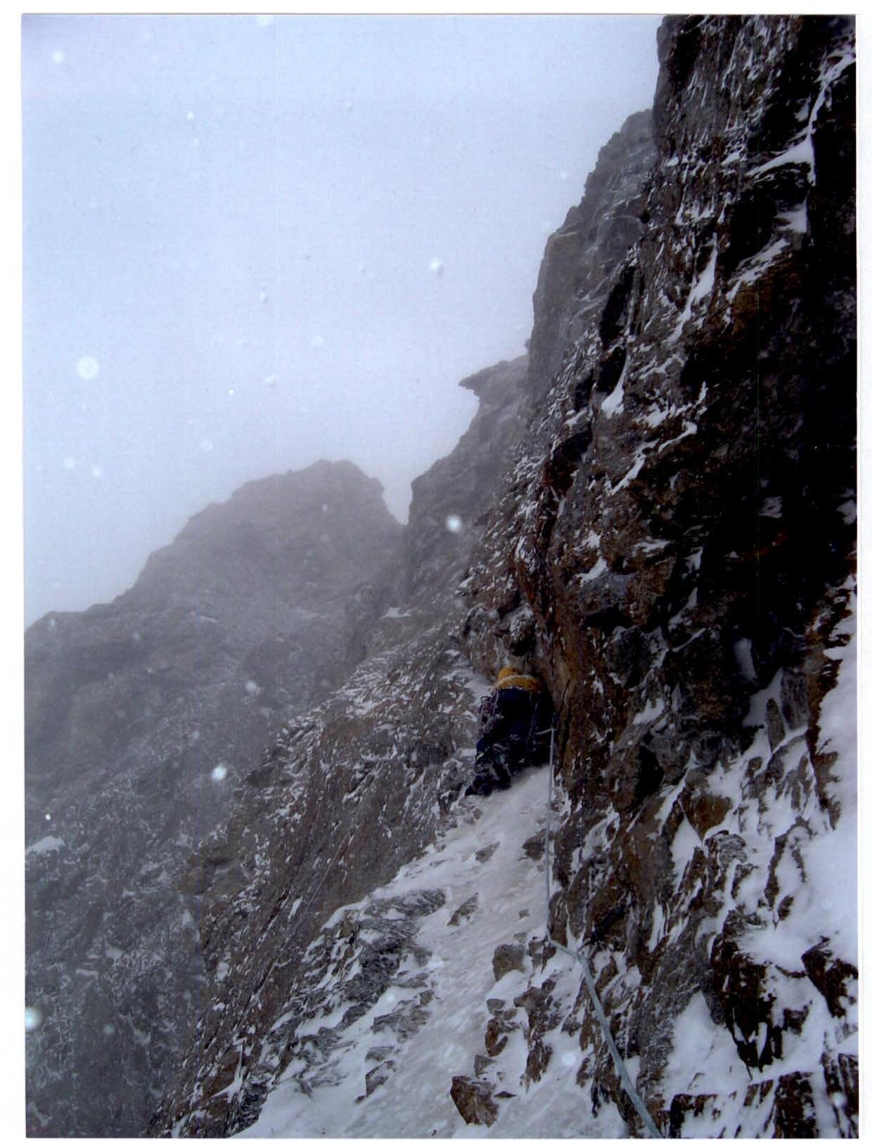 Section 21. O. Khvostenko leads.
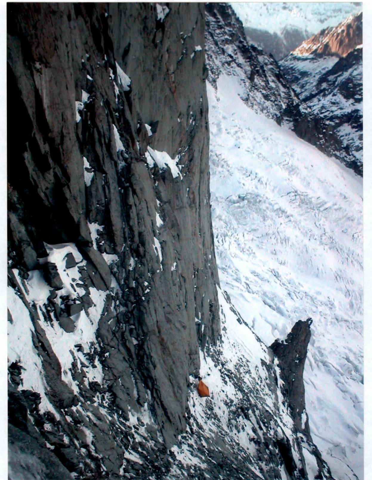 View from station R9 down to camp 2 tent.
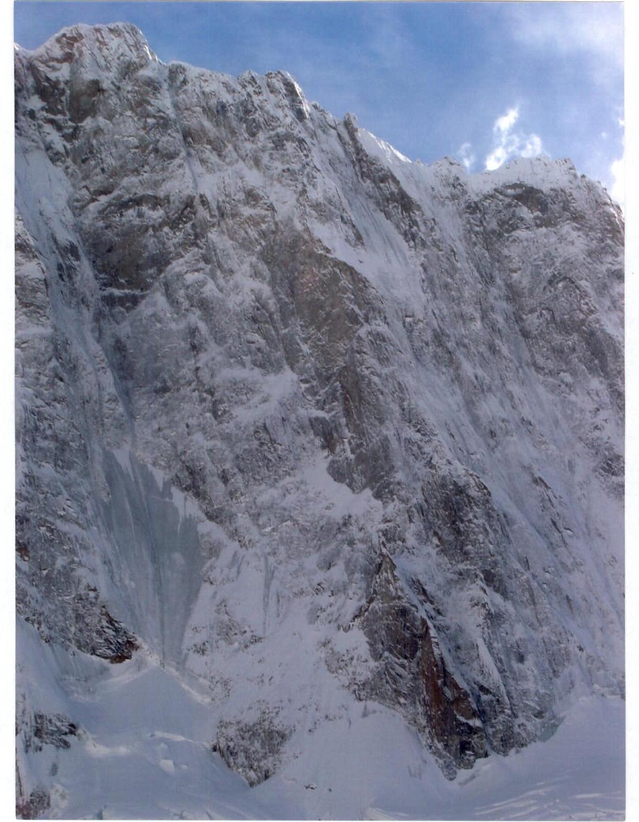 View of the north face of Grand Jorasses after snowfall.


