Krasnodar Region Alpinism Federation Russian Alpinism Championship
High-Altitude Technical Class
Report
ON ASCENDING GRANDES JORASSES, P. WALKER (4208 m) VIA THE LEFT SIDE OF THE LARGE INTERNAL CORNER OF THE EASTERN WALL, ACCOMPLISHED BY THE TEAM OF KRAI PUBLIC ORGANIZATION "Krasnodar Region Alpinism Federation".
Presumably 6B category of difficulty. FIRST ASCENT
Gorodishchenskiy R. R. Foygel M. R.
2016
Table of Contents
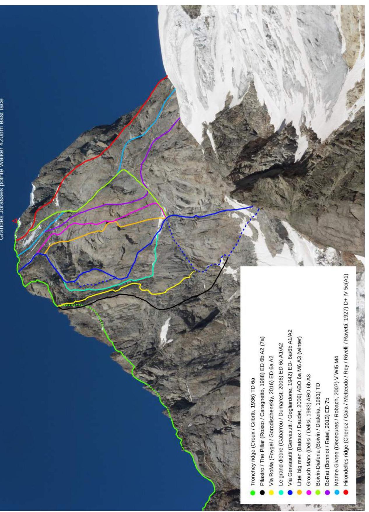
Table of Contents — 2 Route Passport — 3 General Photo of the Summit — 4 Drawn Route Profile — 5 Photopanorama of the Massif from the South — 6 Photopanorama of the Massif from the North — 7 Photopanorama of the Massif from the East (Eastern Wall) — 8 Ascent Schedule — 9 Tactical Actions of the Team — 10 Route Diagram in UIAA Symbols — 12 Technical Photograph of the Route — 15 Technical Photograph of the Key Part of the Route — 16 Route Description by Sections — 17 Photographs of Route Sections — 20
Route Passport
- Region: Alps, Western Alps, Mont Blanc region
- Summit: Grandes Jorasses, p. Walker (4208 m) Route: via the left side of the large internal corner of the eastern wall Route Name: "Via RoMa"
- Category of difficulty: proposed — 6B, first ascent
- Route character: rock, snow, and ice on the approach and descent
- Total route length: 1345 m Length of the wall section: 490 m Length of sections: 5th category of difficulty (F5a) — 120 m 6th category of difficulty (F5b–6A) — 185 m, including 55 m of artificial technical climbing (ITC) Average steepness: main part of the route — 74°, total route — 60°
- No count of used pitons was made. No drill holes were used. 1 friend and 3 rock pitons were found on the route and left in place.
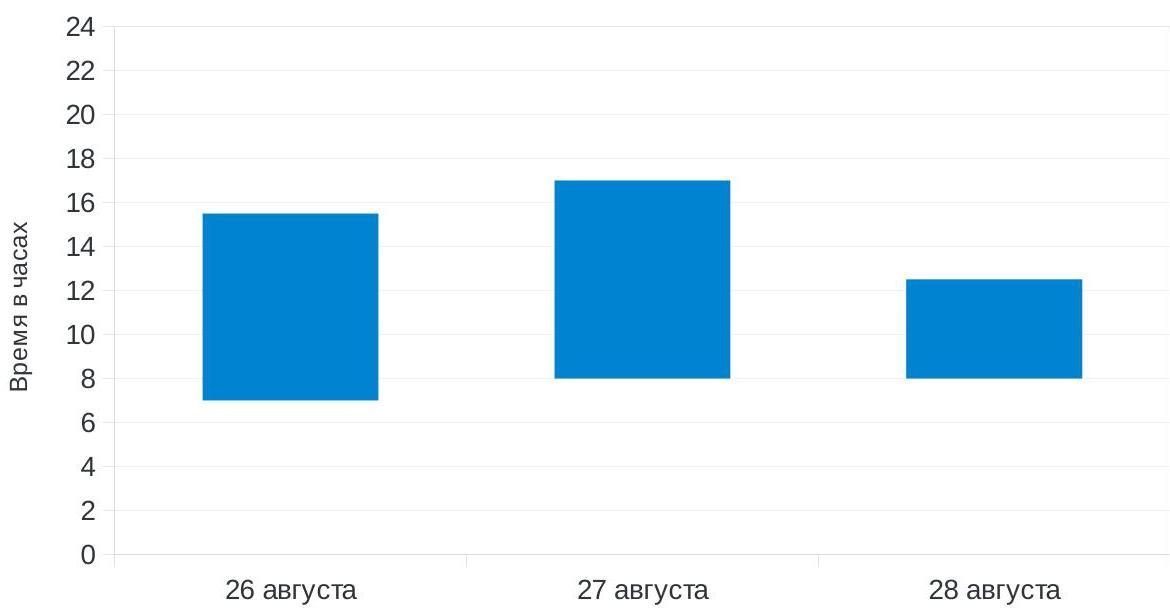
- Team's total climbing hours: 23 hours / 2.5 days
- Participants: Foygel M. R. (Candidate for Master of Sports); Gorodishchenskiy R. R. (Candidate for Master of Sports) Coach: Prilepa E. V.
- Approach start date: August 25, 2016 Route start date: 7:00, August 26, 2016 Summit arrival time: 12:30, August 28, 2016 Return date: August 28, 2016
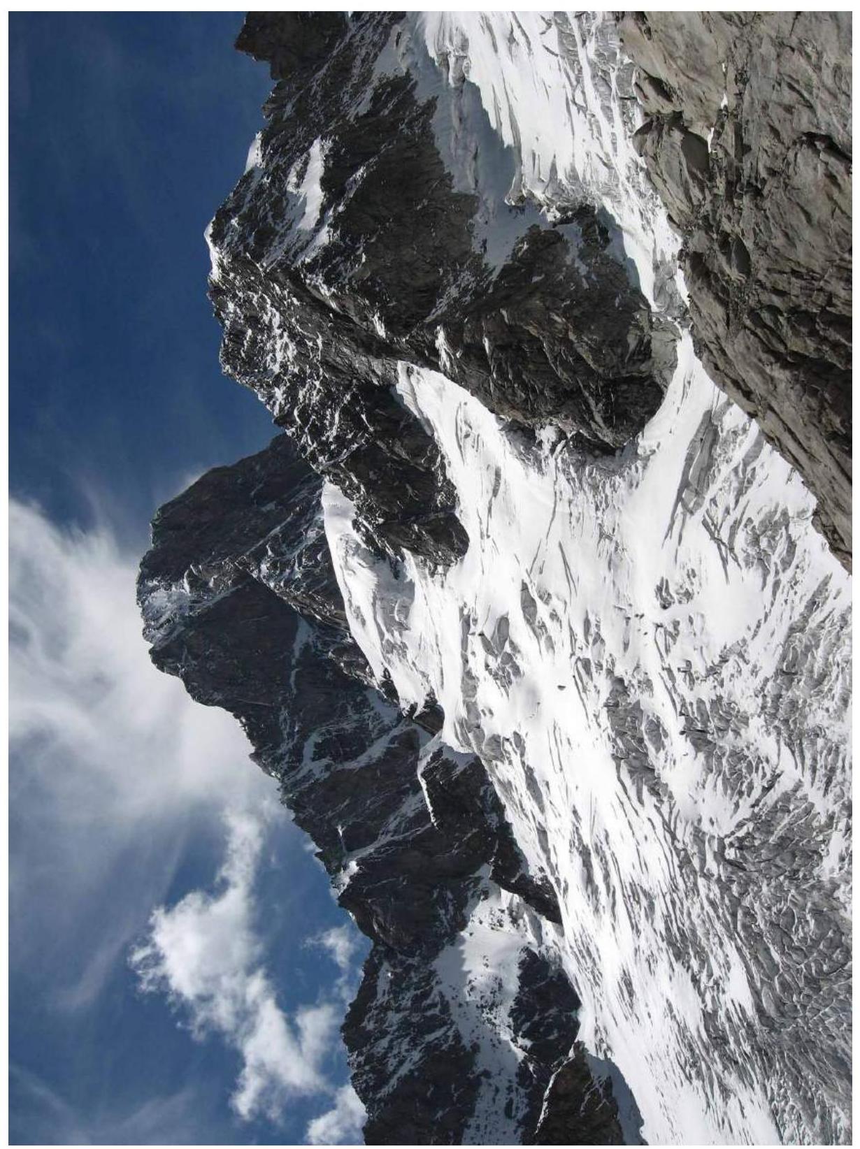
General Photo of the Summit
Drawn Route Profile

Photopanorama of the Massif from the South

Photopanorama of the Massif from the North

Photopanorama of the Massif from the East (Eastern Wall)
Ascent Schedule
Tactical Actions of the Team
The route traverses the left side of the large internal corner of the eastern wall of Grandes Jorasses, p. Walker (4208 m). This is one of the most renowned peaks in the Alps, featuring numerous challenging routes.
While exploring and familiarizing ourselves with the new area by undertaking relatively straightforward technical ascents in the Val Ferret valley, we turned our attention to the highest peak, which terminates in a vertical eastern wall. After thoroughly studying the materials related to the routes on this peak, we selected a free and logical line for the first ascent between the routes:
- The Pillar (Rosso/Caragnetto, 1988)
- Le grand diedre (Gabarrou/Dumarest, 2006)
Based on the photographs we studied, we anticipated a rich terrain, and accordingly, we selected our gear.
(Photo)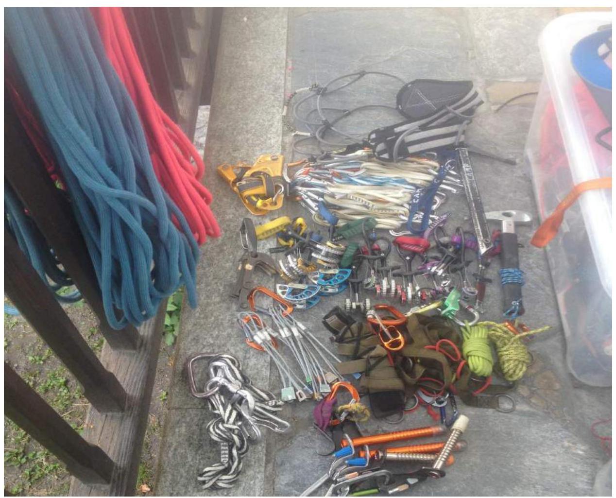
The approach to the route begins from the road in the village of Lavanchey. The trail proceeds along the orographic left moraine, then ascends via a series of rocky outcrops to a flattening, from where the path continues along the Freboudze Glacier — a rather steep and broken glacier comprising three steps of 45–50°, leading to the Hirondelles pass. The approach took 6 hours.
Initially, we planned to camp for the first night on the pass, then overcome the wall in one day and camp under the upper bastion of the Tronchey ridge — this is roughly 2/3 of the route. On the third day, we intended to traverse the bastion, reach the summit, and descend. We also had a spare day planned in case of bad weather or unforeseen circumstances. However, due to the complexity of the transition from the Hirondelles pass to the eastern wall being greater than anticipated, we had to adjust our plans.
The movement scheme for the pair was as follows: the leader moved with a small backpack on a double rope. The rope length was 60 m. One rope was used for belaying, and the other for fixed ropes. On key sections, the leader's backpack was left at the anchors, and then retrieved by the second climber. The entire route was led alternately.
The wall is composed of granite. The base of the wall is partially degraded. The main part is entirely monolithic, except for a few sections. All stations on the route were made from our own anchors and were backed up with a loop or cordelette. The weather was clear but windy. We did not carry water, as it was possible to find snow or ice on the ledges.
The wall section of the route was commenced at 10:00. The route is sunlit from 7:00 to 11:00. On this day, we completed sections R0–R7. On section R7, a convenient platform for a tent was established. We named it "Russian bivouac." One key rope was processed.
On the following day, we tackled all the most technically challenging sections of the route (R7–R13). The pair began working at 8:00. Particular difficulties were encountered on:
- section R12–R13
- the overhang on section R9–R10
- several diagonal, overhanging ropes that made it difficult for the second climber to move with two backpacks.
At 17:00, upon reaching a ledge at the base of the upper bastion of the Tronchey ridge (R14), we decided to set up camp.
At 20: R10–R11 40 m 75° 6 (5c)
Further, the route proceeds up the ridge, becoming increasingly steep and technically complex.
R10–R11 40 m 75° 6 (5c)
Next, we ascend via the groove to the next belt of overhanging rocks. The station is situated on a flattening, approximately 5 m below the chimney.
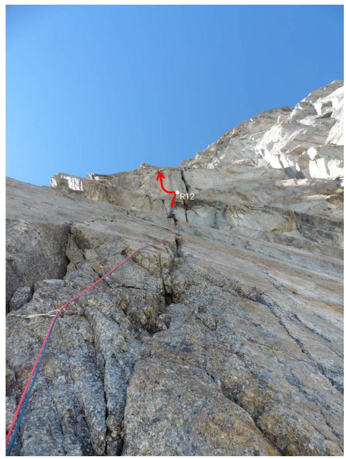
R11–R12 30 m 75–95° A2 5 (5a)
From the station, ascend via a thin crack upwards, then traverse left into the neighboring crack and approach under the overhanging internal corner (5 m 5 (5a)). Ascend via the corner (ITC). At the top of the corner, there are wedged "live" stones. Above, the corner transitions into a wide crack-gutter, and via this (ITC), we reach a flat slab under the base of a large overhanging chimney. Here is the station.
R12–R13 45 m 85–105° A2 4
From the station, traverse left to the second crack (counting from the chimney) (5 m 4). Ascend via this overhanging crack to under the cornice (15 m 95° A2). The cornice is traversed head-on via the crack (5 m 105°). Behind the cornice is a vertical wall with a thin crack; ascend via this to the ledge (10 m A2). Practically the entire assortment of protection — from pitons to medium-sized friends — is effective here. From the ledge, ascend via simple rocks to the main ridge (10 m 4). The station is just below the ridge.
R13–R14 100 m 45–60°, 3–4
Next, ascend to the ridge and proceed along the simple rocks of the ridge to under its steep rise (80-meter bastion). Under the base of the bastion lies a large debris ledge. The station is located at the extreme right part of this ledge on an outcrop.
Here is a convenient spot for a bivouac, with snow available for melting water. This is the last location before the summit where a comfortable bivouac with a tent can be set up.
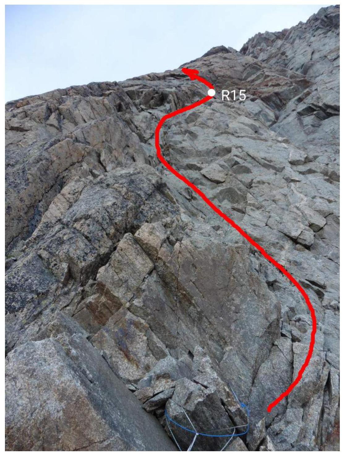
R14–R15 45 m 70° 5 (5a)
From the ledge, make a small traverse to a wide internal corner. Ascend via the corner to its end. Then, ascend rightwards to a ledge with large "live" blocks under the overhang. Here is the station.
The climbing is not particularly difficult but is quite tense due to the "live" stones and unreliable terrain.
R15–R16 35 m 85–95° 5+ (5a)
From the station, ascend left-upwards behind the bend to a monolithic wall with rich terrain and good cracks for protection. Ascend via the wall to a small cornice, which is traversed from right to left (5 m 95°). Then, continue upwards-leftwards to the main ridge. The station is just below the ridge.
R16–R17 25 m 45° 3
Next, proceed along the simple rocks on the right side of the ridge, bypassing its steep section, to a small saddle on the ridge. Here is the station.
R17–R18 300 m 35–65° 2–3
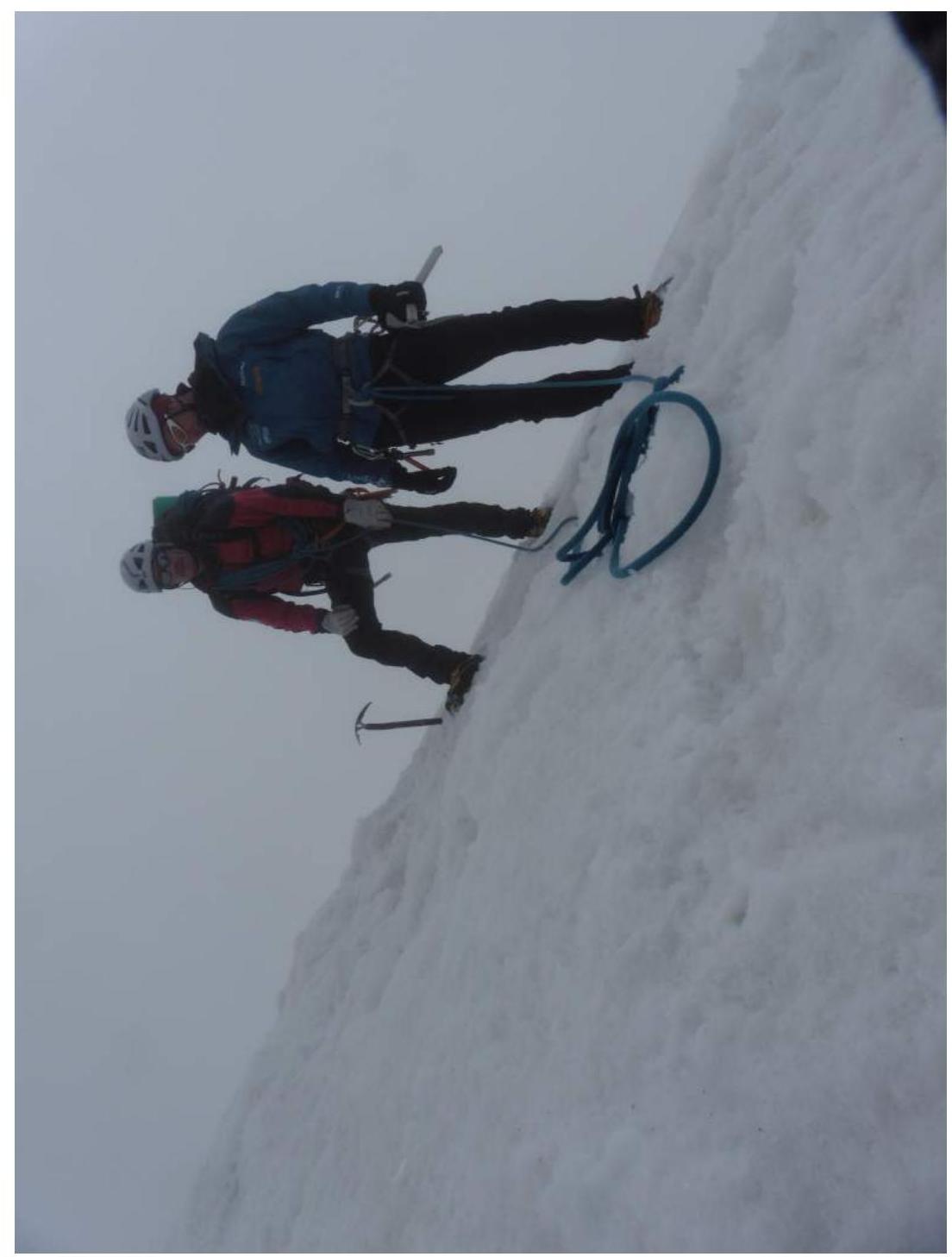
From the saddle, ascend along the not-too-difficult but heavily degraded rocky ridge to the pre-summit snowy ridge.
R18–R19 50 m 25°
Along the left side of the gentle snowy ridge (cornices), ascend to the summit.
Photographs of Route Sections

Section R1–R2

Section R3–R4. Wet groove — A1

Section R5–R6

Section R6–R7

Sections R8–R10
- The start of section R8–R9 is clearly visible
- Cornice on section R9–R10
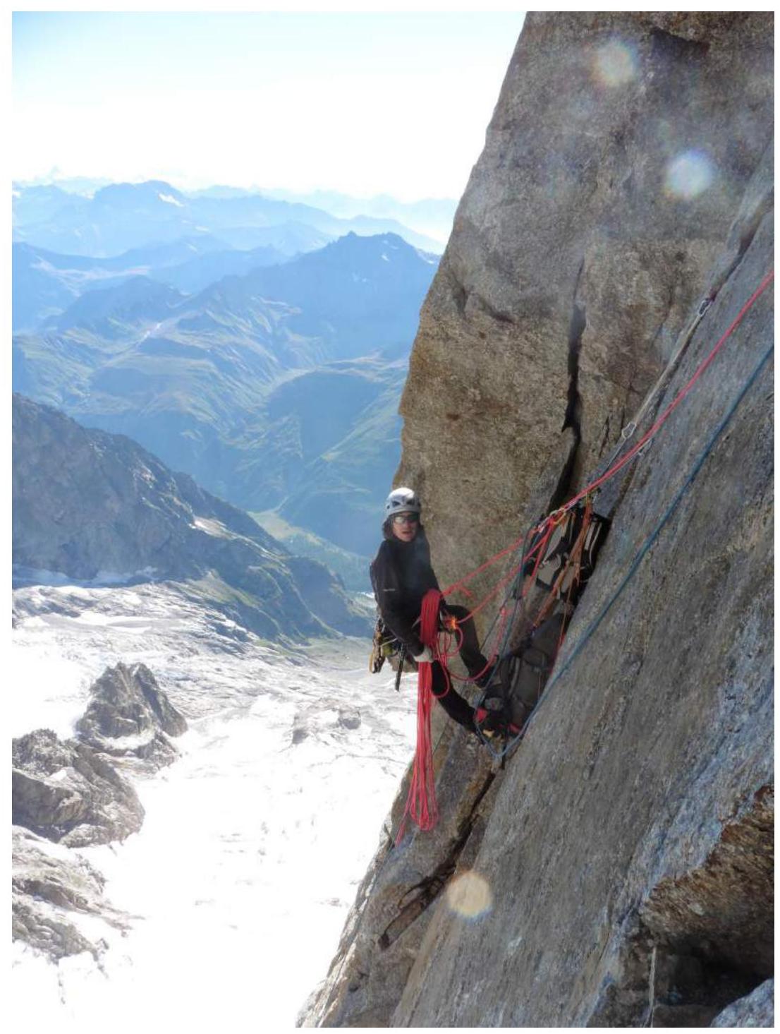
Station R9

Upper part of section R9–R10
Section R10–R11
- Upper part of the wall
- Sections R12, R13

Section R11–R12

Section R11–R12
Upper bastion of the Tronchey ridge
Summit


