
Ascent Log
- Mountain range: Karakoram Gorge: Nangma. Peak name: Shingu Charpa (This peak is not listed in the 2001 classification table).
- Route name: "Never More" via the Central Eastern wall
- Estimated difficulty category: 6B first ascent
- Route type: combined
- Route characteristics: Height difference: 1600 m Route length: 2360 m Section lengths: Category V difficulty: 307 m Category VI difficulty: 1222 m Average slope: main part of the route: 78° total route: 67°
- Pitons used on the route: Stationary bolt pitons: 0 pcs Removable bolt pitons: 4 pcs at the second bivouac total: 4 pcs Total artificial protection points (APs) used: 546 pcs Pitons left on the route: rock: 2 pcs bolts: 0 pcs ice: 0 pcs snow: 0 pcs
- Team's travel time on the route: 165.5 hours (21 days)
- Team leader: Devi Mikhail Marenglenovich, sports qualification: ZMS, MSMK Team members: Klenov Alexander Valerievich, ZMS, MSMK Shabunin Alexander Anatolievich, MS
- Coach: Klenov Alexander Valerievich, sports qualification: ZMS, MSMK
- Route start: 10:00, August 4, 2007 Summit: 16:00, August 24, 2007 Return to Base Camp: 18:00, August 27, 2007
General Photo of the Summit
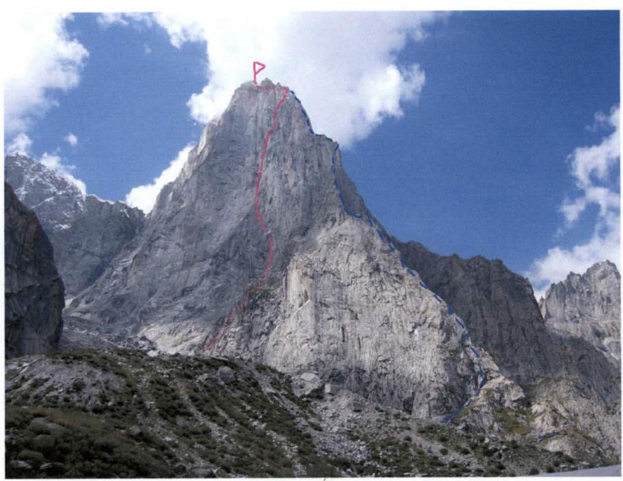
Red — team's route Blue — Chaplynsky's route (2006). Photo taken on August 29, 2007. Shot location — base camp.
Description of the Climbing Area
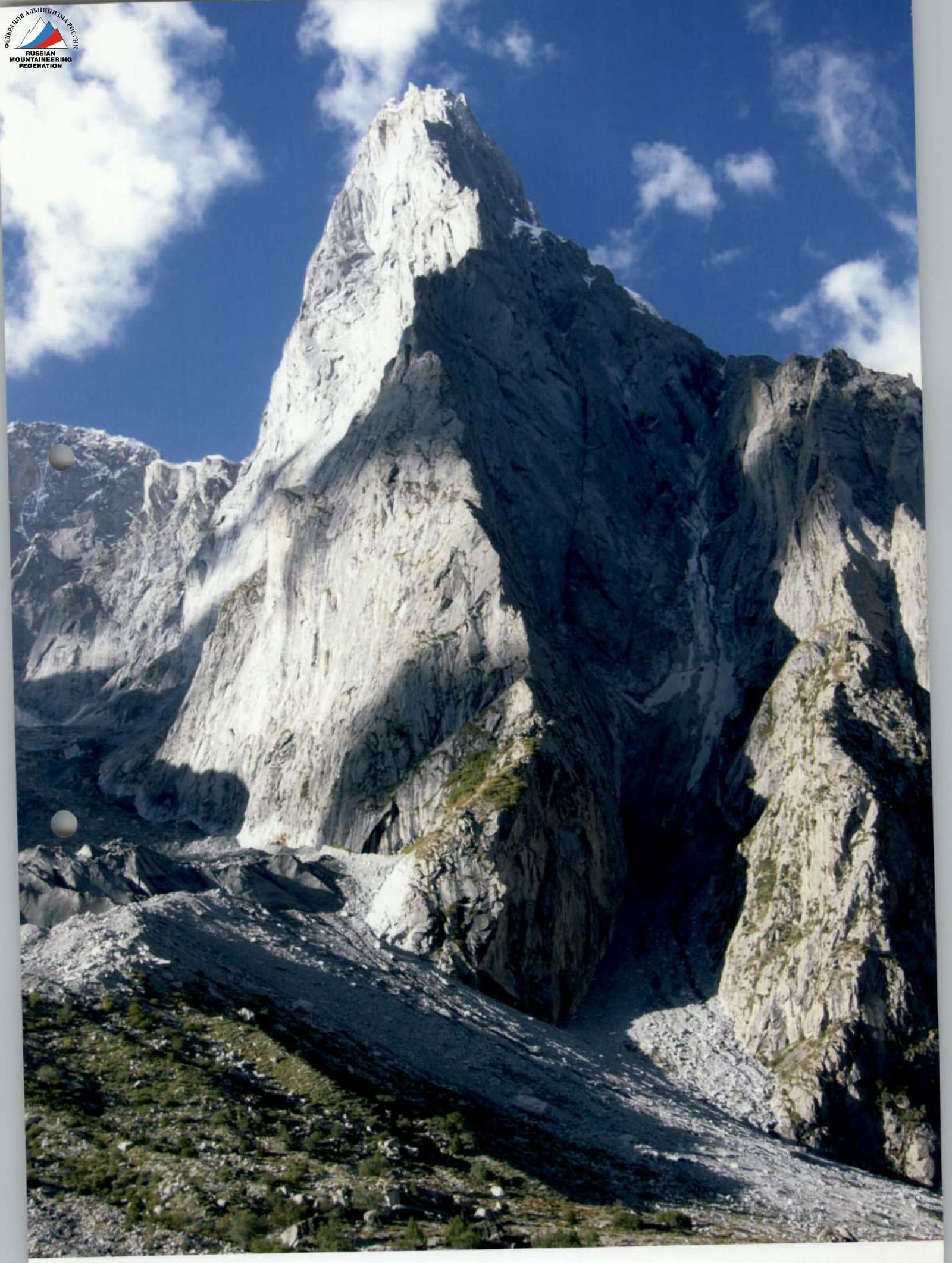
Shingu Charpa peak (5800 m) is located in the picturesque and relatively infrequently visited Nangma valley. The valley walls contain seemingly endless rock potential for climbing in all alpinist styles. Interest in this area emerged about 10 years ago and has been growing every year. The most famous peaks are Amin Brakk and Shingu Charpa, but there are also many rock peaks with walls 10–20 pitches long that attract rock climbers and alpinists from around the world each year.
The most favorable season for climbing is June–August.
Expeditions typically start from Skardu:
- By jeep to the village of Kande (4–5 hours)
- Then on foot along the Nangma gorge, with one overnight stay on the way.
The transitions are short, and in principle, with a light load, one can reach the base camp (BC) in one day (and return the same way).
The BC is located in a beautiful green oasis at an altitude of 3900 m. Nearby, there's a grove of birches and willows, and a spring. The approach to the start of the route from the BC takes 2–3 hours, depending on acclimatization and the state of the glacier.
For a limited budget, alternatives are available:
- Public transport (bus) to the relatively large village of Kanni (Khaplu) with all kinds of services and accommodations.
- From Kanni to Kande, a public jeep for locals runs daily, which can be taken for a small fee.
History of the Peak's Conquest
According to a widely circulated version, the first ascent was made in 2000 by a Korean team consisting of Shin Dong Chul, Byung Young Ho, and Hwang Young Chul. The Koreans planned to fix ropes on the North ridge and ascend to the summit but soon realized the scale of the endeavor and switched to a rocky, snowy-icy couloir to the right. After fixing 700 m of rope up to an altitude of 4800 m, they were delayed for seven days in the upper part of the western wall, then reached the summit. However, the fact of their ascent is disputed by independent observers in the valley (one of the most well-known and respected witnesses is Wojciech Kurtyka).
In any case, having reached the summit, we can confidently say that the upper loops of the Americans and Ukrainians are at a significant distance (at least 6–7 pitches) from the summit, and we did not find other signs of people being in the area. We tend to believe that we made the first ascent of this peak.
More history: in 2001, Todd Offenbacher, Nils Davis, Brian McCray, and Bryton Waren attempted to climb the North ridge. Working in a capsule style, they completed over 20 pitches in five days, after which they abandoned their goal due to an injury to one of the participants.
The "Montagne" journal included Shingu Charpa in the list of the most interesting unclimbed routes in the world. The world-renowned company "Polartec" awarded a "Polartec Challenge" grant in 2006 for an expedition to climb the ridge of Shingu Charpa. Americans Kelly Cordes and Josh Wharton took on this project, but Ukrainians beat them and were the first to tackle the ridge of Shingu Charpa. In the summer of 2006, Igor Chaplynsky, Andrey Rodiontsev, and Orest Verbitsky reported completing the north ridge in 5 days in alpine style; the route was nominated for the "Golden Ice Axe" award.
Unfortunately, their summit was also disputed by observers and later by the team members themselves. The Americans who followed them also failed to reach the summit and admitted it honestly. The lack of ice equipment among all participants prevented these teams from achieving their goal.
In different years, strong alpinists from Canada, Slovenia, Poland, Russia, and Austria attempted to conquer the peak from various sides.
Our team is proud to have not only reached the summit but also climbed a new, currently the most difficult route on the eastern wall of this challenging peak.
Map of the Nangma area, Pakistan.


- C: CHANGI TOWER about 5300 m
- M: MARPO BRAKK about 5300 m
- B: KORADA PEAK
- S: ZING (FATHER) AND SON
- J: JONONO TOWERS
- M: MARTHAK PEAK about 5600 m
- GT: GREAT TOWER: SHINGU CHARPA about 5800 m
- GRT HEEN TOWER about 4500 m
- NN NO NAME WALL about 4500 m
- Z: ZANG BRAKK 4800 m
- L: LOBSANG PEAK about 5700 m
- A: AMIN BRAKK about 5800 m
- N: NAWAS BRAKK about 5700 m
- K: KARKOM BRAKK about 4900 m
- DENBOR BRAKK about 4800 m
Schematic from the report of the Slovenian reconnaissance expedition in 2004. http://www.gore-ljudje.net/objave/brankoi/nangma/nangma-skica.jpg ↗
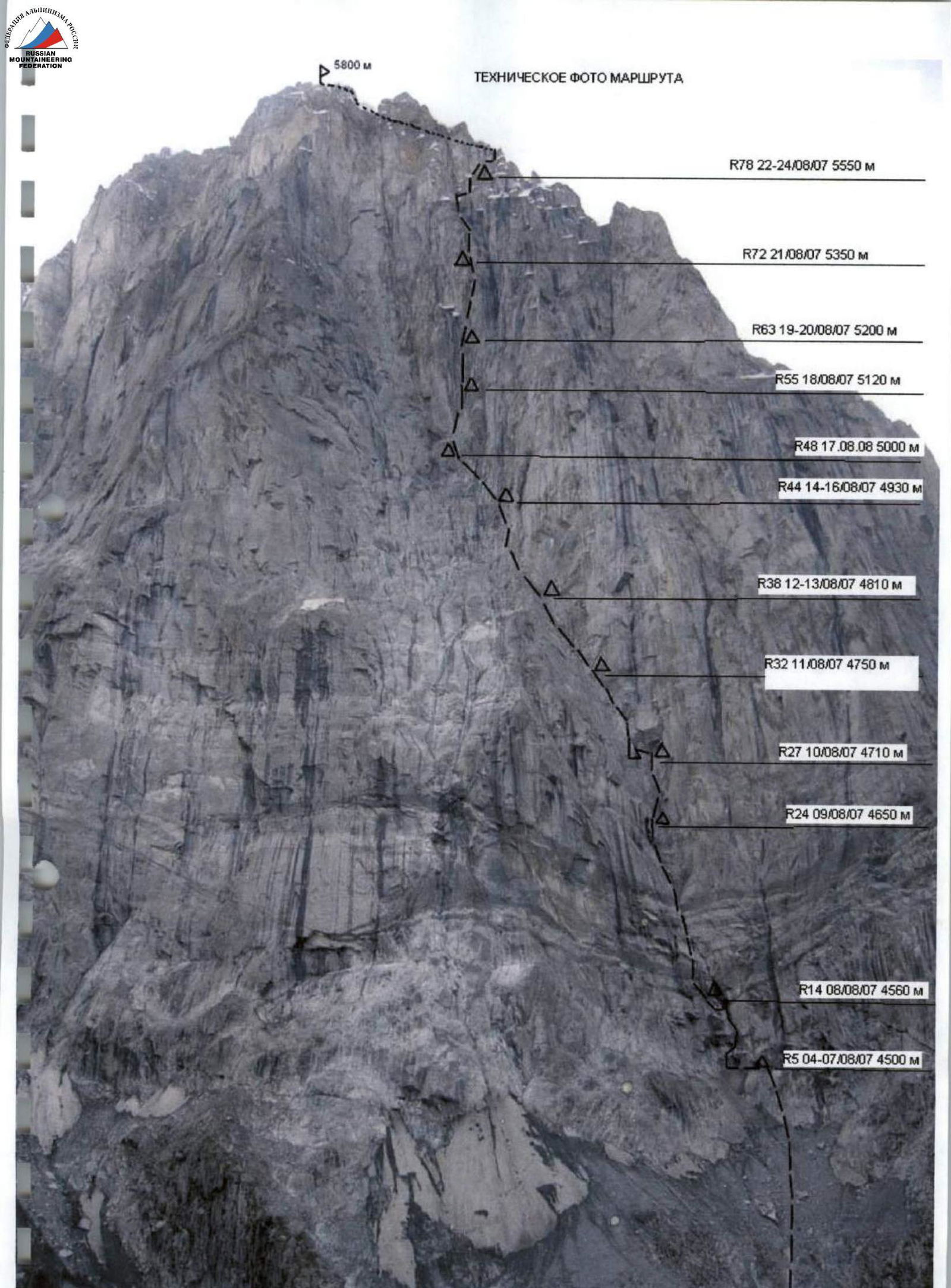
Ascent Graph

Days of ascent Weather conditions: yellow — no precipitation, drops — rain, blue — wet snow, white — snow.
Technical and Tactical Actions of the Team
According to the plan, the team spent a week after arriving at the BC on acclimatization and thorough reconnaissance of the approaches to the planned route of Shingu Charpa. During this time, we observed the state of the wall and the schedule of rockfalls in the area, brought the main part of the equipment under the wall, and made a warm-up ascent on the wall of a lower (4500 m) rock peak opposite the eastern slopes of Shingu Charpa. The warm-up ascent allowed us to feel many future complexities of the ascent in this area and take quality photos of our main expedition goal.
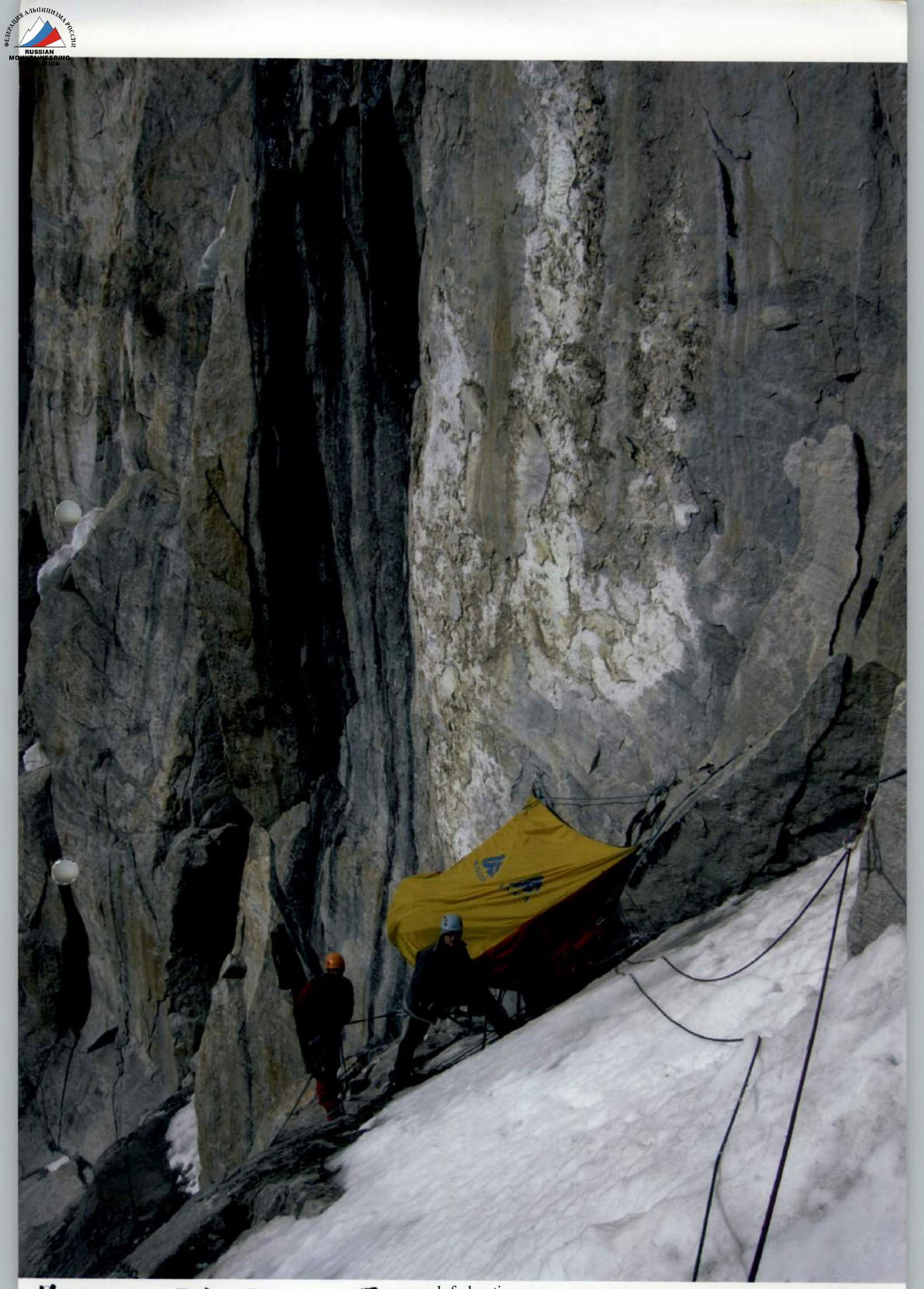
The route start was on August 4, 2007. Quickly passing the not very complex initial part of the route, we set up a platform under the main part of the wall at a pre-planned location, well-protected from falling rocks by large cornices. Due to significant rockfall caused by sharp temperature fluctuations on the eastern wall and bad weather in the area, the choice of bivouac location was one of the most important aspects of the ascent. We reinforced the platform only on significantly overhanging areas or under cornices, which helped avoid accidents, although it slightly slowed down the team's progress. Daily movement of the platform was necessary due to the lack of nearby bivouac sites meeting all our requirements. Therefore, sometimes we moved only one pitch, and sometimes we processed three sections to be able to reach a safer spot on the wall the next day.
Major rockfalls on the eastern wall occur after sunset from 20:00 to 11:00 local time when water on the wall freezes in cracks, sometimes detaching giant rock blocks. There's also a pronounced morning rockfall starting when the wall is illuminated by the sun (i.e., around 6:00), but morning rockfalls are less intense and mainly consist of falling ice.
Due to the abundance of falling rocks and high abrasiveness of the rock, movement on fixed ropes was carried out only on double ropes.
The team had a sufficient supply of gas and food for 20 days of climbing + reserve. Initially, we had 50 liters of water, but the prolonged bad weather allowed us to abandon carrying water reserves. However, in dry weather, the wall has very limited spots for replenishing water and snow, which should be considered by future climbers.
Considering the experience of previous expeditions that did not reach the summit, we brought crampons for all team members and necessary ice equipment for the snowy-icy section before the summit.
The first climber moved mainly using free climbing with rare use of APs in places where rock destruction or dirt and calcite deposits in cracks made it impossible to organize quality protection using free climbing. The lead changed daily. The first climber went with two dynamic ropes. The second climber ascended on the fixed ropes with a backpack. Since pulling up the haul line on this wall was very dangerous due to the risk of dropping rocks, the third climber had to pass each section twice (once with the haul line, and again with the platform).
Interaction with the BC and the English part of the expedition was carried out using radio communication according to a pre-established schedule. The group's progress was monitored from the BC using binoculars. The BC, in turn, had a connection with the nearest village, which had telephone communication. A pre-paid deposit for a rescue helicopter allowed us to expect its arrival within a day of an incident in case of an emergency.
The complex of the above-mentioned tactical actions enabled the team to achieve what many well-known alpinists from different countries were unable to accomplish since 2000, and on August 24, 2007, we made the first ascent to the summit of Shingu Charpa via a new, currently the most difficult route on the eastern wall.
Route Diagram in UIAA Symbols
M 1:2000 (Sections longer than 100 m and shorter than 10 m are not to scale)
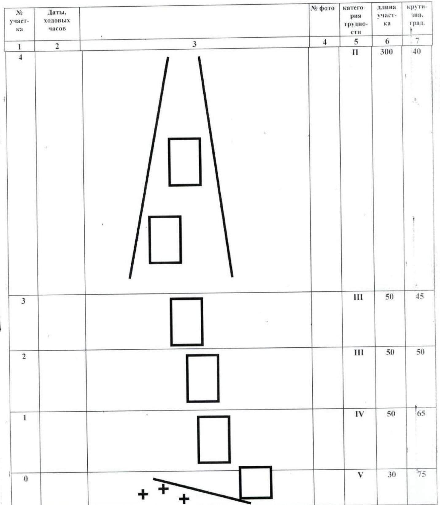
| № | Dates, times | Description | Photo | Difficulty | Length, m | Slope, ° |
|---|---|---|---|---|---|---|
| R5 | 04.08–7 ч | 1 bivouac 4–7 August | №2 | IV | 50 | 50 |
| R6 | №1 | 6C | 15 | 70 | ||
| R7 | 6C | 10 | 70 | |||
| R8 | TRAVERSE RIGHT | №3 | 6B | 25 | ||
| R9 | 6B | 8 | 80 | |||
| R10 | A3 | 10 | 100 | |||
| R11 | 6C | 8 | 90 | |||
| R12 | 6A | 10 | 75 | |||
| R13 | 6B | 8 | 70 | |||
| R14 | TRAVERSE LEFT | 6A | 8 | |||
| R15 | 05.08–10,5 ч | 6B | 8 | 95 | ||
| R16 | 06.08–7 ч | 2 bivouacs, 8:00 | A3 | 15 | 100 | |
| R17 | A2 | 12 | 95 | |||
| R18 | TRAVERSE RIGHT | 5C | 5 | |||
| R19 | 6B | 20 | 60 | |||
| R20 | №4 | A2 | 8 | 80 | ||
| R21 | 08.08–8,5 ч | 5C | 27 | 60 | ||
| R22 | 5C | 5 | 60 | |||
| R23 | 6C+ | 35 | 80 | |||
| R24 | 09.08–9 ч | 3 bivouacs, 9:00 | 6B | 40 | 80 | |
| R25 | 5C | 30 | 75 | |||
| R26 | 6A | 45 | 80 | |||
| R27 | TRAVERSE LEFT UNDER CORNICE | 4 bivouac 10 August | A3 | 10 | ||
| R28 | Pendulum left | 6B A2 | 10 | 80 | ||
| R29 | 10.08–11 ч | OBLIQUE TRAVERSE LEFT UNDER CORNICE | A2 | 10 | 90 | |
| R30 | A2 | 10 | 90 | |||
| R31 | 6C | 20 | 75 | |||
| R32 | 5 bivouac 11 August | 7A | 30 | 80 | ||
| R33 | A2 | 6 | 80 | |||
| R34 | 6B | 10 | 70 | |||
| R35 | 11.08–11 ч | 7A | 35 | 80 | ||
| R36 | 6B | 25 | 70 | |||
| R37 | 6B | 20 | 75 | |||
| R38 | Control turn | 6 bivouac 12–13 August | A2 | 20 | 75 | |
| R39 | A2+ | 30 | 75 | |||
| R40 | 12.08–10 ч | 6A | 10 | 60 | ||
| R41 | 5C | 20 | 70 | |||
| R42 | A2 | 10 | 75 | |||
| R43 | 5A | 10 | 60 | |||
| R44 | 7 bivouacs 14–16 August (sit-out) | 6A A2 | 30 | 60 | ||
| R45 | 13.08–7 ч | 6A A1 | 20 | 60 | ||
| R46 | A2 | 40 | 75 | |||
| R47 | 16.08–8 ч | A1 6A | 40 | 70 | ||
| R48 | 8 bivouac 17 August | 5C A1 | 20 | 70 | ||
| R49 | A3 | 20 | 95 | |||
| R50 | 17.08–9 ч | A2 | 20 | 85 | ||
| R51 | A2 | 20 | 80 | |||
| R52 | TRAVERSE LEFT UNDER WATERFALL | 5 | 15 | |||
| R53 | A3 | 20 | 75 | |||
| R54 | A2 | 10 | 75 | |||
| R55 | 5C | 30 | 70 | |||
| R56 | 18.08–10,5 ч | TRAVERSE RIGHT | 9 bivouacs 18 August | 6A | 20 | |
| R57 | A1 | 5 | 75 | |||
| R58 | A2 | 10 | 95 | |||
| R59 | A3 | 15 | 95 | |||
| R60 | TRAVERSE ON SHELF RIGHT | 5C | 10 | |||
| R61 | 6A | 20 | 75 | |||
| R62 | A2–A3 | 15 | 85 | |||
| R63 | 10 bivouacs 19–20 August | 5A | 25 | 70 | ||
| R64 | TRAVERSE LEFT | №7 | 6A | 6 | ||
| R65 | 19.08–10 ч | 6B A3 | 10 | 70 | ||
| R66 | A3 | 10 | 90 | |||
| R67 | A3 | 30 | 90 | |||
| R68 | TRAVERSE RIGHT | 6A | 10 | |||
| R69 | №8 | A3 | 30 | 80 | ||
| R70 | 20.08–8 ч | A3 | 10 | 90 | ||
| R71 | A2 | 10 | 80 | |||
| R72 | 4 sky hooks | A3 | 10 | 90 | ||
| R73 | 21.08–10 ч | 11 bivouacs 21 August | 6A A3 | 45 | 80 | |
| R74 | 6B A1 | 50 | 75 | |||
| R75 | 6B A1 | 50 | 70 | |||
| R76 | 6B A1 | 35 | 70 | |||
| R77 | 6A | 15 | 60 | |||
| R78 | №9 | 5A | 45 | 60 | ||
| R79 | 22 August – 11 ч | 12 bivouac 22–24 August | 5A | 35 | 70 | |
| R80 | TRAVERSE RIGHT | 5B | 15 | |||
| R81 | №10 | A2 | 10 | 95 | ||
| R82 | 5A | 5 | 50 | |||
| R83 | 6A | 15 | 60 | |||
| R84 | A2 | 10 | 90 | |||
| R85 | II | 10 | 50 | |||
| R86 | Transition to western side of ridge | №11 | IV | 30 | 45 | |
| R87 | AVOIDING PLATE FROM BELOW | IV | 15 | |||
| R88 | IV | 45 | 45 | |||
| R89 | 23 July – 10 ч | IV | 45 | 45 | ||
| R90 | IV | 50 | 45 | |||
| R91 | №12 | IV | 50 | 45 | ||
| R92 | V | 55 | 50 | |||
| R93 | 24 July – 8 ч |  | Shingu Charpa 5800 m | №13 | IV | 45 |
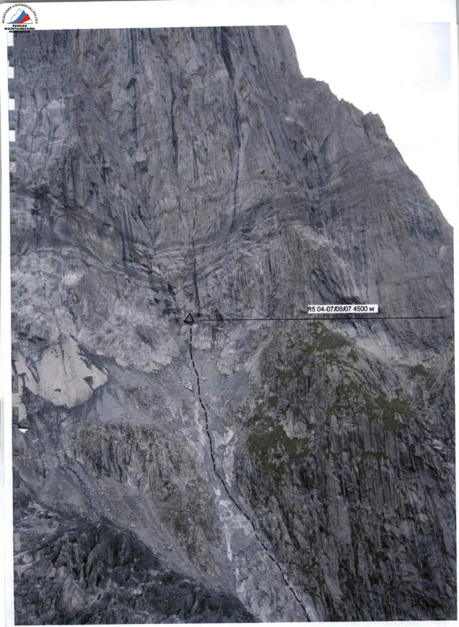
R5, August 4–7, 2007, 4500 m.
Technical photo of the route.
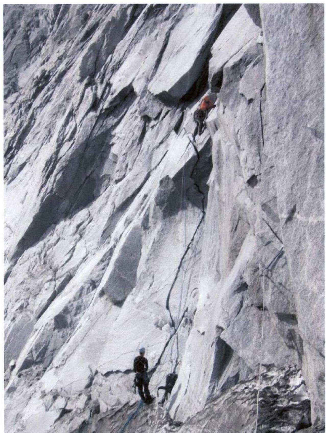
Photo 1. A. Klenov — transitioning from section R6 (slit) to section R7.
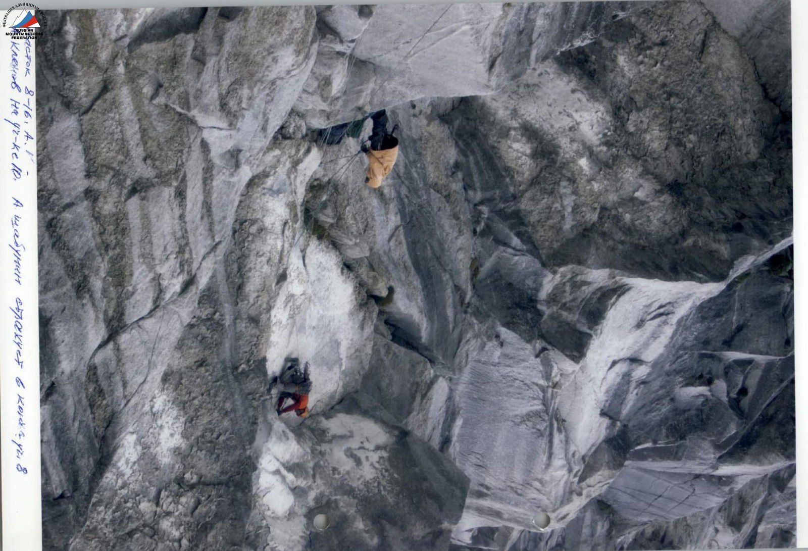
Klenov on section R10. A. Shabunin belays at the end of R8.
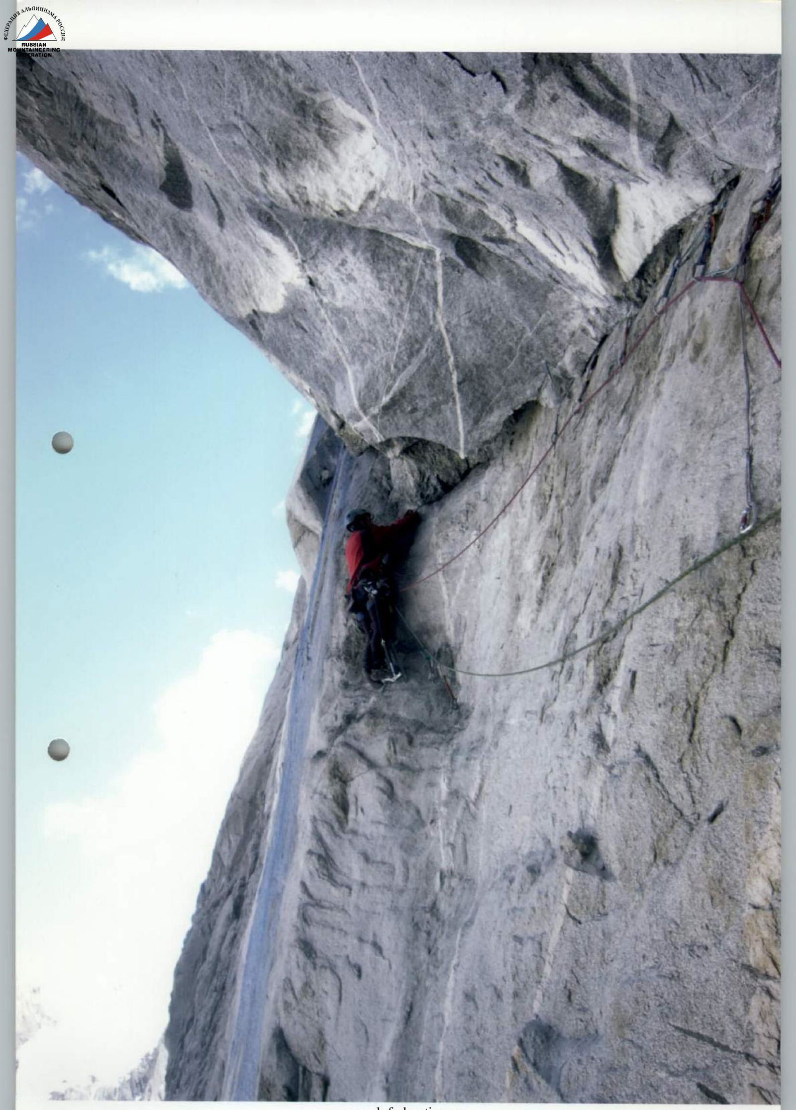
Klenov.
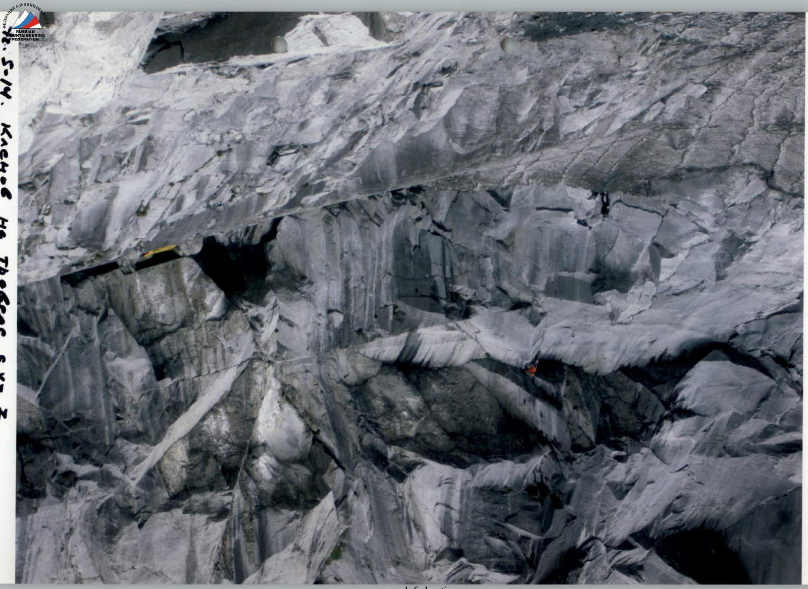
Section R78.
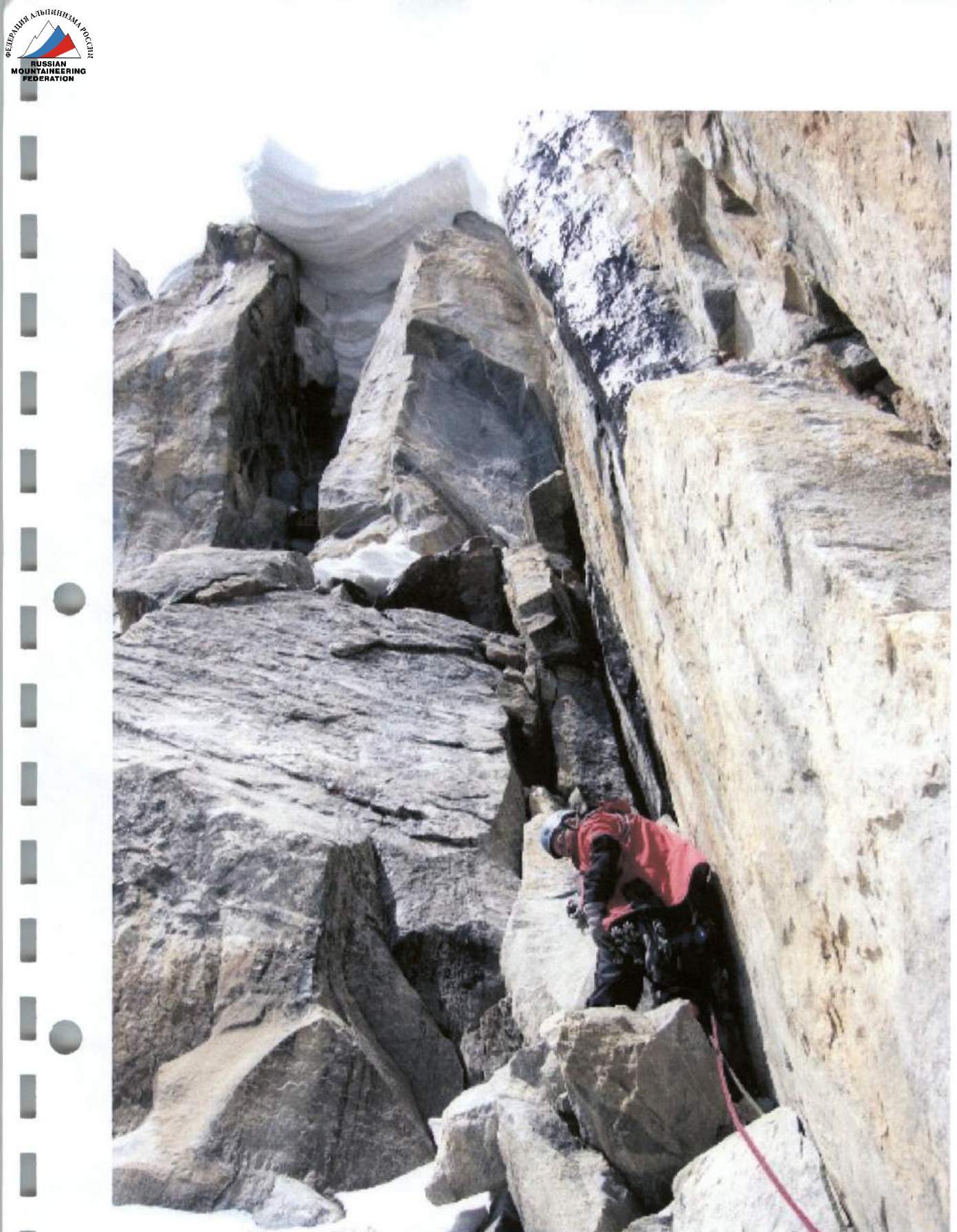
Photo 10. Sections R81–R85. M. Devi leads on section R82.
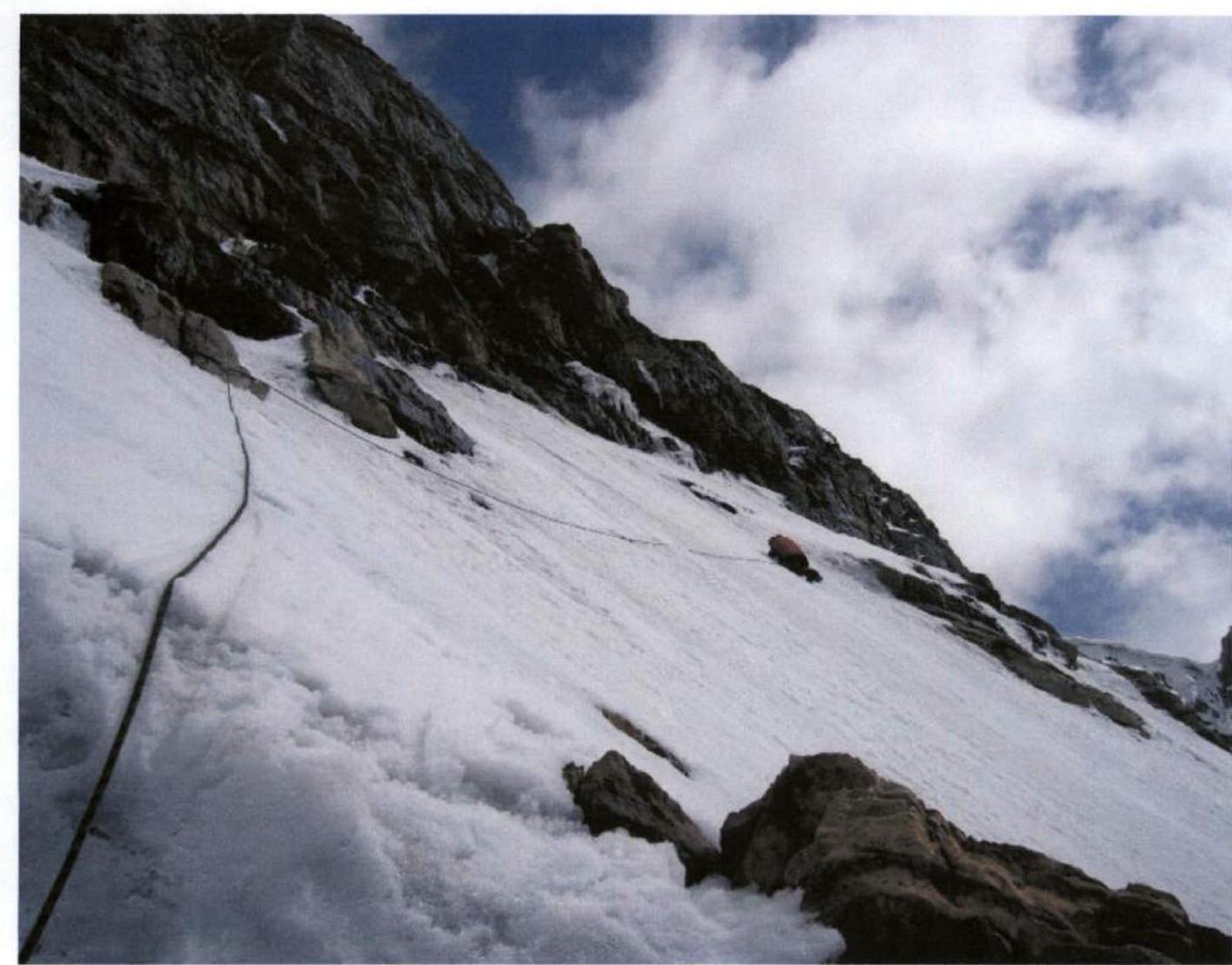
Photo 11. Sections R86–R88. M. Devi leads on section R86.
Comments
Sign in to leave a comment