
PASSPORT
-
High-altitude class
-
Western Himalayas, Diamir gorge
-
Nanga Parbat peak — 8125 m via Diamir Wall (Kinshofer route)
-
Proposed 5B category of difficulty
-
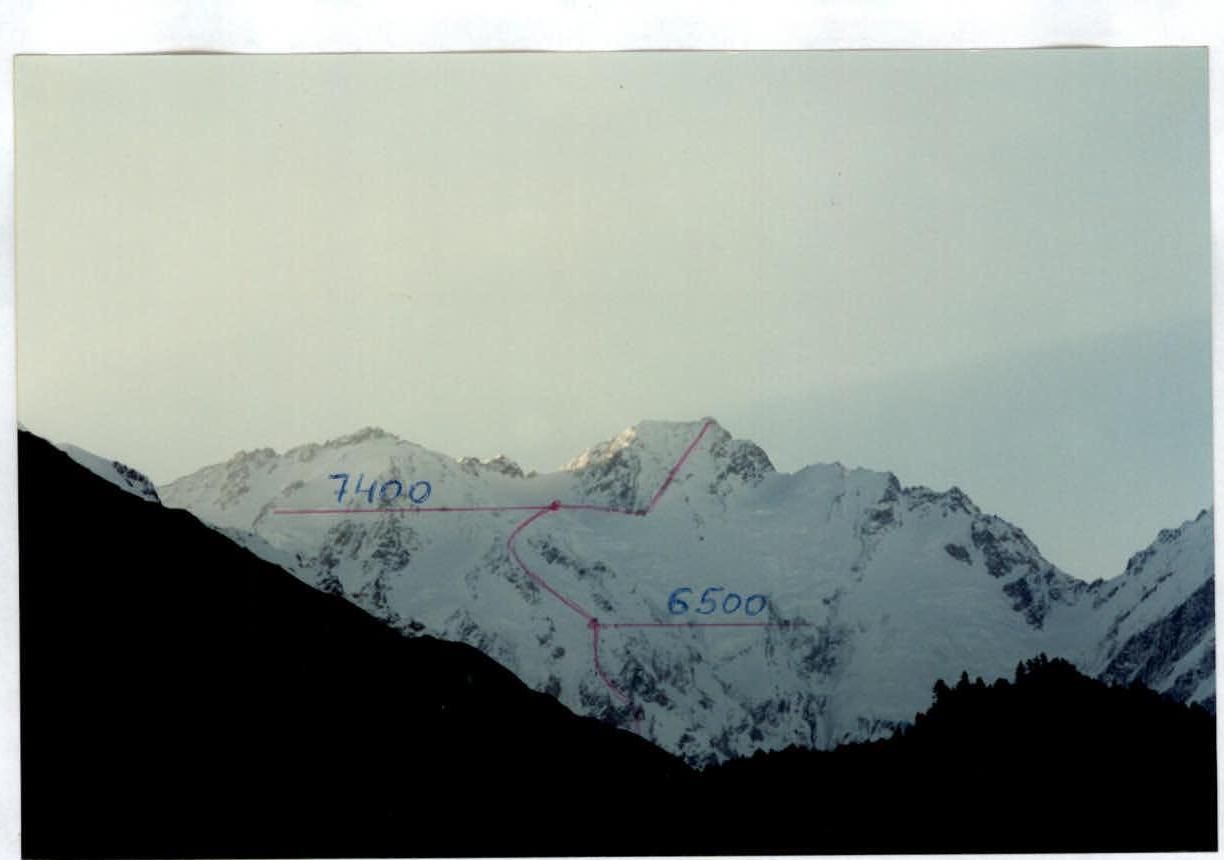
Elevation gain: from glacier — 3800 m, length — 4760 m. Length of 6A category sections — 120 m. Average steepness of the main part of the route — 45° (from camp at 5100 m to the summit). Steepness of the wall section (from 5400 to 6200 m) — 60°.
-
Hooks left on the route (not removed) — 37. Previously hammered hooks used and not removed — 26.
-
Team's working hours — 38.
-
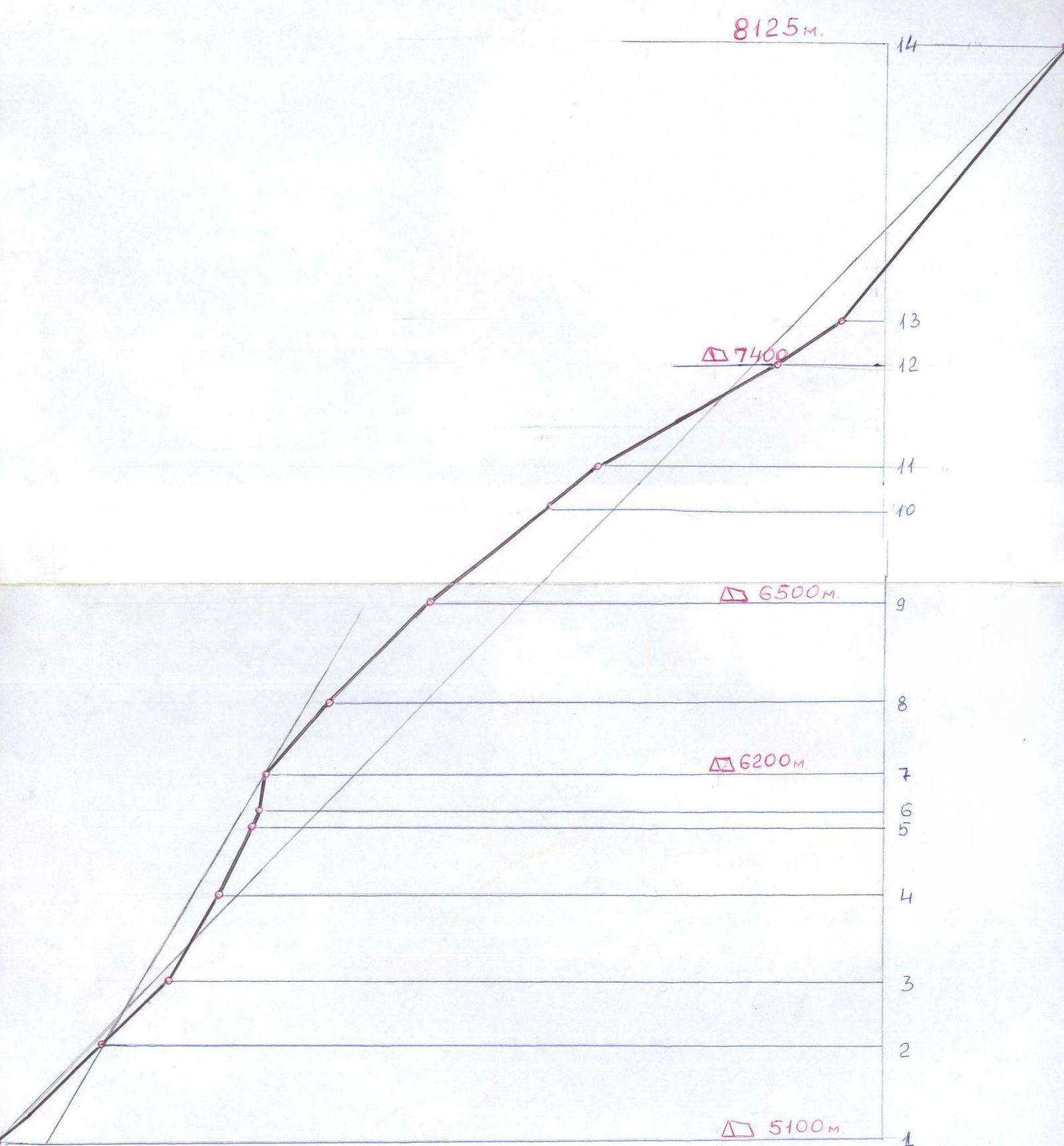
Overnights: 1 — on snow slope — 5100 m; 2 — carved on snow-ice ridge — 6200 m; 3 — on snow slope — 6500 m; 4 — on ice-firn slope — 7400 m. All overnights in "Kangchenjunga" type tent.
First group:
- Leader: Ivan Trofimovich Dusharin — Master of Sports of International Class. Members:
- Carlos Buhler — climber from the USA.
- Andrey Nikolayevich Mariev — Candidate for Master of Sports.
Second group:
- Viktor Grigoryevich Kolesnichenko — Candidate for Master of Sports.
- Andrey Yevgenyevich Volkov — Master of Sports of International Class.
-
Coach: Ivan Trofimovich Dusharin.
-
Departure to the route:
- first group: July 9, 1997.
- second group: July 14, 1997. Return:
- first group: July 14, 1997.
- second group: July 19, 1997.
Shooting location — Base Camp area (4300 m). Distance to the start of the route is about 5000 m. Taken with a "Pentax" camera with variable focal length.
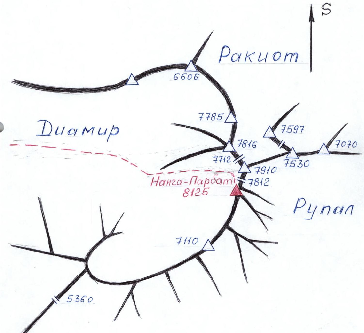
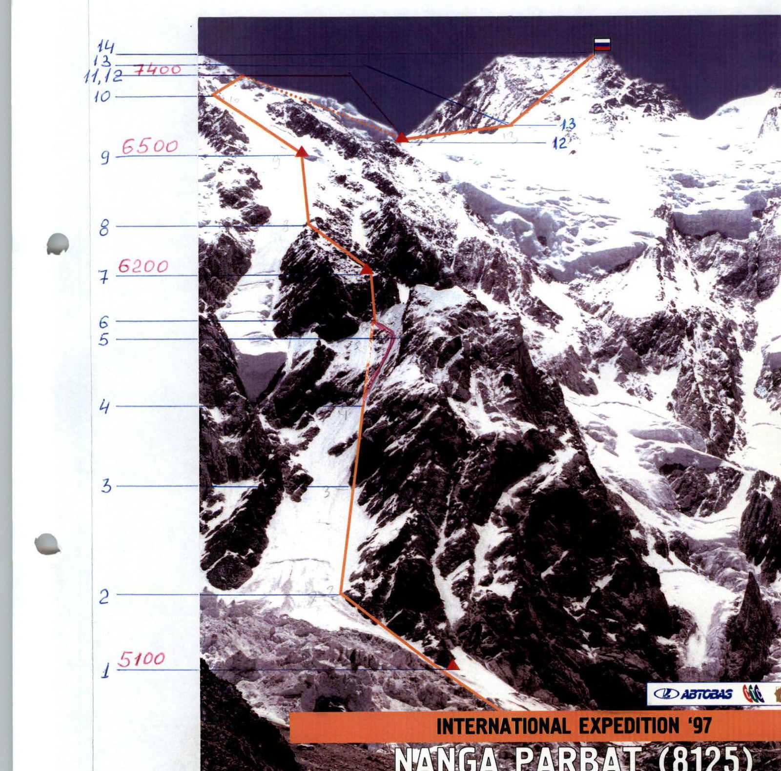
Map of the ascent area
Triangle — peaks. — ascent route.
Nanga Parbat, Diamir Wall
Ascent route profile (drawn)
Brief overview of the ascent area
Nanga Parbat peak is located in the Western Himalayas on the territory of Pakistan. The path to the summit begins in the city of Islamabad, where all organizational issues of the expedition are resolved.
From Islamabad, travel by car via the Karakoram Highway to the village of Chilas (450 km from Islamabad). Further, from the village of Chilas to the village of Bunardas, where a caravan of porters is formed from local residents and the trail to the Base Camp under Nanga Parbat begins.
From the village of Bunardas, the trail goes to the village of Diamarey, located at the beginning of the Diamir gorge. Then, through the Diamir gorge, move to the Base Camp. The journey from the highway to the Base Camp takes 3–4 days; the trail in the gorge is beaten into the slope and allows pack animals to move.
Overnights on the trail are under the open sky. In the villages, there is no civilization. The gorge is harsh, the mountain slopes are rocky, and vegetation is practically absent.
The Base Camp is located at 4200 m; the camp clearing is covered with grass. The approach to the wall to R1 on the route from the Base Camp takes 3–4 hours in good glacier conditions.
Preparation for the ascent
Familiarization with the object of ascent was done through foreign literature. More detailed acquaintance with the ascent route was made according to the description compiled by the Italian team that passed the route on the Diamir Wall on Nanga Parbat in 1992. The recommendations given in the description proved to be very useful and relevant.
The main problem in preparation was obtaining a permit. This problem was resolved by our American partner Carlos Buhler — a professional climber, who also paid the initial permit fee.
The training process consisted of a cycle of general physical preparation, a 10-day stay in Prielbrusye in January 1997, with an attempt to ascend Elbrus (weather did not permit), ice training on the Kashka-Tash glacier, and rock training on local rocks in the Samara Luka area.
Based on the description, we understood that the route on Nanga Parbat via the Diamir Wall is technically challenging and requires the use of the entire arsenal of equipment and the team's readiness to work on steep icy rocks at a significant altitude. The training process was built accordingly. The team had a complete set of necessary equipment, some of which was brought by Buhler from the USA.
The tactical scheme of movement along the route assumed early departures on the route; this especially applies to sections between R1 and R2, the main wall part of the route, which is bombarded by rocks and ice fragments, especially in the second half of the day and in warm weather.
Acclimatization took place during the processing of the ascent route and the establishment of intermediate camps.
Communication with the Base Camp was carried out using portable Japanese-made radios. In addition, the expedition had a satellite phone, which allowed constant communication with Tolyatti and Moscow about everything that happened during the expedition.
The support group was located in the Base Camp during the ascent.

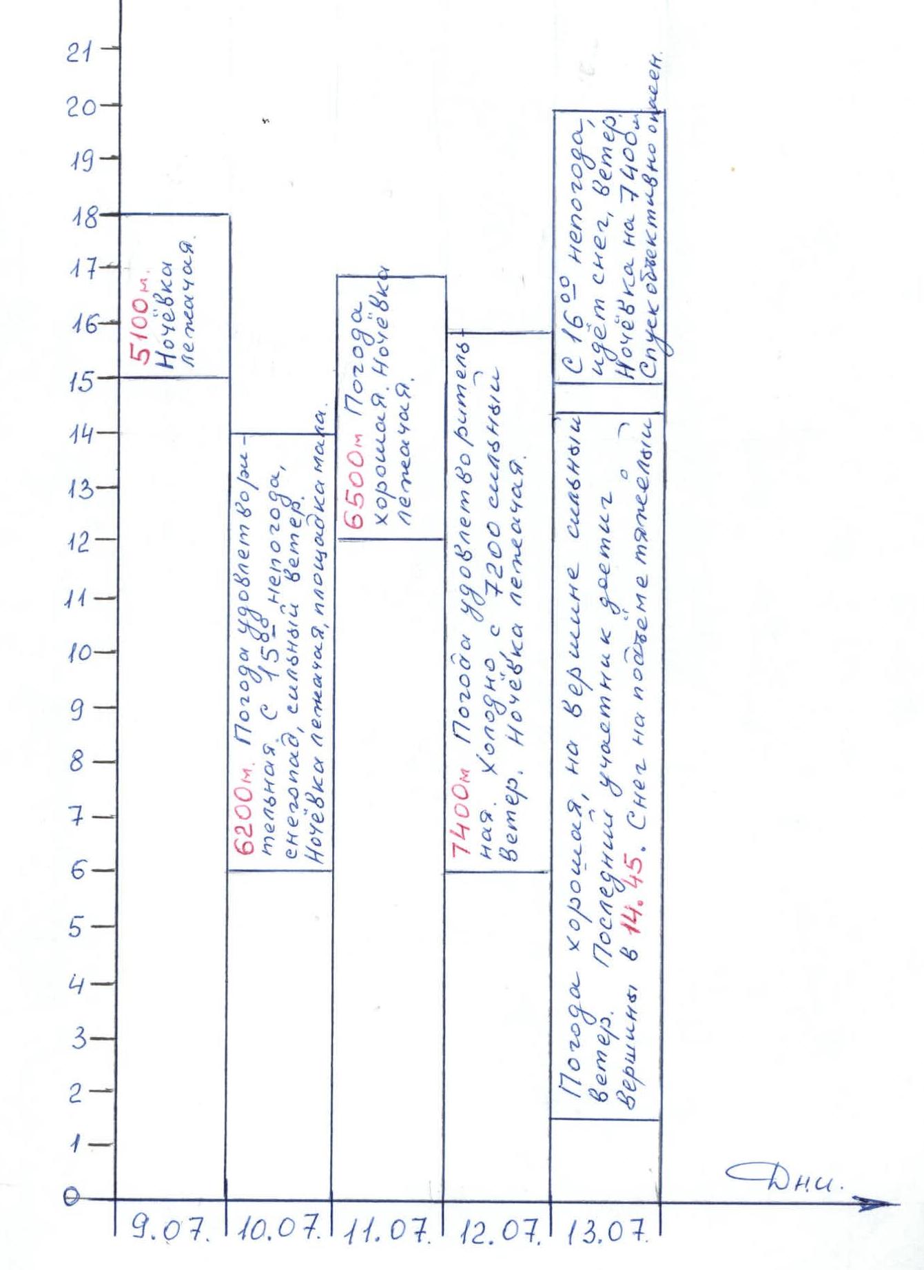
Ascent schedule (first group)
Team's tactical actions
The tactical plan for working on the route assumed during the acclimatization exits:
- processing the ascent path;
- securing the route with fixed ropes;
- establishing intermediate camps and providing them with everything necessary.
Everything listed was done up to R3 at 6500 m, precisely during active acclimatization. Above 6500 m, there were no acclimatization exits, and R4 at 7400 m was established during the summit push, which was a deviation from the accepted Himalayan tactics but was dictated by the logic of increasing safety and the situation on the route.
During the processing of the route and the ascent itself, the following rope teams were formed:
- Dusharin–Mariyev;
- Buhler–Dosayev;
- Volkov–Kolesnichenko.
Although the rope teams mixed during the work.
The team had more than enough necessary equipment for the given route, which allowed them to pass the route reliably.
On the route, there is no free choice of a place suitable for rest (bivouac). The relief allowed setting up camps in strictly defined places, so the transitions between them are not the same in terms of:
- distance;
- time taken;
- technical difficulty.
Overnights are relatively safe, but under certain circumstances, they may be threatened by avalanches, except for R2 (located on a ridge).
The most technically challenging part of the route between R1 and R2 is passed using ice tools and hook protection. The rock wall before R2 is passed using artificial technical means (ITM) and duralumin ladders. When moving with a load, it is advisable to move along it using two jumar ascenders, as the wall is icy, and moving in crampons on ladders is difficult.
The team as a whole and the rope teams, when working independently, had stable radio communication with the Base Camp on Japanese-made radios. The route is mostly in direct visibility from the Base Camp.
In all intermediate camps, "Kangchenjunga" tents were set up, and they were provided with:
- sleeping bags;
- gas;
- food calculated for 3 days for 4 people.
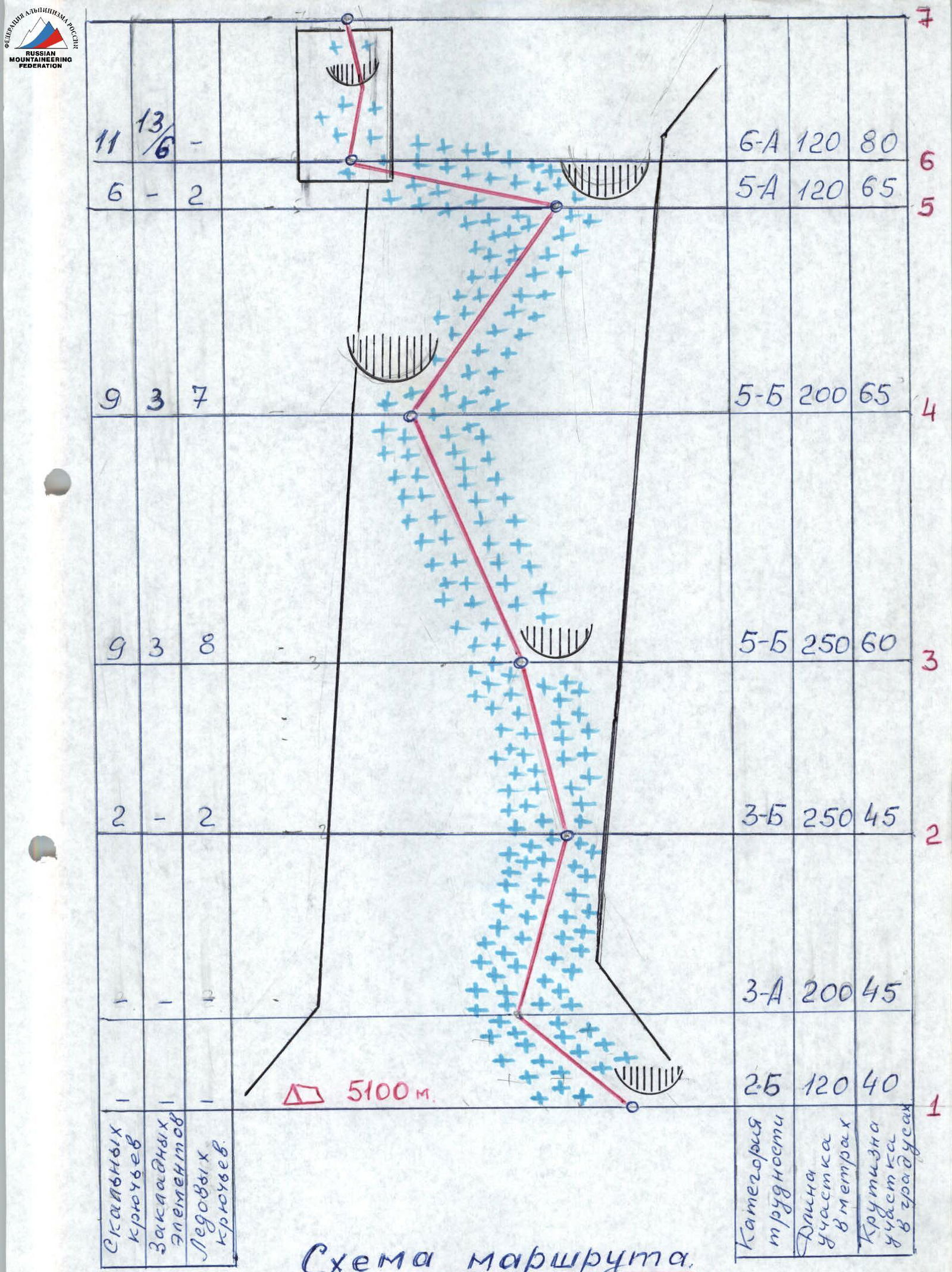
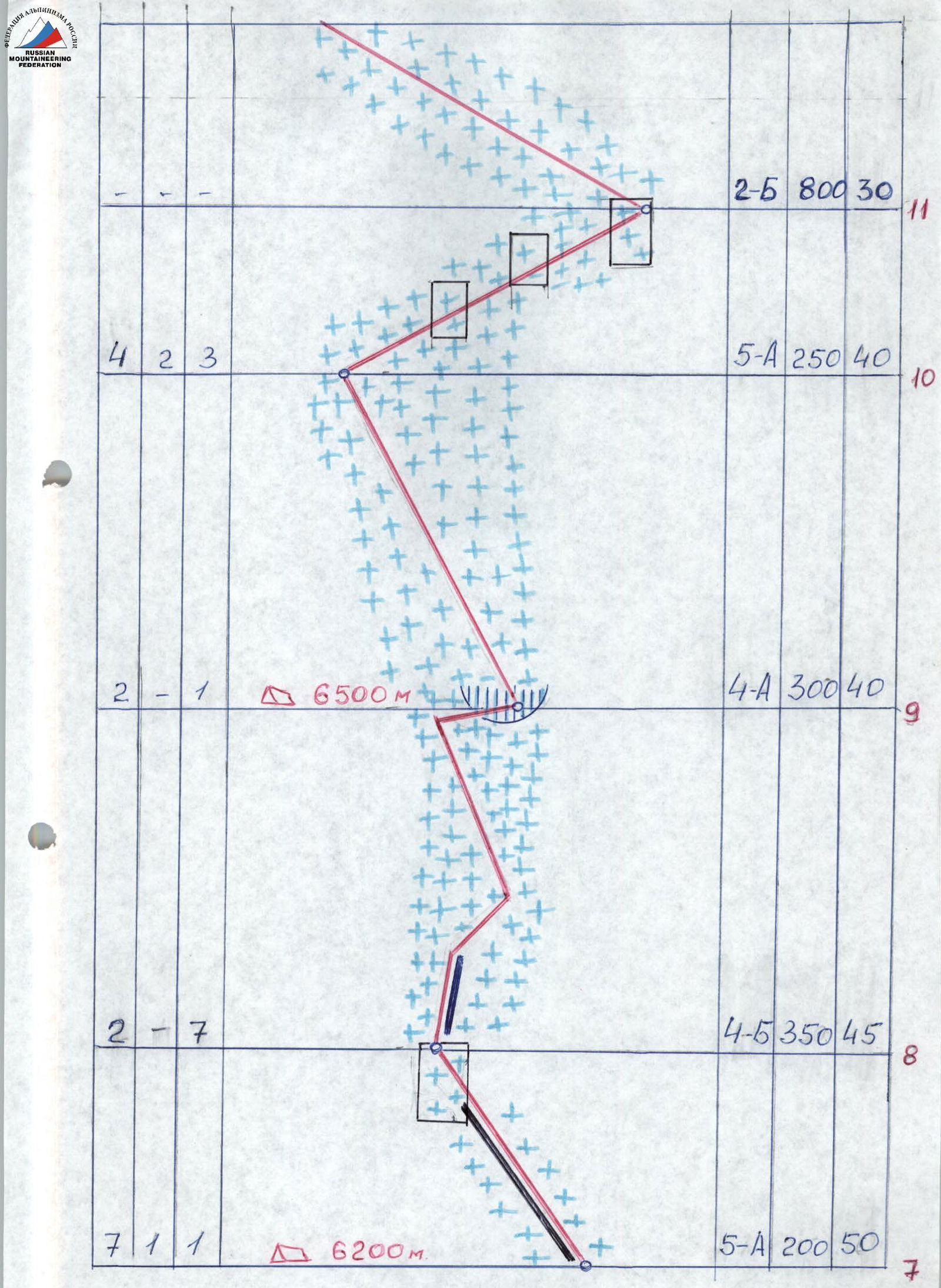
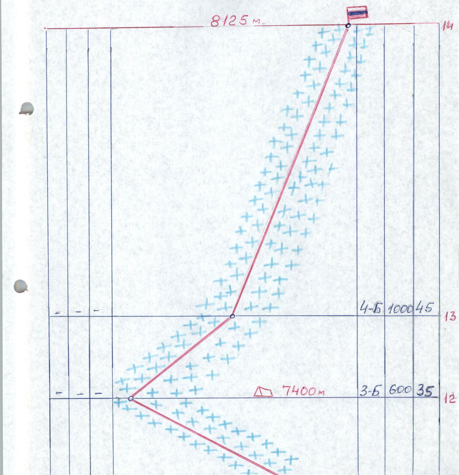
Route diagram.
Description of the route by sections
| Section # | Technical characteristics |
|---|---|
| R1–R2 | Snow slope with crevices and avalanche debris, passed along the rocks. |
| R2–R3 | Snow-ice slope. Movement in crampons with ice tool. At rocks, fixed ropes, hook protection. |
| R3–R4 | Steep ice slope with sections of rocks covered in ice. Movement with alternating protection, using ice tools. |
| R4–R5 | Steep flow ice, protection into rocks and via ice screws. Movement using ice tools. In warm weather, water flows. |
| R5–R6 | Steep snow-ice slope with rocky outcrops. Crossing a wide chute. Movement with ice tools. |
| R6–R7 | Vertical wall, rocks with flow ice, many icicles, small cornices. Passed using ITM. |
| R7–R8 | Ridge covered in snow, with sections of ice. Movement with alternating protection. Hook protection into rocks. |
| R8–R9 | Snow ridge turning into a steep snow-ice slope. Protection via ice screws. |
| R9–R10 | Snow slope, crust does not hold. With a large amount of snow — avalanche hazard. |
| R10–R11 | Traverse across snow-covered and icy rocks with hook protection, exit into a giant snow-ice bowl. |
| R11–R12 | Traverse along the slope of the snow-ice bowl, movement through deep snow, местами плотный фирн. |
| R12–R13 | Approach to the base of the summit pyramid and bypassing it on the left along the rocks. |
| R13–R14 | Ascent along the slope of the summit pyramid. Steep snow slope with rocky outcrops. Exit to the summit via broken rocks. |
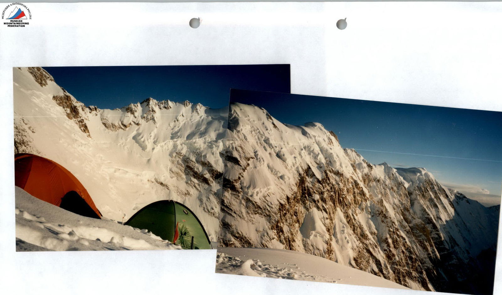
Right wing of the Nanga Parbat massif. View from R3 at 6500 m.
Nanga Parbat from the Diamir gorge (upper part of the route shown).
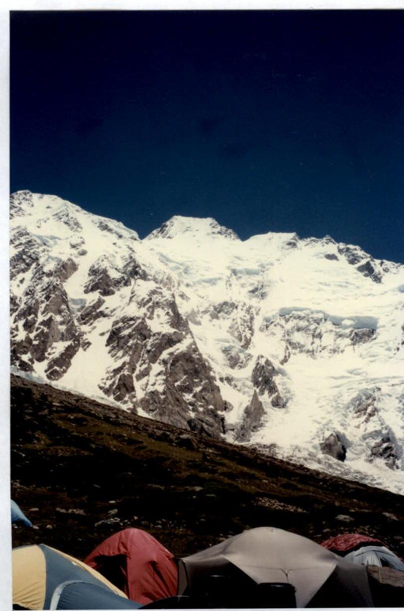
View of Nanga Parbat from Base Camp at 4200 m.
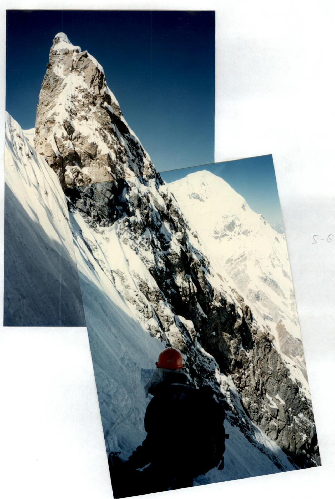
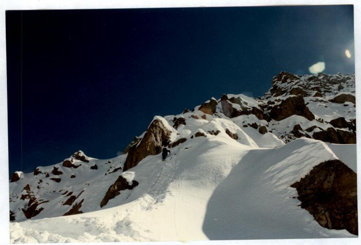
On the R5–R6 section.
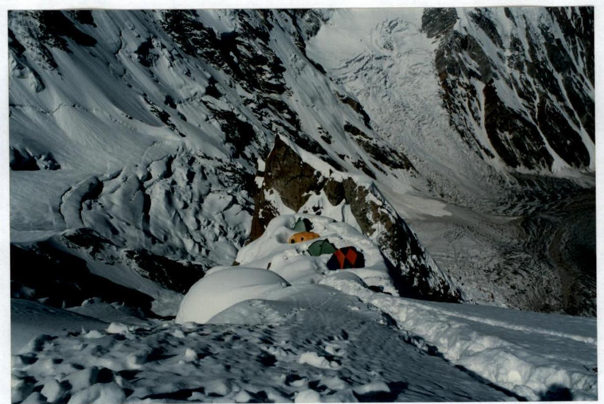
R2 camp at 6200 m.
R7–R8 section.
Comments
Sign in to leave a comment