
Ascent Passport
-
Karakoram mountain system
-
Broad Peak, 8048 m
-
Category of difficulty — 5B
-
West Ridge of the North Ridge, Austrian 1957, combined
-
Route height difference — 2946 m.
Route length — 5714 m.
-
Pitons used on the route (Korean expedition pitons): total — 52 left on the mountain — 52
| rock | ice | shl | snow | El. anchors |
|---|---|---|---|---|
| 22/0 | 0/0 | 0/0 | 18/0 | 0/0 |
-
Climbing hours on the route: 65.5 hours
-
Team composition: Zhumaev M. — Candidate for Master of Sports, captain
Pivtsov V. — Master of Sports of International Class, Chumakov D. — Candidate for Master of Sports, Urubko D. — Master of Sports of International Class, Raspopov A. — Candidate for Master of Sports, Lavrov S. — Honored Master of Sports, Litvinov V. — Candidate for Master of Sports
-
Team coach Ilyinsky E.T. — Honored Master of Sports of the USSR, Honored Coach of the USSR and Kazakhstan
-
Approach to the route — July 14, 2003 at 09:30
Summit — July 16, 2003 at 10:00 — July 17, 2003 at 08:30 — July 18, 2003 at 08:00
Descent to Base — July 19, 2003 at 14:00
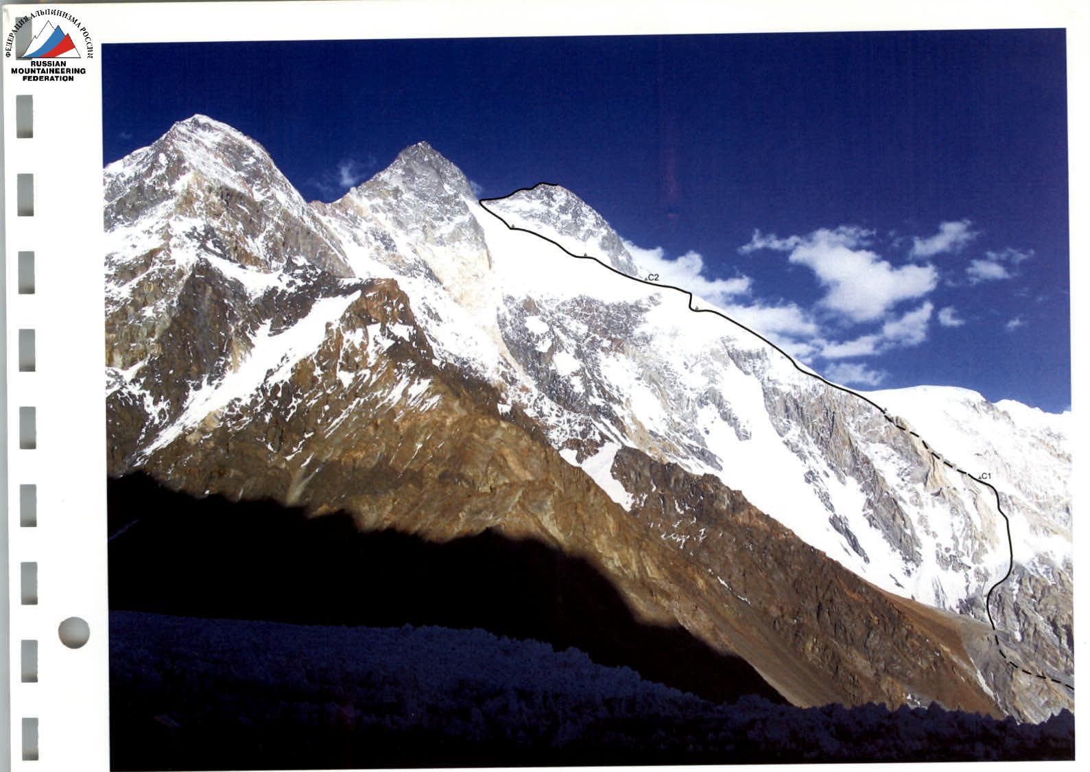
Ascent area map

Concordia
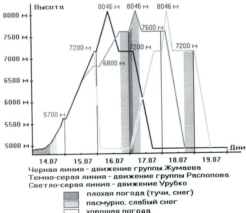
Ascent schedule
Brief description of the ascent area
The Karakoram mountain uplift is one of the largest in the world, ranking second in height after the Himalayas. It is located in Central Asia, in a mountainous knot that connects the Himalayas, Hindu Kush, Tian Shan, and Pamir into a single whole. In terms of area and extent, it undoubtedly yields to many mountain ranges — the Cordillera, the Andes, etc. The system of ridges has a somewhat elongated character from west to east, without a clear orographic pattern.
The character of the mountains here is alpine — with sharp peaks and steep rocky walls with a large height difference. This is due to the youth and strength of the constituent rocks. Granites are predominantly found here. The process of mountain formation, which began with the shift of two continental platforms, the Indostan and Asia, continues, and its intensity outpaces the process of erosion.
The weather conditions are poor, characterized as extremely unstable. The location of Karakoram on the boundary of climatic zones (the Takla-Makan desert, the highlands of Tibet, and the plains of Pakistan open to the southern humid monsoon) contributes to the precipitation of a huge amount of precipitation, accumulated in the form of glaciation. Sharp deterioration of weather and high avalanche danger are frequent phenomena here.
The highest peak of Karakoram is Chogori (K2, Godwin Austin) — 8611 m. There are also three other peaks exceeding 8000 m: Hidden* (8068 m), Broad (8046 m), and Gasherbrum 2 (8035 m).
Karakoram — mountains known since ancient times, as they are located near the first centers of civilization. Nevertheless, their study remained very superficial for a long time due to the inaccessibility of the inner regions. Several branches of the Great Silk Road passed through the gorges of the mountain range, but only in the early 20th century did the first researchers appear, deliberately expanding knowledge about Karakoram.
Among climbers, the following are most popular here:
- the Trango area, whose rocky towers attract with their steepness and scale
- Chogori, whose reputation as a "killer mountain" attracts climbers
- Broad Peak and Gasherbrum, the relative accessibility of ascents to which allows one to hope for success even for not very well-prepared athletes
The simplest and well-established scheme of the path to the foot of the "eight-thousanders" passes along the Karakoram Highway from Islamabad to Skardu, from where all-terrain vehicles — to the village of Askole (about 60 km). The further path of the expedition usually takes 5–6 days on foot, although it is possible to be airlifted by helicopter. From Askole, trekking passes through the village of Paiyu to the Baltoro glacier, along which to the Base camps of either K2 or other peaks.
* also known as Gasherbrum 1
Preparation for the ascent
The team of the ЦСКА MO RK undergoes year-round constant training in all types of mountaineering activities. In the spring of 2002, a successful Kazakhstani expedition to Kangchenjunga (8586 m) took place, when the ascent (including route processing and camp installation) was completed in 18 days. In the summer of 2002, the national team trained on Lenin Peak (7146 m), after which in the autumn of 2002, a Kazakhstani expedition to Shisha Pangma (8046 m) took place, which achieved success in 14 days. In preparation for the 2003 season, it was decided to conduct winter training camps at the Tuyuk-Su sports mountaineering base. The autumn-winter period was characterized by intense physical special loads, as well as regular ascents in the Tuyuk-Su area (from 16 to 46). It was then that the choice fell on Broad Peak as one of the objects of the planned ascents within the framework of the program "Kazakhstanis on the highest peaks of the world." In the spring, the senior coach of the National Mountaineering Team, E. T. Ilyinsky, determined and established the team's composition according to sports criteria (competitions on the rocks and several runs). During the preparation for the ascent, materials regarding the object of ascent were collected and analyzed. The experience of conducting an expedition in 2001 to the peaks of Hidden and Gasherbrum 2 made it possible
Ascent execution
to take into account all the nuances of weather and tactics. Recommendations were also received from Mstislav Gorbenko and Roman Boyur on the nature of the route. Based on all this, the group selected the necessary equipment and developed a route passage tactic.
On May 22, 2003, the first group of the Kazakhstani national mountaineering team departed on a flight via Shymkent to Dubai, and then to the capital of Pakistan — Islamabad. These few people, including the expedition leader B. Zhunusov, carried out all the preparations and paperwork. On May 28, the remaining participants of the expedition arrived in Islamabad and immediately departed for the Base camp of Nanga Parbat. The ascent to this eight-thousander and organizational issues continued until July 5, 2003, after which the team headed to the Base camp (4900 m) on the Baltoro glacier under K2. They arrived there on July 12 after a short trek (K2 and Broad are located nearby, so it is possible to organize one Base camp for ascents to both peaks), and on July 14, they set out on the slopes of Broad Peak. The acclimatization gained on Nanga Parbat allowed for an alpine-style ascent.
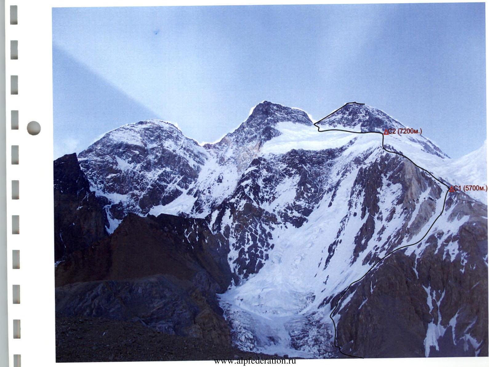
Seven team members were divided into two groups: Zhumaev–Pivtsov–Chumakov–Urubko and Raspopov–Lavrov–Litvinov (the second group was accompanied by Russian expedition participant Bogomolov S., while the other foreign participants acted independently). They ascended with an overnight stay in Camp 1 (5700 m), and then bypassed Camp 2 (6400 m) — higher. Along the way, a tactical division occurred, and the Zhumaev group reached Camp 3 (7200 m) earlier — on July 15, while the Raspopov group stopped on the slope between Camp 2 and Camp 3 at an altitude of about 6800 m. Unfortunately, on that evening, J. Lafaille, a foreign participant in the Kazakhstani expedition, fell seriously ill in Camp 3 after attempting the summit. After providing first aid, he headed down accompanied by his friend E. Viesturs and Kazakhstani Urubko. By morning, they reached the Base camp.
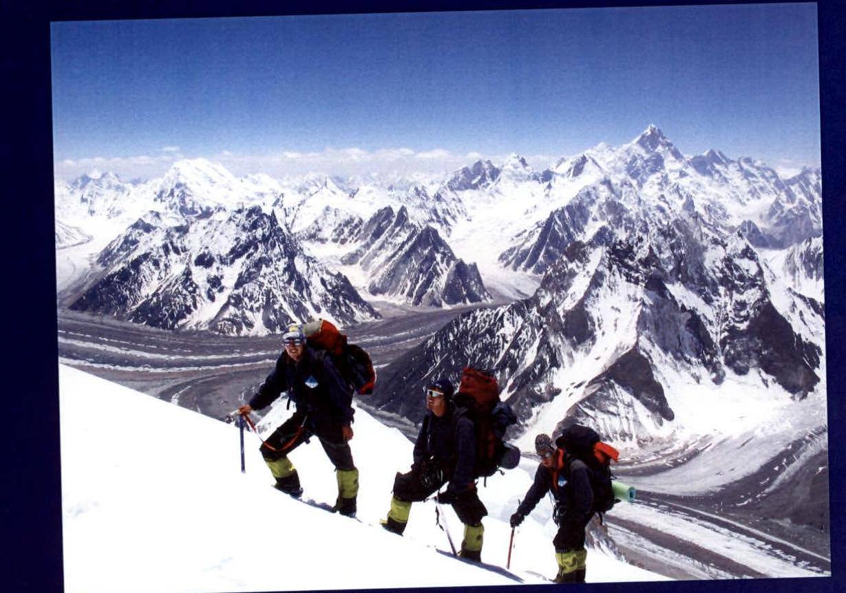
The Zhumaev–Pivtsov–Chumakov group started the summit push at 00:00 on July 16. The snowy slopes were snowed over, and so they had to re-tread the path. By the time they reached the summit ridge, dawn was breaking. The further path lay along the rocky ridge with steep snowy ascents. The weather was good, only windy. And at 10:00 on July 16, the trio reached the top of the Main summit of Broad Peak (8046 m). The descent was made along the ascent route, and at 15:00, they arrived in Camp 3, where they stayed overnight. To further ascend K2, it was necessary to consolidate acclimatization. The Raspopov group, insuring the assault trio, ascended to Camp 4 at an altitude of 7600 m that day.
On July 17, Raspopov–Lavrov–Litvinov–Bogomolov set off upwards at 02:00. Weather conditions were somewhat worse (cloudy and strong wind) than the day before, but the participants advanced upwards. The summit was reached at 08:00. After that, the participants descended along the ascent route to Camp 4, where they stayed for another overnight stay. The Zhumaev group descended to the Base camp that day. Urubko, starting alone from the Base, reached Camp 3 in the afternoon (such a decision was made due to the presence of fixed ropes on the route and participants of the second assault group in Camp 4).
On July 18, having started the assault at 02:30, Urubko reached the summit at 08:00, and by 10:30 descended to Camp 3 for the night. The Raspopov quartet safely reached the Base camp.
The next day, Urubko arrived at the Base. The assault on Broad Peak by the Kazakhstani team was completed. There were no failures, injuries, or illnesses. Radio communication with the Base was carried out regularly at 08:00, 14:00, and 18:00.
Ascent analysis
Urubko D. — a good, working ascent, the route was completed by the team without any complaints or problems. "Thanks to the guys for the tea in Camp 4 early in the morning when I was on the assault".
Zhumaev M. — in my opinion, the ascent was very competent. All transitions between camps were chosen rationally and logically, which allowed maintaining a high pace on the assault day. The successful ascent scheme of all groups allowed maintaining group autonomy and successfully conducting rescue operations during the descent of J. K. Lafaille.
Chumakov D. "I consider the ascent to Broad Peak to have been successful, without injuries or frostbite. The equipment was chosen correctly and met modern standards, which helped a lot. We worked in a coordinated manner, and especially I would like to note the good and confident insurance of each other during the ascent days".
Pivtsov V. "Everything went wonderfully, both in terms of organization and ascent execution. The team had excellent relations, and we worked towards a common success. The equipment was chosen competently".
Lavrov S. "I believe that under the circumstances:
- The ascent was carried out with maximum safety.
- The tactics were developed competently.
- Interaction with foreign groups was at a good level.
- Radio communication and overall electrical support of the expedition were at the required level.
- The firm's personnel worked well, special thanks to the cook, who managed to provide good food at the Base.
- Rest and recovery during the break between ascents were sufficient.
- All participants were focused on work and achieving the goal".
Raspopov A. "The experience of organizing the Karakoram-2001 expedition helped in conducting the Karakoram-2003 expedition. Therefore, difficulties with the caravan during the approaches to the mountain were resolved in a businesslike and calm manner. All high-altitude camp deliveries were carried out normally, there were no shortages, and unnecessary work was not performed".
Ilyinsky E. "The alpine-style ascent to Broad Peak was fully justified. The ascent, overall, was carried out competently, at a high pace. Once again, the team proved that in addition to the ascent itself, help and mutual assistance on the mountain are important. Leadership and ascent — to be counted. To all participants — improvement of physical and technical training".
Route scheme in UIAA symbols
(AIT was not used)

| № | Steepness | Length | Difficulty | Pitons | |
|---|---|---|---|---|---|
| rock | snow | ||||
| 1 | 90° | 4 m | IV | 1 | |
| 2 | 30° | 150 m | I | 2 | 2 |
| 3 | 40° | 150 m | II | 1 | 2 |
| 4 | 60° | 40 m | III | 1 | |
| 5 | 40° | 200 m | I | ||
| 6 | 35° | 100 m | - | ||
| 7 | 40° | 350 m | I | 2 | |
| 8 | 45° | 300 m | II | 1 | 3 |
| 9 | 35° | 120 m | I | ||
| 10 | 35° | 200 m | III | 2 | 1 |
| 11 | 40° | 200 m | II | 2 | 1 |
| 12 | 45° | 150 m | III | 2 | |
| 13 | 30° | 300 m | I | ||
| 14 | 35° | 150 m | I | 1 | |
| 15 | up to 60° | 400 m | II–III | 5 | |
| 16 | 30°3 | 400 m | I | 5 | |
| 17 | 30°3 | 300 m | I | 1 | |
| 18 | 40° | 200 m | I | ||
| 19 | 30° | 200 m | II | 1 | |
| 20 | 35° | 150 m | I | ||
| 21 | up to 45° | 800 m | I | ||
| 22 | 45° | 150 m | II | 1 | |
| 23 | up to 65° | 450 m | III | 3 | |
| 24 | 30° | 250 m | II |
Section 11, altitude about 6800 m

Section 11, altitude about 6800 m

Section 13, altitude about 7100 m

Camp 2 (7200 m)

Comments
Sign in to leave a comment