Ascent Log
- Nepal, Himalayas, Khumbu region, section No. 10.1 of the mountain peak route classifier
- Peak name: Cholatse (Cholatse), route name: via the right bastion of the north face
- Proposed - 6B category of difficulty, first ascent
- Route type: combined
- Route height difference: 1640 m (by altimeter)
Route length: 2030 m. Section lengths:
- V category of difficulty — 1175 m
- VI category of difficulty — 445 m
Average steepness:
- Main bastion — 67°
- Entire route — 63°
- "Hooks" left on the route:
total — 0; including pitons — 0
Hooks used on the route:
- stationary pitons — 0, including for artificial climbing holds (ACH) — 0
- removable pitons — 1, including for ACH — 1
- rock hooks (including anchor hooks) — 82, including for ACH — 13
- camalots — 49, including for ACH — 13
- chocks — 2
- ice screws — 114
Total artificial climbing holds (ACH) used — 47, including 21 ACH on fiffes;
- Team's climbing hours: 84 hours, 8 days
- Team leader: Valery Pavlovich Shamało, Master of Sports
Team members: Alexander Borisovich Gukov, Candidate for Master of Sports; Viktor Alexandrovich Koval, Candidate for Master of Sports
- Coach:
Oleg Viktorovich Kapitаnov, Master of Sports, 1st category instructor
- Departure to the route: 5:00, March 13, 2010
Reached the summit: 14:00, March 20, 2010. Descent from the summit to Gokio valley: 14:30, March 22, 2010. Return to Base Camp: 15:30, March 24, 2010.
General photo of the summit
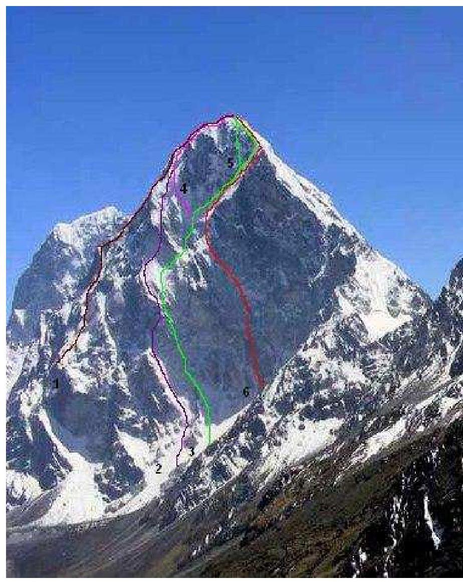
North face of Cholatse peak. October 2009, taken from the approach to Chola Pass, above Dzonghla village, at an altitude of about 5000 m. Existing route markings on the wall:
- Slovenian variation of the 1984 American route via the northeast face, 2005 (Tomaž Humar, Kozeli, Opresnik), M6, 6A, 90°;
- Korean attempt to climb the wall (up to 6000 m), 2003;
- French route, 1995 (Boris Badaroux, Philippe Batoux, Marc Challamel, Christophe Mora, Paul Robach);
- Swiss variation of the French route, 2005 (Ueli Steck), F5, M6, 90° (nominated for the Golden Ice Axe 2005);
- Korean variation of the French route, 2005 (Park Jung-hun, Choi Kang-sik);
- Route climbed by the St. Petersburg team.

Photo of the wall profile from the left
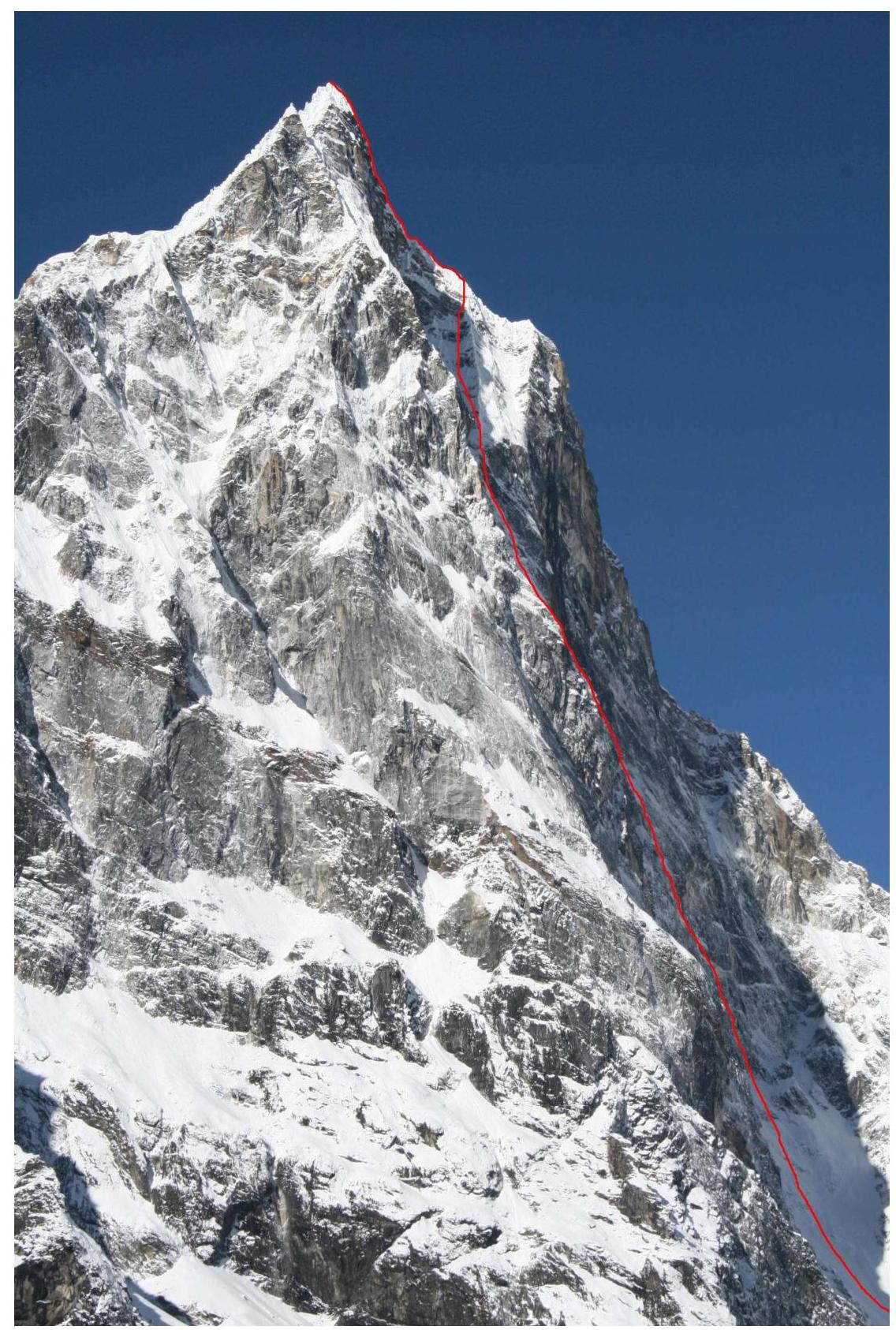
The route climbed by the St. Petersburg team is marked with a red line. Taken from the east, from the slopes of Awi Peak, at an altitude of 4900 m. February 2010.

Panoramic photo of the area
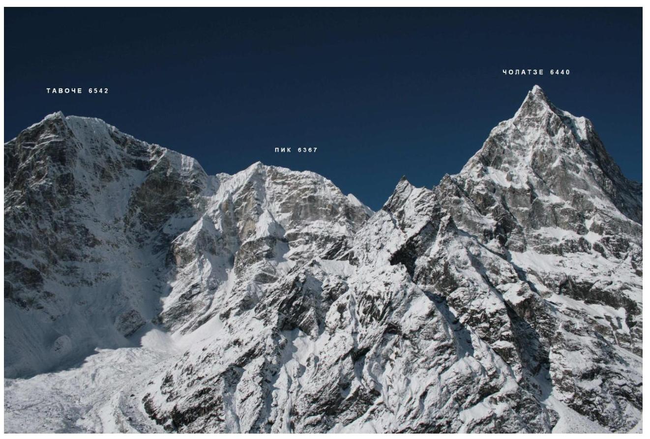
Taken from the east, from the slopes of Awi Peak, at an altitude of 4900 m. February 2010.
Area map
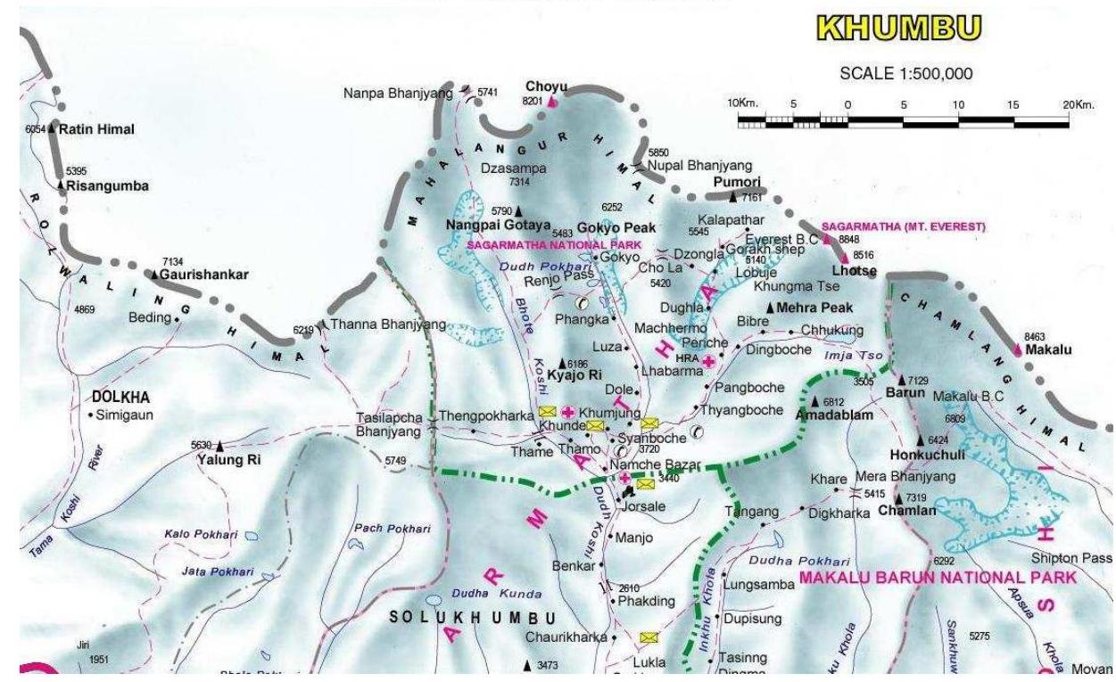
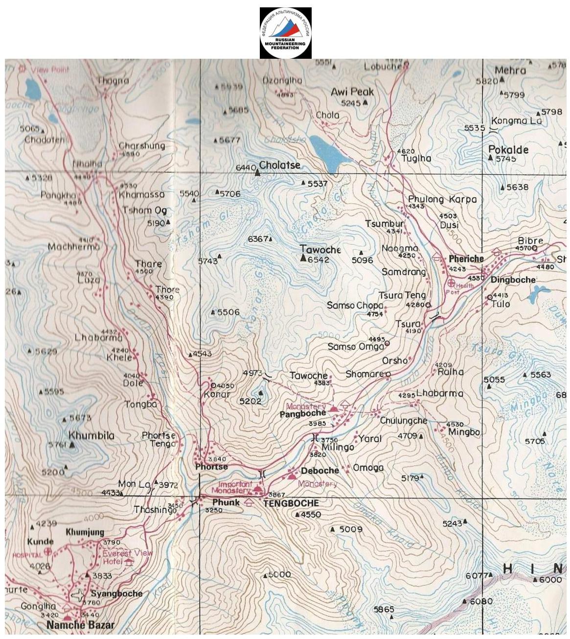
Overview of the climbing area
The Cholatse peak (6440 m) is located in Nepal, in one of the numerous southern spurs of the main Himalayan ridge, in the Khumbu region (within the Sagarmatha National Park), approximately 20 km southwest of Everest. Several of the world's highest peaks are nearby — Everest, Lhotse, Makalu, Cho Oyu, visible from the summit and some nearby viewpoints:
- Everest
- Lhotse
- Makalu
- Cho Oyu
Climatic conditions are favorable for ascents in spring and autumn, as the area is dominated by monsoons in summer and late autumn, with significant snowfall and lower temperatures at high altitudes. Weather becomes more stable towards the end of winter and in spring, starting from March, with rare snowfalls and gradual warming. Most expeditions take place in April-May, primarily because it is still quite cold in March.
A very popular trekking trail for tourists and climbers passes through the Khumbu valley, a few kilometers from the peak, leading from the road and Lukla airport to the base camps under Everest and Lhotse. To the north of the peak, at an altitude of about 4590 m, lies a lake slightly over a kilometer long. In winter and March, it is more convenient to approach the north face across the frozen lake.
Despite the relatively straightforward approach, there have been only a few ascents to Cholatse peak:
- The first ascent was made by an American group in 1982 via the southwest ridge.
- Later, in 1984, another ascent was made via the northeast face and ridge.
The north face remained an unresolved challenge for a long time. Several attempts were made by Korean groups. We are aware of only three successful ascents via the face, all of which followed the central ice couloir.
The upper part of the couloir splits into two:
- To the right, a smaller couloir leads to the northwest ridge, ending at a rock and ice wall.
- To the left, a steep ice slope leads to the ridge and then to the east ridge.
In 1995, a French group made the first ascent of the north face, exiting onto the northwest ridge.
In 2005:
- A Korean duo made their own variation, exiting to the summit via an ice gully to the left of the northwest ridge.
- The French route was repeated by renowned Swiss climber Ueli Steck, who made a solo ascent and reached the summit via a new variation, traversing a steep snow and ice slope to the east ridge.
Initially, the central couloir may appear straightforward, especially when viewed from below. However, traversing it without protection is actually very intimidating due to the presence of rotten ice and the risk of ice and firn slab avalanches. Credit is due to the bravery of the Swiss climber.
It is advisable to establish the base camp either in Tughla (on the popular trekking route to Everest Base Camp) or in Dzonghla (on the trekking trail from Tughla towards Chola Pass and further into the Gokio valley).
In winter, it is more convenient to stay in lodges.
The journey from the camp in Tughla to the start of the route takes 2-3 hours.
Descent from the summit is advisable:
- to the east towards the col with Tawoche peak and then north.
One can also descend via the relatively straightforward southwest ridge, but this requires:
- a clear understanding of the route,
- or having a photograph of the mountain from the south.
Otherwise, even a slight mistake may lead to the southwest face, potentially prolonging the descent to the Gokio valley by 2 days. A Korean duo made such a mistake and had to be evacuated by helicopter from the foot of the mountain due to severe frostbite and exhaustion.
Our group made a similar mistake but managed to descend without helicopter assistance.
No ascents had been made via the more challenging right section of the north face prior to our climb, despite several attempts, mainly by Korean groups.
Ascent schedule
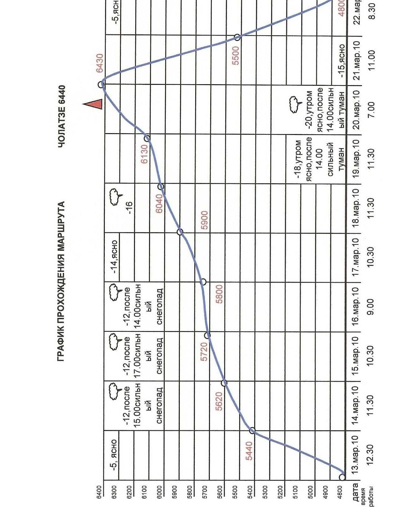
Dates and times of work:
- March 13, 2010 — 12:30
- March 14, 2010 — 11:30
- March 15, 2010 — 10:30
- March 16, 2010 — 9:00
- March 17, 2010 — 10:30
- March 18, 2010 — 11:30
- March 19, 2010 — 7:00
- March 20, 2010 — 11:00
- March 21, 2010 — 8:30
R0–R1 — from the cirque under the base of the north face straight up the steep snowy slope towards the rust-colored rock belt, in the middle of the right bastion. Simultaneous movement;
R1–R2 — up and left through a steep ice couloir, protection via ice screws and rock walls of the couloir;
R2–R3 — snowy rocks, general direction is up and slightly left towards a steep snow-filled couloir;
R3–R4 — snow-filled couloir, difficult climbing, challenges in organizing effective protection, in the upper part of the couloir, move right to bypass a hanging rock;
R4–R5 — steep snowy ledge, traversed along the edge of the wall, effective protection on the rocks to the right, convenient protection ledge at the end of the section. It is necessary to stay close to the wall as rocks periodically fall from the upper part;
R5–R6 — overhanging rocks, overcome with the aid of artificial climbing holds (ACH). "Live" rocks in the lower part of the section. Very difficult climbing. Passage aided by fiffes used for ACH; a removable piton (the only one on the route) was also used for ACH;
R6–R7 — steep snowy slope. General direction of movement:
- right
- up under a huge cornice.
Station under the cornice on its left side;
R7–R8 — traverse under the cornice to the right, by moving camalots into the gap formed between the wall plate and the cornice ceiling;
R8–R9 — after exiting from under the cornice, move straight up through difficult rocks, overcome with the aid of ACH, icy rocks like "ram's foreheads" in the upper part;
R9–R10 — straight up the couloir with an ice gully under a steep rust-colored wall. Under the wall, a platform is carved into the ice, and a bivouac is set up;
R10–R11 — from the bivouac site straight up through a vertical crack via very difficult rocks, overcome with the aid of ACH, then through ice-covered rocks like "ram's foreheads" towards the ice gully going left upwards.
R11–R12 — left and up the ice gully between rocks like "ram's foreheads". The landmark for movement is a huge vertical crack going through the entire upper overhanging part of the bastion;
R12–R13 — through snowy rocks and firn ledges, going left and up along the rust-colored rock belt, towards the overhanging rock, under the protection of which a bivouac is set up;
R13–R14 — continue moving left and up through snowy rocks and firn ledges, leading to the base of a steep rock bastion of yellow-brown color;
R14–R15 — steep bastion, rocks covered in ice, cracks unreliable, "live" rocks, overcome with the aid of ACH;
R15–R16 — ice gully between rocks like "ram's foreheads"; the direction of movement is obviously left and up since:
- the left section is limited by wall drops,
- the right section is limited by the overhanging upper bastion of the wall.
The landmark for movement is a steep ice ridge on the left part of the wall;
R16–R17 — steep snowy slope, ending at a huge rock cornice; under the cornice — a snowy drift, on which a platform is carved for a tent. Lying bivouac;
R17–R18 — traverse left under the rock cornice, then along the boundary between the steep snowy slope and the wall towards the steep ice ridge;
R18–R19 — snowy and icy rocks, movement straight up, at the end of the section, due to bad weather (snowfall, powder avalanches), forced to stop for the night, for which a platform is carved on a steep ice slope. Sitting bivouac;
R19–R20 — steep, heavily snowed rocks, difficulties in organizing effective protection, movement straight up;
R20–R21 — extended snowy slope, ending at the northeast part of the wall, traverse left and up towards the ice couloir going through the entire north wall;
R21–R22 — steep snowy and icy rocks, ending at a vertical wall. Under the base of the wall, a sitting bivouac is set up;
R22–R23 — from the bivouac site, traverse left to bypass the vertical wall)
R23–R24 — ice-covered rocks and vertical rime ice, traversed on ice axes, movement straight up;
R24–R25 — ice-covered rocks and vertical rime ice, traversed on ice axes, movement straight up towards the snowy-ice couloir;
R25–R26 — extended steep snowy slope in the upper part of the right snow-ice couloir (here our route converges with the French route of 1995);
R26–R27 — exit directly into the snow-ice couloir, movement straight up under the rock wall closing the couloir, under the wall a platform is carved for a tent. Sitting bivouac.
R27–R28 — from the bivouac site, right and up through a steep snowy rock wall, exit onto a snowy ridge forming the couloir wall and ending at the pre-summit ridge;
R28–R29 — movement straight up the steep snowy ridge (seracs!), then along the left side of the ridge, exit under a steep rock wall;
R29–R30 — steep rock wall, climbed "head-on";
R30–R31 — snowy rocks, movement straight up towards the pre-summit ridge;
R31–R32 — steep snowy slope, very loose snow, difficulties in organizing protection, not reaching several meters to the summit ridge (cornices!) a platform is carved for a tent. Lying bivouac;
R32–R33 — from the bivouac site, traverse several meters below the ridge (cornices). Very loose snow, effective protection is impossible to organize, only alternate movement!
R33–R34 — about 50 m from the bivouac site, cross to the southwest side of the ridge (cornices on the northeast side!). Movement along a steep snowy-icy slope to the right (in the direction of travel) of the pre-summit ridge;
R34–R35 — from the pre-summit ridge, exit onto a gently sloping snowy field, which is traversed towards the summit;
R35–R36 — along a not very steep short snowy slope, exit to the summit.
After a night on the snowy field under the summit, descend via the southwest ridge and then down the southwest face into the Gokio valley. On the descent, a night is spent at the base of the wall above the glacier snout descending into the valley. After the night:
- traverse the glacier snout,
- cross the glacier,
- descend into the valley via rocks like "ram's foreheads".
Technical photo of the route
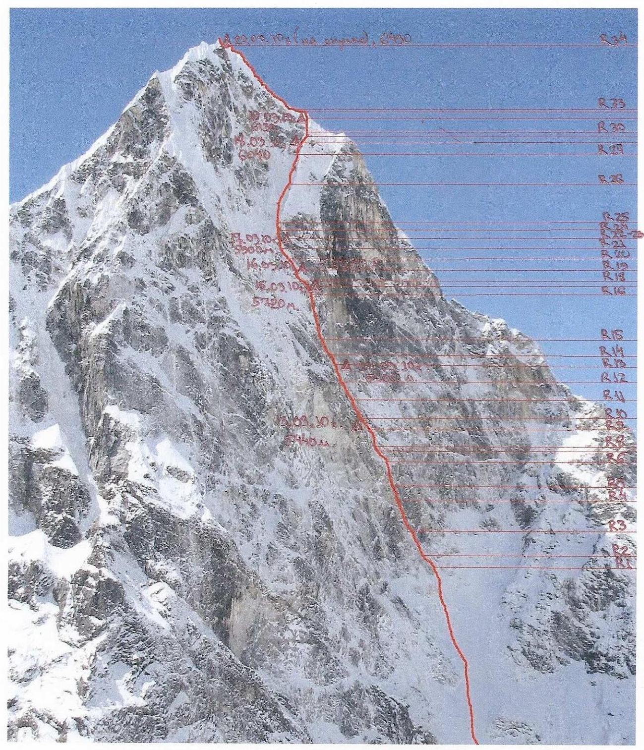
Taken from the east, from the slopes of Awi Peak, at an altitude of 5100 m. February 2010.
Notes from the summit and route
No notes were found on Cholatse summit or along the route. The group also did not leave any notes. Leaving a note on the summit is problematic since it is entirely snowy, and the nearest rocks are at a considerable distance — over 100 m.
Near the point where our route coincided with the French group's route, a left-behind rock hook was found. No other signs of human presence were observed on our route.
The group did not leave any cairns during the ascent.