Ascent Passport
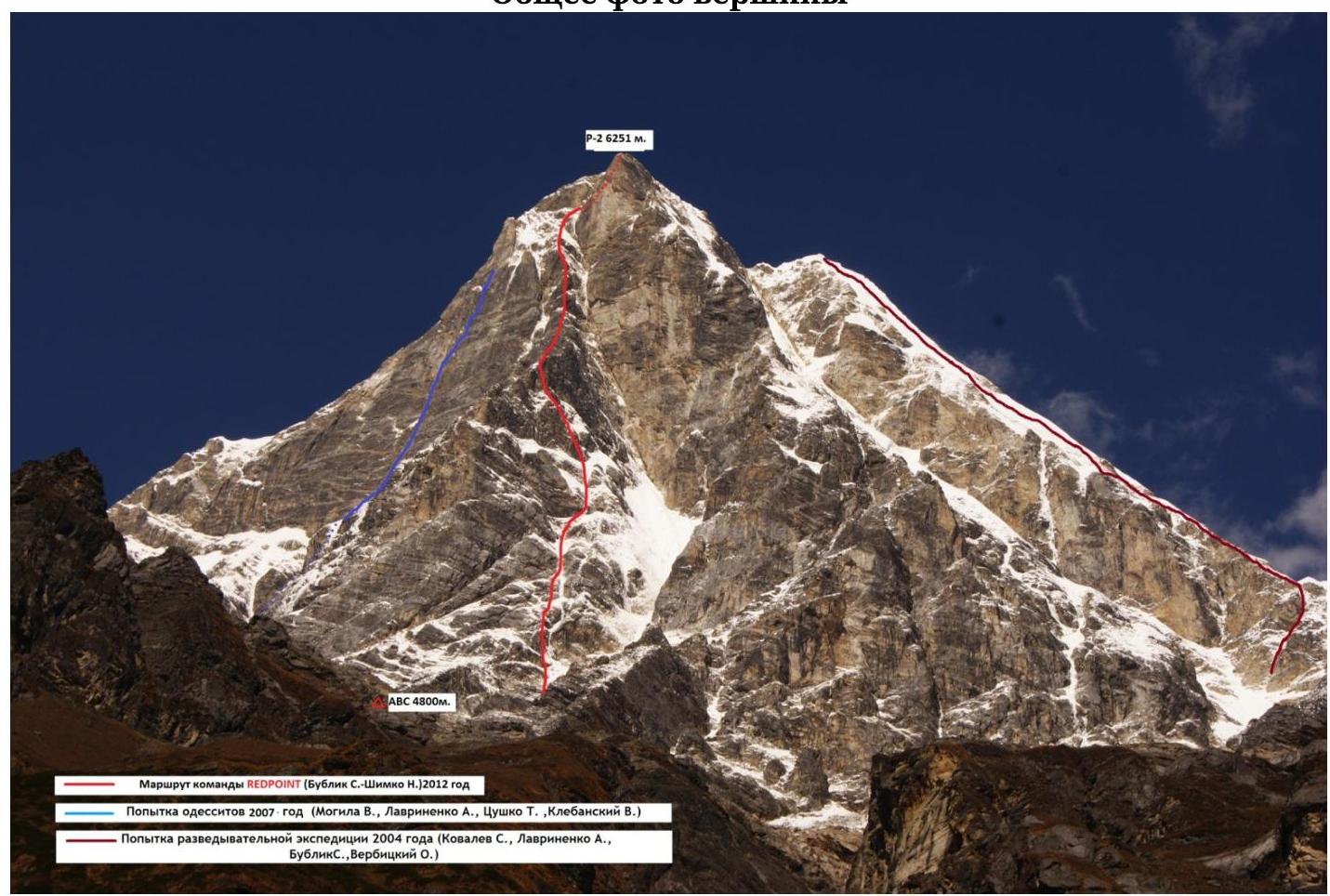
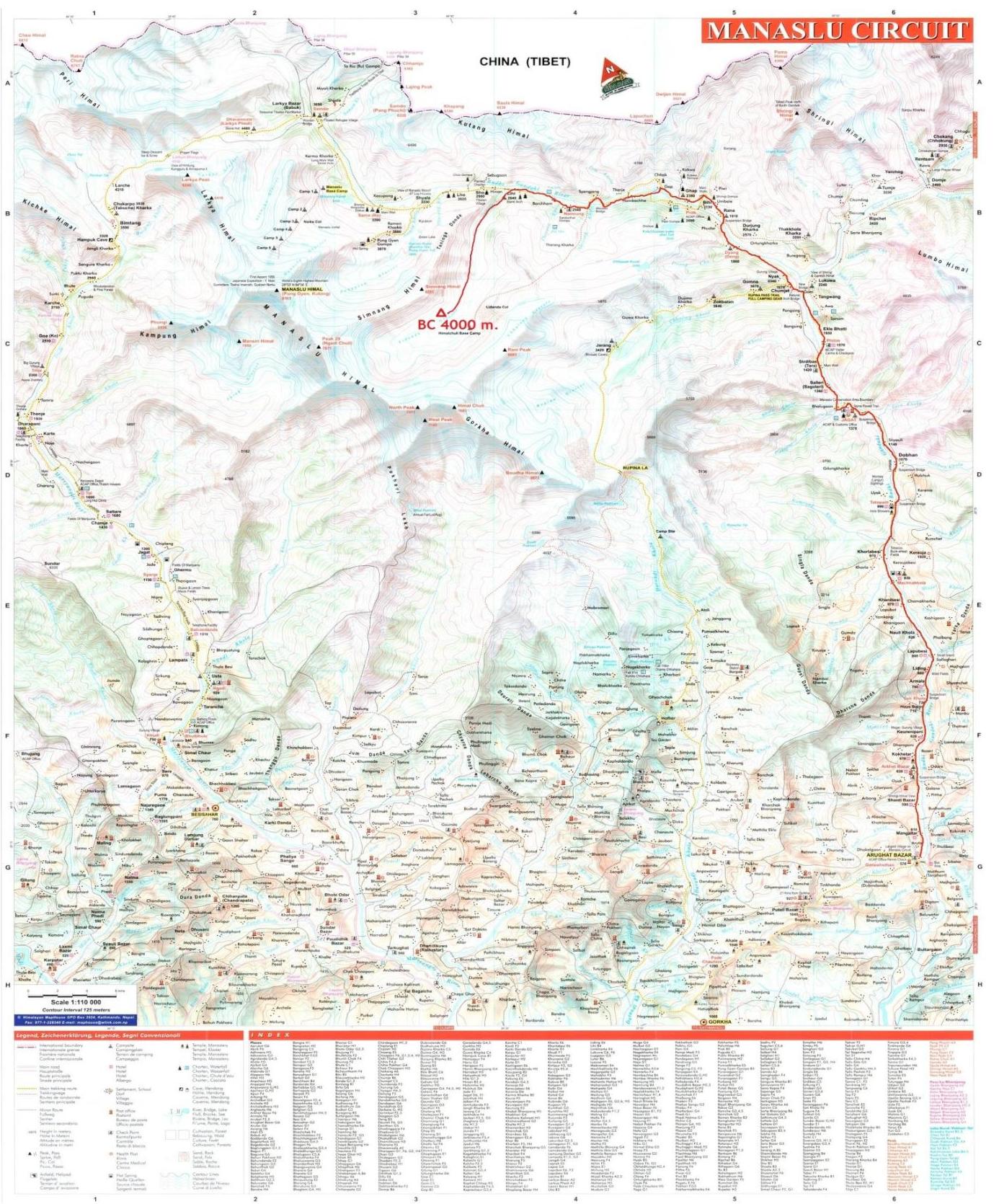
Climbing area — Himalayas, Manaslu area, Liddanda gorge.
- Peak R-2, height (6251 m), via SE ridge
- Proposed — 6A category of difficulty, first ascent
- Route character: combined.
- Height difference of the route: 1254 m (by altimeter)
Route length: 1485 m. Length of sections:
- V category of difficulty — 385 m,
- VI category of difficulty — 350 m. Average steepness:
- main part of the route — 76°,
- entire route — 70°.
- Pitons left on the route:
Total — 4; including pitons — 0. Pitons used on the route: 96, including artificial anchors (AA) — 13.
Used protection elements: 129, including AA — 16.
Used ice screws: 29
- pitons, stationary — 0, including AA — 0
- pitons, removable — 0, including AA — 0
Total artificial anchors (AA) used: 29
- Team's travel hours: 45 hours, 5 days
- Team leader:
Bublik Sergey Yurievich, Master of Sports of International Class
Team members:
- Shimko Nikolay Nikolaevich, Candidate for Master of Sports
- Coach:
Self-coached
- Departure to the route: 4:30, October 19, 2012. Summit attempt: 11:30, October 23, 2012. Return to Base Camp: 21:15, October 23, 2012.
General photo of the summit
Route description October 19 — R0–R1 From the bivouac under the wall, approach the base of the large couloir. Up the snowy couloir with a steepness of 35 degrees, 200 m, staying on its right side. Avalanches come down the couloir! 200 m, 35°, III. R1–R2 Turn left from the couloir and go straight up the icy-snowy slope with a steepness of 45–60 degrees, along the border of ice and rocks, towards the ice chute with steepness up to 90 degrees. 50 m, 60°, IV–V (W12). R2–R3 Bypass the ice chute from the left on mixed terrain until reaching the wall with the ice chute. 120 m, 70–80°, V (M4). R3–R4 Entrance to the ice chute: mixed terrain for 10 m — M5, 85°, followed by a rumbling ice icicle with very thin ice, organizing insurance is problematic W16, 85–90°, 35 m. 45 m, 90°, VI+. R4–R5 Then up the ice chute with a steepness of 70–80°, overcoming an ice step 10 m, 90°, organizing insurance is problematic. 40 m, 90°, V (W15). R5–R6 Move towards the rocky wall along a steep firn couloir, organizing insurance is problematic. Here is a good place for a bivouac. 70–80°, IV+ (W13), 35 m. October 20 — R6–R7 From the bivouac, move up the mixed section 20 m, M6, 80°, insurance is provided by anchor hooks of medium size, followed by an ice section 25 m, W14, 70–85°, 70–85°, V+, 40 m. R7–R8 Move along thin ice, ice screws enter less than halfway. Station under a 4-meter overhang. 80–85°, VI (W15), 40 m. R8–R9 Move along the firn slope towards the rocky ridge. 75°, IV (W13), 35 m. R9–R10 From the station, straight up the complex mixed terrain 10 m, VI (M6), 90°, then to the right up the icy slope to approach the base of a large rocky bastion W13, 70°, 30 m. 70–90°, IV–VI, 40 m. R10–R11 Then up the complex rocks with mixed sections. 85°, VI (6c(+), M6), 45 m. R11–R12 Move towards the large couloir on mixed terrain. 70°, IV (M4), 35 m. R12–R13 Move along the couloir with steep thin ice towards the rocks. Safe place for a bivouac. 80–85°, V+ (W15–16), 80 m. October 21 — R13–R14 From the bivouac, move left up the complex mixed terrain. 80–90°, VI (M6), 40 m. R14–R15 Move up the snowy slope of medium steepness 10 m to the sharp ridge, then along the ridge towards the bastion. 45°, IV+, 40 m. R15–R16 Then up by climbing the inner corner with a small number of AA A1, towards the snowy ledge. 80°, VI, 40 m. R16–R17 Approach the rocky bastion on snow. Climb the bastion straight up. Organizing insurance is problematic. 75°, V+, 35 m. R17–R18 Then along the inner corner with a crack, exiting onto steep "ram's foreheads," insurance is problematic, provided by anchor hooks. 80°, VI(A2), 45 m. R18–R19 — then along the icy slope with rocky walls to approach the rocky wall. Place for an overnight stay. 60°, IV+, 40 m. October 22 — R19–R20 From the bivouac, move left along the ledge 8 m, to the base of a "deaf" crack, up the crack on AA with complex moves (possible free climbing, estimated difficulty 7b/7c). 85–90°, VI+ (A3, 6c), 45 m. R20–R21 Climbing rocks with mixed sections. 70°, IV+ (5b, M3), 40 m. R21–R22 Along complex rocks straight up, the lower part 20 m, is passed with complex AA (A3), then complex climbing (6c) until flattening (possible free climbing, estimated difficulty 7c(+)). 95°, VI (A3, 6c), 40 m. R22–R23 On ice-mixed terrain, move towards the inner corner. 70°, IV(M4), 40 m. R23–R24 Rocky-mixed section. Along the inner corner, exit onto the icy slope. 75°–90°, VI(M4, A2), 30 m. R24–R25 On the snowy slope, move towards the summit. 60°, IV, 40 m. R25–R26 From the summit couloir, traverse left along the snowy slope to the overnight stay location, which is under an overhang. 60°, III, 50 m. October 23 — R26–R27 Ice-mixed section 70°, IV (W13), M4, 35 m.
27–28 — traverse right along rocks of medium difficulty towards the couloir. 70°,
IV, 40 m. 28–29 — up the icy couloir, strictly upwards, overcoming steps with steepness up
to 90 degrees. 80°, V+ (W15), 40 m. 29–30 — up the couloir to the summit. 70°, IV (W13), 40
m.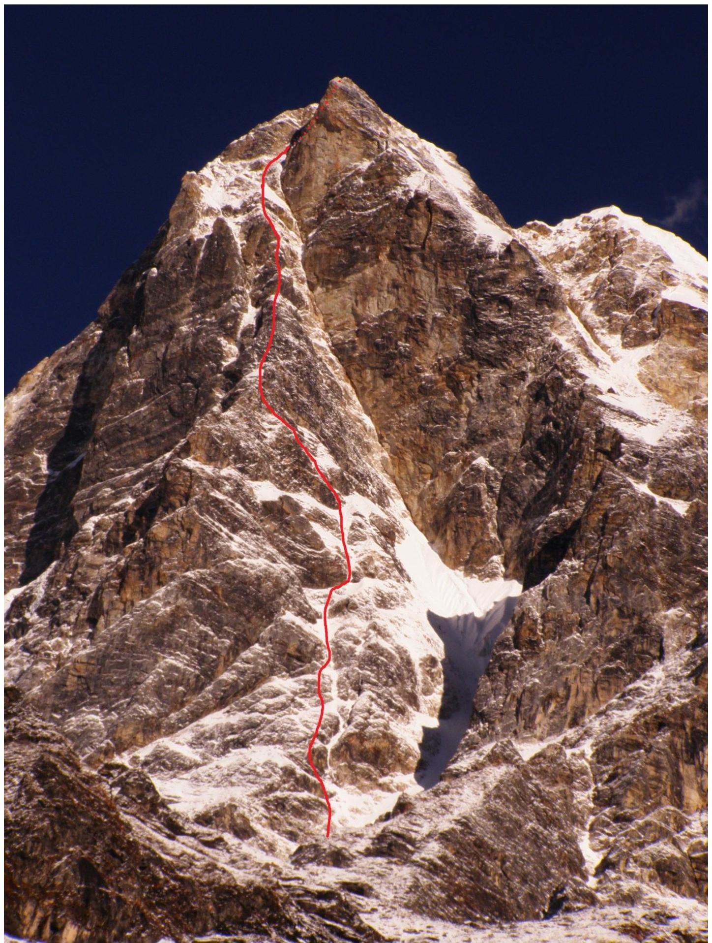
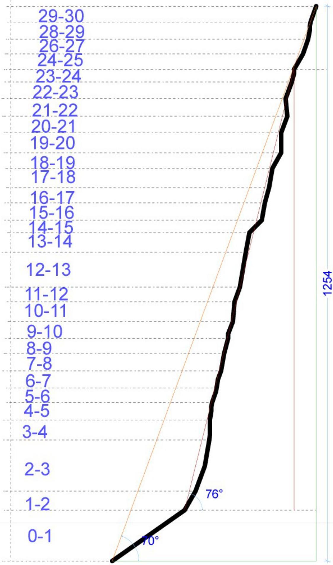
29-30
28-29
26-27
24-25
23-24
22-23
21-22
20-21
19-20
18-19
17-18
16-17
15-16
14-15
13-14
12-13
11-12
10-11
9-10
8-9
7-8
6-7
5-6
4-5
3-4
2-3
1-2
0-1
MANASIU CHICUIJ
| Pitons Kruti Category | Scheme in UIAA symbols | Section № |
|---|
| Pitons | Scheme in UIAA symbols | Section № | For |
| Kochti Category |