
- Central Himalayas, Manaslu-Himal region, Gorkha, Buri-Gandaki river gorge.
- Manaslu peak (8163 m), North-East slope
- Submitted — 6A category of complexity, first ascent
- Route character — combined
- Height difference of the route — 2963 m
Route length — 4754 m. Length of sections:
- V category of complexity — 55 m
- VI category of complexity — 4 m. Average steepness:
- main part of the route (sections) — 68°
- entire route — 42°
- Hooks left on the route: total — 0, drilled — 0
Hooks used:
| Rp | Dr | Ice | Cam. Elem. | Fr | |
|---|---|---|---|---|---|
| Protection | 21 | 0 | 17 | 14 | 10 |
| ITO | 2 | 0 | 0 | 1 | 1 |
- Climbing hours of the team on the route: 39 h 00 min
- Participants:
Uryubko Denis — Master of Sports of International Class, Samoilov Sergey — Candidate for Master of Sports
- Team coaches:
Samoilov Sergey — coach of the Central Sports Club of Kazakhstan, Gorbunov Yuri — coach of the Federation of Alpinism and Rock Climbing of Almaty
- Start on the route: May 4, 2006 — 5:00
Summit: May 8, 2006 — 18:30. Descent to Base Camp: May 9, 2006 — 20:30. Route photo from North-East, at a distance of 3000 meters from the wall.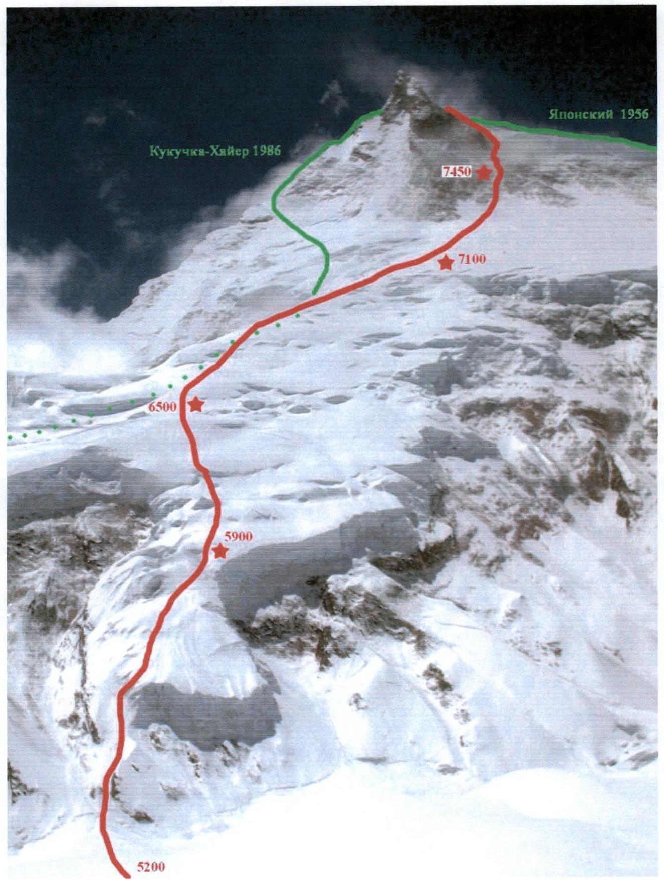 Map-scheme of the ascent area
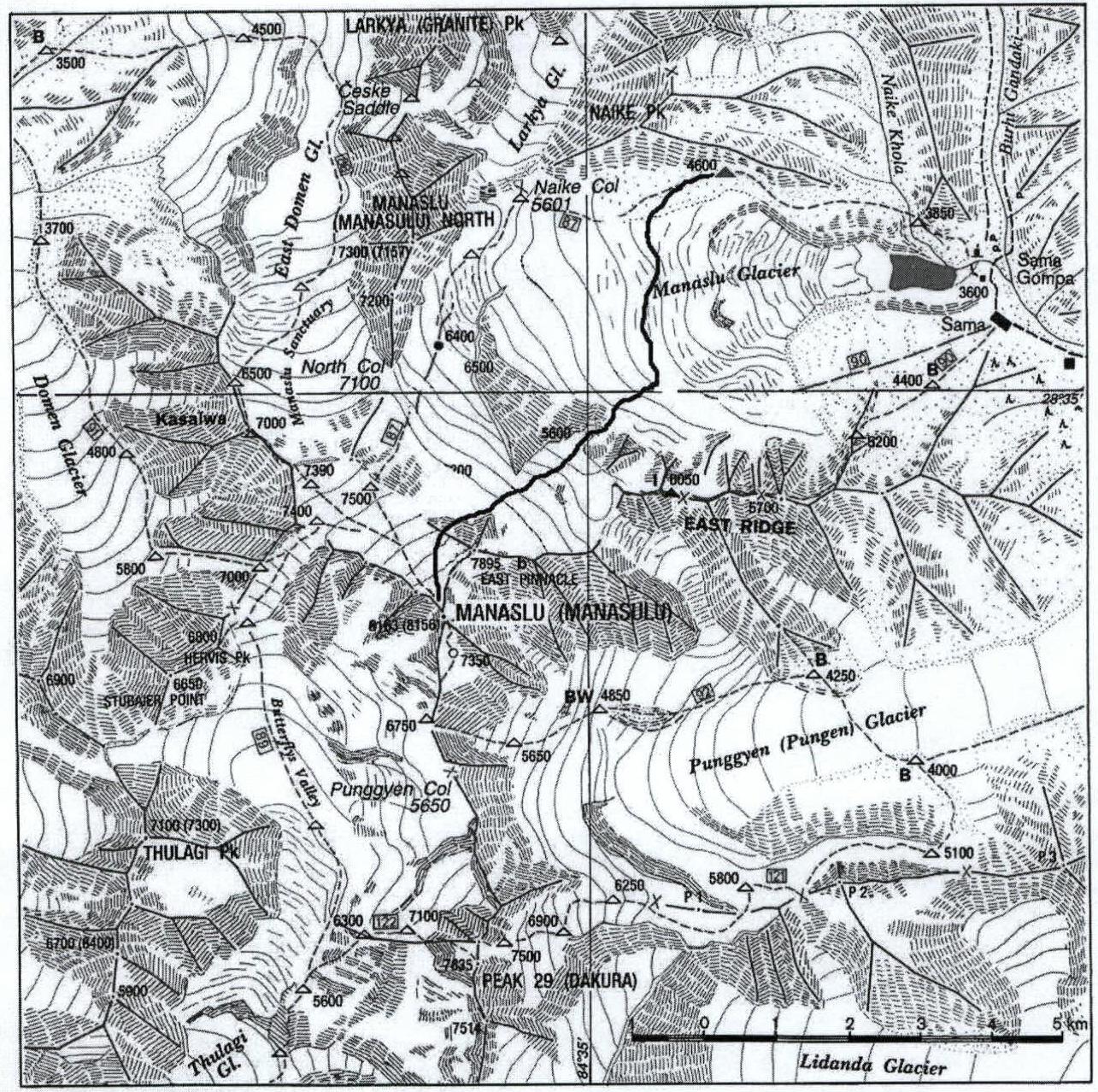
Ascent Graph

Brief description of the ascent area
Manaslu (Manasa in translation from Nepali — «Soul») is the eighth highest peak in the world. Located in the state of Nepal. Situated in the central part of the Himalayan ridge and represents an isolated massif in the form of a plateau 3 km long and up to 1 km wide. It lies at an altitude of 7500 m and is stretched from north-west to south-east, where the highest point of the mountain is located.
The Himalayan mountain system, being the highest on the planet, is stretched in the latitudinal direction between the Indo-Gangetic Plain and the Tibetan Plateau. It was formed as a result of compression of continental platforms — Eurasian and Indian. Tectonic processes continue to this day, causing the rise of the mountain range.
Meteorological conditions here are formed by the opposition of two high atmospheric pressure zones, which arise with an annual periodicity:
- In summer, the «summer» monsoon prevails, bringing moisture from the Indian Ocean.
- In winter, the monsoon born on the Tibetan Plateau dominates, dry and cold, practically not giving snow and rain.
Abundant summer precipitation, caused by the location of the Himalayas on the border of two climatic zones, led to powerful glaciation of the mountains. The Manaslu area is located in a kind of «corridor» from Nepal to Tibet, and, consequently, is very much exposed to atmospheric circulation and winds. The large size and speed of glaciers characterize this very vividly, and the inconstant meteorological conditions often create problems for climbers.
Manaslu is not part of the watershed of the Himalayan ridge and rises somewhat isolated. Slope characteristics:
- North-East slope — a steep ice-rock combination, descending in ledges to 5000 m. The lower terrace gives rise to giant ice avalanches, descending to the foot along the entire width of the wall. Along it passes the «classic» route to Manaslu, exiting to the summit via the North ridge.
- South-East wall — steeply drops by 3 km, carries on itself a terrace with a hanging glacier.
- South-West facade — intersected by a terrace at an altitude of 6100 m, on which powerful glaciation accumulates; as a whole it is characterized as steeper than from the north.
- North-West wall — one of the most grandiose and inaccessible bastions in the world with a height difference of 3500 m.
- East and South ridges — uniformly steep, with rock bastions located on them.
The snow line in the spring pre-monsoon period is located at an altitude of 4500 m. In winter, there is a lot of snow on the eastern slopes of Manaslu, settling from snowstorms and in the forest zone.
In the highlands below 3800 m along the river valleys, the population has lived for centuries, and Buddhist monasteries have been built. In the Buri-Gandaki gorge (to the east) live people from Tibet, and the Marshyangdi-khola (to the west) is inhabited by Nepalis due to the better accessibility of the valley. Directly under the mountain stands the village of Sama Gaon. The population is engaged in agriculture, gathering, and servicing tourists in the area.
You can get to the Base Camp on the classic Manaslu route in three ways, each of which passes through the village of Sama:
- The first way — by helicopter.
- The second path — along the Buri-Gandaki valley from the town of Gorkha, but it is difficult due to rock pinches and remoteness from highways.
- The third route — along the Marshyangdi valley from the town of Bulbule, which can be reached from Kathmandu by bus, then through the village of Dara-Pani to the Larkya La (5600 m) and descent along the Buri-Gandaki to the village of Sama.
Hiking routes take from 5 to 7 days. The practice is to drop off expedition participants by helicopter, with delivery of all equipment by caravan from Gorkha.
Preparation for the ascent
The functional training of the duo took place at the sports bases of the Central Sports Club of Kazakhstan — in the city of Almaty and the Tuyuksu gorge at altitudes of 2400–4000 m. Training is conducted all year round and is regular and intense. In addition, the participants are employees of the Central Sports Club, which gives them the opportunity to freely adjust the training schedule. The technical part of the training included practicing rock technique on the rock climbing wall of the Ili River, on natural relief, and during ascents in the winter conditions of the Tian Shan highlands. Immediate preparation included:
- participation in the Winter Championship of the city of Almaty (routes 4A–4B category of complexity) in the Tuyuksu gorge.
- winter gathering in the Bayankol gorge with an ascent to the peak of the Marble Wall (6146 m) according to 5A category of complexity.
- Rock climbing gathering (March) in the Tamgaly-Tas tract, with participation in competitions, including those on Dombay ties.
Conducting the ascent (expedition)
On April 7, the Base Camp (BC) of the expedition was set up at an altitude of 4700 m on the Pangien glacier. Here, in a snow-ice pit, is a very uncomfortable and cold place.
From April 8 to 20, the team made several exits along the left (orographic) side of the glacier for visual acquaintance with the intended route and preliminary acclimatization to an altitude of 5600 m.
From April 21 to 25, an ascent was made along the «classic» route to the peak of Manaslu.
On April 28, the duo of Uryubko-Samoilov descended to the village of Samagaon in the forest zone at an altitude of 3600 m.
On May 2, the duo ascended to the Base Camp. Bad weather set in, and it started snowing.
On May 4 at 2:00, the ascent participants started towards the foot of the North-East slope. The beginning of the route — at an altitude of 5200 m, where the first steep ice walls requiring insurance are found — at 6:00. The lower ice belt was passed, and along avalanche-prone terraces, the supposed overnight stay under the «triangular» serac at an altitude of 5900 m was reached at 13:00. It started snowing, and visibility worsened.
On May 5, the morning exit in bad weather was at 7:00. As they ascended, the avalanche danger increased. The thickness of the snow cover, into which the participants working in front alternately fell, sometimes reached one meter. Several times, avalanches broke off from under the leader and went down to the foot of the North-East slope of the mountain. Insurance was simultaneous or alternate through an ice axe. At an altitude of 6500 m, above a huge ice crevasse, at 15:00, they set up camp in a safe place. The weather improved throughout the day, and by evening it became clear.
On May 6, the exit was delayed due to accumulated fatigue, and they started at 8:30. Having ascended 200 m along the slope, the duo found themselves on the North-East ridge of the mountain. The snow cover became less deep, and the avalanche danger decreased. The weather remained good all day. By 15:00, they managed to ascend to an altitude of 7100 m, where they set up a tent.
On May 7, they began working early, already at 6:30, and by 11:00, they managed to reach the foot of the rocks. Gentle sections were replaced by fairly steep slabs, which were passed with alternate insurance. At 13:00, a heavy snowfall began with a hurricane-force wind. They had to set up the tent in a crooked, semi-suspended state at the first available spot. Nevertheless, the overnight stay at an altitude of 7450 m turned out to be «lying down».
On May 8, the weather allowed them to gather their bivouac, and at 7:30, complex work on the rocks began. They were characterized as strips with a fairly convenient relief for climbing, interspersed with smooth slabs. Overhangs were passed by free climbing. Mixed sections with lenses of ice were often encountered. Sometimes the firn was so dense that it was difficult to give way to the blows of ice hammers. At 14:00, the weather began to deteriorate. At 15:00, after a complex traverse under the overhangs along smooth slabs, the duo reached a snow-ice couloir. Along it, they climbed to the edge of the pre-summit plateau at an altitude of 7800 m. Here, things were left, and by 18:30, Sergey Samoilov and Denis Uryubko reached the summit of Manaslu (8167 m). The descent was made to the equipment left on the edge of the plateau. From here, by traverse, the duo went out onto the «classic» route, along which they descended to an altitude of 7600 m in the dark, where a bivouac was organized.
On May 9, the group descended to the Base Camp at an altitude of 4700 m.
There were no accidents, injuries, or illnesses. Communication via the Thuraya satellite phone was carried out by SMS messages to the expedition leader Iñaki Ochoa, the head of the Central Sports Club of the Ministry of Defense of the Republic of Kazakhstan P.M. Novikov, project manager R.R. Khaibullin, and the maintainer of the site www.russianclimb.com ↗ E.V. Laletina.
Analysis of the ascent
Uryubko D. — a competent theoretical and practical preparation for the ascent was carried out. It was possible to determine the finances for the expedition in time, and more time was left for training. Extremely difficult snow conditions required a lot of functional work at altitudes of 5000–7000 m.
«I want to express my gratitude to Sergey for, despite his difficult well-being, going on the ascent and being able to work out the route. I'm very glad that we were able to pass such a beautiful and logical new line to the summit in full view of all the other expeditions that have been here before. On difficult rocks, mobilization of all experience was required. Twice I decided to turn back, to retreat from the mountain, because there were not enough points for organizing insurance, and the rocks were very smooth! Only long-term joint climbing experience and faith in a partner allowed us to find the right solutions. I'm very glad that we were the first to work here. The entire arsenal of equipment we took was used. We dragged all the «hardware» for three days through deep snow to use it at 7000 m. In general, this route, passed «from the sheet», presented many surprises: there was more snow than could be assumed from the steepness of the slope; crevices not visible from below; sections of rocks as smooth as a mirror. I can't say that the weather conditions interfered with us much, but there were very unpleasant moments when the lack of visibility did not allow us to assess the avalanche-prone sections above on the slope well enough.»
Samoilov S. — «The ascent turned out to be extremely difficult due to deep snow. We worked hard every day to the point of exhaustion, and didn't have time to recover at night. In addition, we didn't quite rest after the first ascent along the «classic» route, and next time we need to think through a more complete recovery in Base Camp.
I was a bit ill before the exit to the route, and I started to recover only on the fourth day of the ascent.
The route along the North-East slope of the mountain requires a rare combination of weather and snow conditions due to the high avalanche danger of the lower part. We managed to choose the optimal passage option based on our experience. Again, we fairly competently calculated the amount of food and gas, so it was enough to work on the mountain. I want to note the high level of technical preparation of my partner and his ability to navigate in bad weather on the mountain. On the final day, we made our way through bad weather on our «teeth», which very vividly reflects our настрой on victory. I believe that the route corresponds to the 6A category of complexity. It was passed by us competently, logically, and beautifully». Route scheme in UIAA symbols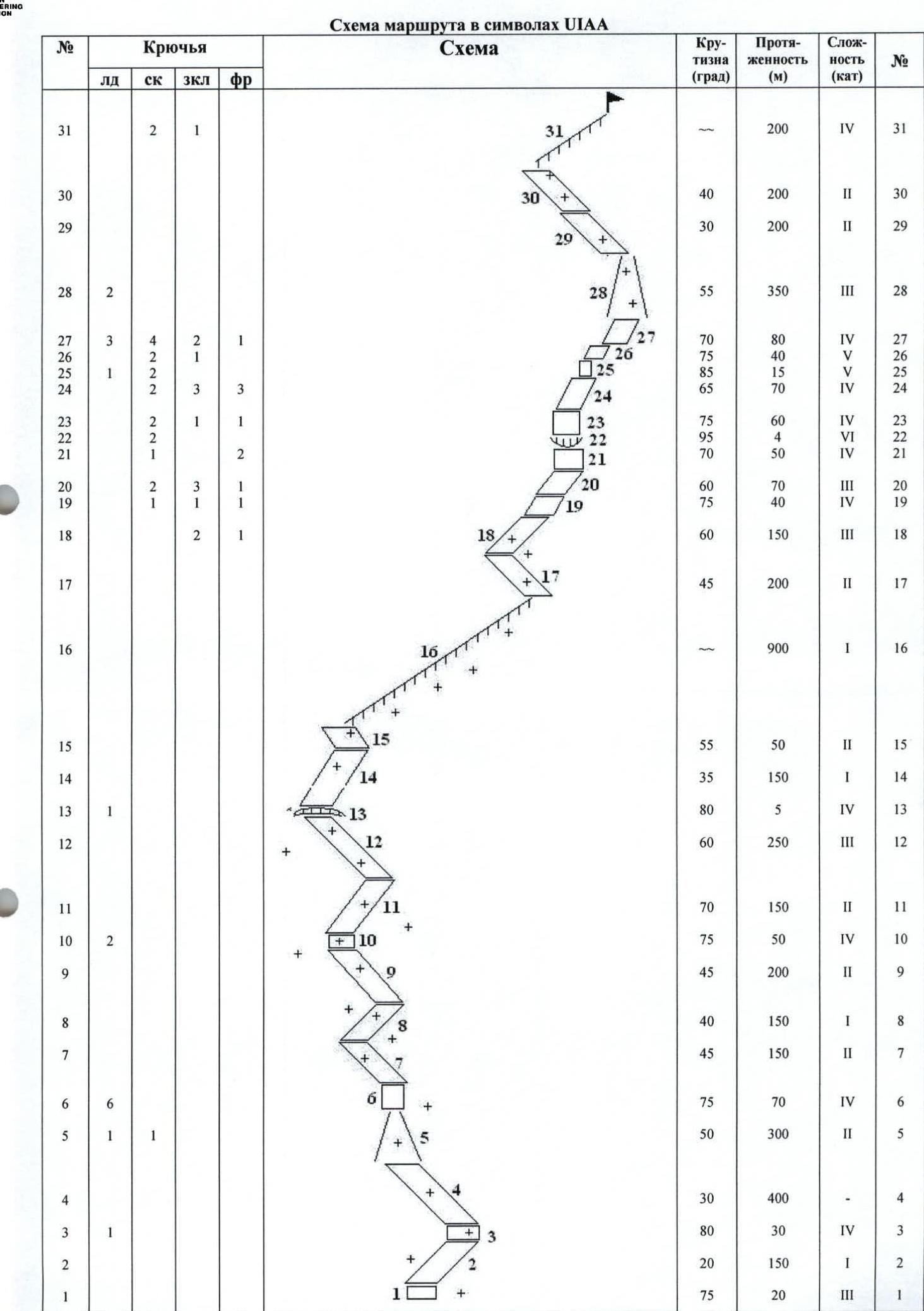
Photo report on the route
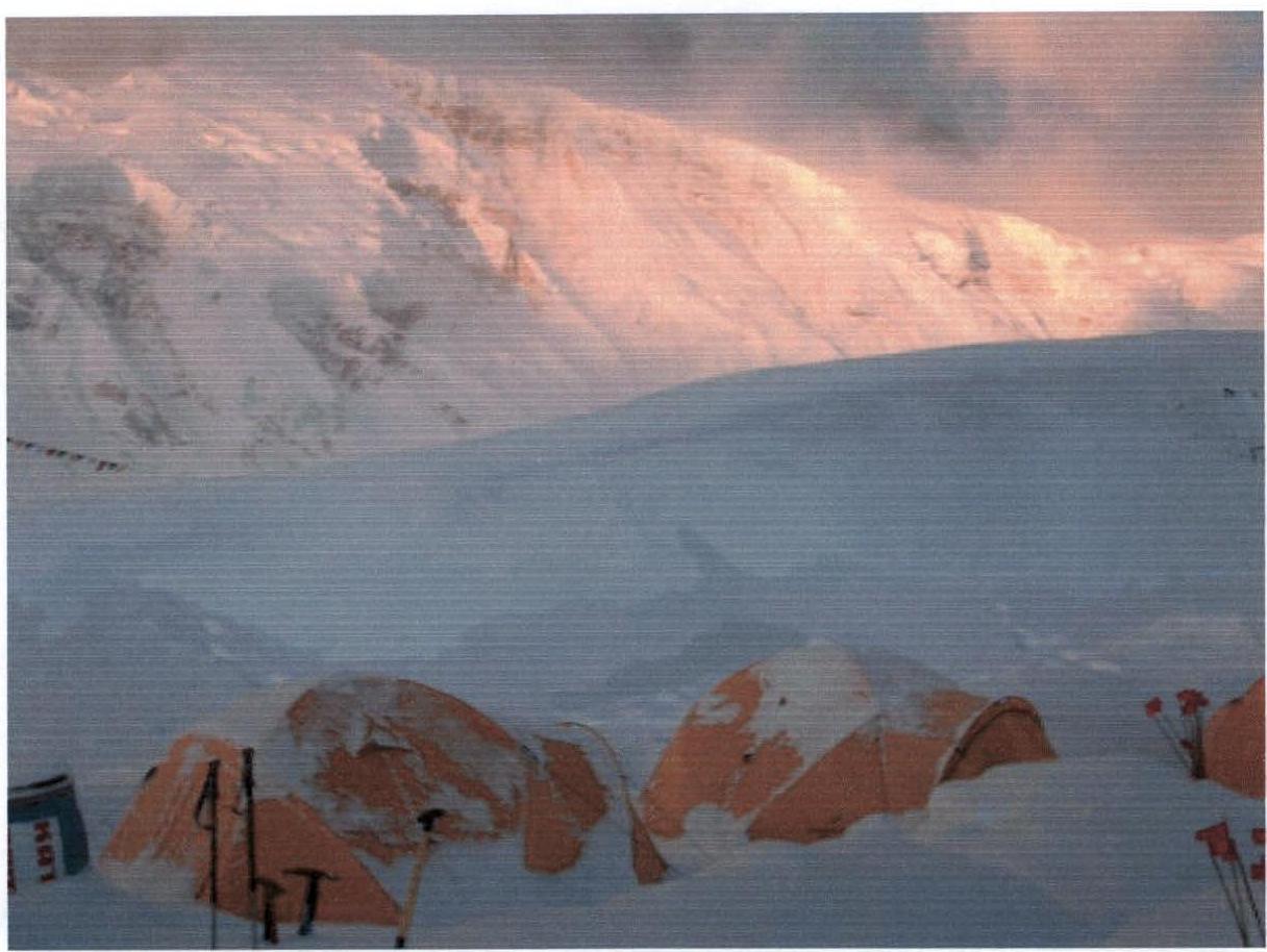
Base Camp of the expedition at an altitude of 4700 m. The summit of Manaslu is in the background.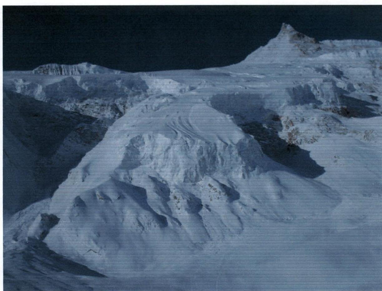
Lower part of the wall from its foot at an altitude of 5100 m.
Ascent along the snow-ice ridge, section R16.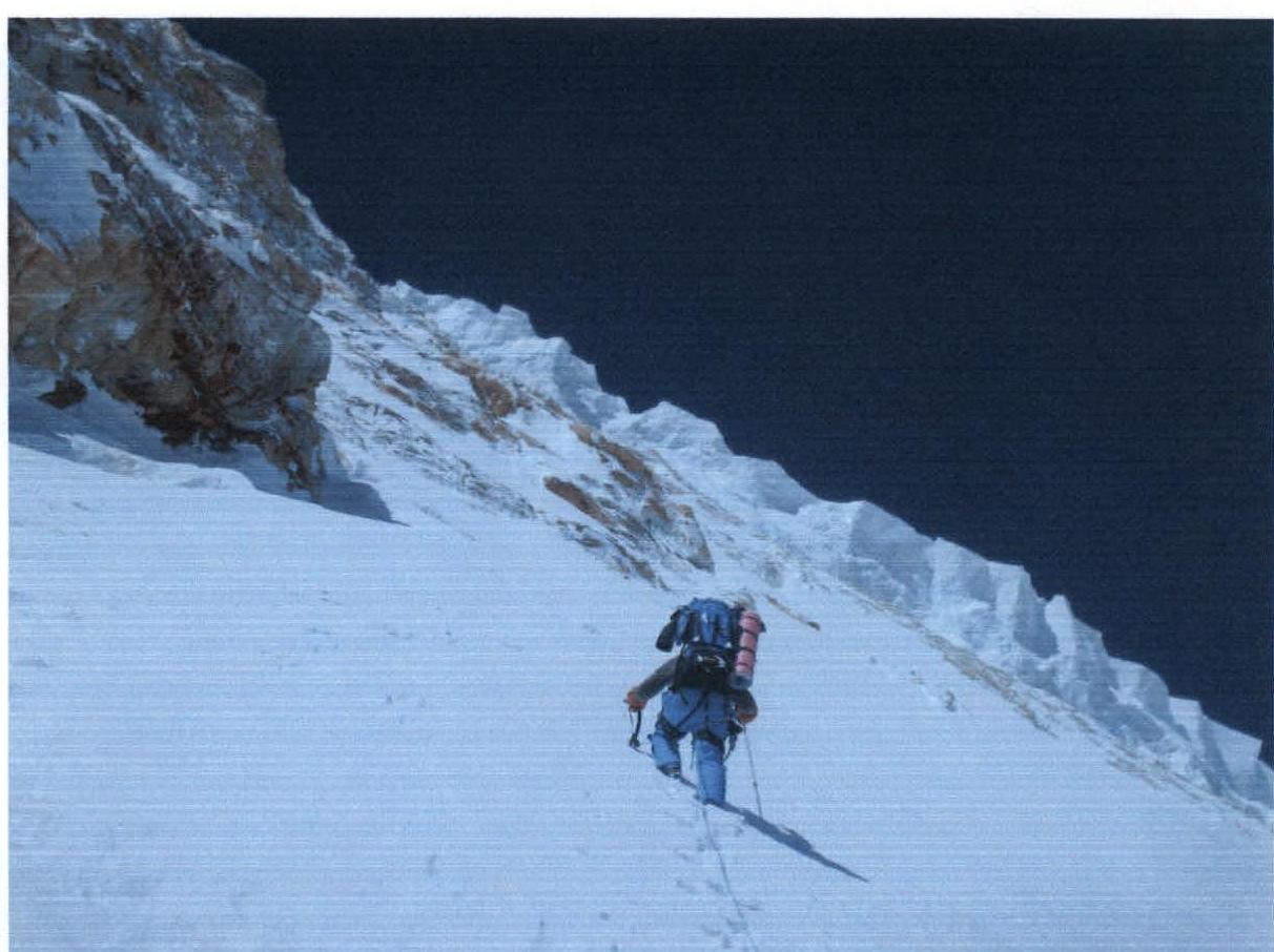
Section R17.
Overnight stay at 7450 m.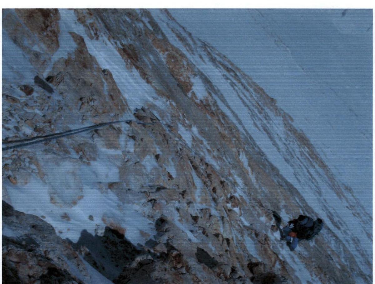
Section R22.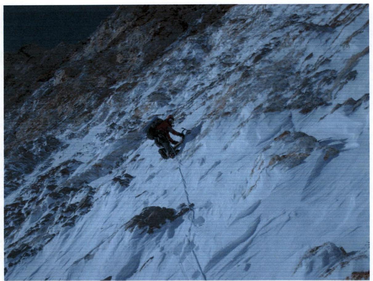
At an altitude of 7600 m, section R23.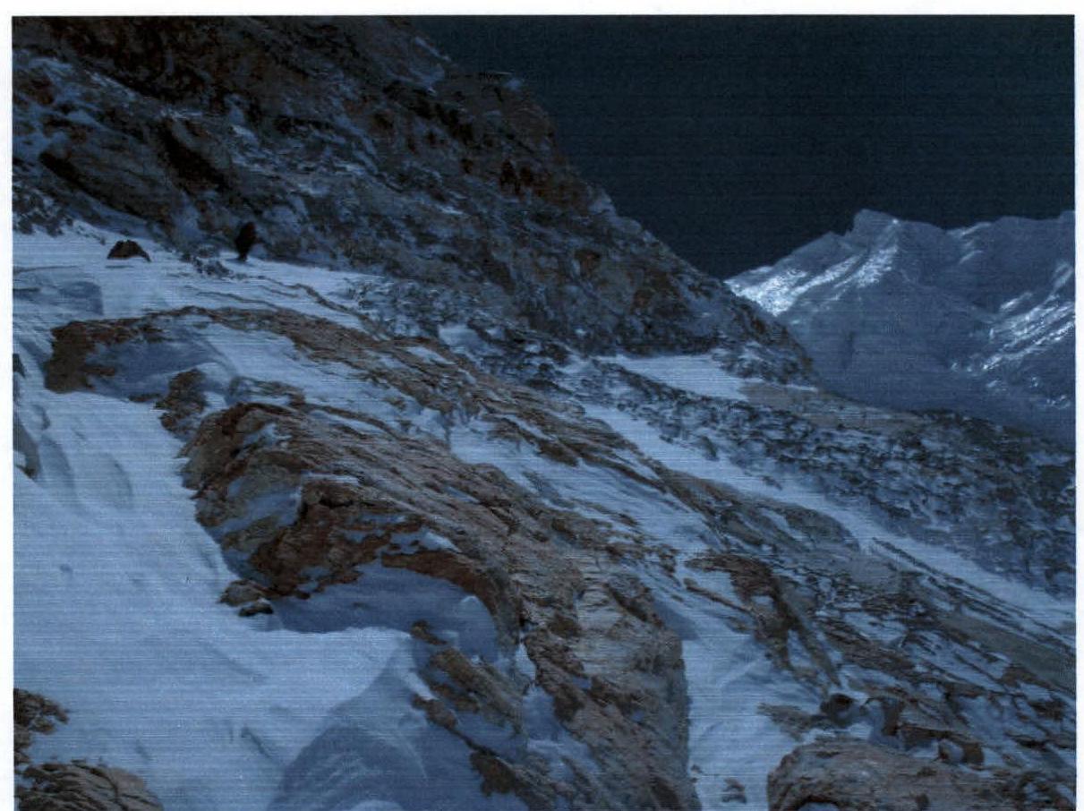
Ahead are sections R26, R27.
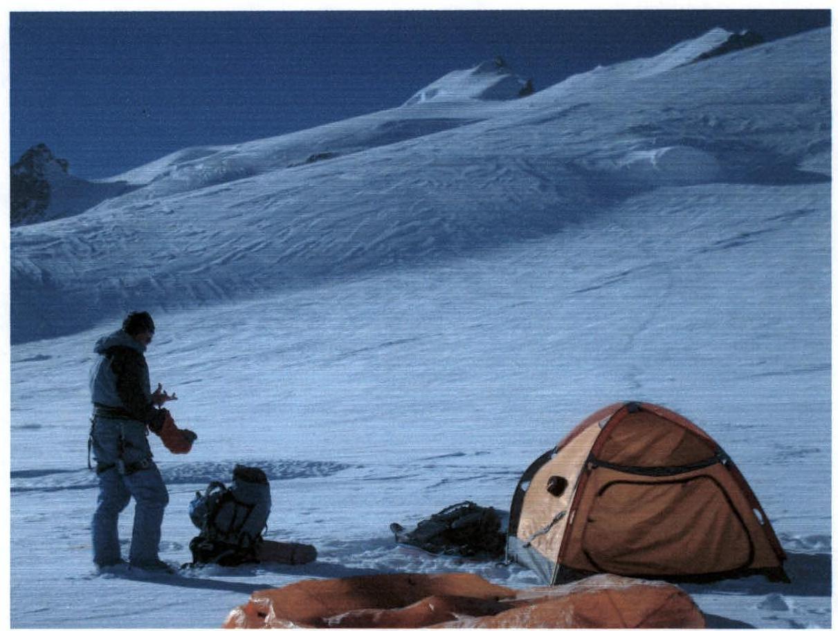
Morning on the plateau (7600 m) after the ascent.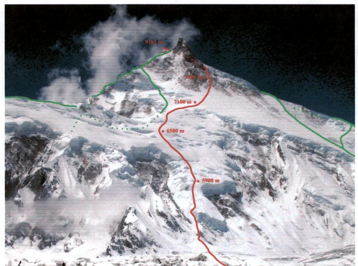
Route along the North-East slope of Manaslu, passed by the team of the Central Sports Club of Kazakhstan
Comments
Sign in to leave a comment