
RUSSIAN ALPINISM CHAMPIONSHIP
in the high-altitude class
REPORT
ON THE ASCENT TO MANASLU PEAK (8163) FROM THE NORTH ("CLASSIC") SNOW-ICE ROUTE, CATEGORY 5A DIFFICULTY, BY THE "FA LENOBLASTI" TEAM FROM SEPTEMBER 23, 2023 TO SEPTEMBER 28, 2023
I. Ascent Passport
| 1. General Information | ||
|---|---|---|
| 1.1 | Full Name, Sports Rank of the Leader | Dusheiko Alexander Sergeevich, 1st sports rank |
| 1.2 | Full Name, Sports Rank of Participants | Kruglov Oleg Sergeevich, 1st sports rank, Cherdantsev Alexey Igorevich, 1st sports rank |
| 1.3 | Full Name of Coach | Dusheiko Alexander Sergeevich, 1st sports rank |
| 1.4 | Organization | RFSOO "Federation of Alpinism of Leningrad Region" |
| 2. Characteristics of the Ascent Object | ||
| 2.1 | Region | 11.1 Himalayas |
| 2.2 | Valley | Manaslu Himal |
| 2.3 | Number of Section According to 2013 Classification Table | 31 |
| 2.4 | Name and Height of the Peak | Manaslu - 8163 m |
| 2.5 | Geographic Coordinates of the Peak (Latitude/Longitude), GPS Coordinates | 28°33′00″ N 84°33′35″ E |
| 3. Characteristics of the Route | ||
| 3.1 | Name of the Route | from the north ("classic") |
| 3.2 | Proposed Category of Difficulty | 5A |
| 3.3 | Degree of Route Exploration | - |
| 3.4 | Nature of the Route Terrain | snow-ice |
| 3.5 | Height Difference of the Route (altimeter or GPS data indicated) | 3263 |
| 3.6 | Length of the Route (in meters) | 9850 m on the map (navigator 12,000 m) |
| 3.7 | Technical Elements of the Route (total length of sections of various difficulty categories with indication of terrain type (snow-ice, rocky)) | 2nd cat. diff. rocks - 30 m. 4th cat. diff. ice - 150 m. 5th cat. diff. ice - 40 m. 6th cat. diff. ice - 5 m. |
| 3.8 | Average Steepness of the Route, ° | 30° |
| 3.9 | Average Steepness of the Main Part of the Route, ° | 25° |
| 3.10 | Descent from the Summit | Via 5A cat. diff. on the ascent route |
| 3.11 | Additional Characteristics of the Route | Water (snow) available. |
| 4. Characteristics of Team Actions | ||
| 4.1 | Time of Movement (team's walking hours, in hours and days) | 28 hours, 5 days |
| 4.2 | Camp Sites | C1, C2, C3, C4. All convenient, in a tent |
| 4.3 | Time of Route Preparation | - |
| 4.4 | Departure onto the Route | 8:30 September 23, 2023 |
| 4.5 | Arrival at the Summit | 14:39 September 28, 2023 |
| 4.6 | Return to Base Camp | 19:45 September 29, 2022 |
| 5. Characteristics of Weather Conditions | ||
| 5.1 | Temperature, °C | −22 °C (felt like −28 °C at night) |
| 5.2 | Wind Speed, m/s | 12 m/s on the day of the assault |
| 5.3 | Precipitation | About 20 cm of snow |
| 5.4 | Visibility, m | normal |
| 6. Person Responsible for the Report | ||
| 6.1 | Full Name, e-mail | Dusheiko Alexander Sergeevich, info@alp-school.com |
II. Description of the Ascent
1. Characteristics of the Ascent Object
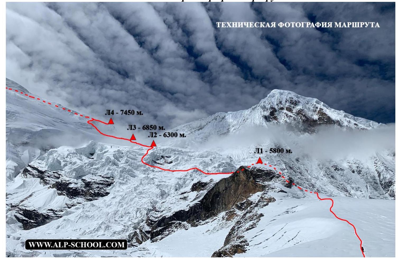
PEAK — 8167 m. General photo of the peak.
- C1 — 5800 m.
- C2 — 6300 m.
- C3 — 6850 m.
- C4 — 7450 m.

Map of the geographical location of the area. We travel to the Darapani area by car, and from there, 3 days of trekking to BC (4900 m). Distance 51 km.
2. Characteristics of the Route
Technical photograph of the route C1–C4
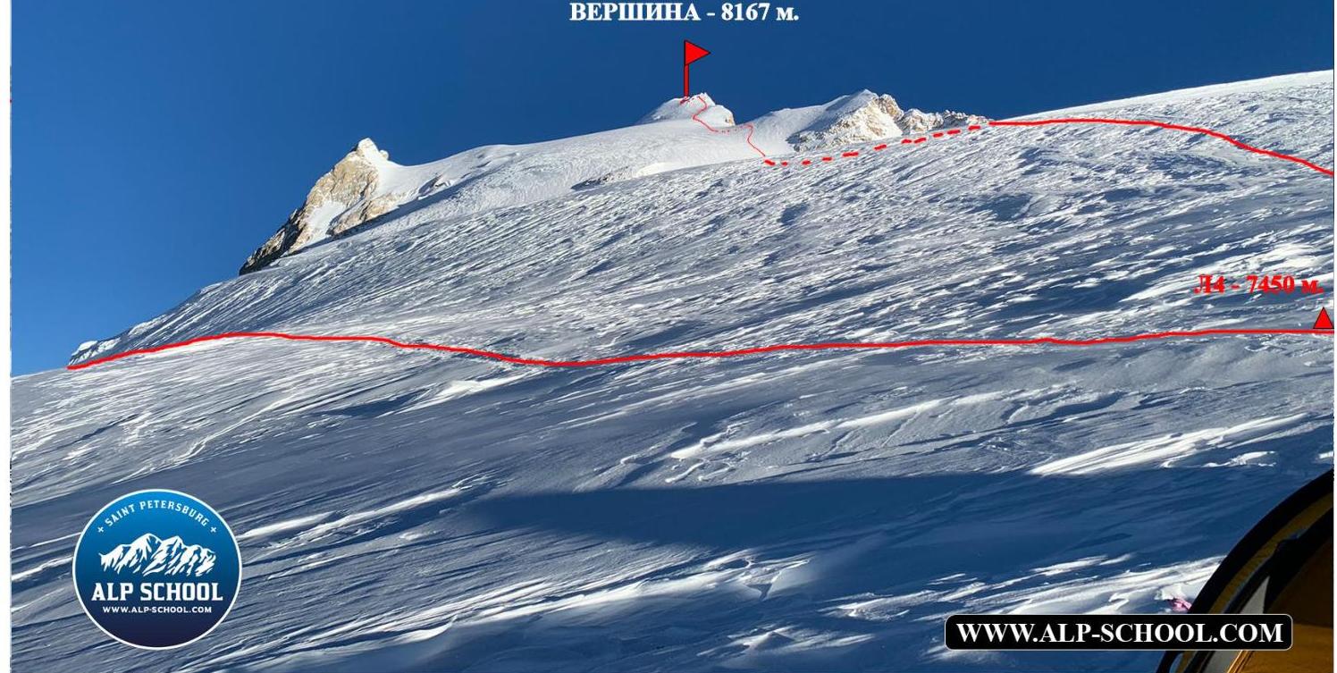
Technical photograph of the route C4–Summit. Technical photograph of the route: Summit — 8167 m.
3. Characteristics of Team Actions
| Section # | Description | Photo # |
|---|---|---|
| BC–C1 | About 20 minutes of walking on a beaten path and ascent on easy rocks of 2nd category difficulty about 30 m, then approach to the glacier on "goat tracks" about 10 minutes and exit onto the closed glacier, movement on which is strictly in rope teams and organization of variable belays in some places to overcome bergschrunds and seracs. Total time 3 hours 30 minutes. | |
| C1–C2 | We enter the icefall via a cornice from the left side and, moving between seracs, gradually traverse left and at the very end climb a 5-7 m ice wall, breaking through a small cornice. As practice showed, it could have been bypassed 30 m to the right, but who knew… | Photo # 2, 3, 4 |
| C2–C3 | On the closed glacier, navigating through seracs, we approach a large ice wall about 15 m high and bypass it by traversing left on snow with an angle of 40°, the ascent onto the bergschrund on snow is about 60°, 30 m. | Photo # 5 |
| C3–C4 | Crossing the closed glacier under the couloir from the right side and passage onto the icefall between the breaks in the glacier with exit onto the ice plateau above 7200 m. | Photo # 6, 7 |
| C4–Summit | We ascend on snow-ice fields towards the main summit, bypassing the eastern summit of Manaslu (7992 m) on the right, and exit onto the main ridge. We traverse it from the right side, bypassing the false summit on the right and descending on snow below the rocky angle to avoid climbing rocks and simply bypass the difficult section, albeit covered with convenient snow, and enter a small couloir (an inclined inner angle) that leads directly to the true summit, adorned with various debris. After ascending to the summit, we return to C4 via the ascent route. Descent took about 2 hours 30 minutes. | Photo # 8 and Technical photograph of the route "C4–Summit" |
| C4–BC | We assemble our gear unhurriedly after sunrise. A slight wind of about 50 km/h affected our packing. On the descent, we collected gear left by us and our "friends" (after rescue works): excess food and trash. We descended to BC only by 19:00. |
Photo # 1
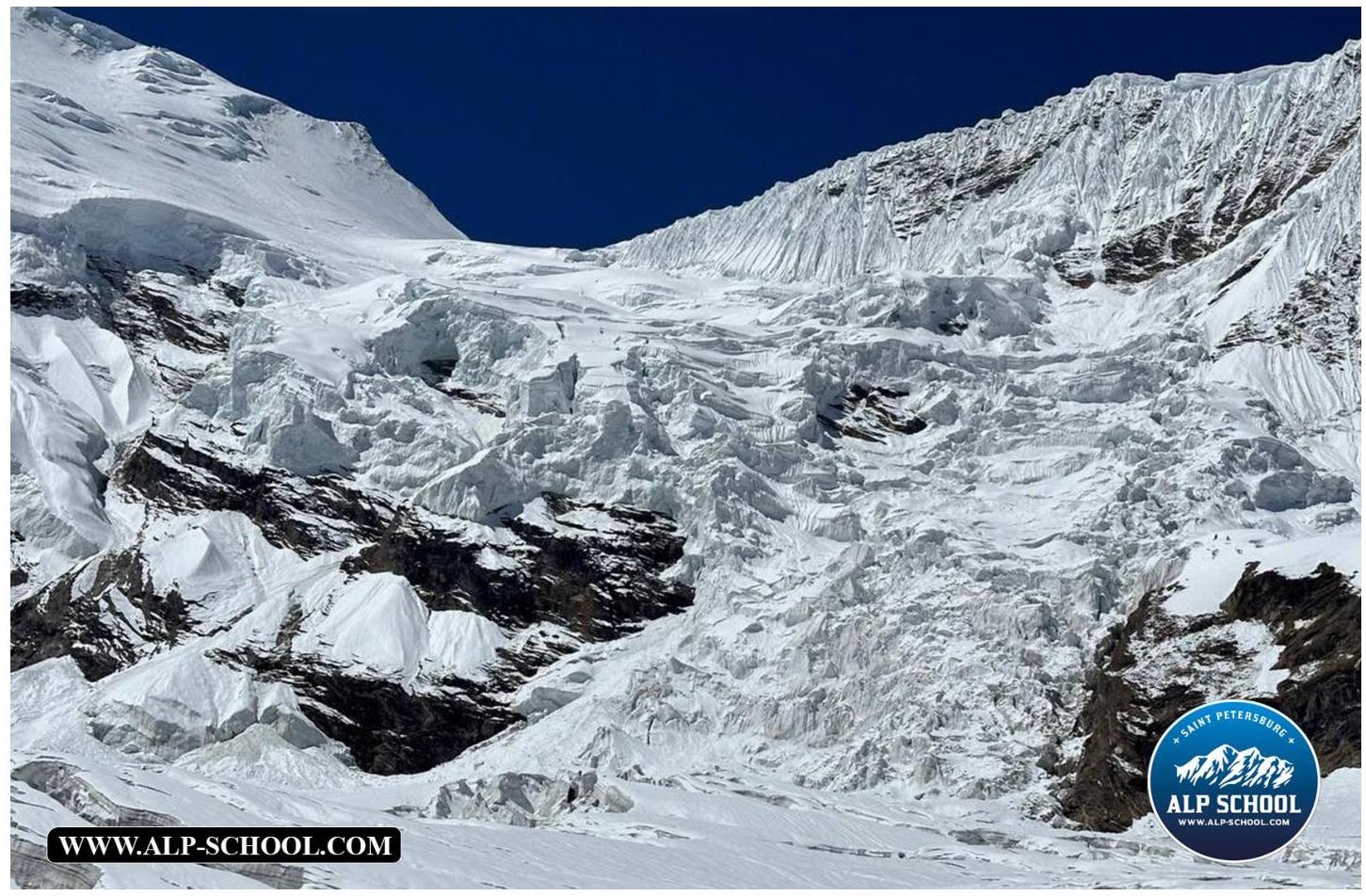
Photo # 2
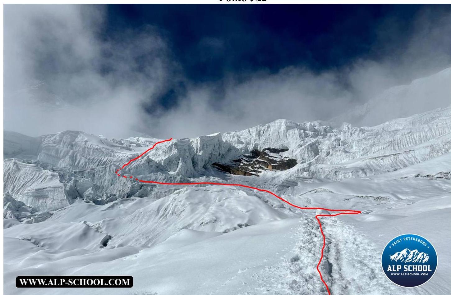
Photo # 3
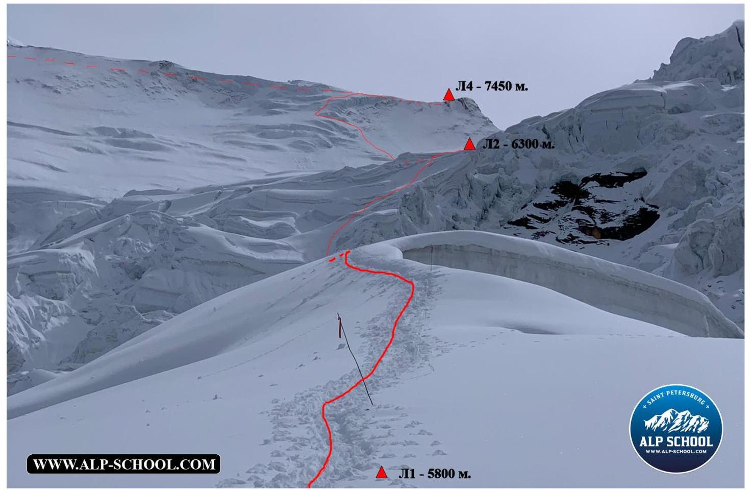
Photo # 4
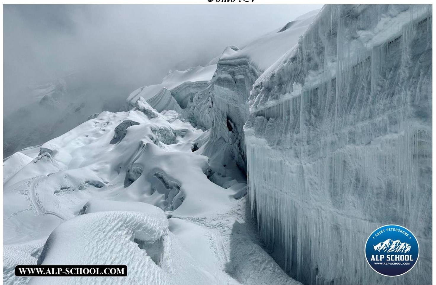
Photo # 5
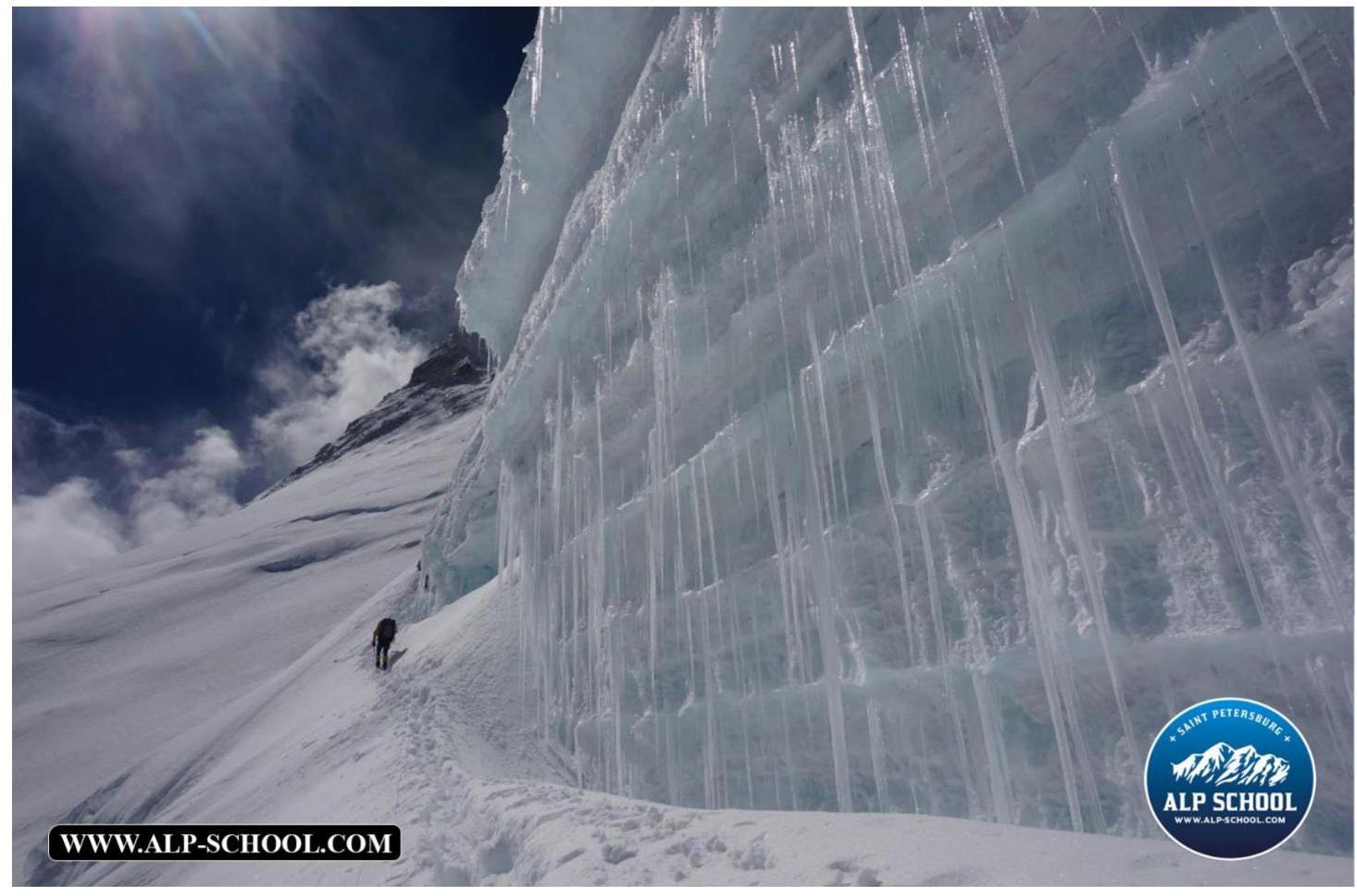
Photo # 6
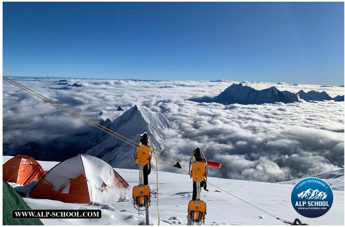
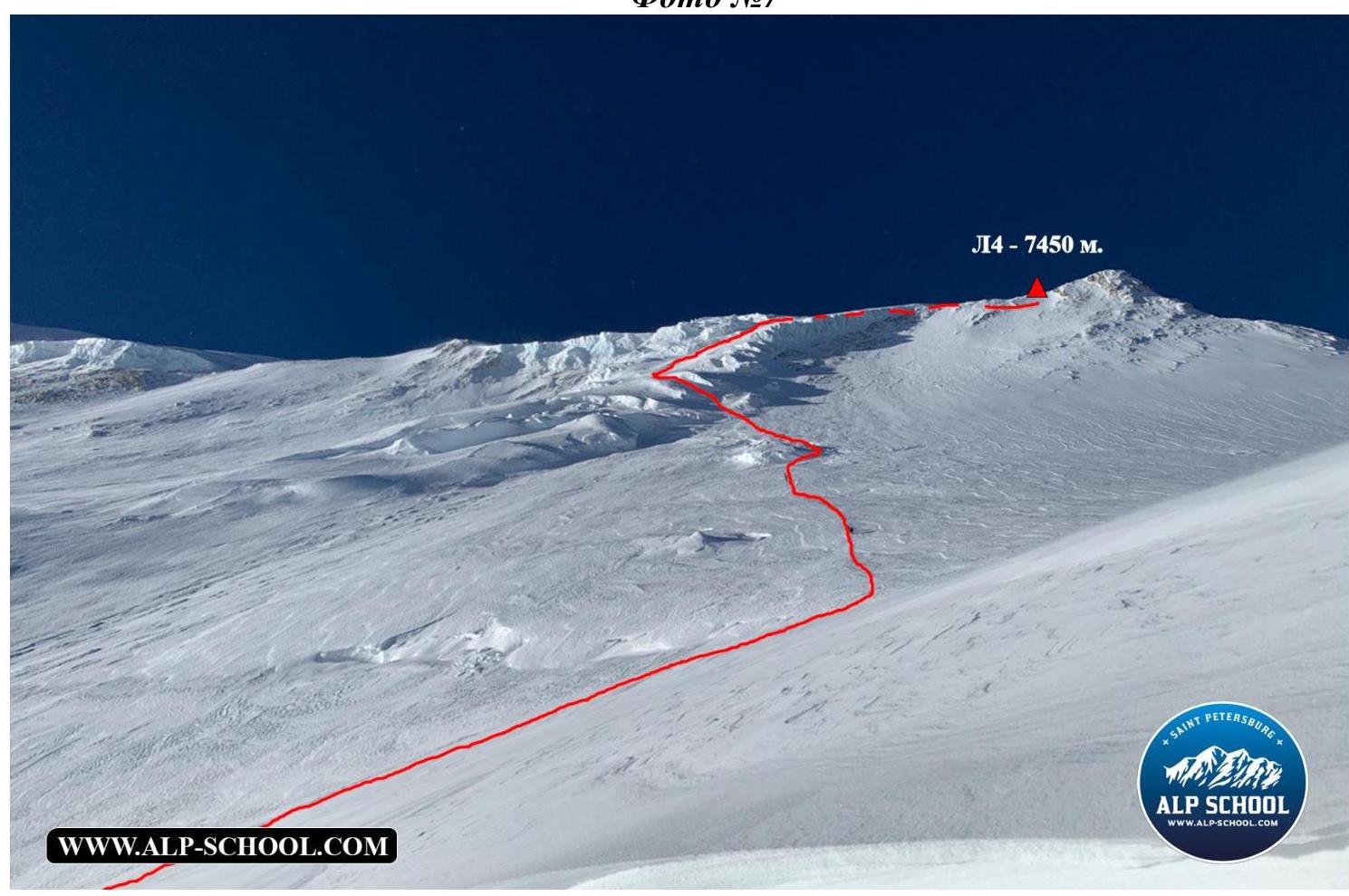
Photo # 8 (team photo at the summit)

Tactics and Team Actions on the Route
September 22, 2023 (day 0) — overnight stay at 4900 m (BC) The group approaches the route above the standard BC (4900 m), where a cache was previously established during acclimatization. Early bedtime.
September 23, 2023 (day 1) — overnight stay at 5800 m (C1)
Early rise, departure onto the route at 6:00 to traverse the glacier (very hot). Ascent above C1 (5800 m): at 9:30, we decided not to ascend further and set up camp.
September 24, 2023 (day 2) — overnight stay at 6300 m (C2)
In 3 hours, we ascended to 6300 m (approximately, the group's speed was 36 minutes per 100 m of ascent). We ascended above the classic C2, decided not to rush and not "jump" over camps. And the decision was correct.
September 25, 2023 (day 3) — overnight stay at 6850 m (C3)
We ascended above the standard C3 (6600 m) by 250 m, where the third camp was previously located, which significantly reduced the time of transition and the strength of participants to the fourth camp the next day.
September 26, 2023 (day 4) — overnight stay at 7450 m (C4)
Due to strong winds and participation in rescue works, we were able to ascend to the fourth camp only by evening. We gathered gear for the assault.
September 27, 2023 (day 6) — overnight stay at 7450 m (C4)
Due to general fatigue and late ascent to the fourth camp, we decided to postpone the nighttime departure to the next day.
September 28, 2023 (day 5) — assault and overnight stay at 7450 m (C4)
We planned to depart for the assault at approximately 1:00, but due to weather conditions, we departed at 3:15.
September 29, 2023 (day 6) — overnight stay at 4900 m (BC)
In the morning, we exited the fourth camp and descended to BC by 19:00.
The ascent was accomplished without the use of oxygen, without the assistance of high-altitude guides and porters, and without the establishment of intermediate camps. Belaying on the route during the ascent was carried out using our own equipment.
Conclusions
If there is no wind, then up to the third camp (6850 m), it is necessary to walk in just a T-shirt and bring much more liquids. Ideally, movement between camps should be done early in the morning.
Route Safety Assessment
The route is generally safe. The most hazardous areas are at its beginning. Therefore, an early departure of groups onto the route is recommended. The thawing of the "starting" part of the route is a cause for concern. With fresh snow, there is a high probability of avalanches above the third camp (6850 m).
There are many convenient places for overnight stays on the slope. One should not give in to the desire to ascend faster: if the weather permits, it is better to move unhurriedly through all camps.
Radio communication along the route is stable up to the very summit (8163 m). Water in the form of snow is available throughout the entire route.
4. Characteristics of Weather Conditions
17:32 4 WhatsApp 0. Manaslu Elevations:

If you need additional materials: videos, photos, or consultation — feel free to write to us: https://vk.com/alp_school_spb ↗
Comments
Sign in to leave a comment