
ASCENT LOG
- Mountain system — Himalayas
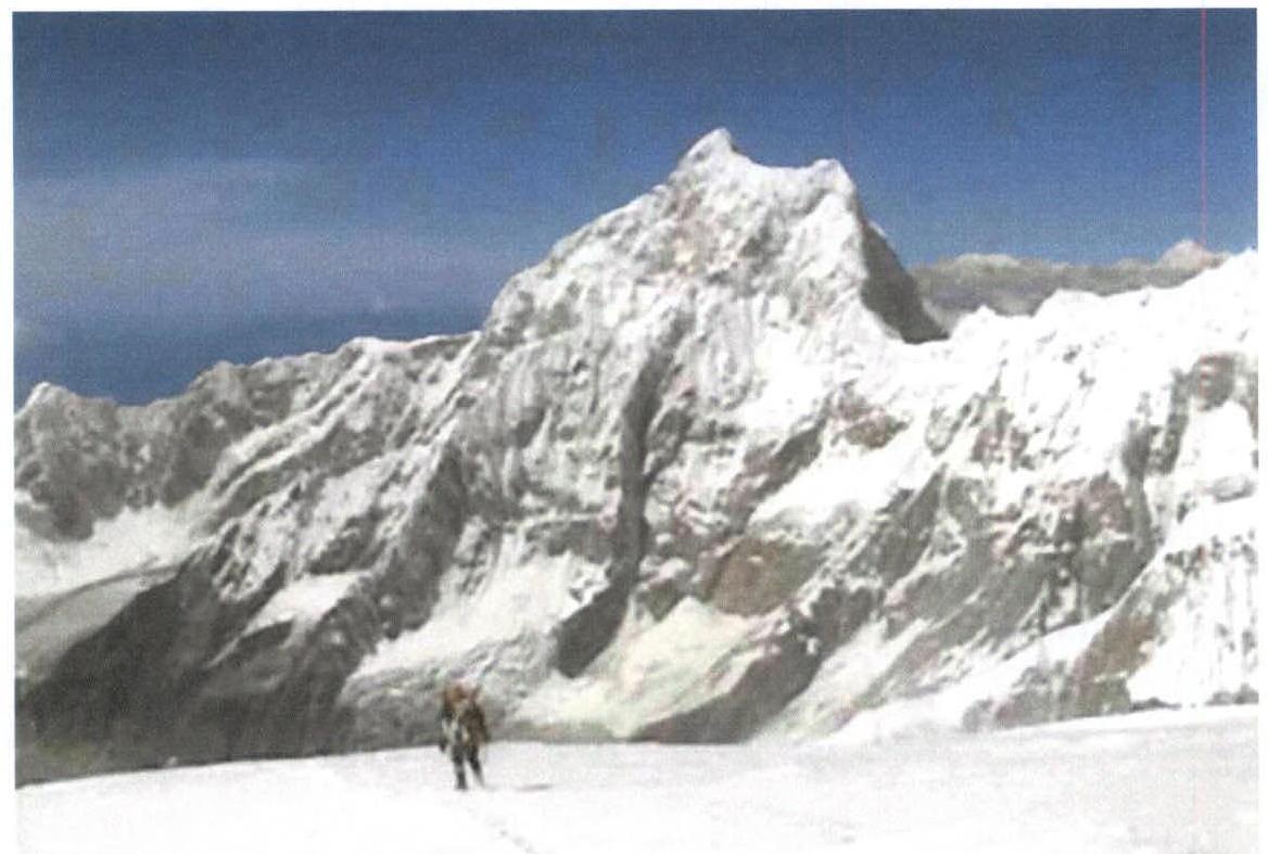
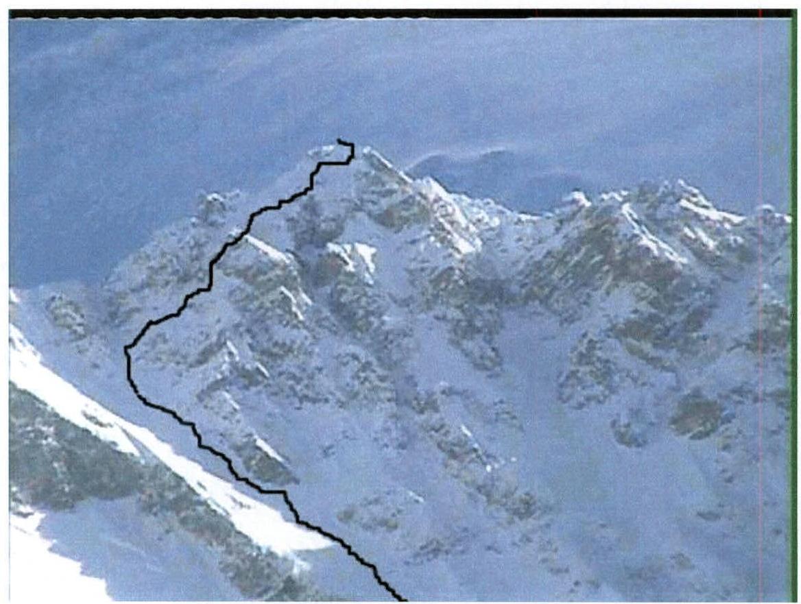
- Kangchenjunga peak, 8586 m, Southwest slope from Yalung Glacier.
- Category of complexity — 6A approximately
- Character — combined
- Route length — 16723 m
Length of sections V–VI cat. difficulty — 3 m
- Height difference of the route — 2986 m
- Pitons used: total — 42
left on the route — 12
| Si | Sk | Ld | Zakl. Elem |
|---|---|---|---|
| 22 | 8 | 12 | 0 |
| 0 | 0 | 0 | 0 |
- Man-hours of the team on the route: 126
- Leader: Denis Urubko — MS
Team members:
- Vasily Pivtsov — MS
- Alexey Raspopov — CMS
- Maksut Zhumaev — CMS
- Sergey Lavrov — HMS
- Sergey Brodsky — CMS
- Damir Molgachev — CMS
- Coach Ilyinsky Yervand Tikhonovich — HMS
- Start of work on the route: April 20, 2002.
Ascent start: May 10, 2002.
Summit: May 13, 2002.
Descent to Base Camp: May 15, 2002.
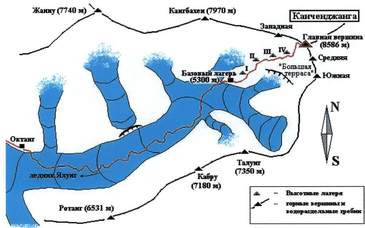
 Map of the ascent area
Ascent graph
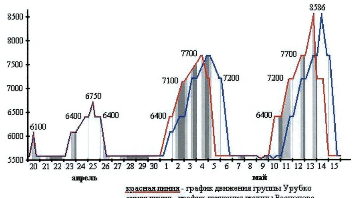
red line — graph of Urubko group's movement, blue line — graph of Raspopov group's movement
- — good weather
- — cloudy, light snow
- — snow
Group equipment
| № | Name | Quantity | Weight 1 pc (kg) | Weight (kg) |
|---|---|---|---|---|
| 1 | High-altitude tent | 7 | 4.5 | 31.5 |
| 2 | Stove | 1 | 1.3 | 1.3 |
| 3 | Gas burner | 3 | 0.3 | 0.9 |
| 4 | Kitchen (dishes etc.) | 3 sets | 1 | 3 |
| 5 | Main rope 50 m — 10 mm | 4 | 3 | 12 |
| 6 | Auxiliary rope 100 m — 9 mm | 8 | 4 | 32 |
| 7 | Repschnur 50 m — 6 mm | 3 | 1.5 | 4.5 |
| 8 | Snow hooks | 25 | 0.25 | 5 |
| 9 | Rock pitons | 25 | 0.04 | 1 |
| 10 | Ice hooks | 25 | 0.06 | 1.5 |
| 11 | Carabiners | 25 | 0.06 | 1.5 |
| 12 | Radio stations | 3 | 0.5 | 1.5 |
| 13 | Spare power for radio | 3 | 0.3 | 0.9 |
| 14 | Snow shovel | 2 | 0.5 | 1 |
| 15 | First aid kit | 2 | 0.5 | 1 |
Total weight of equipment — 98.6 kg
Description of the ascent area
Kangchenjunga (translated from Nepali — "Five Treasures of the Great Snow") is the third highest peak in the world. Located in the eastern part of the Himalayan range, it is a broad mountain massif with four peaks, stretching from northwest to southeast. Politically, it is located on the border between Nepal and India.
The Himalayan mountain system, being the highest on the planet, stretches in a latitudinal direction between the Indian subcontinent and the Tibetan Plateau. It was formed as a result of the compression of continental platforms — Eurasian and Indian. Tectonic processes continue to this day, causing the uplift of the mountain range.
Meteorological conditions here are formed by the opposition of two zones of high atmospheric pressure, which arise with an annual periodicity:
- In summer, the "summer" monsoon prevails, bringing moisture from the Indian Ocean.
- In winter, the monsoon born on the Tibetan Plateau dominates — dry and cold, practically not giving snow and rain.
Heavy summer precipitation, caused by the location of the Himalayas on the border of two climatic zones, led to a powerful glaciation of the mountains. The Kangchenjunga area is closest to the ocean and, therefore, is most exposed to its humid air masses. The large size and speed of glaciers characterize this very clearly, and the inconstant meteorological conditions often create problems for mountaineers.
Kangchenjunga is not part of the watershed of the Himalayan range and rises somewhat isolated.
- The northern slope is a steep wall, descending in steps by 2500 m. The lower terrace gives rise to giant ice avalanches, descending to the foot along the entire width of the wall. On the left, it is bounded by a steep ridge, which descends with a pair of almost vertical bastions to a wide saddle. To the right, the West summit of Kangchenjunga and the Kangbachen ridge (7902 m) overhang it.
- The southwest facade is also intersected by a terrace at an altitude of 7100 m, where powerful glaciation accumulates, but is generally characterized as more gentle than from the north.
- The southern slope is a virtually uniform snow-ice slope with many chaotically scattered seracs and hanging glaciers.
- From the east, Kangchenjunga looks like a huge ice massif covered with deep snow, with rocks protruding in some places. Two ridges — from the Main summit and from the South summit — stretch almost parallel to the east and are crowned with giant cornices.
Preparation for the ascent
For many years, the National Team of the Republic of Kazakhstan has been working with an orientation towards high-altitude and high-technical ascents. Under the program of 14 peaks above 8000 m, several peaks were conquered in the Himalayas and Karakoram with the current composition:
- Everest,
- Lhotse,
- Hidden,
- Gasherbrum.
In 2000, team members made a passage through the center of the North wall of Khan-Tengri, and many technical ascents were made. Participation in the CIS and Kazakhstan championships, where the team and its athletes took prize places, confirmed the high level of physical and technical training.
Participants' training in the city was conducted year-round at the sports base of the CSKA MO RK and in the Tuyuksu gorge with ascents to peaks up to 4500 m. The senior coach of the team had experience in conducting long-term high-altitude expeditions both in the CIS and abroad. The USSR team in 1989, during the traverse of Kangchenjunga, was represented by seven athletes from Kazakhstan, who received the necessary consultations during the preparation period 2000–2001. Literary sources were also studied, giving a complete impression of the forthcoming route. Based on this, the tactics and equipment for the expedition were selected.
The easiest way to approach the Kangchenjunga peak is from Nepal. From Kathmandu, where all expeditions arrive by air, you can get to Taplejung:
- by local airlines,
- or by road by car (about 20 hours drive).
Our expedition used the second path and arrived in the village of Medibung (near Taplejung), from where, with a caravan of porters (about 100 people), through the village of Yampfudin, we reached Base Camp in 10 days. This place is called "Pasha's grave" at the burial site of a participant in one of the first attempts to conquer Kangchenjunga and is located at an altitude of about 5600 m at the top of a high hill, dividing several tributaries of the Yalung Glacier at the foot of the Southwest slope of the peak.
Ascent execution
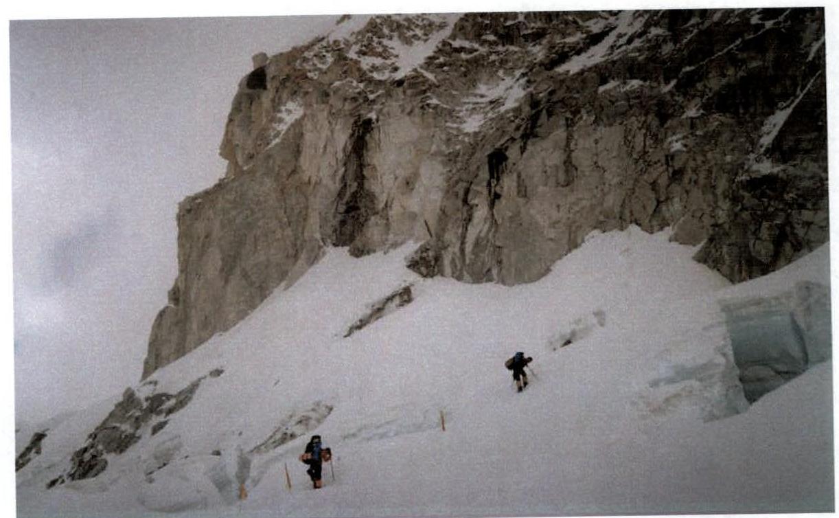
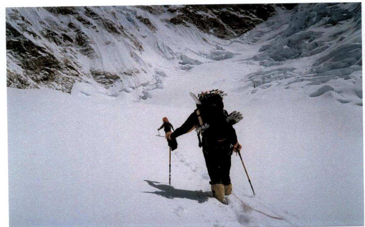
04/19 — Installation of Base Camp (5600 m). 04/20 — Installation of the 1st high-altitude camp (6100 m). The route passes along a wide ridge, which is the edge of the glacier descending from the mountain slope. Ice collapses, seracs. The site was processed by the Korean expedition shortly before our arrival. On the same day, the team descended to the base (7 hours of movement). 04/23 — The team moved along the route, reached camp 1, where they spent the night (4 hours). 04/24 — We reached the site of camp 2 at an altitude of 6400 m through deep snow (6 hours). From camp 1, the trail descends along the rocks to the glacier. It is necessary to walk along the body of the glacier almost to the base of the wall of the West summit of Kangchenjunga, and before the icefall, turn right to more calm ice slopes. Camp 2 was given special attention due to its location in an avalanche-prone area, where climbers have died more than once. During the installation, an optimal place was found, and, as it turned out later, it was extremely successful. 04/25 — The team climbed to an altitude of 6750 m for acclimatization, processing the route (steep snow slopes alternate with ice ledges 10–15 m high), and descended to the site of the previous night's stay (4 hours). 04/26 — All seven participants returned to Base Camp (4 hours). 05/01 — According to the tactical plan, the team was divided into two groups: Urubko+Pivtsov+Zhumaev+Brodsky and Raspopov+Lavrov+Molgachev. On this day, the Urubko quartet climbed to camp 2 immediately (6 hours). The Raspopov trio, having set off a little later, reached camp 1. 05/02 — The Urubko group, processing the route (hung about 600 m of rope), climbed to an altitude of 7100 m (8 hours). The conditions were difficult (deep snow, lack of visibility), so the quartet did not reach the planned site of camp 3 and spent the night on the first safe site. Raspopov with his group climbed to camp 2. 05/03 — The Urubko quartet climbed to an altitude of 7200 m, determined the site for the installation of camp 3, and moved further to process the path along the icefall. A successful passage among the seracs was found, about 200 m of rope was hung, and a trail was made to the beginning of a steep slope under the peak. Here, the group was forced to stop for the night at an altitude of about 7500 m (10 hours). Raspopov with Lavrov and Molgachev set up camp 3. 05/04 — The Urubko group climbed a steep snow-firn slope with ice sections to an altitude of 7700 m, where it set up a tent for camp 4. A site was chosen on a protruding ice ledge. Having spent several hours here, the quartet descended to camp 3, and the Raspopov group climbed to camp 4 for the night (6 hours). 05/05 — The next day, both groups descended to Base Camp (4 hours). 05/10 — Assault exit. A day earlier, the Czech and Korean teams started up. The Urubko quartet climbed to camp 2 (4 hours). 05/11 — Urubko with his group reached camp 3, and Raspopov arrived at camp 2 (4 hours). 05/12 — The quartet from camp 3 climbed to camp 4, where they met the Koreans (6 people) and Czechs (3 people). The Raspopov trio reached camp 3 (6 hours). 05/13 — Urubko+Pivtsov+Zhumaev+Brodsky at 01:00 (Kazakhstan time) went on the assault. Almost none of the participants in foreign groups assisted in breaking through the deep snow and hanging ropes. Only one Sherpa from the Korean expedition provided assistance. Therefore, progress was slow. The terrible cold — about −35 °C — interfered. Along the "Ladders", we reached an altitude of about 8400 m, from where the group turned right to the rocks. Here, the use of insurance and lifeline ropes (about 300 m) was required, and at 15:10, Urubko+Pivtsov+Zhumaev+Brodsky were at the summit of the Main Kangchenjunga peak (8586 m). In addition, two Koreans with a Sherpa and one Czech climbed to the summit. The descent to camp 4 took about 3.5 hours. The Raspopov group was here, so Urubko and Pivtsov continued their descent to camp 3, where they arrived at 21:00 (20 hours). 05/14 — The Raspopov group (exit at 01:00) repeated the path of the first quartet and reached the summit at 13:00 (Raspopov+Lavrov+Molgachev). One Czech climbed with them. By evening, the climbers descended to camp 4, where they spent the night. The Urubko group (Brodsky and Zhumaev joined in the morning) was in camp 3 for insurance, but in the evening, when Raspopov's team descended after the assault, the Urubko+Brodsky duo began their descent to Base Camp. This was due to Brodsky's minor frostbite on his feet during the summit assault. At 21:00, the duo reached the base safely (20 hours). 05/15 — All participants descended to Base Camp (8 hours).
Ascent analysis
Pivtsov V. Everything went great, both in terms of organization and execution of the ascent. The relationship within the team was excellent, and we worked for the common success. The equipment was selected correctly.
Lavrov S. I believe that under the circumstances:
- The ascent was accomplished with maximum safety.
- The tactics were developed correctly.
- Interaction with foreign groups was at a good level.
- Radio communication and overall electrical support of the expedition corresponded to the level.
- The personnel of the firm worked well, special thanks to the cook, who managed to provide good food at the base.
- Rest and recovery during breaks between exits were sufficient.
- All participants were focused on work and achieving the goal.
- I thank the Urubko-Pivtsov-Zhumaev-Brodsky group for processing the route and timely installation of the 4th camp.
- On the day of the ascent, the weather conditions were better than expected, and this helped.
Brodsky S. The hard work on laying the path to the 1st camp was done by the Sherpas of the Korean expedition before us, thanks to them. However, it is great that the upper part of the mountain was almost entirely processed by our group. This indicates the high technical and physical condition of the participants.
Molgachev D. A quick ascent made in a long expedition — extensive approaches. The equipment met modern standards, which helped a lot. We worked in harmony, and I would especially like to note the good and confident insurance of each other on the days of the ascents.
Raspopov A. The experience of organizing the Karakoram-2001 expedition helped in conducting the ascent on Kangchenjunga. Therefore, the difficulties with the caravan during the approaches to the mountain were resolved in a businesslike and calm manner. All deliveries to high-altitude camps were made normally, there was no shortage of anything, and no unnecessary work was performed.
Video and photo shooting were done regularly, for which special thanks to:
- Zhumaev Maksut.
Zhumaev M. I believe that the ascent on Kangchenjunga took place in a normal working mode. Properly planned interaction between the two groups and the organization of high-altitude camps allowed for good acclimatization and a high-speed ascent.
Urubko D. The beauty and history of conquering the peak made us approach the ascent with all seriousness. The participants underwent careful selection, training, and medical examination, which undoubtedly affected the successful outcome of the expedition. The ascent took place at a high pace. I am grateful to the members of my group for discipline and full commitment on the route. The weather practically did not affect the work on the mountain. On the day of the assault, the tactical calculation of the Senior coach of the expedition — to move along the ridge along the rocks, sheltering from the wind — was fully justified.
Ilyinsky E. Some shortcomings in tactical preparation, caused by insufficient experience, were more than compensated by the team's efficiency and good relations within the team. The ascent, on the whole, was грамотным, the expedition was successful. I consider the leadership and ascent to be counted.
Recommendations:
- To Brodsky Sergey — more careful monitoring of health at altitude.
- To all participants — improvement of physical and technical training.

1 — 20°, 2400 m, 1; 2 — 60°, 150 m, 3; 3 — 45°, 800 m, 2; 4 — 65°, 150 m, 3; 5 — 80°, 50 m, 4; 6 — 50°, 250 m, 3; 7 — 0°, 200 m, 1; 8 — 65°, 100 m, 3; 9 — 0°, 150 m, 1; 10 — 10°, 200 m, 1; 11 — 50°, 50 m, 2; 12 — 10°, 200 m, 1; 13 — 15°, 1800 m, 1; 14 — 30°, 1300 m, 1; 15 — ∼, 600 m, 2–4; 16 — 15°, 250 m, 1; 17 — 35°, 250 m, 1; 18 — 75°, 50 m, 3; 19 — 35°, 350 m, 1; 20 — 75°, 40 m, 3; 21 — 35°, 400 m, 1; 22 — 75°, 100 m, 3; 23 — 40°, 200 m, 1; 24 — 90°, 3 m, 5; 25 — 35°, 350 m, 1; 26 — 20°, 300 m, 1; 27 — 30°, 400 m, 1; 28 — ∼, 400 m, 3; 29 — 0°, 300 m, 1; 30 — 75°, 30 m, 3; 31 — 20°, 700 m, 1; 32 — 25°, 400 m, 1; 33 — 35°, 600 m, 1; 34 — 50°, 200 m, 2; 35 — 0°, 1; 36 — 30°, 400 m, 1; 37 — 60°, 70 m, 3; 38 — 40°, 150 m, 2; 39 — 40°, 200 m, 2; 40 — 30°, 400 m, 1; 41 — 30°, 300 m, 1; 42 — 60°, 100 m, 2; 43 — 35°, 200 m, 1; 44 — 70°, 60 m, 2; 45 — 25°, 120 m, 1; 46 — 70°, 100 m, 3; 47 — 40°, 200 m, 2; 48 — 75°, 40 m, 3; 49 — 60°, 100 m, 3; 50 — 45°, 100 m, 2; 51 — 0°, 120 m, 2; 52 — 55°, 80 m, 3; 53 — 30°, 60 m, 1
R13–R11 sections
R13–R16 sections
R31 section, altitude about 7500 m, view of Jannu peak (7710 m).
Upper part of the route, R38–R53 sections
Comments
Sign in to leave a comment