Report
on the first ascent to the summit of Kart 2661 m via the route along the left chimney of the left bastion of the Western wall, approximately 5A category of complexity,
for the period from 5.07.2020 to 5.07.2020
I. Ascent Passport
| 1. General Information | ||
|---|---|---|
| 1.1 | Full Name, sports rank of the leader | Syshchikov Anatoliy Gennadievich, Master of Sports |
| 1.2 | Full Name, sports rank of participants | Glazunov Evgeniy Vladimirovich, Master of Sports |
| 1.3 | Full Name of the coach | - |
| 1.4 | Organization | Irkutsk Regional Public Organization Club of Active Recreation and Alpinism "Gory Baikala", project "Nevozmozhno - eto ne navsegda" |
| 2. Characteristics of the Ascent Object | ||
| 2.1 | Region | South-Muya Ridge |
| 2.2 | Stlanikovaya River | Number of the section according to the classification table of 2013 |
| 2.3 | Kart, 2661 m | 9.11 |
| 2.4 | 3. Characteristics of the Route | Route Name |
| 2.5 | Proposed Category of Complexity | 5A |
| Degree of Exploration of the Route | ||
| 3.1 | Relief Characteristics of the Route | Rocky |
| 3.2 | 559.4 m | Length of the route (indicated in m.) |
| 3.3 | Degree of Exploration of the Route | First Ascent |
| 3.4 | Relief Characteristics of the Route | Rocky |
| 3.5 | Height Difference of the Route | 559.4 m |
| 3.6 | Length of the Route (indicated in m.) | 960 m |
| 3.7 | Technical Elements of the Route (total length of sections of different categories of complexity with indication of the relief character (ice-snow, rocky)) | Rocky I cat. sl. — Rocky II cat. sl. — 300 m. Rocky III cat. sl. — 200 m. Rocky IV cat. sl. — 80 m. Rocky V cat. sl. — 245 m. Rocky VI cat. sl. — 125 m. Rocky VI, A2 — 10 m. |
| 3.8 | Descent from the Summit | Along the ridge in the eastern direction and then along the scree slope to the south, to the shoulder of peak Kart. From it, descent along the overgrown slopes into the valley of the Stlanikovaya River. |
| 3.9 | Additional | - |
| Characteristics of the Route | ||
| :--: | :--: | :--: |
| 4. Characteristics of the Team's Actions | ||
| 4.1 | Time of Movement (team's walking hours) | 6.5 hours |
| 4.2 | Overnight Stays | No |
| 4.3 | Time at Control Points | Exit from the base camp under the summit of Kart — 5:00, Start on R0 — 7:00, Summit — 13:30, Return to BC — 16:00 |
| 5. Characteristics of Weather Conditions | ||
| 5 | Clear, no precipitation, temperature approximately +20 °C. | |
| 6. Responsible for the Report | ||
| 6.1 | Full Name, e-mail | Syshchikov Anatoliy Gennadievich, a.syshikov@mail.ru, +7 963 275 60 92 |
II. Description of the Ascent
- Characteristics of the Ascent Object
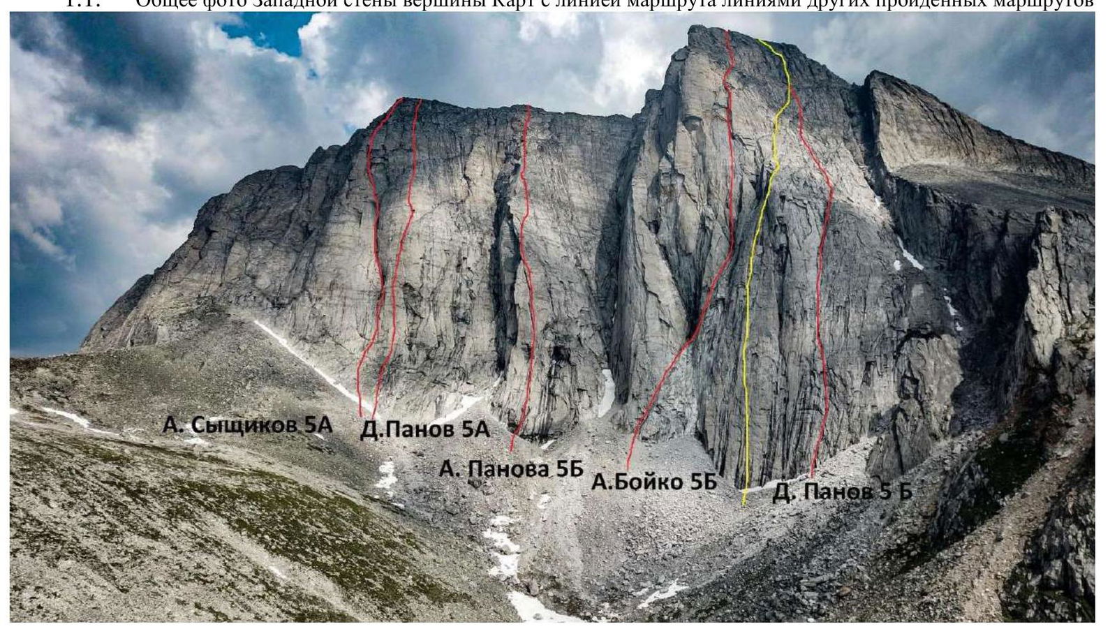
1.1. General photo of the Western wall of the summit Kart with the line of the route, lines of other climbed routes
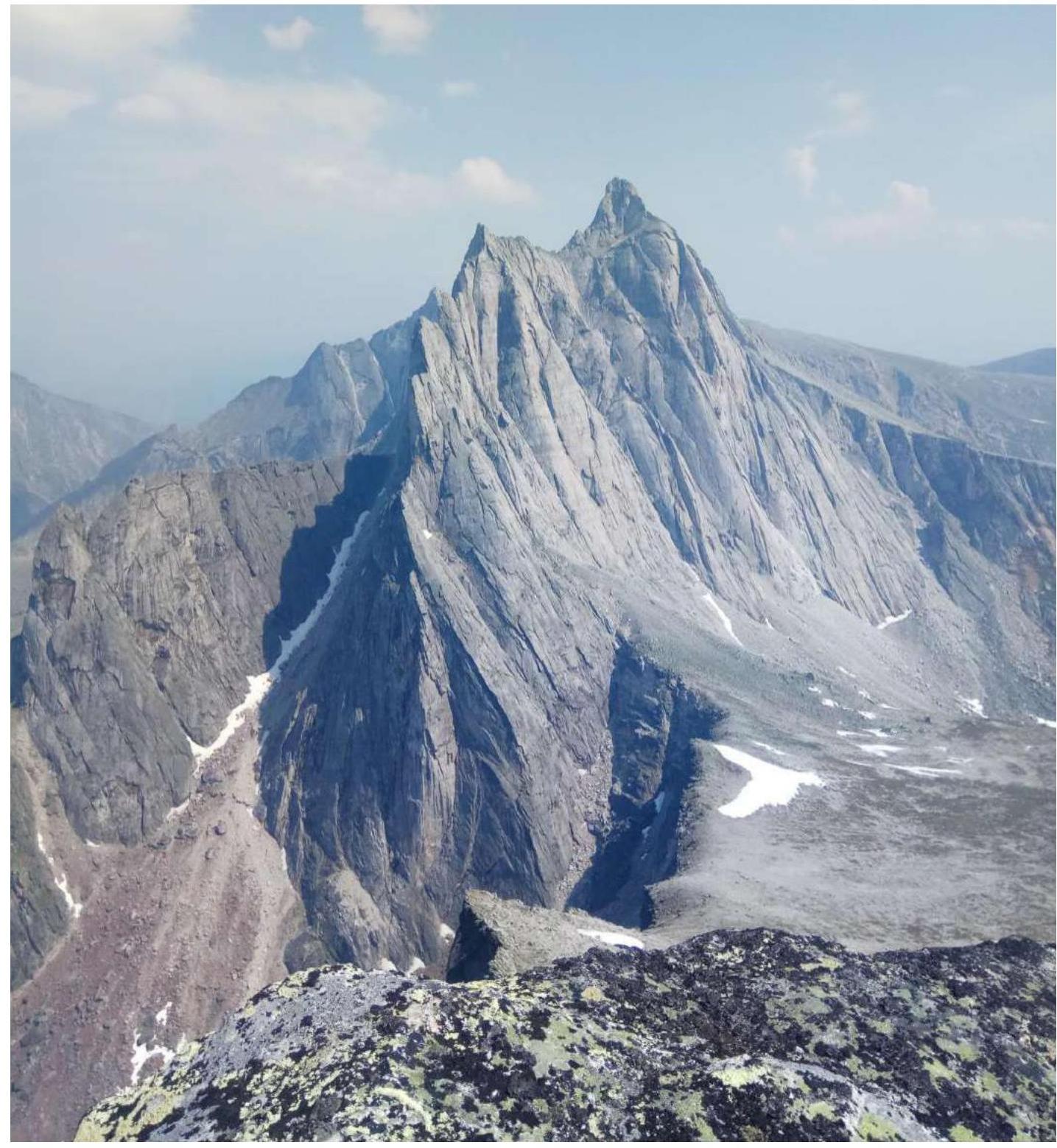
1.2. Photo of the profile of the Western wall of peak Kart
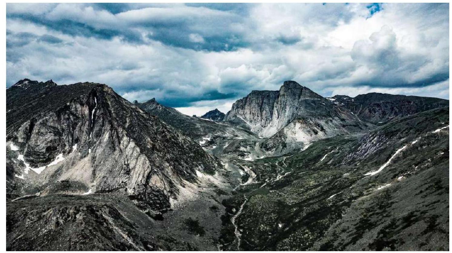
1.3. Photopanorama of the upper reaches of the Stlanikovaya River
1.4. Map of the Area
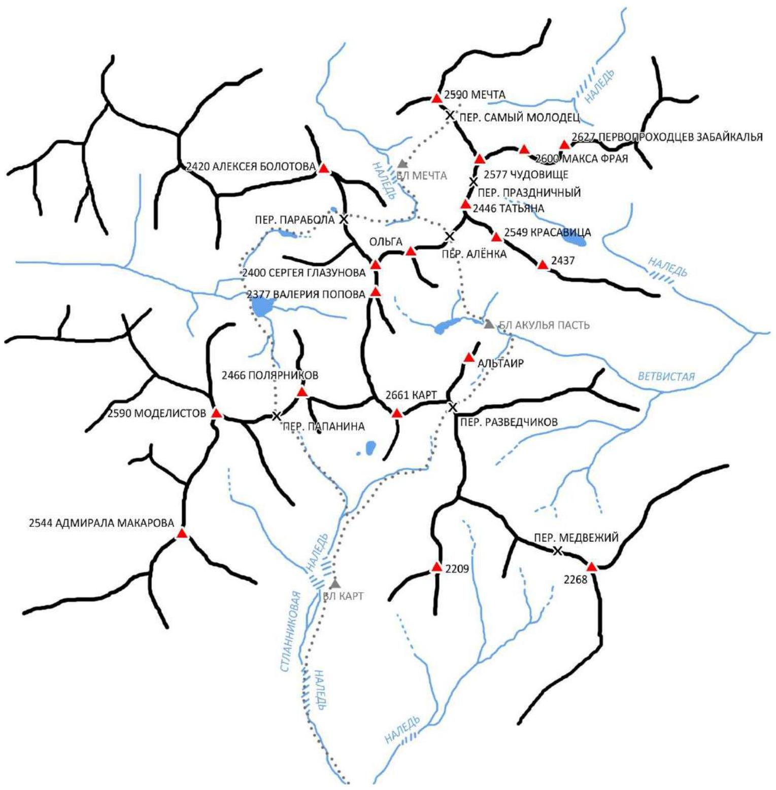 Map
of the area, path of the expedition 2020
g.
Map
of the area, path of the expedition 2020
g.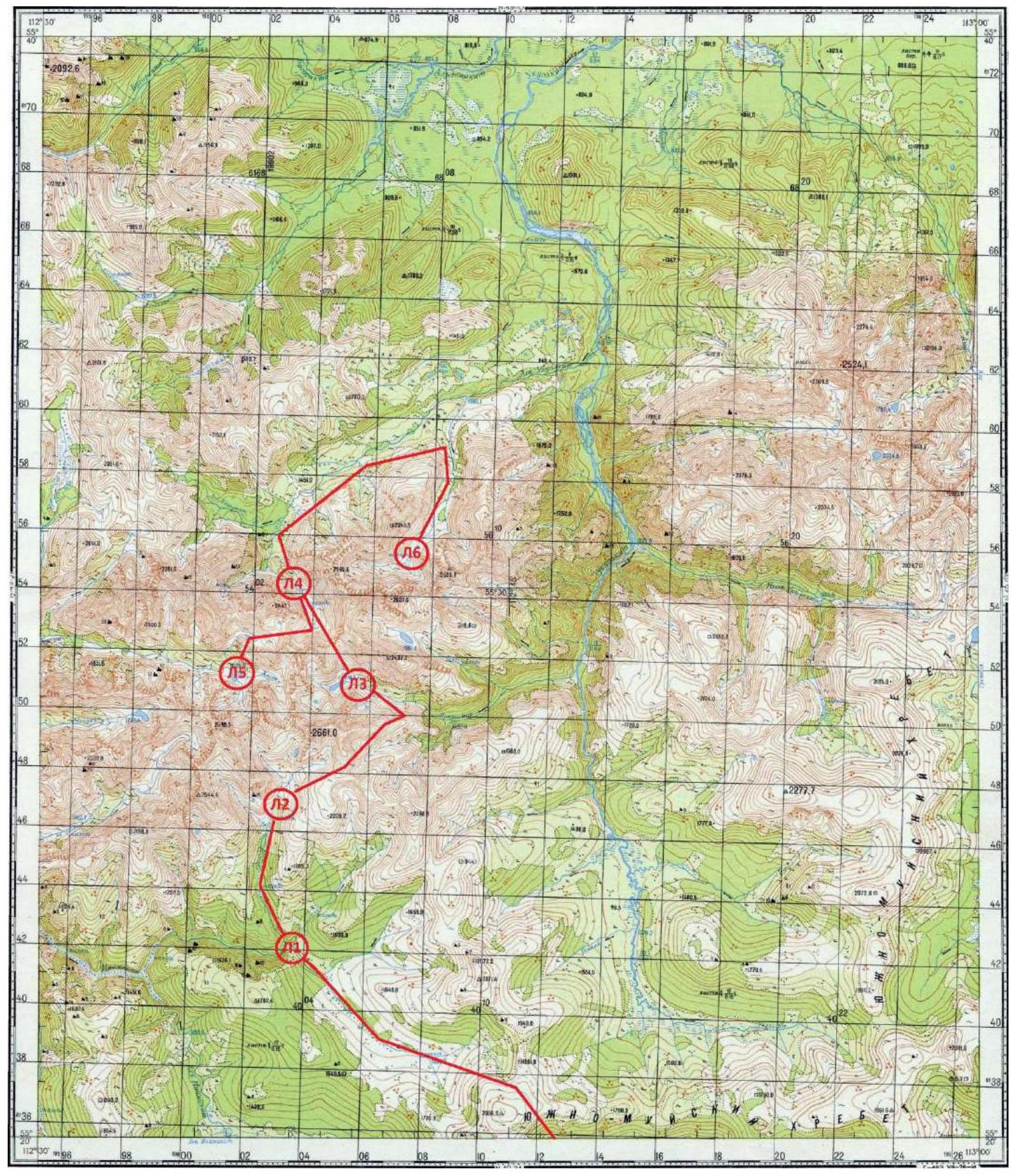 Peak
Kart is located in the southwestern part of the South-Muya Ridge in the upper reaches of the Stlanikovaya River valley.
At the moment, 7 routes have been laid to the summit by the team of the project "Nevozmozhno eto ne navsegda":
Peak
Kart is located in the southwestern part of the South-Muya Ridge in the upper reaches of the Stlanikovaya River valley.
At the moment, 7 routes have been laid to the summit by the team of the project "Nevozmozhno eto ne navsegda":
- 1B
- 2B
- 3B
- 4B
- 5B cat. sl. inclusive.
The nearest settlement is Baunt, located 400 km north of Chita, 120 km from Bagdarin.
Baunt is a small village where:
- you can find overnight stay on a throw-in,
- there is a store.
There is no cell phone coverage.
From Baunt to the north in the direction of the Ayan River and further along the Maly Ayan climb to the border of the swamps and the forest — about 20 km.
This section can be traveled on an all-terrain vehicle, at the end of the all-terrain vehicle throw-in the main base is organized with supplies of provisions and tents, as well as equipment for charging devices in expedition conditions.
From the base, move to the upper reaches of the Maly Ayan River and further climb to the non-categorized pass, 1900 m. From here, views open up to the southwestern part of the South-Muya Ridge.
From the pass, descend to the Inamakit River and move along its right bank to the confluence of the Stlanikovaya River. Then climb along the Stlanikovaya River to its upper reaches. The camp is conveniently organized in the forest zone, not reaching the second aufeis (on the map BL 1).
The relief character on the approach is complex:
- On the ascent and descent from the pass — kurum.
- The upper reaches of the Inamakit are swampy.
- Along the bank, there are animal trails.
- The ascent along the Stlanikovaya River is mainly along the riverbed, along the stones, with the choice of a more convenient path along the banks.
- There are two aufeis — ice masses formed as a result of layered freezing of river waters.
The route passes through the system of internal corners and chimneys, has 3 cornices, leads to the left bastion of peak Kart. The approach under the route from the base camp takes about 1 hour.
According to the team's assessment, the route corresponds to 5A cat. sl.
- Characteristics of the Route
2.1. Technical photograph of the route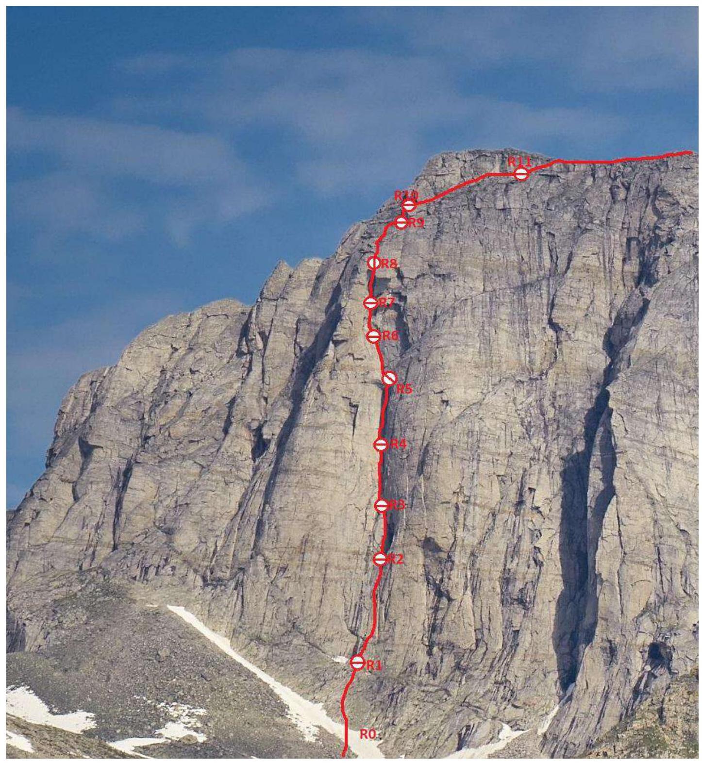
2.2. Scheme of the route in UIAA symbols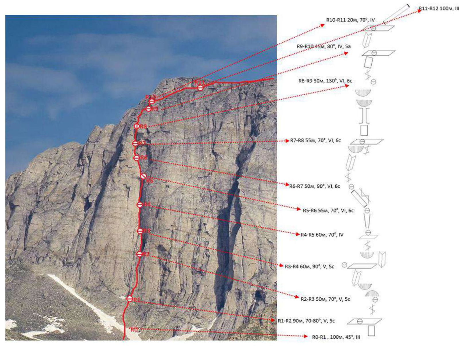
3. Characteristics of the Team's Actions
3.1. The approach to peak Kart from the base camp takes 1–1.5 hours. Along the Stlanikovaya River, pass the aufeis and move further up the gorge. Through the thickets of dwarf pine, climb up the grassy slope and exit to the lake under peak Kart. From the lake, turn left, walk along the wall about 200 m to the left upwards, under the beginning of the route there will be a large snowfield.
3.2. Description by Sections
R0–R1. Along the rocks of the third category of complexity, approximately 100 m to the exit to the shelf. 45°
R1–R2 From the shelf upwards along the system of cracks. Ninety meters, fifth-category climbing, 70–80. Reliable insurance on camalots.
5c
R2–R3 Along the large internal corner upwards in the direction of the cornice. The cornice is bypassed R0–R3 from left to right. The first 8 m there is no possibility to organize insurance, 70° slab, climbing is fifth-category (approximately 5c according to the French classification). Further, a diagonal crack begins with good relief for insurance (medium camalots), leading to the side of the cornice to its upper part. The cornice turns into an internal corner, upwards along it to the shelf. 50 m. R3–R4 Along the internal corner upwards. In the middle of the rope, there is another 1 cornice, which is easily passed by free climbing. Further, again an internal corner. At the end of the rope, a station on the shelf. 60 m. 5c. 90°. Large and medium camalots. R4–R5 From the shelf, movement along the couloir. The rocks are very heavily destroyed. Climbing IV.B. At the end of the rope, not very convenient station. Large and medium camalots, anchor hooks. Length of the section 60 m. 70 degrees. R5–R6 Inclined slab and internal corner, along which the route passes, which is passed by free climbing. Climbing up to 6c. Slope 70°, need large camalots (№4–5). 55 m. R6–R7 From the station, departure to the left, into the internal corner. In the middle of the rope, there is a cornice consisting of a huge living plug (2–3 m in diameter), very tense climbing. After that, exit to the shelf under a large cornice. 50 m. 90°. Climbing up to 6c. R7–R8 Passage of a large cornice. The first part of the cornice is wet and is passed on ITO. Further, it goes by free climbing along a large chimney located in the cornice. Large and medium camalots. Hanging station on the wall behind the cornice, on large camalots. Climbing 6c, slope 130°, 30 m. R8–R9 Along a large crack by free climbing, exit to a large shelf. Insurance on large camalots. Climbing 5a, slope 80°, 45 m. Convenient station on the shelf. R9–R10 From the shelf, descend to the left by 3–5 m, then to the right, along the internal corner 20 m. Climbing IV, 70°. Station on a large shelf. R10–R11 From the station along the inclined shelf to the right to the exit to the ridge 100 m. Climbing III. R11–R12 Simultaneous movement along the ridge 300 m, then the summit bastion is bypassed from the left along the snow, further along the third-category rocks — exit to the summit.
3.3. Photo of the team on the summit
3.4. Descent along the ridge in the eastern direction and further along the scree slope to the south, to the shoulder of peak Kart. From it, descent along the overgrown slopes into the valley of the Stlanikovaya River.
3.5. Photo-report by sections
Section
R1–R2
Section
R3–R4
Section
R7–R8
Section
R8–R9
Section
R9–R10
Section
R10–R11
Section R11–R12