
ASCENT DOCUMENT
-
Ascent class: rock.
-
Ascent area: Kuznetsky Alatau, Tiger-Tysh ridge.
-
Peak "Bolshoy Zub" (Big Tooth) 2048 m above sea level.
-
Route is combined, via the western counterfort.
-
Estimated difficulty category: 2B.
-
Height difference is about 600 m.
-
Pitons hammered: rock 4 pcs., chock stones 6 pcs.
-
Number of travel hours: ascent 4 hours, descent 3 hours.
-
No overnight stay is planned; the route is completed in 1 day.
-
Group composition: Voigt Alexander Vadimovich — team leader, Candidate for Master of Sports Skripko Vyacheslav Vitalyevich — Candidate for Master of Sports, authorized by USSR State Sports Committee. Gorelov Dmitry Nikolayevich — 2nd sports category. Ivanov Pavel Viktorovich — 2nd sports category. Muravyov Yuri Nikolayevich — 1st sports category. Petrova Valentina Alexandrovna — 2nd sports category. Telker Alexander Vladimirovich — 2nd sports category.
-
Team coach — Andryushkevich Konstantin Ivanovich
-
Departure to the route and return on March 8, 1988.
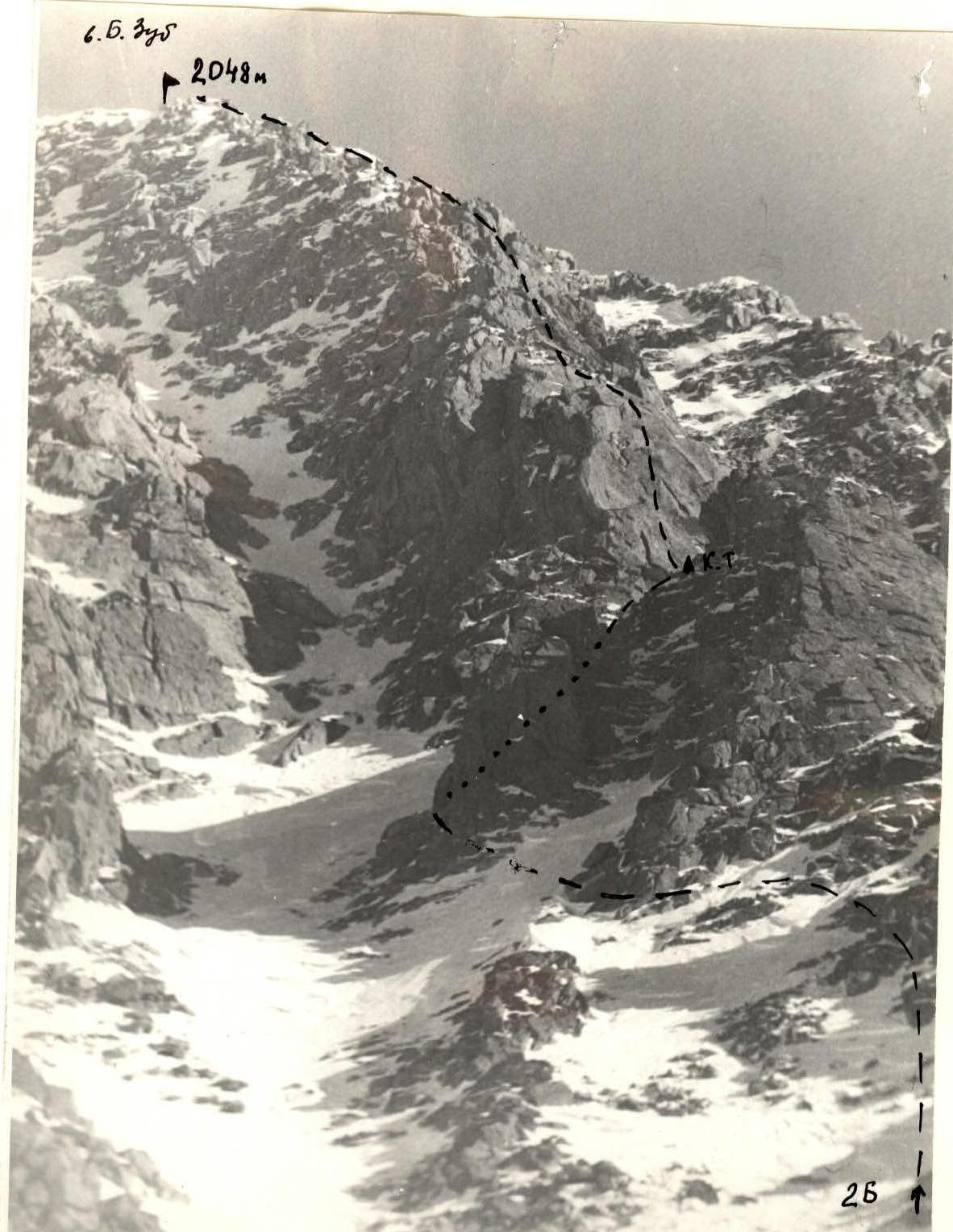 "Bolshoy Zub" via W counterfort, 2B category (section R2–R6)
Shooting point A.
Lens Jupiter + teleconverter
Focal length 270 mm.
"Bolshoy Zub" via W counterfort, 2B category (section R2–R6)
Shooting point A.
Lens Jupiter + teleconverter
Focal length 270 mm.
"Bolshoy Zub" via Western Counterfort (combined route, 2B category)
From the Graduates' Lake, we ascend to the cirque of Bolshoy Zub peak, under the western slopes of the peak. The general direction of the route is along the right western counterfort, leading directly to the peak. The approach to the route takes 1.5 hours.
The route begins with a 20-meter wall of easy, icy rocks with a steepness of 50°. Movement is simultaneous in teams, with protection through ledges. Further movement is along the ridge to the first gendarme. The gendarme is bypassed on the right, following the series of inclined shelves. Above, movement is on the left side of the ridge along easy rocks and hard firn with a steepness of 40° to a characteristic triangular gendarme. The gendarme is bypassed on the left, following hard firn with ice sections, with an exit to the right onto a sharp snowy ridge crest (possible cornices).
The steepness of the section is up to 60°, protection is through ice axe or pitons on rocky outcrops. From the ridge crest, a rocky wall with a steepness of up to 80° and a height of 80 m goes straight up, which is the key point of the route.
Under the rocky wall, in a niche, there is a control cairn. The first 40 m are passed directly, climbing up to a good ledge; climbing is above average difficulty, protection is piton. From the ledge, 40 m up and to the left along an icy internal corner, climbing is of average difficulty, with an exit to the ridge. Further movement is along the snowy ridge for 150 m, protection is through ledges, with an exit to the peak.
The ascent takes 4 hours. Descent from the peak along the northwestern ridge, 1B category, takes 3 hours.
Recommended equipment for a group of 6 people.
- Crampons 6 pairs.
- Main rope 3 x 40 m.
- Rock hammers 2 pcs.
- Rock pitons 5 pcs.
- Chock stones 8 pcs.
- Ice axes 6 pcs.
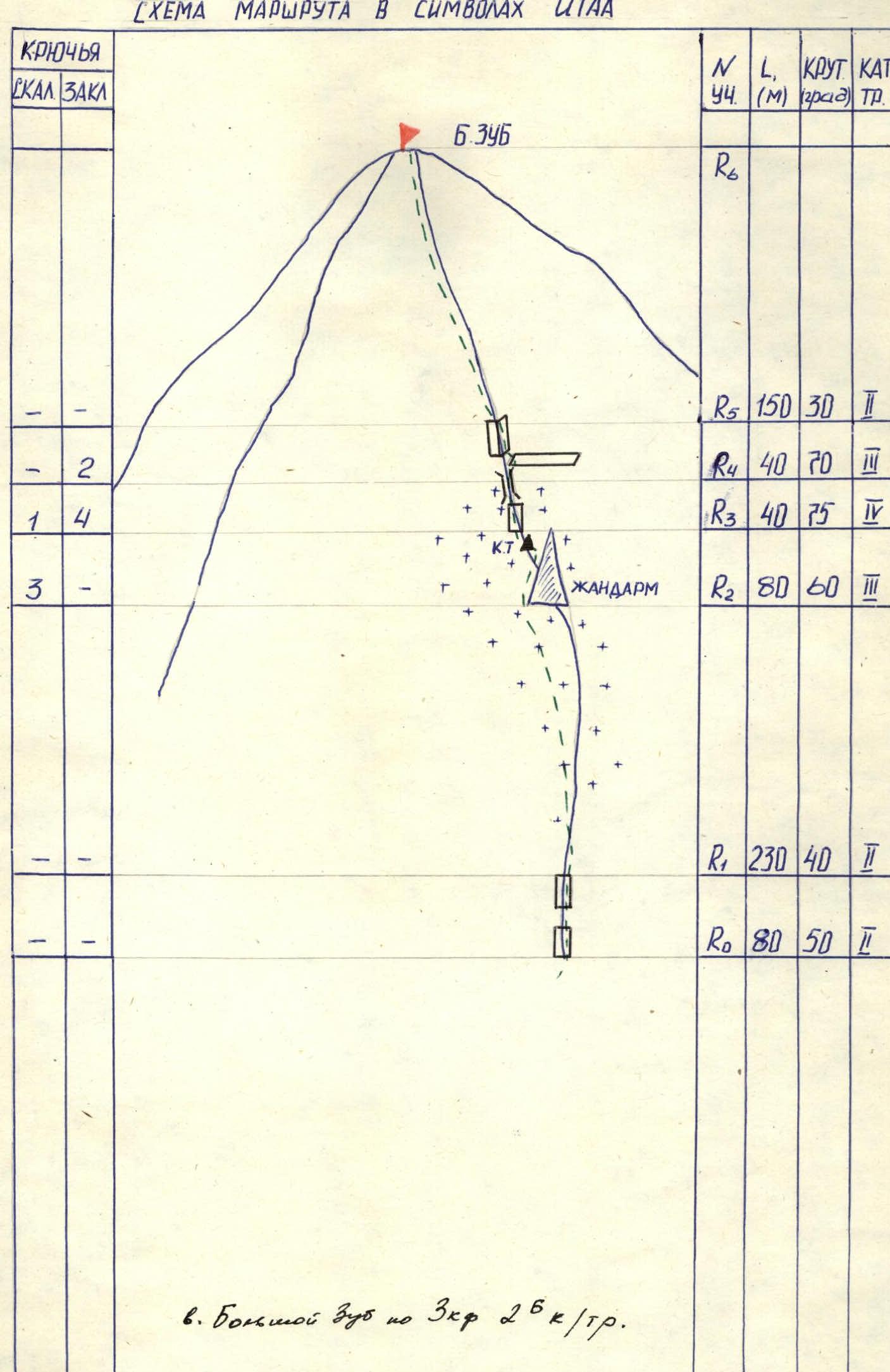 Route diagram in UIAA symbols
| Rock Pitons | Chock Stones | Section N | L (m) | Steepness (deg) | Category |
|---|---|---|---|---|---|
| R6 | |||||
| R5 | 150 | 30 | 2 | ||
| - | 2 | R4 | 40 | 70 | 3 |
| 1 | 4 | R3 | 40 | 75 | 5 |
| 3 | - | ||||
| R2 | 80 | 60 | 3 | ||
| R1 | 230 | 40 | 2 | ||
| R0 | 80 | 50 | 2 |
Comments
Sign in to leave a comment