
The address of the group leader: Perm, Druzhby st., house No. 16, apt. No. 58, postcode 614070. Tel.: (3422) 65-16-78. E-mail: otorten@ocpi.ru.
In the "Format" menu, specify the following:
- sent text
- use encoding — Cyrillic KOI8-R
Korolev A. Yu. All questions related to the ascent should be sent to this address.
The heights indicated in the report were determined using contour lines on a topographic map with a scale of 1:200,000.
Ascent Passport
- Ascent class — winter.
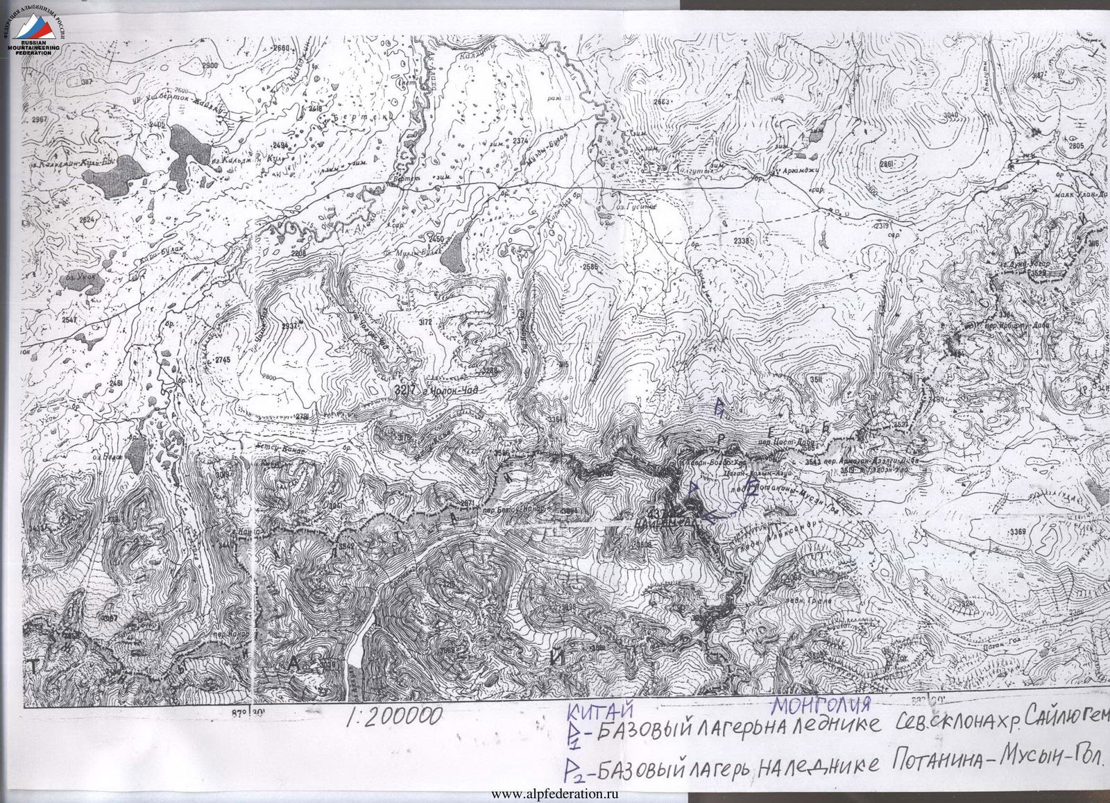
- Ascent area — Altai, Mongolian Altai ridge.
- Peak, route — v. Nayramdal along the eastern ridge, from the Potanin-Musen-Gol glacier.
- Category of complexity — 3Bz.
- Height difference — from the base camp to the summit — more than 800 m.
Route length — 4200 m from the beginning of the ridge, from the camp — 6200 m. Length of sections of 2nd cat. sl. — 3400 m. Length of sections of 3rd cat. sl. — 1200 m. Average steepness of the entire route — 10°. Maximum steepness — 50°, 100 m.
- Belay points — 31, using ice screws and ice axes.
- The route is ice and snow.
- Team's man-hours: to the summit — 7 hours, to descend to the base camp, on the Potanin-Musen-Gol glacier — 11 hours.
- Leader: Korolev Andrey Yuryevich — 2nd sp. разряд, Perm, Druzhby 16–58.
Participants: see above.
-
Overnights: all overnight stays in a tent, in the base camp.
-
Exit to the route: v. Nayramdal — March 14, 2001, return to the base camp — March 14, 2001.
-
Name of the organization: Perm Mountain Club — Lokomotiv stadium. The ascent was made as part of a ski hike of the 5th category of complexity in Altai. The peak — Nayramdal mountain, height 4374 m — the highest point of Mongolia, the Mongolian Altai ridge and the most powerful glaciation center in Altai, where three ridges converge — Saylyugem (from the east), South Altai (from the west) and Mongolian Altai (from the south). The ascent is a winter first ascent in the sense that it was the first time a route description was made. According to our information, people have climbed this ridge twice before: once in the summer of 1970, during an international climbing event with participants from Mongolia, Poland, GDR, and USSR, and again in the winter of 1998. It was a group of ski tourists from St. Petersburg led by Beketov. List of the team that made the ascent:
-
Korolev Andrey Yuryevich — 2nd разряд in mountaineering, CMS in sports tourism.
-
Shirokov Igor Vyacheslavovich — 1st разряд in sports tourism.
-
Bazhukova Lyudmila Sergeyevna — 3rd разряд with excess in mountaineering, CMS in sports tourism. Leader — Korolev Andrey Yuryevich. Date of ascent — March 14, 2001. There are newspaper publications about the ascent. Photograph of Nayramdal mountain and the ascent route profile. The picture was taken from the base camp, on the Potanin-Musen-Gol glacier.
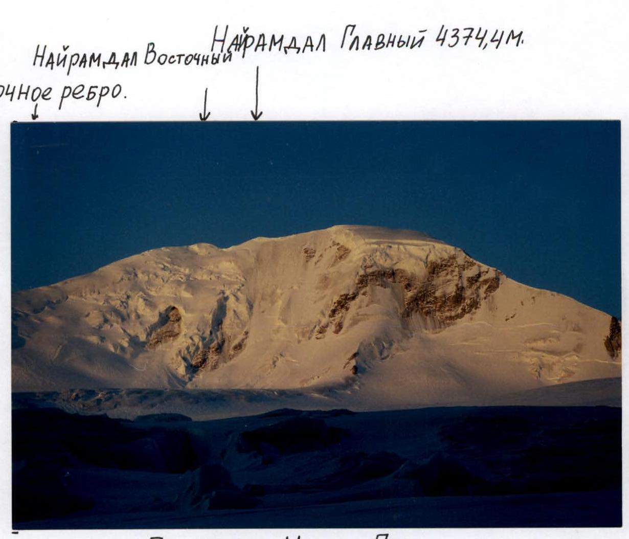
Potanin-Musen-Gol glacier.
Date and time of shooting: March 15, 2001, at 7:00.
Lens: Helios-44M-6 58 mm 1:2, M52 0.75 MS.
Camera: Zenit-122.
Distance to the object being photographed: to the summit of Nayramdal mountain — 2.5 km.
Height of the shooting point: approximately 3500 m.
Ascent Route. Along the Eastern Ridge
Brief Overview of the Ascent Area
Nayramdal mountain is the second highest peak in Altai, the highest point in Mongolia and the Mongolian Altai ridge. The peak is very difficult to access.
The nearest settlement is the border outpost "Argamdzha", located in a straight line 20 km from the mountain. The outpost's communication with the outside world is irregular:
- In winter, it is no more than once a month, and only if a bulldozer clears the road.
- In summer, communication is more frequent.
The road is difficult, through passes, with a height of up to 3000 m — Teply Klyuch pass. There is a Russian border guard checkpoint on it, and a bulldozer driver lives there permanently to clear the road through the pass as needed.
The nearest settlement, apart from the outpost, is the village of Kosh-Agach. It has a population of over 4000 people and has regular bus service to the capital of the Altai Republic — Gorno-Altaisk. Kosh-Agach is 140 km from the mountain.
To visit the area, a border zone permit is required, which can be obtained from the border detachment located in the village of Aktash.
To climb the peak, it is necessary to enter Mongolia, so a visa is required.
Transport:
- In Kosh-Agach, you can hire a vehicle.
- In winter, you can drive along the road to the "Argamdzha" outpost for 60 km, where the road is not too snowy.
- Further, the road exits the Tarhata river valley and is heavily snowed over, so you can only drive on an Ural all-terrain vehicle or a ZIL 131, and even then, not always.
- In summer, you can drive to the "Argamdzha" outpost on a UAZ vehicle.
Features of winter travel:
- In winter, it is necessary to travel on skis.
- It makes sense to take sledges to lighten the weight of backpacks. It is convenient to walk with them because the places are open, and there is forest only in the Jazator river valley.
- A strong wind often blows, which compacts the snow to the state of firn.
Climatic conditions in March:
- At night, the temperature often drops to -40 °C.
- During the day, it rarely drops below -20–25 °C, and can rise to -5 °C.
- The weather is clear on 60% of days, but the wind often blows.
- Wind speed can reach 25–30 m/s, and in such winds, there is usually no visibility.
The presence of strong winds must be taken into account when climbing Nayramdal peak along the eastern ridge, because it is very exposed and rises above all the surrounding ridges.
History of ascents to Nayramdal along the eastern ridge:
- Two groups have climbed Nayramdal peak along the eastern ridge before us: in 1970 — participants in an international climbing event, and in the winter of 1998 — a group of tourists from St. Petersburg led by Beketov.
- In 1996 — Muscovites climbed a traverse of peak 4104 m.
 Nayramdal, the route was rated 3A cat. sl.
From the summit, we retrieved a note left by Tula tourists on August 3, 2000, who traversed g. Nayramdal.
You can get to the area via Novosibirsk, from where a daily express train runs to Biysk. From Biysk, take a regular bus or taxi to Gorno-Altaisk, then a regular bus that runs 3 times a week to the district center Kosh-Agach. The schedule changes frequently, so I do not provide specific data.
Kosh-Agach is located in the Chuya steppe — this is the cold pole of Altai, it is quite low, and cold air flows into it from the surrounding mountains. There is usually no snow in the Chuya steppe in winter. We were lucky because it was the first time in many years that snow had fallen there, and we could travel on skis and sledges.
In the Jazator river valley and around the Tarhatinskoye lake, the snow is deep and dense every year. Along the road to the Teply Klyuch pass and along the Jazator river, there are many winter huts suitable for overnight stays. They are built by local hunters, fishermen, and shepherds.
The Kalguty river valley and the U kok plateau located to the north are famous for their ancient Scythian burial grounds dating back to 3000 years or more. One of the latest finds is particularly interesting: in the 90s, archaeologists discovered a very rich and surprisingly well-preserved burial ground of a Scythian princess dating back 3000 years. The princess herself was very well preserved — archaeologists were initially frightened because they thought she was sleeping. But as soon as they removed her from the permafrost, she began to darken, and measures were taken to preserve her.
The archaeologists conducted excavations rather crudely: they poured boiling water to thaw the permafrost. Then the mummy of the princess was sold abroad, where it is currently located, and from where they are trying to return it to the local local history museum.
During the burial of Scythian people of noble birth, their servants, warriors, animals, household property, and jewelry were killed and buried alongside them to help their masters in the afterlife. Therefore, ancient Scythian burial grounds need protection from predatory looting.
But they are somewhat protected by their inaccessibility and the presence of a border zone, which is not accessible to everyone. Scythian burial grounds, like the pyramids of pharaohs, also have a very terrible and hitherto incomprehensible protection. The fact is that both archaeologists who first disturbed the rest of the pharaohs and those who crudely removed the Scythian princess from the eternal ice died in the following years for various reasons, although most of them were young and healthy people.
Nayramdal is located in the center of the most powerful glaciation center are the most powerful nodes of glaciation in Altai. Two of the most powerful glaciers in Altai flow from the slopes of the peak to the east:
- to the north — the Potanin-Musen-Gol glacier,
- to the south — the Alexandra glacier.
The Potanin-Musen-Gol glacier is the most powerful and longest glacier in Altai. Its length is 16 km. To the west, Nayramdal is bordered by steep two-kilometer walls, rising above the glaciers in the upper reaches of the Sangadyr river.
Ascent Schedule
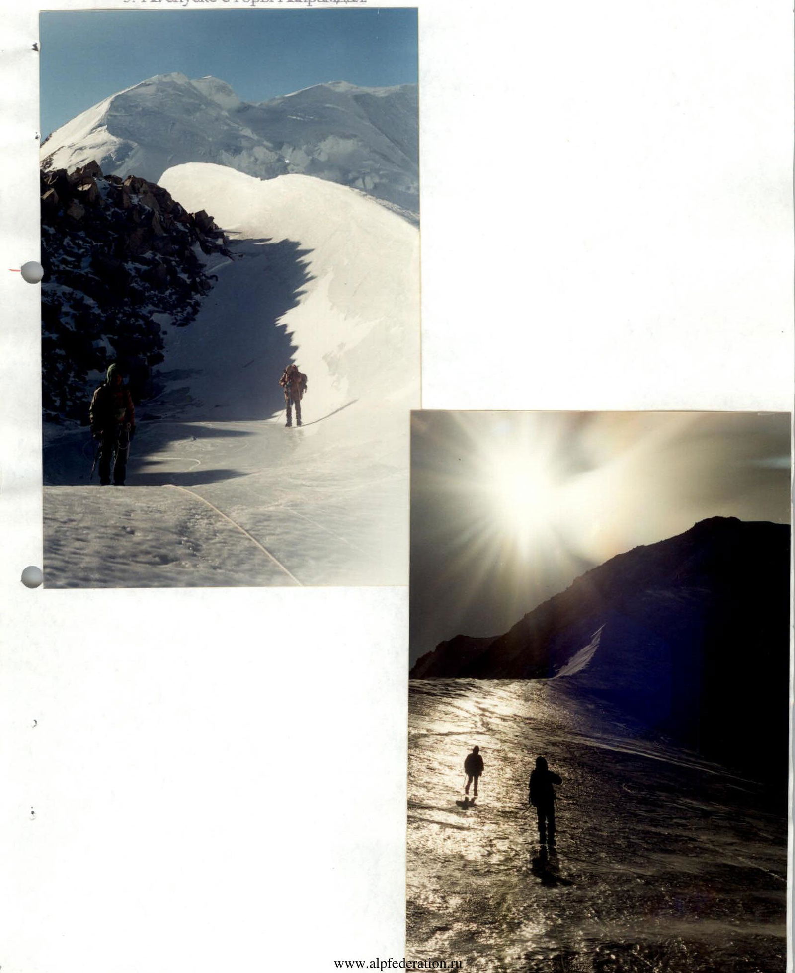
We set out at 8:00 from the base camp on the Potanin glacier. Temperature -35 °C, a moderate wind is blowing. The cloud cover is variable, with haze. We are walking in crampons and in a rope team.
We climb onto the ridge at 9:00. The ridge is icy, not very sharp and sloping in the lower part. There are rock outcrops. We move with simultaneous belay. The ice is very hard, the drills hardly go in.
Higher up, the ridge becomes sharper, and in some places, there are ascents with a steepness of up to 40°, extending 20–30 m.
Further along the ridge, it becomes very sharp, with an ice cornice on the south side, extending 200 m — alternate belay with ice screws is necessary.
Further, the ridge widens, but an ice ascent begins with a steepness of up to 35°, with closed and open crevasses, extending 100 m — also requires alternate belay with ice screws.
Then there is a sharp, in some places with a steepness of up to 40–50°, ice-firn ridge that leads to the eastern peak.
From the eastern peak, there is a descent to the saddle between it and the main peak along a fairly sharp ice-firn ridge with a steepness of within 25–30°.
The ascent to the main peak is along a ridge with a steepness of up to 40°, requiring belay with ice screws over a distance of 200–250 m. The ridge is in some places very sharp, mostly icy.
We reached the summit at 15:00. Visibility improved, and the haze disappeared. There was no cairn on the summit. We retrieved a note from a cairn located on the eastern peak. It was left by a group of Tula tourists on August 3, 2000. We left our own note in the cairn.
The descent from the summit along the ascent route takes 4 hours. We arrived at the base camp at 19:00.
Conditions throughout the day:
- A gusty wind of moderate strength blew all day.
- The temperature did not rise above -15 °C in the sun.
- In the evening, it dropped again to -35 °C.
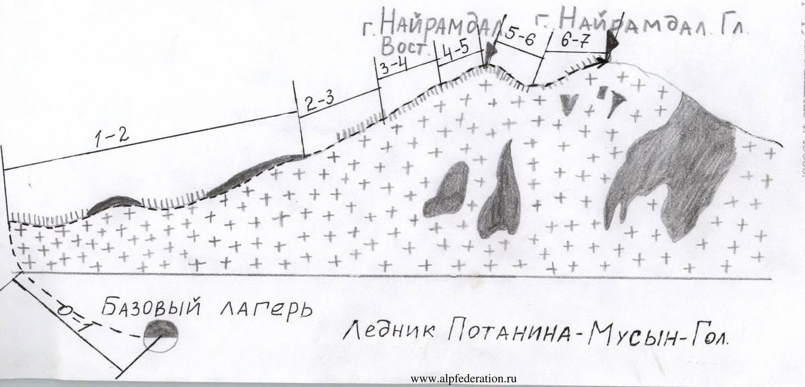
Tactical Actions of the Team and Description of the Route by Sections
Section R0–R1. Base camp — beginning of the eastern ridge of Nayramdal mountain. Category of complexity — 1, rarely 2, as there are closed crevasses. The path is mainly on very hard ice, which is often heavily broken. Movement in a rope team and crampons, with simultaneous belay. Length — 2 km, duration — 1 hour.
Section R1–R2. Beginning of the ridge — to the sharp part of the ridge. Cat. sl. — 2. Icy ridge with outcrops of destroyed rocks, 3–5 m wide, steepness within 35°, but mostly gentler — 25°, and there are almost horizontal sections. Hard ice. Length 2–2.5 km, duration — 2 hours. Movement: in a rope team, in crampons, with simultaneous belay.
Section R2–R3. Narrow place of the ridge, up to several centimeters wide. To the south — a sheer drop, to the north — up to 40°. Length — 200–300 m, duration — 1 hour. Movement in crampons, with alternate belay using ice screws. It is possible to go out onto the northern part of the ridge and walk along it with simultaneous belay, but it is undesirable because the winter ice is very hard, and crampons do not hold well. Number of belay points used — 6. Cat. sl. — 3.
Section R3–R4. End of the narrow part of the ridge — ice slope with closed and open crevasses. Steepness up to 40°. Movement along the rope, fixing the rope with ice screws. Number of belay points used — 7. Length — 200–250 m, duration — about 1 hour. Cat. sl. — 3.
Section R4–R5. Ice-firn ridge leading to the eastern peak. Length 300–400 m. Steepness within 35–40°, with sections up to 50° extending no more than 20 m. Movement with alternate and simultaneous belay. Belay using ice axes and ice screws. Category of complexity — 2 and 3. Duration — about 1 hour. Number of belay points — 7.
Section R5–R6. Icy ridge descending to the saddle between the eastern and main peaks.
- Length: 300–400 m
- Duration: 45 minutes
- Ridge width: 1.5–5 m
- Steepness: within 30°, mostly gentler
- Movement: with alternate and simultaneous belay
- Number of belay points used: 3
- Category of complexity: 2 and 3
Section R6–R7. Ascent to the main peak from the saddle along the icy ridge.
- Steepness: 40°
- Length: 400–500 m
- Ridge width: 1.5–5 m
- There are cornices on the south side
- Duration: 1.5 hours
- Category of complexity: 3
- Number of belay points used: 8
- Belay: with ice screws
- Movement: with alternate belay and along the rope
Route Description in Symbols
Peak g. Nayramdal Main 4374.4 m
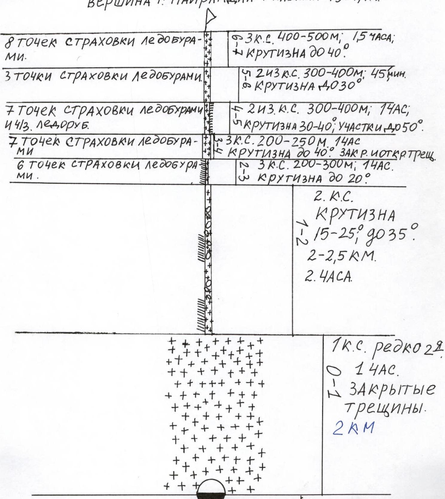
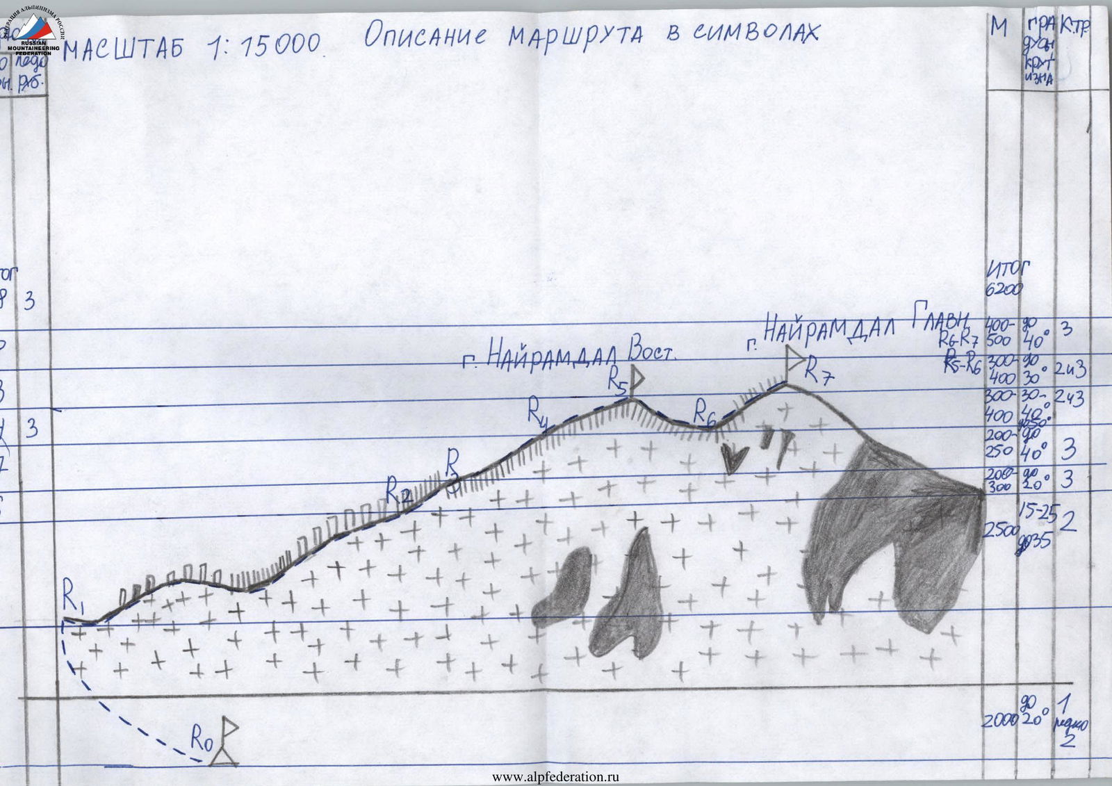
Scale 1:15,000.
- Section R0–R1: Cat. sl. 1, rarely 2. Length 2 km, duration 1 hour. There are closed crevasses.
- Section R1–R2: Cat. sl. 2. Length 2–2.5 km, duration 2 hours. Steepness 15–35°.
- Section R2–R3: Cat. sl. 3. Length 200–300 m, duration 1 hour. 6 belay points with ice screws. Steepness up to 40°.
- Section R3–R4: Cat. sl. 3. Length 200–250 m, duration 1 hour. 7 belay points with ice screws. Steepness up to 40°. Closed and open crevasses.
- Section R4–R5: Cat. sl. 2 and 3. Length 300–400 m, duration 1 hour. 7 belay points with ice screws and ice axes. Steepness 35–40°, sections up to 50°.
- Section R5–R6: Cat. sl. 2 and 3. Length 300–400 m, duration 45 minutes. 3 belay points with ice screws. Steepness up to 30°.
- Section R6–R7: Cat. sl. 3. Length 400–500 m, duration 1.5 hours. 8 belay points with ice screws. Steepness up to 40°.
Photo Illustration of the Ascent
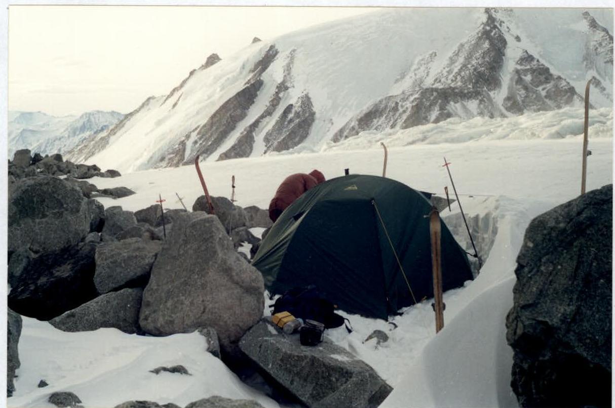
- Base camp on the Potanin-Musen-Gol glacier. Further, the camera froze, and the ascent to the peak was not captured. The camera worked on the summit because it warmed up and the sun came out.
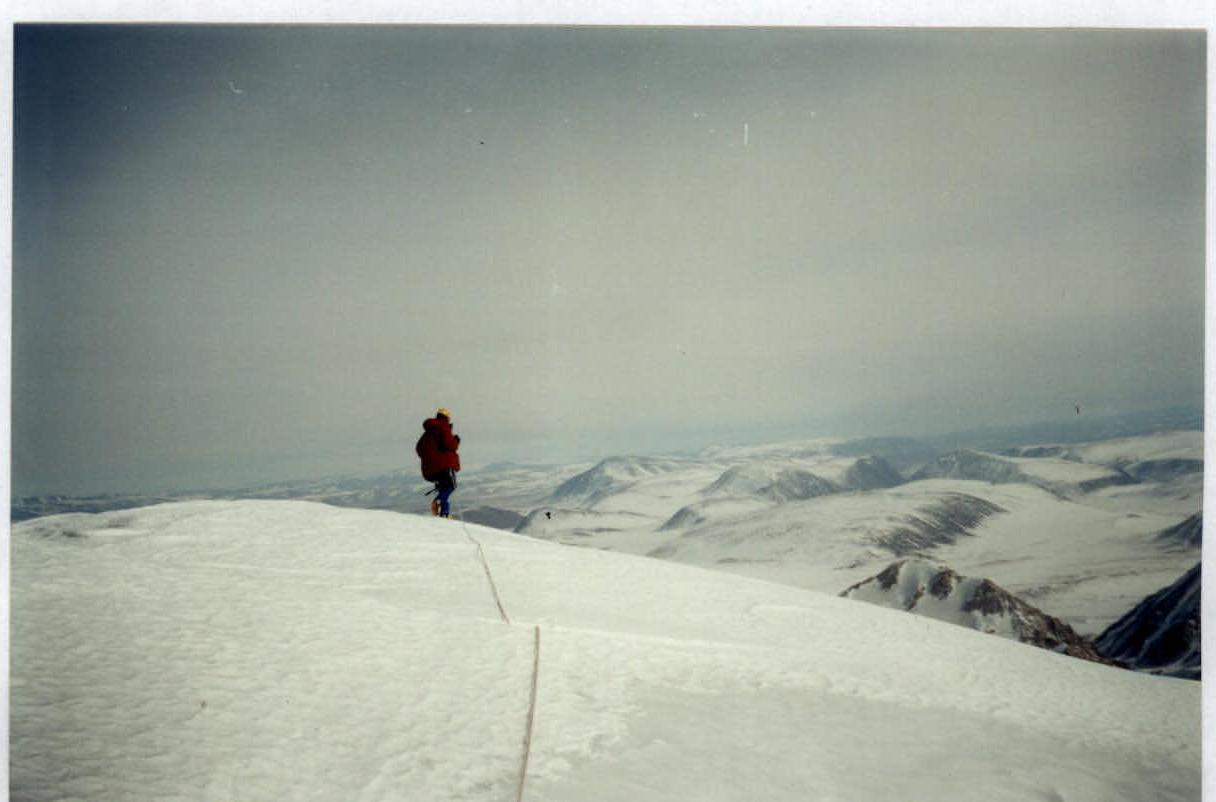
- A. Korolev on the summit of Nayramdal mountain.
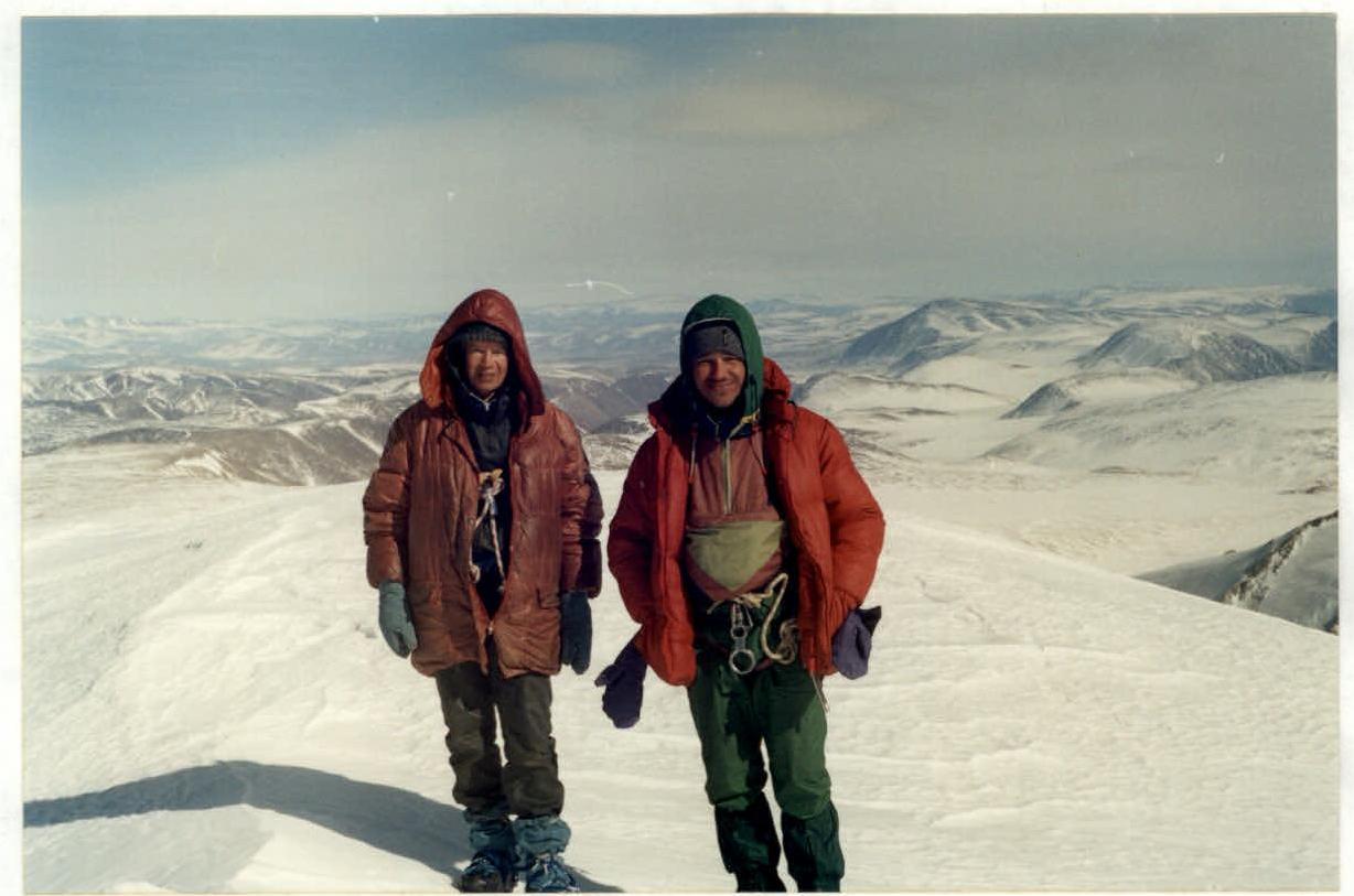
- L. Bazhukova and I. Shirokov on the summit of Nayramdal mountain.
- Section R2–R3 on the descent from Nayramdal mountain.
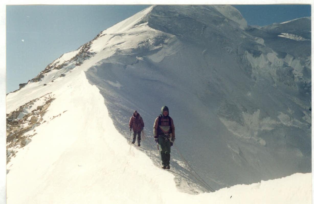
- On the descent from Nayramdal mountain.
Appendix 1
A copy of the note retrieved from the cairn on the eastern peak of Nayramdal mountain is attached. There was no cairn on the main peak because there are no rock outcrops there.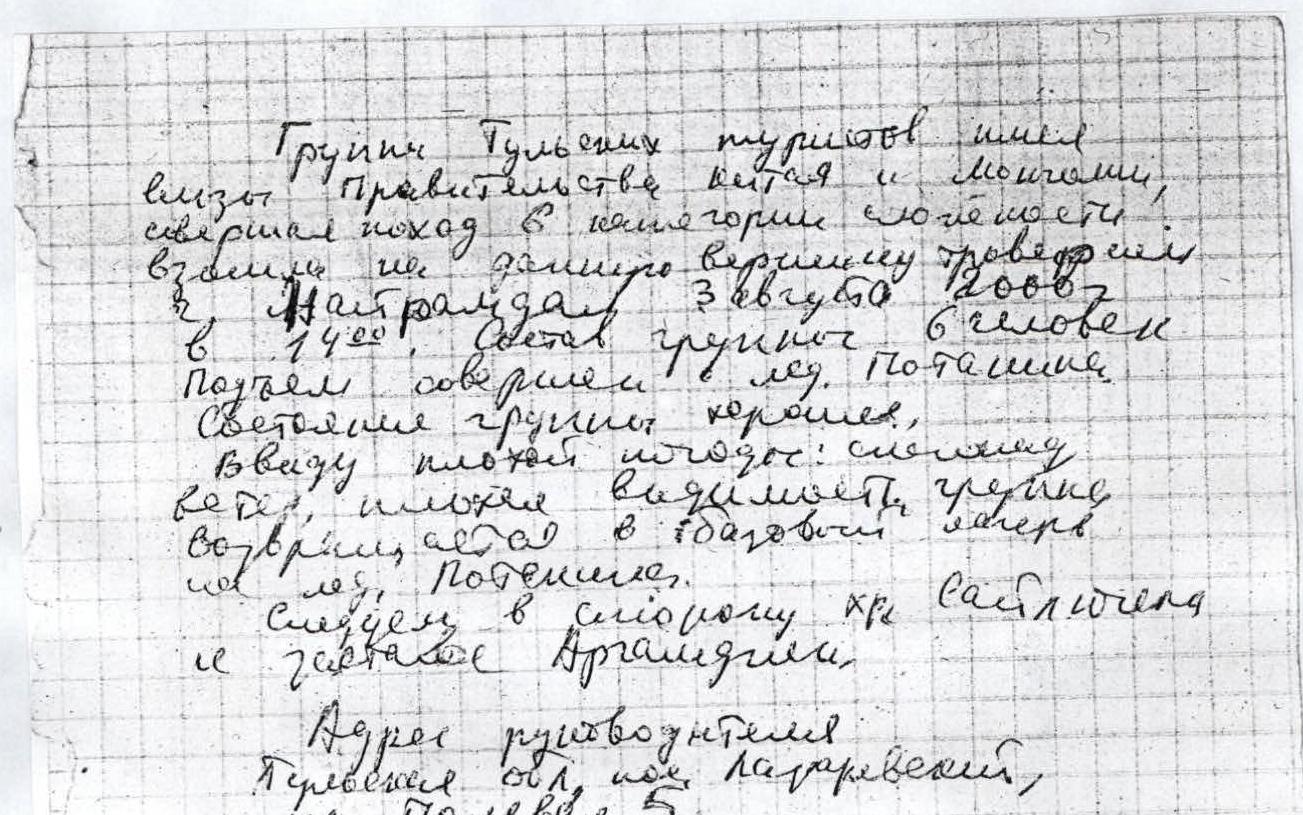
"A group of Tula tourists, traveling under the Government of Mongolia, completed a hike in the category of complexity and ascended the peak by traversing Nayramdal. The ascent was made by three people in 18 years. Potanin. The condition of the group is good due to bad weather: snow, wind, shlyapa. We oriented ourselves well, warmed up. Visibility. To the base camp on the Potanin glacier. We are heading to the Saylyugem power ridge and the Argamdzha outpost. The leader's address: Perevezentsev, st. Polevaya, 5".
Comments
Sign in to leave a comment