
Passport
- Altai, South Chuya Ridge, Akkol gorge (Sofiysky glacier area), 1.3
- Sister (Middle) – Sister (3) 3721 m traverse.
- Proposed category 2B, first ascent.
- Route type — mixed.
- Height difference 225 m. Distance 800 m. Average slope of the main part of the route 29°, total route 22°.
- Ice screws used — 6.
- Total climbing time — 5 hours (from the bergschrund).
- Leader Drakkin Andrey Valentinovich CMS, 1st sports category, № 68.
- Participants: Abornev S. — 3rd sports category
Danilov A. — 3rd sports category
-
Approach to the route July 21, 2004 at 06:00, reaching the summit of Sister (Middle) at 11:00, reaching the summit of Sister (3) at 13:00, return to the bivouac at 17:00.
-
Organization — West Siberian Search and Rescue Team of the EMERCOM of Russia named after V.V. Zyukov.
 Mt. Sister (Middle) taken from shooting point № 1
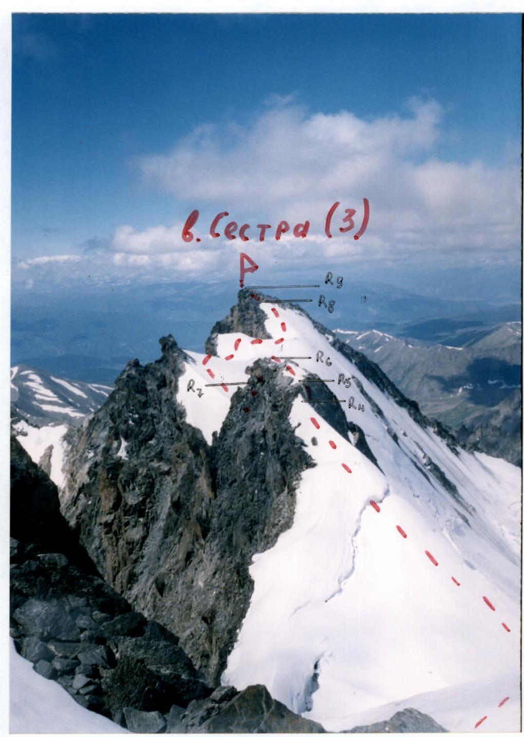 Mt. Sister (3) shooting point № 3
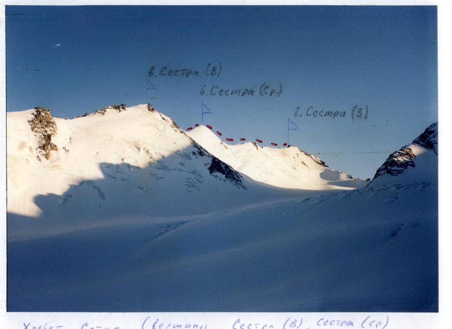 Sotka Ridge (peaks Sister (Tall), Sister (Middle), Sister (3)). Shooting point № 2
UIAA SYMBOLS ROUTE SCHEME
Sotka Ridge (peaks Sister (Tall), Sister (Middle), Sister (3)). Shooting point № 2
UIAA SYMBOLS ROUTE SCHEME
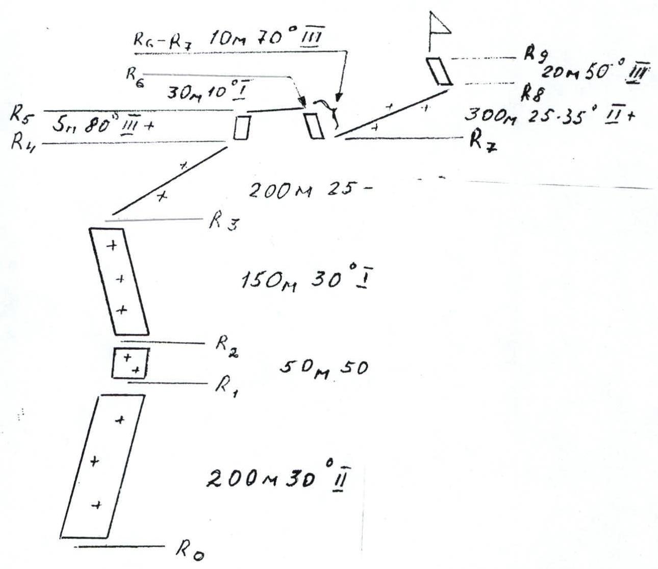

Peak Sister (Middle) – Sister (3) traverse. 2B category (tentative)
Approach
From the base camp, located at the confluence of the Tura-Oyuk and Akkol rivers, move along the Akkol river to the Sofiysky glacier. A faint trail initially goes along the swampy slopes, then along the scree. Ascend to the glacier and move along it in the direction of the right (orographically) branch of the glacier, bounded by the ridges of peaks B.Luzhetsky, Sister, Chuya. Ascend to the beginning of this branch of the glacier. In the lower part, a stream flows on the moraine ridge to the left. There are places to pitch tents near it in the folds of the moraine ridge. A convenient bivouac site.
Approach time: 4–5 hours from the base camp.
Route Description
From the bivouac, move in the direction of the southeastern slope of the Sister (Middle) peak along the glacier. The ascent is gradual and calm. Time to approach the slope — 2.5–3 hours.
Ascent to the col is icy:
- In the lower part, the icy slope is 30° steep
- Gradually, the steepness increases to 45°
- The last 50 m are 50° steep
- Total slope length 250 m
- Movement is alternating
- Protection via ice screws
- Ropes can be fixed in the upper part
From the col, the ascent to the summit leads along a steep snowy slope. The ascent time from the bergschrund to the summit takes 2–2.5 hours.
Movement towards the Sister (3) peak goes along a snowy-icy ridge, where two gendarmes are encountered.
-
The first gendarme is climbed head-on.
-
In the upper part, a rock wall of difficult climbing, 5 m long, is encountered.
-
Descent from the gendarme is along a 10-meter rock wall.
-
On descent and ascent, movement is alternating, protection via rock features.
-
The second gendarme is bypassed on the right along an icy slope.
-
Movement is alternating, protection via ice screws.
-
The ascent to the Sister (3) peak is along a 20-meter rock wall.
-
Climbing is of medium difficulty.
Descent is via the ascent route. Safety recommendations:
- When approaching the southeastern slope in the upper part of the glacier, closed crevasses are encountered.
- It is recommended to travel in rope teams.
- When ascending to the col, do not cling to the rocks on the left and right.
- Rockfall is possible.
Equipment recommendations. The route is mixed. A standard set of ice climbing equipment is required. Passage of rock sections is possible with protection via rock features.
Comments
Sign in to leave a comment