ASCENT PASS TO THE SUMMIT "Pik Petra I"
July 10, 2001
- Ascent type — ice and snow.
- Ascent area — Altai, South-Chuya Ridge.
- Summit — Pik Petra I, height — 3422.0 m, route is combined — snow, ice, rocks.
- Expected category — 1B.
- Route characteristics: height difference — 500 m, length — 900 m, average steepness — 45° without a ridge.
- Number of ice screws driven — 12, rock screws — 2.
- Number of hours on the move — 7 hours.
- Leader — German G. Andreev, Master of Sports. Evgeny P. Kuznetsov, Candidate for Master of Sports. Second ascent of the route: Leader — Yuri I. Gerzhberg, Candidate for Master of Sports. Climber — Andrei V. Valakhnichev. Climber — Gennady D. Li, Candidate for Master of Sports.
- Organization — Alpine Club "St. Petersburg" and FASIL St. Petersburg.
Route Diagram

- R1: 40 m, 35°, difficulty category 1
- R2: 40 m, 40°, difficulty category 1
- R3: 40 m, 40°, difficulty category 1
- R4: 40 m, 45°, difficulty category 1
- R5: 40 m, 45°
- R6: 40 m, 50°
- R7: 40 m, 50°
- R8: 30 m, 70°
- R9: 40 m, 10°
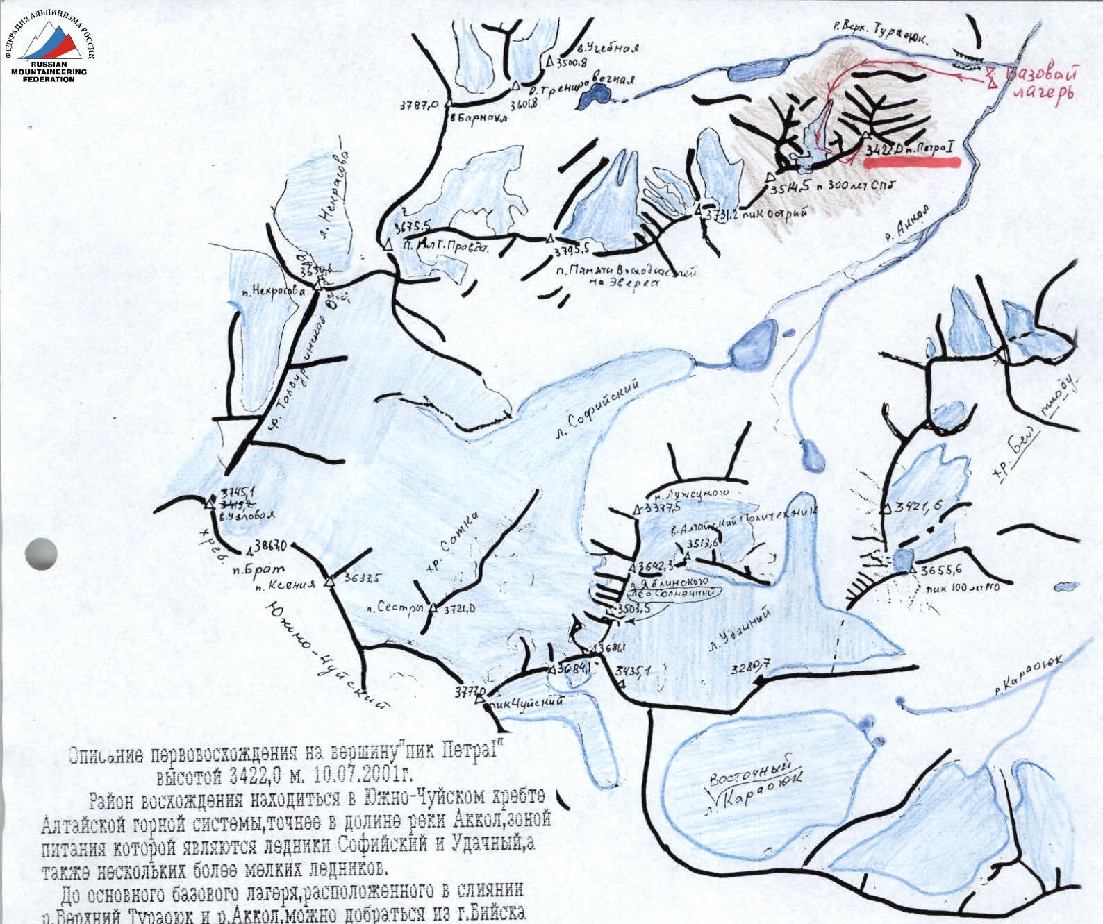
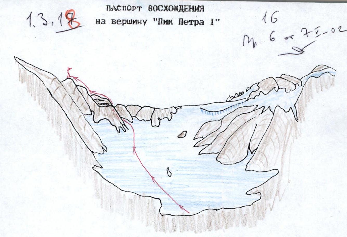
Description of the first ascent to Pik Petra I (3422.0 m), July 10, 2001
The ascent area is located in the South-Chuya Ridge of the Altai mountain system, more precisely — in the Akkol river valley, which is fed by the Sofiyskiy and Udachny glaciers, as well as several smaller glaciers.
To reach the main base camp, located at the confluence of the Verkhny Turauk and Akkol rivers, one can travel from Biysk along the Chuya Highway to the Ortolyk settlement (590 km), then, crossing the Chuya River, to the Beltir settlement. In Beltir, transfer to an all-terrain vehicle (345–66) and follow the left orographic bank of the Chegan-Akkol River to the Akkol River, and then to the confluence of the Verkhny Turauk River.
From the camp, move along the Verkhny Turauk River, keeping to the right orographic slope of the ascending valley. After 30 minutes, a large-boulder talus begins, leading to the first cirque of the Rzhan-Chiy Ridge spur, where the Pik Ostry (3731.2 m) and Pik Pamyati voskhodyaschey na Everest (3614.0 m) are located. The cirque contains a cirque glacier. The journey from the camp takes 1 hour 30 minutes.
From the north, the cirque is closed by a steep rocky wall, which in the western part turns into an ice fall with an overhanging cornice.
The route begins in the eastern part of the glacier, where a couloir is clearly visible. Initially, the glacier slope is 20°, then the steepness increases, and ice appears three rope lengths before the couloir mouth.
Equipment:
- Crampons
- Ice screws
Start of the route. Slope — 35–40°. Couloir is steep, icy, with steep sides: the right side is a monolith, the left is heavily fractured.
Route passage:
- Up to the last rope length, move through the center of the couloir (sections R4–R7) with protection via ice screws.
- Before reaching the rocks (an internal corner leading to the ridge) — protection in a rocky stone to avoid dropping rocks on the belayer.
- Exit to the ridge via a very steep, rock-filled internal corner, and then along a small wall.
- The ridge is wide with low jandarms — follow the ridge left for 400 m.
- Cairn — on the highest of them.
Time:
- From the start of movement along the glacier — 4 hours.
- Descent via the ascent route — 3 hours.
Protection:
- Ice screws — 6 stations with 2 pieces each.
- Rock screws — 1 station with 2 screws.

View of the South-Chuya Ridge spur, dividing the Akkol and Verkhny Turauk river valleys. Taken from Pik 100 let RGO. Photo by A.V. Valakhnichev.