Passport
I. Category of First Ascent. 2. Altai, South-Chuya Ridge, Sofiyskiy Glacier area. 3. "Pamyati voskhoditeley na Everest" (B-3) traverse with ascent via the NE ridge snow-ice saddle. 4. Proposed category 4A, first ascent. 5. Height of the eastern summit 3710 m, western 3720 m. Elevation difference 920 m, length 1760 m. 6. Pitons: 22 ice screws for belay. 7. Climbing hours 13. 8. Overnight stays: not necessary. 9. Leader Drakin Andrey Valentinovich CMS.
Participants: Barnov Sergey Ivanovich 1st sports category, Okhtimenko Irina Nikolaevna 2nd sports category. 10. Coach Drakin Andrey Valentinovich 1st category №68.
II. Departure for the route, summit, return August 8, 1998.
- Organization: Altai Krai Alpine Federation.
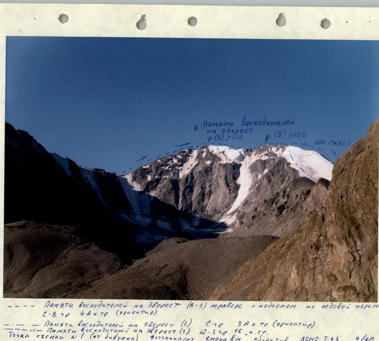
--- "Pamyati voskhoditeley na Everest" (B-3) traverse with ascent via the NE ridge snow-ice saddle category 4A (reference point) --- "Pamyati voskhoditeley na Everest" (3) Sgr category 3A (reference point) --- "Pamyati voskhoditeley na Everest" (3). 10–328, 154.TS. Photo point № 1 (from the bivouac). Camera Smena 8M, lens LOMO T-43 4/40.
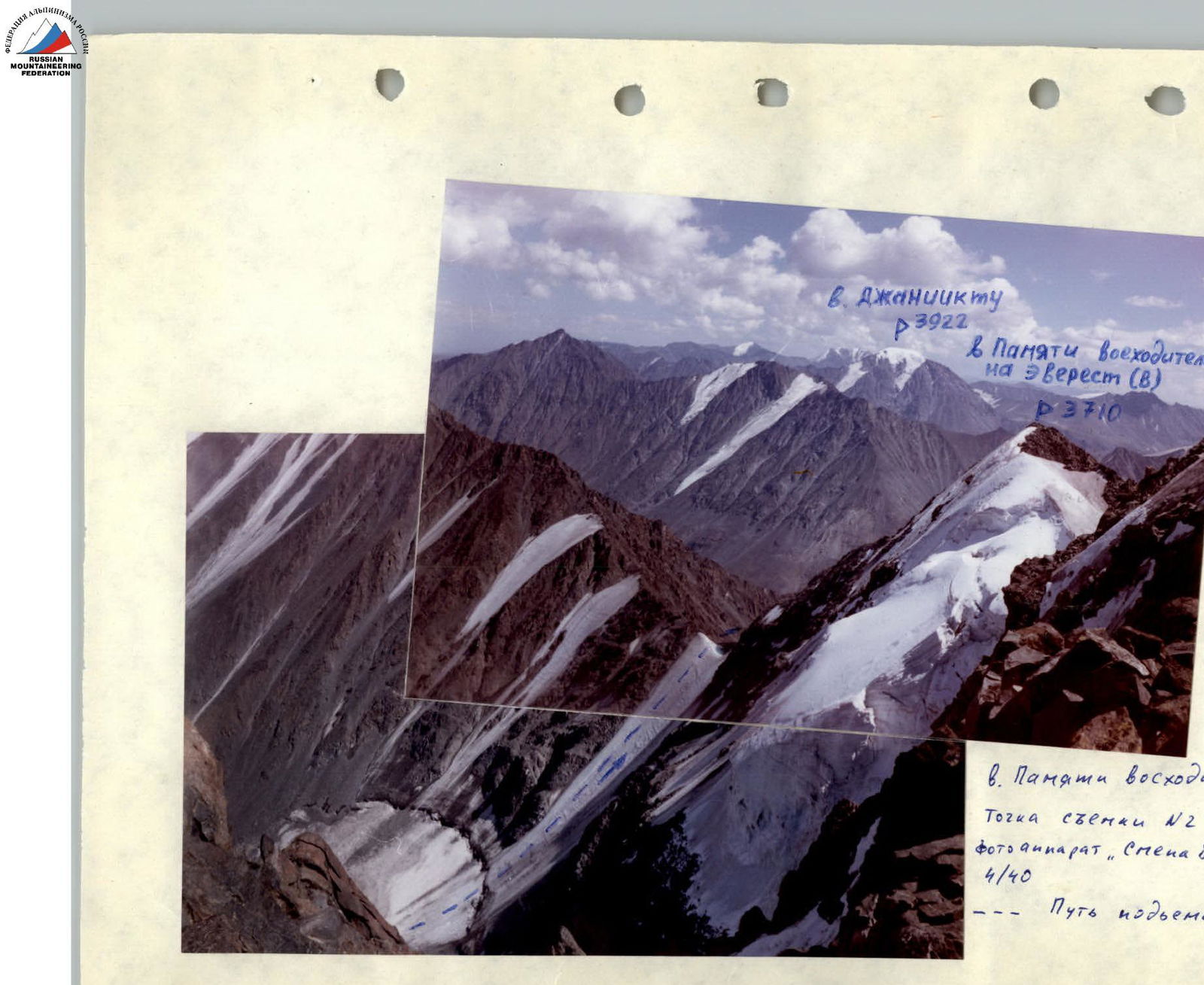
Above the image: Peak Dzhanikiktu 3922 Peak "Pamyati voskhoditeley na Everest" (B) P3710
Below the image: Peak "Pamyati voskhoditeley na Everest" (B) Photo point № 2 (on the ridge behind the 3rd summit). Camera Smena 8M, lens LOMO T-43 4/40. --- Path to the snow-ice saddle.
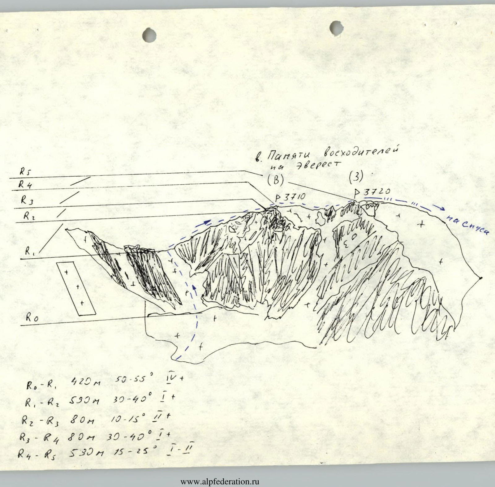
Above the image: Peak "Pamyati voskhoditeley na Everest" (B) P3710 (3) P3720 on descent
Below the image: R0–R1: 420 m, 50–55°, IV+ R1–R2: 590 m, 30–40°, II+ R2–R3: 80 m, 10–15°, II+ R3–R4: 80 m, 30–40°, II+ R4–R5: 530 m, 15–25°, I–II
Approach to the Route
From the base camp at the confluence of the Turasyuk River and the Akkol River, move along the Turasyuk River. The first ascent leads to the marshy bottom of the valley, crossing which, approach the moraine rampart, behind which lies the lower lake of the Turasyuk River cirque. Follow the marshy shore along the lake and ascend to the next moraine rampart. Establish a bivouac on the moraine rampart. Time from the base camp 2–2.5 hours.
Route Description
From the bivouac on the moraine rampart, descend to the stream, moving towards Peak "Pamyati voskhoditeley na Everest". Cross the stream, ascend to the talus slope formed by the middle scree, cross it, and exit onto the glacier. Approach the start of the ascent to the snow-ice saddle via the glacier.
Time from the bivouac: 2–2.5 hours.
The ascent is a snow slope with a steepness of 50–55°, length 420 m. This is the key section of the route. It is climbed with thorough piton belay and rope protection.
Recommendation: Climb this section at dusk. As soon as the sun illuminates the rocks, rockfall begins.
From the snow-ice saddle, move along a straightforward rocky ridge 500–600 m. In the upper part of the ridge, there is a section 60–80 m long, category 2–3, requiring protection via a projection. The first gendarme of this section is bypassed via a ledge on the left. The ascent to the Eastern summit follows a straightforward ridge. Time from the snow-ice saddle – 2 hours.
The traverse from the Eastern to the Western summit is a straightforward ridge traverse. The gendarme in the middle of the ridge is bypassed on the left via simple, broken rocks. Time from the Eastern to the Western summit – 2 hours.
Descent via the SW ridge follows a category 1B route.